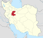
Khondab County
Appearance
Khondab County
شهرستان خنداب | |
|---|---|
 Location of Khondab County in Markazi province | |
 Location of Markazi province in Iran | |
| Coordinates: 34°21′N 49°15′E / 34.350°N 49.250°E | |
| Country | |
| Province | Markazi |
| Capital | Khondab |
| Districts | 1 (2006) |
| Population (2006) | |
| • Total | 59,112 |
| Time zone | UTC+3:30 (IRST) |
| • Summer (DST) | UTC+4:30 (IRDT) |
Khondab County (Persian: شهرستان خنداب) is located in Markazi province, Iran. The capital of the county is Khondab.[1] At the 2006 census, the county's population as a part of Arak County was 59,112, in 15,075 families.[2] It was separated from Arak County in 2007.
Administrative divisions
| Administrative Divisions1 | Pop. |
|---|---|
| Khondab District | 59,112 |
| Deh Chal Rural District | 9,583 |
| Enaj Rural District | 11,706 |
| Javersiyan Rural District | 13,045 |
| Khondab Rural District | 9,127 |
| Sang Sefid Rural District | 8,669 |
| Khondab City | 6,982 |
| Total Khondab County | 59,112 |
1As a part of Arak County
References
- ^ Gitashenasi Province Atlas of Iran
اطلس گیتاشناسی استانهای ایران Archived 2007-05-22 at the Wayback Machine - ^ a b "Census of the Islamic Republic of Iran, 1385 (2006)" (Excel). Statistical Center of Iran. Archived from the original on 2011-09-20.
Wikimedia Commons has media related to Khondab County.

