
Kobeliaky
Kobeliaky
Кобеляки | |
|---|---|
 Church in Kobeliaky | |
 Flag  Coat of arms | |
 Kobeliaky Location of Kobeliaky  Kobeliaky Kobeliaky (Poltava Oblast) | |
| Coordinates: 49°08′00″N 34°12′00″E / 49.13333°N 34.20000°E | |
| Country Oblast Raion | Poltava Oblast Kobeliaky Raion |
| Founded | 1620 |
| Area | |
| • Total | 1.21 km2 (0.47 sq mi) |
| Elevation | 80 m (260 ft) |
| Population (2021) | |
| • Total | 9,627 |
| • Density | 8,000/km2 (21,000/sq mi) |
| Time zone | UTC+2 (EET) |
| • Summer (DST) | UTC+3 (EEST) |
| Postal code | 39200—39204[1] |
| Vehicle registration | BI[2] |
Kobeliaky (Ukrainian: Кобеля́ки, pronounced [kobeˈlʲɑkɪ]) is a city in Poltava Oblast, Ukraine. It serves as the administrative center of Kobeliaky Raion. Population: 9,627 (2021 est.).[3]
History
During World War II, Kobeliaky was under German occupation from 15 September 1941 until 25 September 1943.
Climate
| Climate data for Kobeliaky (1981–2010) | |||||||||||||
|---|---|---|---|---|---|---|---|---|---|---|---|---|---|
| Month | Jan | Feb | Mar | Apr | May | Jun | Jul | Aug | Sep | Oct | Nov | Dec | Year |
| Mean daily maximum °C (°F) | −1.0 (30.2) |
−0.1 (31.8) |
5.9 (42.6) |
15.1 (59.2) |
21.9 (71.4) |
25.3 (77.5) |
27.6 (81.7) |
27.0 (80.6) |
20.9 (69.6) |
13.4 (56.1) |
4.8 (40.6) |
0.1 (32.2) |
13.4 (56.1) |
| Daily mean °C (°F) | −3.8 (25.2) |
−3.5 (25.7) |
1.7 (35.1) |
9.6 (49.3) |
15.9 (60.6) |
19.5 (67.1) |
21.5 (70.7) |
20.7 (69.3) |
15.0 (59.0) |
8.6 (47.5) |
1.7 (35.1) |
−2.5 (27.5) |
8.7 (47.7) |
| Mean daily minimum °C (°F) | −6.5 (20.3) |
−6.5 (20.3) |
−1.8 (28.8) |
4.9 (40.8) |
10.3 (50.5) |
14.1 (57.4) |
16.0 (60.8) |
15.0 (59.0) |
10.0 (50.0) |
4.6 (40.3) |
−0.9 (30.4) |
−5.1 (22.8) |
4.5 (40.1) |
| Average precipitation mm (inches) | 40.1 (1.58) |
34.3 (1.35) |
35.4 (1.39) |
35.8 (1.41) |
48.5 (1.91) |
57.3 (2.26) |
57.0 (2.24) |
41.2 (1.62) |
52.2 (2.06) |
39.4 (1.55) |
41.3 (1.63) |
39.0 (1.54) |
521.5 (20.53) |
| Average precipitation days (≥ 1.0 mm) | 8.1 | 7.1 | 7.5 | 6.1 | 6.9 | 7.9 | 6.7 | 5.3 | 6.0 | 5.8 | 7.0 | 7.6 | 82.0 |
| Average relative humidity (%) | 84.7 | 81.3 | 75.9 | 65.4 | 61.9 | 66.4 | 65.8 | 62.9 | 69.8 | 76.3 | 84.5 | 85.7 | 73.4 |
| Source: World Meteorological Organization[4] | |||||||||||||
Notable people
- Nikolai Timofeyevich Gres, soloist with the Bolshoi Theatre and the Alexandrov Ensemble
- Alexander Davydov, opera singer
- Alexey Ivakhnenko, academician, mathematician
- Hryhory Kytasty, composer, conductor
- Georgy Prokopenko (1937–2021), Soviet swimmer
Gallery
-
 Historical building in Kobeliaky
 -
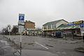
 Bus station
 -
 Shops in Kobeliaky
 -
 Seal of Kobeliaky Company of the Dnieper Pikeman Regiment (Russian Empire)
 -
 People's Actor of Ukraine Stepan Shkurat (from film "Chapayev", 1934)


References
- ^ Ukrainian Zip Codes
- ^ Как расшифровываются новые номера
- ^ Чисельність наявного населення України на 1 січня 2021 [Number of Present Population of Ukraine, as of January 1, 2021] (PDF) (in Ukrainian and English). Kyiv: State Statistics Service of Ukraine.
- ^ "World Meteorological Organization Climate Normals for 1981–2010". World Meteorological Organization. Archived from the original on 17 July 2021. Retrieved 17 July 2021.
External links
- Kobeliaky
- Photogallery of the Kobeliaky city
- History of Kobeliaky city (in Ukrainian language)
- The murder of the Jews of Kobeliaky during World War II, at Yad Vashem website.
This article about a location in Poltava Oblast is a stub. You can help Wikipedia by expanding it. |