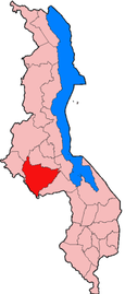
Lilongwe District
This article has multiple issues. Please help improve it or discuss these issues on the talk page. (Learn how and when to remove these messages)
|

Lilongwe is a district in the Central Region of Malawi. The capital is Lilongwe.
The district covers an area of 6,159 km2 (2,378 sq mi) and has a population of 1,346,360. Lilongwe was officially declared a township in 1947. Life President Ngwazi Hastings Kamuzu Banda declared Lilongwe the capital city of Malawi on January 1, 1975 after a ten-year building period during which many people were forcibly displaced to make way for the new government buildings. Prior to 1975, the capital was the much smaller southern city of Zomba. Lilongwe is located 1,050 metres (3,440 ft) above sea level and has a temperature range between 65–75 °F (18–24 °C).
The airport is very small but quite adequate. It is served by Kenya Airways out of Nairobi, South African Airways, proflight, Fastjet and Ethiopian Airways. In 2014 the government of Malawi relaunched its national airline and flies regionally to destinations like Dar es Salaam and Lusaka
Demographics
At the time of the 2018 Census of Malawi, the distribution of the population of Lilongwe District by ethnic group was as follows:[1]
- 94.5% Chewa
- 2.1% Ngoni
- 1.5% Yao
- 1.0% Lomwe
- 0.4% Tumbuka
- 0.1% Sena
- 0.1% Mang'anja
- 0.1% Tonga
- 0.0% Nyanja
- 0.0% Nkhonde
- 0.0% Lambya
- 0.0% Sukwa
- 0.1% Others
Government and administrative divisions
There are twenty-two National Assembly constituencies in Lilongwe:
- Lilongwe - Central
- Lilongwe - City Central
- Lilongwe - City North
- Lilongwe - City South-East
- Lilongwe - City South-West
- Lilongwe - City West
- Lilongwe - East
- Lilongwe - Kumachenga
- Lilongwe - Mapuyu North
- Lilongwe - Mapuyu South
- Lilongwe - Mpenu
- Lilongwe - Mpenu Nkhoma
- Lilongwe - Msinja North
- Lilongwe - Msinja South
- Lilongwe - Msozi North
- Lilongwe - Msozi South
- Lilongwe - North
- Lilongwe - North East
- Lilongwe - North West
- Lilongwe - South
- Lilongwe - South East
- Lilongwe - South West
Since the 2009 election all of these constituencies have been held by members of the Malawi Congress Party.[2]
References
- ^ 2018 Malawi Population and Housing Census Main Report
- ^ "Parliament of Malawi - Members of Parliament - Lilongwe District". Archived from the original on 2016-06-03. Retrieved 2016-05-03.
14°00′S 33°35′E / 14.000°S 33.583°E
