
Mithapukur Upazila
Mithapukur
মিঠাপুকুর | |
|---|---|
 Mithapukur Location in Bangladesh | |
| Coordinates: 25°32.5′N 89°17′E / 25.5417°N 89.283°E | |
| Country | |
| Division | Rangpur Division |
| District | Rangpur District |
| Area | |
| • Total | 515.62 km2 (199.08 sq mi) |
| Population (2011) | |
| • Total | 508,133 |
| • Density | 990/km2 (2,600/sq mi) |
| Time zone | UTC+6 (BST) |
| Website | Official Website of Mithapukur |
Mithapukur (মিঠাপুকুর Mithapukur [ˈmiʈʰaˌpukur] ⓘ) is an upazila of Rangpur District[1] in the division of Rangpur, Bangladesh. The upazila is situated in the middle of Rangpur, surrounded by Rangpur Sadar to the north, Pirganj to the south, Badarganj and Phulbari to the west and Pirgachha and Sundarganj to the east. Mithapukur is famous for being the birthplace of Begum Rokeya Sakhawat Hossain and its sweet mango Harivanga.
Etymology
Mithapukur is the largest upazila in Rangpur zila in respect of both area and population. It came into existence in 1885 as a thana and was upgraded to upazila in 1983. Nothing is definitely known about the origin of the upazila name. It is said that Mir Jumla II, the Subahdar of Bengal, came there by the order of the Mughal Emperor Aurangzeb in order to invade Koch Bihar.[2] He set up a camp near the current Mithapukur Degree College during the period of his military expedition in Bengal. His forces faced an acute problem of water for which a pond was dug near the camp. The water of the pond was so sweet that Mir Jumla named the place "Mithapukur" (Mitha means Sweet and Pukur means Pond). Some believe that Shah Ismail Ghazi ordered to dig the pond. It is believed that the pond consisted of five separate ponds. But in course of time, they mixed into a single pond.[citation needed]

The name Mithapukur also appears in the James Rennell's Dury Wall Map of Bihar and Bengal, India (as Mettypukre) and N. Hindostan Map (as Mettypokra) and John Bartholomew's Map of Provinces of the Lower Ganges (as Mitapokhar).
Geography
Mithapukur is located at 25°32′30″N 89°17′00″E / 25.5417°N 89.2833°E. It has total area 515.62 km2. Mithapukur possesses a vast fertile land. The Jamuneshwari, Akhira, and Ghaghot are the major river flow through Mithapukur. The river, Akhira has divided Mithapukur landscape into two parts. The western part of Mithapukur is locally known as "Khiyari" (probably derived from the word "khoyeri" meaning reddish brown) due to its reddish-brown soil and the eastern part is known as "Poly" (= sediment) area. The eastern part is the largest. Mithapukur is inside the Varendra area. Many "Shalbon" (a forest whose main tree is the Shala tree) can be found in the western part of the Upazila which are thought to be the parts of a huge Varendra forest. Most of them are now reserved by the government. The Gopalpur Forest is the main landmark of Terrace soil area.
Demographics
As of the 2011 Bangladesh census,[3] Mithapukur has a population of 5,08,133 where males constitute 2,52,325 and females constitute 2,55,807 of the population with annual population growth rate of 1.21%. The total number of household of Mithapukur is 1,35,073. Mithapukur has an average literacy rate of 46% (7+ years) compared to the national average of 51.8% literate and 2nd highest literacy rate among the upazila Rangpur district followed by Rangpur Sadar.[3]
Mithapukur Upazila has a very diverse population with minority groups including Buddhists, Christians and tribes such as Santhal who have lived in the district from the beginning of settlement in this area.[4]
Economy

Agriculture is demographically the broadest economic sector and plays a significant role in the overall socio-economic fabric of Mithapukur. Mithapukur is the largest producer of mangoes, vegetables and potatoes in the district. Mithapukur is the birthplace of the sweet mango Harivanga, famous for its different taste.
Points of interest
Mithapukur Upazila has many historical and attractive places. Begum Rokeya Memorial in Pairaband is the birthplace of Begum Rokeya Sakhawat Hossain (1880–1932), an eminent educationist and a pioneer of women's liberation. Mithapukur's most popular tourist attractions are the Mithapukur Pond (excavated during the Mughal period), Benubon Buddhist Vihara-Mithapukur, the Mughal era three domed Mithapukur Mosque, Tanka jami Mosque at Latibpur, and Gopalpur forest and Eco park.[5]
-
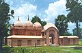 Mithapukur Mughal Era Mosque
 -
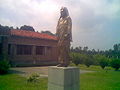 Statue of Begum Rokeya near Begum Rokeya Memorial


Administration
Mithapukur Upazila is divided into Badarganj Municipality and 17 union parishads: Balarhat, Balua Masimpur, Barabala, Bara Hazratpur, Bhangni, Chengmari, Durgapur, Emadpur, Gopalpur, Kafrikhal, Khoragachh, Latibpur, Milanpur, Mirzapur, Moyenpur, Pairaband, and Ranipukur. The union parishads are subdivided into 310 mauzas and 315 villages.[6]
Relating to Education
Educational Institutions
(a) Primary Schools: 268 (B) Lower secondary schools: 20 (C) Secondary schools: 85 (D) Madrasas: 52 (E) Technical schools and colleges: 5 (F) Kinder Garden: 35 (G) Ibtedayi Madrasa: 50 (H) BRAC Primary School: 39 (I) Colleges: 16
Education
There are many educational institutions in Mithapukur, including a few degree colleges.
Primary Education Center
- Paglarhat Mangushree Government Primary School
- Akabpur Government Primary School
High schools
- Arifpur Junior School
- Adarsha High School Mithapukur
- Akhirahat Collegiat High School
- Al-farooque Institute (high School)
- Bairati Junior Girls School Adarhat Adarsha High School
- Balar Hat Model Junior School
- Balarhat High School
- Balua Junior Girls High School
- Bander Para Junior School
- Betgara Junior School
- Bhagabatipur High School
- Bhagobatipur Uttarpara High School
- Bhktipur High School
- Birahimpur Adarsha High School
- Bujruk Tajpur Abarsha High School
- Burail Adorsha Junior School Bairati Bl High School
- Buzruk Mohodipur Girls High School
- Buzruk S. A. High School
- Chadpara Nurani Jr School
- Chalk Bazar Jonior School
- Chuhar High School
- Dhap Bagashory Junior School
- Durgamoti Junior Girls School
- Durgapur High School
- Emadpur Bilateral High School
- Fakirhat Public High School
- Fariudpur High School
- Formuder Para Junior School
- Girai High School
- Gopal Pur High School
- Gopalpur Hamidia High School
- Hulashuganj Bl High School
- Ideal Publik School
- Imadpur Popschim Para High School
- Jaigir High School & College
- Jalal Ganj High School
- Jamal Pur Farida Begum High School
- Jankipur High School
- Jarullapur Girls High School
- Jarullapur High School
- Kashimpur Junior School
- Keshobpur High School
- Khoragach M.l High School
- Khordashan Tipur Junior School
- Kumarganj High School
- Mahiapur Junior High School
- Matherpur Junior School
- Miarhat Ideal Junior High School
- Mirzapur Adarsha School And College
- Mirzapur Girl's High School
- Mirzapur High School
- Mithapukur Girls High School
- Mithapukur High School
- Molong Junior Girl's High School
- Moulovi Ganj High School
- Moyenpur High School
- Moyenpur Kadamtala Bl High School
- Murad Darpa Narayan Pur Junior School
- Muradpur Jr High School
- Nanakar Girl's High School
- Nankar Bilateral High School
- Natibpur B. L .high School
- Nidhirampur Junior Girls School
- Nishchintapur Samiunnessa Girls High School
- Noorpur Girl's High School
- Ovirampur Junior High School
- Padagonj High School & College
- Padmapukur High School
- Paglarhat Monjusree High School
- Paikan High School
- Pairabond B R M Girl's High School
- Pirarhat Junior High School
- Radha Krishnopur High School
- Rahamotpur Junior Girls School
- Ramnather Para Junior High School
- Ranipukur High School And College
- Rasul Pur Junior School
- Ratia High School
- Rupshi High School
- Sahid Zia Saran Girls High School
- Saifur's English School
- Salipur High School
- Samina Khatun Girls High School
- Saran B/l High School
- Satani Raghabandropur High School
- Sathibari Girls High School
- Shah Abul Kashem High School
- Shal Mara Bl High School
- Shaltirhat Bl.high School
- Sherpur High School
- Sherudanga Adarsha Jr.girls High School
- Sherudanga School And College
- Shital Gari High School
- Shthibari M.l High School
- Shukurer Hat High School
- Talimgonj Junior High School
- Tanka Girls Bi Lateral High School
- Thakur Bari Girls School
Madrasas
- Alipur Islamia Dakhil Madrasha
- Bairati Rahmania Dakhil Madrasha
- Balarhat Hamidia Alim Madrasha
- Bara Hazaratpur Dakhil Madrasah
- Batason Islamia Dakhil Madrasha
- Bhaktipur Mahbubia Dakhil Madrasah
- Bhangni Ahmadia Fazil Madrasa
- Buzrug Sontoshpur K.fazil Madrasa
- Chandoni Chandpur Dakhil Madrasha
- Charan Adarsah Girls Dakhil Madrasah
- Chatra Ahmadia Dhakhil Madrasah
- Chharan Bahrul Ulum Alim Madrasah
- Dhap Shampur K.s.d Madrasha
- Emadpur F. U. Fazil Madrasha
- Enayetpur Islamia Dakhil Madrasha
- Faridpur Abdullah Dakhil Madrasah
- Faridpur Mollapara Aminia Dakhil Madrasha
- Guttibari Islamia Fazil Madrasha
- Hulashu Ganj Rashidia Girls Dakhil Madrasha
- Jadabpur Islamia Dakhil Madrasha
- Jafarpur Dakhil Madrasha
- Jaigir Hat Fakhrul Ulum Senior Madrasha
- Jointipur Pirosthan Dakhil Madrasha
- Jorgas Moinpur Dakhil Madrasha
- Kagzipara Ashrafia Dakhil Madrasah
- Keshobpur Nezamia Dakhil Madrasah
- Khordakomarpur Islamia Girls Dakhil Madrasha
- Kumorganj Rahmania Dakhil Madrasha
- Lashkarpur Ashkia Dakhil Madrasah
- Madarpur E.a. Dakhil Madrasha
- Mazgram Darul Huda Dakhil Madrasha
- Milonpur Modinatul Ulum Dakhil Madrasha
- Mirzapur Quaderia Senior Fazil Madrasa
- Mithapukur Dakhil Madrasah
- Molong Shihab Sairaj Dakhil Madrasha
- Muradpur Razzakia Alim Madrasha
- Mushapur Dakhil Madrasah
- Nankor Dakhil Madrasha
- Nayanpur Dakhil Madrasah
- Nidhirampur Girls Dakhil Madrasa
- Pacharhat Dakhil Madrasah
- Paglar Hat Dakhil Madrasha
- Pairaband S. Dakhil Madrasha
- Ramrayer Para Islamia Dakhil Madrasha
- Rokaniganj Ahya Ul-ulum Dakhil Madrasah
- Rupshi Chetanaganj Rahmania Dakhil Madrasah
- Shadullapur Baharul Ulum Dakhil Madrasha
- Shalthi Para Pirsthan Dakhil Madrasah
- Shathi Bari Islamia Senior (alim) Madrasa
- Sherudanga Darul Ulum Dakhil Madrasha
- Sukurerhat Islamia Bilateral Alim Madrasha
- Tarfshadi Khairul Ulum Dakhil Madrasah
Colleges of Mithapukur
- Payraband Government Begum Rokeya Memorial Degree College,
- Jaigir High School and College,
- Mithapukur College,
- Shatibari College,
- Ranipukur High School and College,
- Padaganj School and College
- Akhirahat College,
- Shukurerhat College
- Scatter College
- Bairati College
- Mirzapur Bachir Uddin College
- Balarhat College
- Balarhat Adarsh College
- Henna Memorial Women's College
- Serudanga School and College.
- Mirzapur Adarsh High School and College.
Transport
Mithapukur is well connected to Dhaka, Rangpur, Bogra by National highway. Mithapukur can be reached by the 304 km long National highway(N5) from Dhaka. The highway also provides a link to the neighbouring divisional town Rangpur by 18 km from Upazila Sadar. Highway buses run from kallanpur, Dhaka to Rangpur and it takes about six to seven hours.
Notable residents
- Begum Rokeya Sakhawat Hossain, writer, educationist, and social activist, was born in Pairaband in 1880.[7]
- H.N.Ashequr Rahman Bangladesh Awami League politician and Incumbent Member of Parliament
- Dr.Rashid Askari, Bengali-English writer, fictionist, columnist, translator, professor of English and the 12th vice-chancellor of Islamic University, Bangladesh[8]
See also
References
- ^ Abu Md. Iqbal Rumi Shah (2012). "Mithapukur Upazila". In Sirajul Islam and Ahmed A. Jamal (ed.). Banglapedia: National Encyclopedia of Bangladesh (Second ed.). Asiatic Society of Bangladesh.
- ^ Col Ved Prakash (2006). "Ahom Rule: Last Two Centuries". Encyclopaedia of North-East India, Volume 1 (hardcover ed.). Atlantic Publishers & Distributors (P) Ltd. ISBN 978-8126907038.
- ^ a b "Population & Housing Census 2011: Community Report of Rangpur" (PDF). BBS. Archived from the original (PDF) on 2014-11-13. Retrieved 2015-09-12.
- ^ Abdus Sattar (2012). "Rangpur District". In Sirajul Islam and Ahmed A. Jamal (ed.). Banglapedia: National Encyclopedia of Bangladesh (Second ed.). Asiatic Society of Bangladesh.
- ^ দর্শনীয় স্থান [Sightseeing]. Mithapukur Upazila (in Bengali). Bangladesh National Portal.
- ^ "District Statistics 2011: Rangpur" (PDF). Bangladesh Bureau of Statistics. Archived from the original (PDF) on 13 November 2014. Retrieved 14 July 2014.
- ^ Akhter, Shahida (2012). "Hossain, Roquiah Sakhawat". In Islam, Sirajul; Jamal, Ahmed A. (eds.). Banglapedia: National Encyclopedia of Bangladesh (Second ed.). Asiatic Society of Bangladesh.
- ^ "Dr. Rashid Askari". Retrieved 2019-04-12.
| Upazila/Thana: | ||
|---|---|---|