List of numbered roads in Kingston and Frontenac County

From Wikipedia, the free encyclopedia
(Redirected from Ontario Highway 506)

This is a list of numbered municipal roads in Kingston and Frontenac County, Ontario.

The City of Kingston is a single-tier municipality not under the jurisdiction of an upper-tier municipality such as Frontenac County and thus, is outside of the geographic limits of Frontenac County for municipal purposes. For geographic purposes however, Kingston is within the geographic limits of Frontenac County.[1] The City of Kingston forms part of the county's census division.

The numbered roads in this list are not under the jurisdiction of Frontenac County (only their numbers are, for coordination[citation needed]); the responsibility for their maintenance is with the individual townships (and City of Kingston).[2] As a result, the "flowerpot" municipal road shields are signed with the name of the township, such as Central Frontenac, Kingston or Wolfe Island (for Frontenac Islands Township). South Frontenac Township makes reference to its numbered township highways as Township Road n in law.[3]
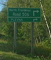
Main List[edit]

Route(s)[3] Name[3] West/South Terminus[3] East/North Terminus[3] Communities Comments
Kingston Road 1
Front Road Lemoine Point King Street West Kingston
Princess Street
Highway 2
Kingston Formerly Highway 2
Kingston Road 3
Unity Road Kingston Road 11 Elginburg, Glenburnie
South Frontenac Township Road 4
Yarker Road  Township Road 38
South Frontenac Township Road 5
Harrowsmith Road Harrowsmith
South Frontenac Township Road 7
Bellrock Road  Township Road 38 Verona
South Frontenac Township Road 8
Westport Godfrey, Fermoy
Kingston Road 9

South Frontenac Township Road 9
Sydenham Road Princess Street Kingston, Sydenham
Kingston Road 10

South Frontenac Township Road 10
Division Street
Perth Road
Kingston, Westport
Kingston Road 11

South Frontenac Township Road 11
Battersea Road Kingston, Battersea Continues as Montreal Street in Kingston.
Kingston Road 12

South Frontenac Township Road 12
Highway 15
Kingston Road 13
Continues as  County Road 13 Highway 15
Highway 15  Highway 2 Highway 401 Kingston Continues as Highway 15
Kingston Road 16
Joyceville Road  Highway 2  Highway 15 Joyceville
Kingston Road 17
Days Road Front Road Bath Road Kingston
South Frontenac Township Road 18
Wilton Road Harrowsmith
South Frontenac Township Road 19
Canoe Lake Road Fermoy
Kingston Road 23
Taylor-Kidd Boulevard Kingston
Kingston Road 25
Bayridge Drive Kingston
Bath Road Princess Street Kingston Formerly Highway 33; part of Loyalist Parkway
Kingston Road 38

South Frontenac Township Road 38

Central Frontenac Township Road 38
Gardiners Road Bath Road Highway 7 Kingston, Verona, Sharbot Lake Formerly Highway 38
Frontenac Islands Township Road 95
Highway 95 Wolfe Island Ferry Dock, Marysville Point Alexandria Marysville, Wolfe Island Formerly Highway 95
Frontenac Islands Township Road 96
Highway 96 Sand Bay Road Port Metcalf Scotch Settlement, Wolfe Island Formerly Highway 96
North Frontenac Township Road 506
Road 506 Highway 41 North Frontenac Road 509 Formerly Highway 506
Central Frontenac Township Road 509

North Frontenac Township Road 509
Road 509 Highway 7 North Frontenac Road 506 Clarendon, Snow Road, Ompah Formerly Highway 509

References[edit]

  1. ^ O. Reg. 180/03: DIVISION OF ONTARIO INTO GEOGRAPHIC AREAS, s. 2, Government of Ontario, retrieved 2020-06-24
  2. ^ Roads and Bridges, County of Frontenac, archived from the original on 2019-04-23, retrieved 2019-04-23
  3. ^ a b c d e The Corporation of the Township of South Frontenac, By-Law 2000-01 (PDF), archived from the original (PDF) on 2019-06-30, retrieved 2019-06-30