
Oosterland, Zeeland
Oosterland | |
|---|---|
Village | |
 Farm in Oosterland | |
 Coat of arms | |
 Oosterland Location in the province of Zeeland in the Netherlands  Oosterland Oosterland (Netherlands) | |
| Coordinates: 51°38′58″N 4°2′8″E / 51.64944°N 4.03556°E | |
| Country | Netherlands |
| Province | Zeeland |
| Municipality | Schouwen-Duiveland |
| Area | |
| • Total | 13.45 km2 (5.19 sq mi) |
| Elevation | 0.0 m (0.0 ft) |
| Population (2021)[1] | |
| • Total | 2,310 |
| • Density | 170/km2 (440/sq mi) |
| Time zone | UTC+1 (CET) |
| • Summer (DST) | UTC+2 (CEST) |
| Postal code | 4307[1] |
| Dialing code | 0111 |
Oosterland is a village in the south-west Netherlands. It is located in the municipality of Schouwen-Duiveland, Zeeland, about 22 km south of Hellevoetsluis.
History
[edit]The village was first mentioned in 1370 as "den ambochte in Oesterer Nuwelant in Duvelant", and means "eastern (polder) land". In 1353, permission was granted to enclose the area with a dike.[3] Oosterland is a road village which developed after 1354.[4]
The Dutch Reformed church has a detached tower from the 14th century, because the original church burnt down in 1612. The tower burnt down in 1945 and was rebuilt between 1948 and 1950.[4] The grist mill of Oosterland was built in 1752. The windmill went out of service after the North Sea flood of 1953. It was restored between 1957 and 1959, and remained in operation until 1965. Since 2017, the windmill has been back in service.[5]
Oosterland was home to 917 people in 1840. The village was bombed in 1945.[6] A large part of the village was destroyed during the North Sea flood of 1953 and later rebuilt further north.[4]
Oosterland was a separate municipality until 1961, when the new municipality of Duiveland was created.[7] In 1997, it became part of the municipality of Schouwen-Duiveland.[6]
Gallery
[edit]-
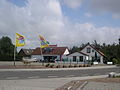 Restaurant in Oosterland
 -
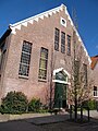
 Former town hall
 -
 Reformed church
 -
 Windmill: Oosterlandse molen


References
[edit]- ^ a b c "Kerncijfers wijken en buurten 2021". Central Bureau of Statistics. Retrieved 21 April 2022.
two entries
- ^ "Postcodetool for 4307AA". Actueel Hoogtebestand Nederland (in Dutch). Het Waterschapshuis. Retrieved 21 April 2022.
- ^ "Oosterland - (geografische naam)". Etymologiebank (in Dutch). Retrieved 21 April 2022.
- ^ a b c Piet van Cruyningen & Ronald Stenvert (2003). Oosterland (in Dutch). Zwolle: Waanders. ISBN 90 400 8830 6. Retrieved 21 April 2022.
- ^ "(stenen grondzeiler)". Molen database (in Dutch). Retrieved 21 April 2022.
- ^ a b "Oosterland". Plaatsengids (in Dutch). Retrieved 21 April 2022.
- ^ Ad van der Meer and Onno Boonstra, Repertorium van Nederlandse gemeenten, KNAW, 2011.