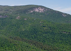
Porter Mountain
| Porter Mountain | |
|---|---|
 Porter Mountain from Rooster Comb Mountain | |
| Highest point | |
| Elevation | 4,059 feet (1,237 m)[1] |
| Prominence | 330 ft (100 m)[2] |
| Listing | Adirondack High Peaks |
| Coordinates | 44°12′55″N 73°50′37″W / 44.21528°N 73.84361°W |
| Geography | |
| Location | Keene, New York, U.S. |
| Parent range | Adirondacks |
| Topo map | USGS Keene Valley |
| Climbing | |
| First ascent | 1875 by Ed Phelps and Noah Porter |
| Easiest route | Hike |
Porter Mountain is in Essex County of New York. It is one of the 46 Adirondack High Peaks and is located in the Adirondack Park. Its name comes from Noah Porter, later president of Yale University and one of the first to climb it.
Somewhat overshadowed by its higher and more popular neighbor, Cascade Mountain, with which it is often climbed, Porter is nevertheless rewarding. While it lacks the pseudo-alpine open summit of Cascade, there are nevertheless wide views available from the summit, particularly of the Johns Brook Valley to the east (which Porter blocks from Cascade); it is often less crowded than Cascade.
A yellow-blazed trail leaves the trail to Cascade about 0.5 mile (approximately 1 km) short of that mountain's summit, and leads down into the col between the two peaks about 1 mile (1.6 km) to Porter’s summit.
It is also possible to follow this trail from its other terminus, over neighboring Blueberry Mountain from Keene Valley, although that involves a greater vertical ascent and a longer trip. The trailhead to Blueberry Mountain and subsequently Porter Mountain is accessible from a parking lot next to Marcy Airfield on route 73.
Notes
External links
- U.S. Geological Survey Geographic Names Information System: Porter Mountain
- Peakbagger.com: Porter Mountain
- Summitpost.org: Porter Mountain
