
Shangchuan Island
.jpg)
Shangchuan Island (Chinese: 上川岛; pinyin: Shàngchuāndǎo, also known as "Schangschwan", "Sancian", "Sanchão", "Chang-Chuang", "St. John's Island" or "St John Island"[1]) is the main island of Chuanshan Archipelago on the southern coast of Guangdong, China. Its name originated from São João ("Saint John" in Portuguese).[2]
Administratively, it is a part of Chuandao (川岛镇), Taishan. Located 14 kilometers (8.7 mi) from the mainland, it became the largest island in Guangdong after Hainan Island was carved out of the province in 1988.
The area of the island is 139.87 square kilometers (54.00 sq mi), and has a population of 16,320.
It is known for having been the place of death of St. Francis Xavier. Nowadays, it is a tourist site in Guangdong.
History

Shangchuan Island was one of the first bases established by the Portuguese off the China coast, during the 16th century. They abandoned this base after the Chinese government gave consent for a permanent and official Portuguese trade base at Macau in 1557.
The Spanish (Navarre) Jesuit missionary St. Francis Xavier died on the island on December 3, 1552, as he was waiting for a ship to take him to mainland China. There is a small chapel that commemorates his death place, designed by Achille-Antoine Hermitte and completed in 1869.[3]
Geography
The island has been isolated from the mainland since the last ice age. It is located near Xiachuan Island, which lies west of Shangchuan. The two islands, together with smaller islets, form Chuanshan Archipelago.
Shangshuan Island has an area of 137.3 km2 and a 217 km coastline.
Climate
| Climate data for Shangchuan Island (1981−2010) | |||||||||||||
|---|---|---|---|---|---|---|---|---|---|---|---|---|---|
| Month | Jan | Feb | Mar | Apr | May | Jun | Jul | Aug | Sep | Oct | Nov | Dec | Year |
| Record high °C (°F) | 27.2 (81.0) |
27.9 (82.2) |
29.6 (85.3) |
31.9 (89.4) |
35.0 (95.0) |
35.4 (95.7) |
37.0 (98.6) |
35.9 (96.6) |
35.9 (96.6) |
33.1 (91.6) |
31.7 (89.1) |
28.2 (82.8) |
37.0 (98.6) |
| Mean daily maximum °C (°F) | 18.6 (65.5) |
19.2 (66.6) |
21.9 (71.4) |
25.6 (78.1) |
28.9 (84.0) |
30.5 (86.9) |
31.5 (88.7) |
31.5 (88.7) |
30.5 (86.9) |
28.0 (82.4) |
24.3 (75.7) |
20.3 (68.5) |
25.9 (78.6) |
| Daily mean °C (°F) | 15.4 (59.7) |
16.2 (61.2) |
18.9 (66.0) |
22.8 (73.0) |
26.0 (78.8) |
27.9 (82.2) |
28.5 (83.3) |
28.3 (82.9) |
27.4 (81.3) |
25.0 (77.0) |
21.1 (70.0) |
17.0 (62.6) |
22.9 (73.2) |
| Mean daily minimum °C (°F) | 13.1 (55.6) |
14.2 (57.6) |
16.8 (62.2) |
20.8 (69.4) |
24.0 (75.2) |
25.8 (78.4) |
26.2 (79.2) |
25.9 (78.6) |
25.1 (77.2) |
22.8 (73.0) |
18.7 (65.7) |
14.6 (58.3) |
20.7 (69.2) |
| Record low °C (°F) | 4.1 (39.4) |
4.2 (39.6) |
4.1 (39.4) |
10.4 (50.7) |
16.2 (61.2) |
20.3 (68.5) |
22.0 (71.6) |
21.8 (71.2) |
17.7 (63.9) |
13.1 (55.6) |
6.4 (43.5) |
3.8 (38.8) |
3.8 (38.8) |
| Average precipitation mm (inches) | 23.6 (0.93) |
49.3 (1.94) |
66.5 (2.62) |
176.1 (6.93) |
318.9 (12.56) |
388.3 (15.29) |
305.0 (12.01) |
391.6 (15.42) |
301.9 (11.89) |
132.7 (5.22) |
46.2 (1.82) |
29.9 (1.18) |
2,230 (87.81) |
| Average relative humidity (%) | 76 | 83 | 85 | 87 | 85 | 85 | 84 | 84 | 81 | 76 | 72 | 70 | 81 |
| Source: China Meteorological Data Service Center[4] | |||||||||||||
Economy
Shangchuan and Xiachuan have been established as a Tourism Open Integrated Experimental Zone (旅游开发综合试验区, pinyin: lǚyóu kāifā zōnghé shìyàn qū).
Feisha Beach Resort (飞沙滩旅游区) is a commercial tourist resort located on the island's eastern shore.
Transportation
Shangchuan Island is linked by ferry to Guanghai, Haiyan (Shanju) and Xiachuan Island.
See also
- Chuanshan Archipelago
- Tamão, Lampacau, Shuangyu
- List of islands of the People's Republic of China
- List of islands in the South China Sea
- List of Jesuit sites
Notes and references
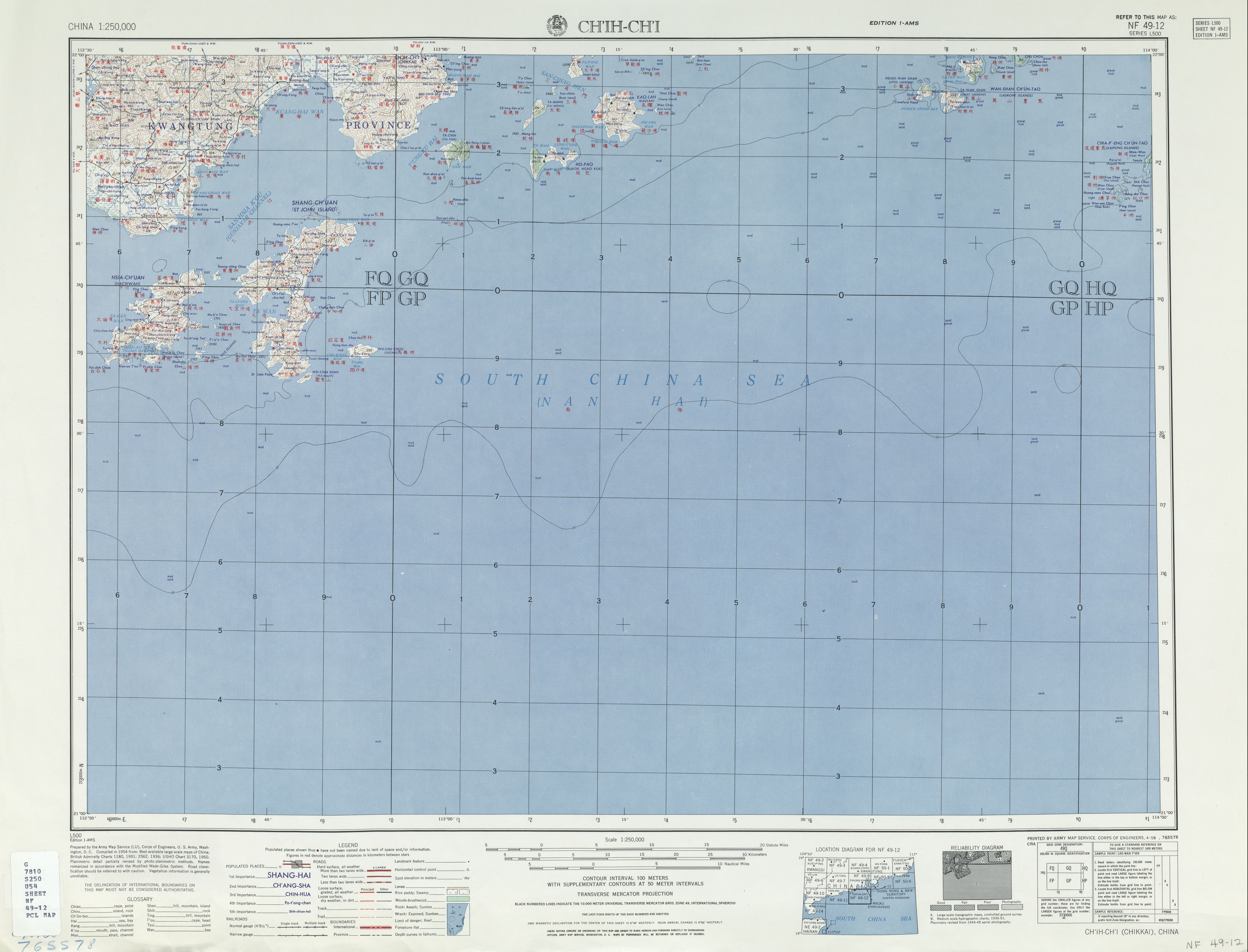
- ^ "NF 49-12 CH'IH-CH'I" (in English and Chinese). Washington, D. C.: Army Map Service. 1954 – via Perry–Castañeda Library Map Collection.
SHANG-CH'UAN (ST JOHN ISLAND) 上川
- ^ Gunn, Geoffrey C. World trade systems of the East and the West : Nagasaki and the Asian bullion trade networks. ISBN 978-90-04-35856-0. OCLC 1007502712.
- ^ Davies, Stephen; 戴偉思 (2016), "Achille-Antoine Hermitte's Surviving Building / 阿基里‧ 安當‧ 埃爾米特的倖存建築", Journal of the Royal Asiatic Society Hong Kong Branch, 56, Royal Asiatic Society Hong Kong Branch: 98, JSTOR jroyaaisasocihkb.56.92
- ^ 中国地面气候标准值月值(1981-2010) (in Simplified Chinese). China Meteorological Data Service Center. Retrieved 7 November 2022.
Further reading
- Guillemin, Philippe François Zéphirin (1870). Lettres sur l'erection de la chapelle de S. François Xavier dans l'île de Sancian et autres faits récents de la mission (in French). Rome: Imprimerie de la Propagande, P. Marietti.
External links
General
- Stuckey, Peter; Bailey, Chris (2002). "Visiting St. John's Island" (PDF). Journal of the Royal Asiatic Society Hong Kong Branch. 42: 435–448. ISSN 1991-7295.
- Satellite view on Google Maps
- Website about Shangchuan (in Chinese and English)
- Shangchuan on taishan.com (in English)
- on tsinfo.com.cn (in English)
- Pictures of the island (click on the links on the left to view more)