
South Karelia
South Karelia
Etelä-Karjalan maakunta Södra Karelens landskap | |
|---|---|
 Coat of arms | |
 South Karelia on a map of Finland | |
| Country | Finland |
| Historical province | Karelia |
| Area | |
| • Total | 7,235.59 km2 (2,793.68 sq mi) |
| Population (2011) | |
| • Total | 132,252 |
| • Density | 18/km2 (47/sq mi) |
| ISO 3166 code | FI-02 |
| NUTS | FI187 |
| Regional bird | Thrush nightingale |
| Regional fish | Lake salmon |
| Regional flower | Spring pasque flower |
| Website | Etelä-Karjala |
South Karelia (Finnish: Etelä-Karjala; Swedish: Södra Karelen) is a region of Finland. It borders the regions of Kymenlaakso, Southern Savonia and North Karelia, as well as Russia.
Historical province
For History, Geography and Culture see: Karelia
Regional Council
Municipalities
South Karelia is divided into ten municipalities. Two of these are cities.
Heraldry
The coat of arms of South Karelia is composed of the arms of Karelia.
Gallery
-
 Imatrankoski Rapids, largest in Europe
 -
 Uukuniemi Church
 -
 Lappeenranta harbour
 -
 Countryside of Lappeenranta
 -
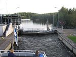 On a boat in a lock on Saimaa Canal
 -
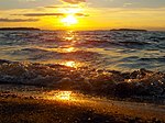 On the shore of Lake Saimaa, Finland's largest lake
 -
 Luumäki Church
 -
 The Salpa-Line in Lappeenranta
 -
 Pulsa train station, Lappeenranta
 -
 Vaaranmäki, Saari
 -
 Ruokolahti Bell Tower
 -
 Lake Simpelejärvi
 -
 Restaurant Kägöne in style of a Border-Karelian house, Parikkala
 -
 Suomenniemi Church
 -
 Haukkavuori in Rautjärvi
 -
 Saari Church
 -
 Imatra State Hotel
 -
 Kotkaniemi in Luumäki, former home of President Svinhufvud, now museum
 -
 A wintery rural landscape in Lappeenranta
 -
 Kärnäkoski Fortress in Savitaipale
 -
 River Vuoksi is dry most of the time at Imatrankoski Rapids; the power plant was built in 1920s
 -
 Parikkala Church
 -
 Fortification, Lappeenranta
 -
 Church of the Three Crosses by Alvar Aalto in Imatra


External links
Wikimedia Commons has media related to South Karelia.
| Regions |  | |
|---|---|---|
| Former regions | ||