
Strâmtura
This article needs additional citations for verification. (August 2008) |
Strâmtura | |
|---|---|
 Strâmtura village | |
 Location in Maramureș County | |
 Strâmtura Location in Romania | |
| Coordinates: 47°46′20″N 24°08′10″E / 47.77222°N 24.13611°E | |
| Country | Romania |
| County | Maramureș |
| Government | |
| • Mayor (2020–2024) | Ioan Pasere (PNL) |
| Area | 91.57 km2 (35.36 sq mi) |
| Elevation | 336 m (1,102 ft) |
| Population (2021-12-01)[1] | 3,254 |
| • Density | 36/km2 (92/sq mi) |
| Time zone | EET/EEST (UTC+2/+3) |
| Postal code | 437310 |
| Area code | +40 x59 |
| Vehicle reg. | MM |
| Website | comunastramturamm |
Strâmtura (Hungarian: Szurdok, Yiddish: סטרימטערע, romanized: Strimtere) is a commune in Maramureș County, Maramureș, Romania. It is composed of three villages: Glod (Hungarian: Glód), Slătioara (Hungarian: Izasópatak or Szlatina, Yiddish: סלאטינה, romanized: Slatina), and Strâmtura.
The commune is located in the central part of Maramureș County, 66 km (41 mi) northeast of the county seat, Baia Mare. It is situated at an altitude of 336 m (1,102 ft), in a hilly area on the banks of the Iza River and its tributaries, the Slătioara and Valea Satului rivers.
Demographics[edit]
| Year | Pop. | ±% |
|---|---|---|
| 1880 | 3,751 | — |
| 1900 | 4,674 | +24.6% |
| 1910 | 5,129 | +9.7% |
| 1930 | 5,243 | +2.2% |
| 1956 | 5,286 | +0.8% |
| 1977 | 5,237 | −0.9% |
| 1992 | 4,889 | −6.6% |
| 2002 | 4,211 | −13.9% |
| 2011 | 3,652 | −13.3% |
| 2021 | 3,254 | −10.9% |
| Source: Census data | ||
At the 2021 census, Strâmtura had a population of 3,254, with an absolute majority (96%) of ethnic Romanians.[2]
Natives[edit]
- Mihai Pop (1907 – 2000), ethnologist
References[edit]
External links[edit]
-
 Archangels' wooden church in Strâmtura
 -
 Orthodox church in Strâmtura
 -
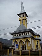 Greek Catholic church in Strâmtura
 -
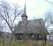 Saint Nicholas' wooden church in Glod


.jpg)

This Maramureș County location article is a stub. You can help Wikipedia by expanding it. |