Sudanell
Appearance
Sudanell | |
|---|---|
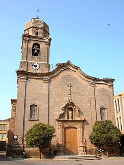
 St. Peter's church | |
| Coordinates: 41°33′N 0°34′E / 41.550°N 0.567°E | |
| Country | |
| Community | |
| Province | Lleida |
| Comarca | Segrià |
| Government | |
| • Mayor | Josep Maria Sanjuan Cornadó (2015)[1] (CIU) |
| Area | |
| • Total | 8.7 km2 (3.4 sq mi) |
| Elevation | 152 m (499 ft) |
| Population (2018)[3] | |
| • Total | 851 |
| • Density | 98/km2 (250/sq mi) |
| Demonym(s) | Sudanellenc, sudanellenca |
| Website | sudanell |
Sudanell is a municipality in the comarca of the Segrià in Catalonia. It is located by the junction of two rivers: the Segre and the Set. Agriculture is Sudanell's principal economic activity (peaches, apples, pears, corn). Two canals: Canal de Seròs and Acèquia de Torres irrigate the area.
Elements of touristic interest
- Cross Head (Creu del Terme). Made from stone and dated from the 14th century.
- Parish church of Sant Pere (Saint Peter). The primitive parish church of Sant Pere, Romanesque, was replaced in the 18th century for an extense Baroque building, with a monumental façade.
- The Muladar. The graves of Muladar constitute the first necropolis excavated in the region of the Segrià.
- The Official town's Holy Day is on the first weekend in October.
References
- ^ "Ajuntament de Sudanell". Generalitat of Catalonia. Retrieved 2015-11-13.
- ^ "El municipi en xifres: Sudanell". Statistical Institute of Catalonia. Retrieved 2015-11-23.
- ^ Municipal Register of Spain 2018. National Statistics Institute.
External links
- Official municipal web site (in Catalan)
- Government data pages (in Catalan)

