
Toyooka, Hyōgo
Toyooka
豊岡市 | |
|---|---|
 Flag  Seal | |
 Location of Toyooka in Hyōgo Prefecture | |
 Toyooka Location in Japan | |
| Coordinates: 35°33′N 134°49′E / 35.550°N 134.817°E | |
| Country | Japan |
| Region | Kansai |
| Prefecture | Hyōgo |
| First official recorded | 655 BC |
| Town settled | April 1, 1889 |
| City settled | April 1, 1950 |
| Government | |
| • Mayor | Muneharu Nakagai |
| Area | |
• Total | 697.55 km2 (269.33 sq mi) |
| Population (October 1, 2023) | |
• Total | 74,268 |
| • Density | 110/km2 (280/sq mi) |
| Time zone | UTC+09:00 (JST) |
| City hall address | 2-4 Chūōmachi, Toyooka-shi, Hyōgo-ken 668-8666 |
| Climate | Cfa |
| Website | Official website |
| Symbols | |
| Bird | Oriental white stork |
| Flower | Tulip |
| Tree | Willow |


Toyooka (豊岡市, Toyooka-shi) is a city in the northern part of Hyōgo Prefecture, Japan. As of 31 March 2022[update], the city had an estimated population of 78,348 in 37769 households and a population density of 110 persons per km2.[1] The total area of the city is 697.55 square kilometres (269.33 sq mi).
Geography
[edit]Toyooka is located in the northern part of Hyōgo Prefecture and the Kinki region, facing the Sea of Japan in the north. It lies entirely within the San'in Kaigan Geopark.[2] The Maruyama River flows through the central part of the city, and the Toyooka Basin, which is the largest basin in the Tajima region, spreads out in the central part of the city. Toyooka is located in the "snow country" of Japan and is characterized by heavy accumulations of snow in winter. One of Toyooka's famous geological features is a basalt cave called Gembudō. Gembudō was formed 1.6 million years ago from the eruption of an ancient volcano. In 1926, Professor Motonori Matuyama of Kyoto University first proposed the theory of geomagnetic polarity reversal at Genbudo after discovering it had a reverse magnetization.
The wetlands of Toyooka provide an important habitat for the oriental stork. After becoming extinct in the wild in the 1970s, Toyooka began a captive breeding program. After a quarter of a century of breeding efforts, the first oriental stork chick was born in 1989. In 2005 Toyooka released 5 captively bred storks, which bred successfully in the wild. As of June 2015 there are 72 wild oriental white storks in Toyooka.
The hot spring resort Kinosaki Onsen is located within Toyooka.
Neighbouring municipalities
[edit]Hyōgo Prefecture
Kyoto Prefecture
Climate
[edit]Kyōtango has a humid climate (Köppen Cfa) characterized by warm, wet summers and cold winters with heavy snowfall.[3] Although part of the Kansai region and Hyōgo Prefecture, Toyooka has a climate much more similar to the Hokuriku region of Chūbu and Tōhoku. Unlike Osaka or Kobe, which rarely see significant snowfall during the winter, Toyooka, exposed to the northerly winter winds driven by the Siberian High and Aleutian Low, receives 3.1 metres (122.0 in) of snowfall per year, though melt rates are high even during the winter and the maximum cover on the ground is typically only 0.35 metres (13.8 in) and has never exceeded 0.54 metres (21.3 in). Precipitation is much heavier than in central Kansai, though less heavy than in the Kii Peninsula or the Hokuriku region proper.
| Climate data for Toyooka (1991−2020 normals, extremes 1918−present) | |||||||||||||
|---|---|---|---|---|---|---|---|---|---|---|---|---|---|
| Month | Jan | Feb | Mar | Apr | May | Jun | Jul | Aug | Sep | Oct | Nov | Dec | Year |
| Record high °C (°F) | 21.4 (70.5) |
23.0 (73.4) |
26.7 (80.1) |
32.2 (90.0) |
33.9 (93.0) |
37.2 (99.0) |
39.3 (102.7) |
39.7 (103.5) |
38.0 (100.4) |
32.4 (90.3) |
27.2 (81.0) |
23.1 (73.6) |
39.7 (103.5) |
| Mean daily maximum °C (°F) | 7.4 (45.3) |
8.4 (47.1) |
13.0 (55.4) |
19.3 (66.7) |
24.3 (75.7) |
27.3 (81.1) |
31.2 (88.2) |
32.8 (91.0) |
27.8 (82.0) |
22.2 (72.0) |
16.5 (61.7) |
10.5 (50.9) |
20.1 (68.1) |
| Daily mean °C (°F) | 3.3 (37.9) |
3.7 (38.7) |
7.2 (45.0) |
12.7 (54.9) |
17.8 (64.0) |
21.8 (71.2) |
26.0 (78.8) |
27.1 (80.8) |
22.6 (72.7) |
16.6 (61.9) |
11.1 (52.0) |
5.9 (42.6) |
14.7 (58.4) |
| Mean daily minimum °C (°F) | 0.4 (32.7) |
0.2 (32.4) |
2.4 (36.3) |
6.9 (44.4) |
12.4 (54.3) |
17.7 (63.9) |
22.3 (72.1) |
23.1 (73.6) |
18.9 (66.0) |
12.6 (54.7) |
7.2 (45.0) |
2.5 (36.5) |
10.6 (51.0) |
| Record low °C (°F) | −12.5 (9.5) |
−11.1 (12.0) |
−11.0 (12.2) |
−3.2 (26.2) |
0.7 (33.3) |
6.0 (42.8) |
13.0 (55.4) |
13.8 (56.8) |
7.9 (46.2) |
2.0 (35.6) |
−2.2 (28.0) |
−9.1 (15.6) |
−12.5 (9.5) |
| Average precipitation mm (inches) | 248.0 (9.76) |
188.0 (7.40) |
150.6 (5.93) |
99.6 (3.92) |
122.1 (4.81) |
150.0 (5.91) |
187.7 (7.39) |
144.5 (5.69) |
243.8 (9.60) |
172.4 (6.79) |
154.6 (6.09) |
227.6 (8.96) |
2,072 (81.57) |
| Average snowfall cm (inches) | 82 (32) |
74 (29) |
14 (5.5) |
trace | 0 (0) |
0 (0) |
0 (0) |
0 (0) |
0 (0) |
0 (0) |
trace | 34 (13) |
204 (80) |
| Average precipitation days (≥ 1.0 mm) | 21.2 | 17.0 | 15.0 | 10.7 | 10.0 | 10.9 | 11.9 | 9.9 | 12.8 | 12.0 | 14.1 | 19.5 | 165 |
| Average snowy days (≥ 1 cm) | 12.5 | 11.3 | 2.9 | 0.1 | 0 | 0 | 0 | 0 | 0 | 0 | 0.1 | 5.7 | 32.6 |
| Average relative humidity (%) | 84 | 81 | 75 | 71 | 71 | 77 | 79 | 76 | 80 | 81 | 82 | 83 | 78 |
| Mean monthly sunshine hours | 65.0 | 75.4 | 116.8 | 164.0 | 186.8 | 138.1 | 150.5 | 189.0 | 123.2 | 115.0 | 90.6 | 72.9 | 1,487.3 |
| Source: Japan Meteorological Agency[4][5] | |||||||||||||
Demographics
[edit]Per Japanese census data, the population of Toyooka in 2020 is 77,489 people.[6] Toyooka has been conducting censuses since 1950.
| Year | Pop. | ±% |
|---|---|---|
| 1950 | 102,838 | — |
| 1955 | 102,557 | −0.3% |
| 1960 | 99,572 | −2.9% |
| 1965 | 96,599 | −3.0% |
| 1970 | 94,732 | −1.9% |
| 1975 | 95,687 | +1.0% |
| 1980 | 96,448 | +0.8% |
| 1985 | 96,086 | −0.4% |
| 1990 | 94,163 | −2.0% |
| 1995 | 93,859 | −0.3% |
| 2000 | 92,752 | −1.2% |
| 2005 | 89,208 | −3.8% |
| 2010 | 85,607 | −4.0% |
| 2015 | 82,250 | −3.9% |
| 2020 | 77,489 | −5.8% |
| Toyooka population statistics[6] | ||
History
[edit]The area of Toyooka was the center of ancient Tajima Province in the early 8th century and the location of the provincial capital and the Tajima Kokubun-ji. From the Muromachi period to the end of the Sengoku period, the area was under the stronghold of the powerful Yamana clan. Under the Edo Period Tokugawa shogunate, Toyooka Domain and Izushi Domain existed within the borders of what is now the city of Toyooka. In 1871, following the Meiji restoration, "Toyooka Prefecture" incorporating all of the former feudal territories within Tajima, Tango and Tanba Provinces was created. It was abolished on August 21, 1876, when Hyōgo Prefecture was created. The town of Toyooka was officially established with the creation of the modern municipalities system on April 1, 1889. The 1925 North Tajima earthquake created severe damage in Toyooka, with official government reports, indicating that there were 428 fatalities, 1,016 injuries, 7,863 buildings destroyed, and 45,659 houses damaged by collapse or fire.[7]
The city of Toyooka was created on April 1, 1950 by the merger of Toyooka with neighboring Gosho, Nitta, and Nakasuji villages. The city expanded on April 1, 1955 by annexing Nasa and Minato villages. On April 1, 2005, the towns of Kinosaki, Hidaka and Takeno (all from Kinosaki District) and the towns of Izushi and Tantō (both from Izushi District) were merged into Toyooka.
Government
[edit]Toyooka has a mayor-council form of government with a directly elected mayor and a unicameral city council of 24 members. Toyooka contributes one member to the Hyogo Prefectural Assembly. In terms of national politics, the city is part of Hyōgo 5th district of the lower house of the Diet of Japan.
Economy
[edit]Toyooka has mostly a rural economy based on agriculture and commercial fishing.
Education
[edit]Toyooka has 22 public elementary schools and nine public middle schools operated by the city government and four public high schools operated by the Hyōgo Prefectural Department of Education. There is also one private middle school and one private high school. The Toyooka Junior College and the Professional College of Arts and Tourism are also located in the city. The prefecture also operates two special education schools for the handicapped.
Transportation
[edit]
Railway
[edit]The Sanin Main Line provides a JR rail connection to Kyoto, and direct trains to Osaka are available via Fukuchiyama. Direct Express trains take about 2.5 hours from Osaka to Toyooka.
![]() Kyoto Tango Railway – Miyazu Line
Kyoto Tango Railway – Miyazu Line
Highways
[edit] Kitakinki-Toyooka Expressway
 National Route 178
 National Route 312
 National Route 426
 National Route 482
 National Route 483
Airport
[edit]Tajima Airport serves Toyooka and its area with two direct flights a day to Osaka Itami Airport
Sister cities
[edit] Ueda, Nagano Prefecture (since the former city of Ueda and the former town of Izushi were sister cities before the recent creation of both Toyooka and Ueda)
 Gyeongju, South Korea
 Alicante, Spain, since 1996
Local attractions
[edit]- Hyōgo Prefectural Stork Nature Park
- Izushi Castle
- Kinosaki Marine World
- Kinosaki Onsen
- Mount Kannabe
- Tajima Kokubun-ji ruins
- Takeno Beach
-
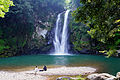 Hattan Falls in Kannabe highlands
 -
 Cherry blossoms in Kinosaki Onsen
 -
 Genbudo cave
 -
 Toyooka City Mascot Gensan
 -
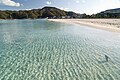 Takeno Beach
 -
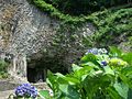
 Izushi Castle Inari Shrine
 -
 Toyooka City Oriental white stork


References
[edit]- ^ "Toyooka city official statistics" (in Japanese). Japan.
- ^ "What is San'in Kaigan Geopark" on the official website of San'in Kaigan Geopark (in Japanese)
- ^ Toyooka climate data
- ^ 平年値(年・月ごとの値) (in Japanese). Japan Meteorological Agency. Retrieved 2011-11-25.
- ^ 観測史上1~10位の値(年間を通じての値) (in Japanese). Japan Meteorological Agency. Retrieved 2011-11-25.
- ^ a b Toyooka population statistics
- ^ 植村善博、「1925年北但馬地震における豊岡町の被害と復興過程」 佛教大学歴史学部 ISSN 2185-4203, 『歴史学部論集』 4巻 p.1-18, 2014年03月01日
External links
[edit]- Toyooka and Kinosaki Onsen Official Website (in English)
| Kobe |
| |||
|---|---|---|---|---|
| Core cities | ||||
| Special cities | ||||
| Cities | ||||
| Districts | ||||
| International | |
|---|---|
| National | |
| Geographic | |