
Upper and Lower Egypt
In Egyptian history, the Upper and Lower Egypt period (also known as The Two Lands) was the final stage of prehistoric Egypt and directly preceded the unification of the realm. The conception of Egypt as the Two Lands was an example of the dualism in ancient Egyptian culture and frequently appeared in texts and imagery, including in the titles of Egyptian pharaohs.
The Egyptian title zmꜣ-tꜣwj (Egyptological pronunciation sema-tawy) is usually translated as "Uniter of the Two Lands"[1] and was depicted as a human trachea entwined with the papyrus and lily plant. The trachea stood for unification, while the papyrus and lily plant represent Lower and Upper Egypt.
Standard titles of the pharaoh included the prenomen, quite literally "Of the Sedge and Bee" (nswt-bjtj, the symbols of Upper and Lower Egypt)[2] and "lord of the Two Lands" (written nb-tꜣwj). Queens regnant were addressed as pharaohs and male. Queens consort might use a feminine versions of the second title, "lady of The Two Lands" (nbt-tꜣwj), "mistress of the Entire Two Lands" (hnwt-tꜣwy-tm), and "mistress of the Two Lands" (hnwt-tꜣwy).[3]
Structure
[edit]
Ancient Egypt was divided into two regions, namely Upper Egypt and Lower Egypt. To the north was Lower Egypt, where the Nile stretched out with its several branches to form the Nile Delta. To the south was Upper Egypt, stretching to Aswan. The terminology "Upper" and "Lower" derives from the flow of the Nile from the highlands of East Africa northwards to the Mediterranean Sea.
The two kingdoms of Upper and Lower Egypt were united c. 3000 BC, but each maintained its own regalia: the hedjet or White Crown for Upper Egypt and the deshret or Red Crown for Lower Egypt. Thus, the pharaohs were known as the rulers of the Two Lands, and wore the pschent, a double crown, each half representing sovereignty of one of the kingdoms. Ancient Egyptian tradition credited Menes, now believed to be the same as Narmer, as the king who united Upper and Lower Egypt. On the Narmer Palette, the king is depicted wearing the Red Crown on one scene and the White crown in another, and thereby showing his rule over both Lands.[4]
Sema Tawy and symbolism
[edit]
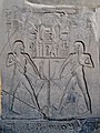
The union of Upper and Lower Egypt is depicted by knotted papyrus and reed plants. The binding motif represents both harmony through linkage and domination through containment. The duality is an important part of royal iconography. Sometimes, the duality is further extended by having the knotted plants extend and bind foreign foes (both from the North and the South) as well.[4]
During the first dynasty, dualistic royal titles emerge, including the King of Upper and Lower Egypt (nswt bjtj) title which combines the plant representing Upper Egypt and a bee representing Lower Egypt. The other dualistic title is the Two Ladies name or Nebty name. The two ladies are Nekhbet, the vulture goddess associated with Nekhen in Upper Egypt, and Wadjet, the cobra goddess associated with Buto in Lower Egypt.[4]
There are many depictions of the ritual unifications of the Two Lands. It is not known if this was perhaps a rite that would have been enacted at the beginning of a reign, or merely a symbolic representation. Many of the depictions of the unification show two gods binding the plants. Often the gods are Horus and Set, or on occasion Horus and Thoth. There are several examples of Barque stands from the reigns of Amenhotep III (Hermopolis), Taharqa (Jebel Barkal), and Atlanersa (Jebel Barkal) that show two river gods performing the rite. This matches a scene from the Temple at Abu Simbel from the time of Ramesses II.[5]
There are only a handful of scenes that show the King himself performing the ritual. All of these are from barque stands and date to the reigns of Amenhotep III, Seti I and Ramesses III. The latter two may be copies of the first one.[5]
-
-
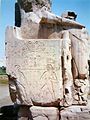
 Temple scene at Luxor, Thebes
 -
 Alabaster Jar depicting the sema tawy symbol with Hapy. From the tomb of Tutankhamun.
 -
 Ramesses III at the temple of Khonsu.
 -
 Sema tawy (without deities) on the side of the throne of Khafre


See also
[edit]References
[edit]- ^ Ronald J. Leprohon, The Great Name: Ancient Egyptian Royal Titulary, Society of Biblical Lit, 2013
- ^ Abeer El-Shahawy, Farid S. Atiya, The Egyptian Museum in Cairo, American Univ in Cairo Press, 2005
- ^ Grajetzki, Ancient Egyptian Queens: A Hieroglyphic Dictionary, Golden House Publications, London, 2005, ISBN 978-0954721893
- ^ a b c Wengrow, David, The Archaeology of Early Egypt: Social transformations in North-East Africa, 10,000 to 2650 B.C., Cambridge University Press, 2006
- ^ a b Rania Y. Merzeban, Unusual sm3 t3wy Scenes in Egyptian Temples, Journal of the American Research Center in Egypt, Vol. 44 (2008), pp. 41-71
