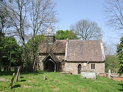
Upton Cressett
Appearance
| Upton Cressett | |
|---|---|
 St Michael's church | |
Location within Shropshire | |
| OS grid reference | SO655923 |
| Civil parish |
|
| Unitary authority | |
| Ceremonial county | |
| Region | |
| Country | England |
| Sovereign state | United Kingdom |
| Post town | BRIDGNORTH |
| Postcode district | WV16 |
| Dialling code | 01746 |
| Police | West Mercia |
| Fire | Shropshire |
| Ambulance | West Midlands |
| UK Parliament | |

Upton Cressett is a village and civil parish in the English county of Shropshire. Population details for the 2011 census are shown under Aston Eyre parish.
The village is notable as the location of three Grade I listed buildings, St Michael's church[1] Upton Cressett Hall[2] and the Gatehouse of the Hall.[3]
St Michael's church is now redundant and in the care of the Churches Conservation Trust. The Gatehouse of the hall has been renovated as a luxury country house hotel.
Near to the church and hall is the site of an abandoned medieval settlement.
See also
[edit]References
[edit]- ^ Historic England. "Former Church of St Michael (1367566)". National Heritage List for England. Retrieved 28 January 2014.
- ^ Historic England. "Upton Cressett Hall (1190045)". National Heritage List for England. Retrieved 28 January 2014.
- ^ Historic England. "Gatehouse at Upton Cressett Hall (1053757)". National Heritage List for England. Retrieved 28 January 2014.

