Višňov: Difference between revisions
Appearance
Content deleted Content added
m →External links: +it |
m #article-add-desc Tags: Mobile edit Mobile app edit iOS app edit |
||
| (9 intermediate revisions by 9 users not shown) | |||
| Line 1: | Line 1: | ||
{{Short description|Village and municipality in Slovakia}} |
|||
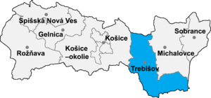
[[Image:Okres trebisov.png|thumb|right|300px|Location of Trebišov District in the [[Region]]]] |
[[Image:Okres trebisov.png|thumb|right|300px|Location of Trebišov District in the [[Region]]]] |
||
'''Višňov''' ({{lang-hu|Visnyó}}) is a [[village]] and [[municipality]] in the [[Trebišov District]] in the [[Košice Region]] of south-eastern [[Slovakia]]. |
'''Višňov''' ({{IPA-sk|ˈʋiʂɲɔw}}; {{lang-hu|Visnyó}}) is a [[village]] and [[municipality]] in the [[Trebišov District]] in the [[Košice Region]] of south-eastern [[Slovakia]]. |
||
==History== |
==History== |
||
In [[history|historical records]] the village was first mentioned in |
In [[history|historical records]] the village was first mentioned in 1270. |
||
==Geography== |
==Geography== |
||
| Line 16: | Line 17: | ||
==External links== |
==External links== |
||
*http://www.statistics.sk/mosmis/eng/run.html |
*https://web.archive.org/web/20071116010355/http://www.statistics.sk/mosmis/eng/run.html |
||
*[http://www.visnov.ocu.sk/ |
*[http://www.visnov.ocu.sk/ Official Internet page of Višňov (Slovak language)] |
||
{{Trebišov District}} |
{{Trebišov District}} |
||
{{coord|48|45|N|21|40|E|region:SK_type:city|display=title}} |
{{coord|48|45|N|21|40|E|region:SK_type:city|display=title}} |
||
{{authority control}} |
|||
{{DEFAULTSORT:Visnov}} |
{{DEFAULTSORT:Visnov}} |
||
| Line 28: | Line 32: | ||
{{Trebišov-geo-stub}} |
{{Trebišov-geo-stub}} |
||
[[eo:Višňov]] |
|||
[[fr:Višňov]] |
|||
[[hu:Visnyó]] |
|||
[[it:Višňov]] |
|||
[[nl:Višňov]] |
|||
[[sk:Višňov]] |
|||
[[war:Višňov]] |
|||
Revision as of 12:46, 5 March 2024

Višňov (Slovak pronunciation: [ˈʋiʂɲɔw]; Template:Lang-hu) is a village and municipality in the Trebišov District in the Košice Region of south-eastern Slovakia.
History
In historical records the village was first mentioned in 1270.
Geography
The village lies at an altitude of 122 metres and covers an area of 4.763 km². It has a population of about 220 people.
Ethnicity
The village is about 99% Slovak.
Facilities
The village has a public library.
External links
- https://web.archive.org/web/20071116010355/http://www.statistics.sk/mosmis/eng/run.html
- Official Internet page of Višňov (Slovak language)
48°45′N 21°40′E / 48.750°N 21.667°E
