Nukufetau: Difference between revisions
Appearance
Content deleted Content added
No edit summary |
Undid revision 204785071 by 74.56.36.75 (talk) |
||
| Line 24: | Line 24: | ||
* [[Teafuone]] |
* [[Teafuone]] |
||
* [[Temotuloto]] |
* [[Temotuloto]] |
||
* and at least |
* and at least 12 other islands |
||
The biggest island is [[Motulalo]]. [[Savave]] has a village. |
The biggest island is [[Motulalo]]. [[Savave]] has a village. |
||
Revision as of 22:11, 10 April 2008


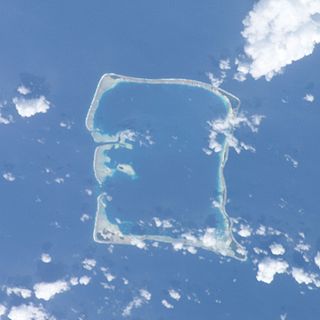
Nukufetau is one of the six atolls of the nation Tuvalu. The atoll was claimed by the US (not under the Guano Islands Act) some time in the 1800s and was ceded in a treaty of friendship concluded in 1979 and coming into force in 1983. It has a population (2002 census) of 586 and consists of at least 33 isles:
- Faiava Lasi
- Fale
- Funaota
- Kongo Loto Lafanga
- Lafanga
- Matanukulaelae
- Motufetau
- Motulalo
- Motuloa (north of Nukufetau)
- Motuloa (south of Nukufetau)
- Motumua
- Niualuka
- Niuatui
- Oua
- Sakalua
- Savave
- Teafatule
- Teafuaniua
- Teafuanonu
- Teafuone
- Temotuloto
- and at least 12 other islands
The biggest island is Motulalo. Savave has a village.
Passerby observation: I noticed a fact that seems fascinating ; the atoll forms a golden rectangle, that is a rectangle in the proportion of thegolden ratio .
Notable Local Person=
A notable local person is Saufatu Sopoanga, Prime Minister of Tuvalu 2002-2004, who has represented Nukufetau in the Parliament of Tuvalu for a number of years.

