Stanford End Mill and River Loddon
Appearance
| Site of Special Scientific Interest | |
 | |
| Location | Berkshire |
|---|---|
| Grid reference | SU 706 634[1] |
| Coordinates | 51°21′54″N 0°59′13″W / 51.365°N 0.987°W |
| Interest | Biological |
| Area | 11.8 hectares (29 acres)[1] |
| Notification | 1987[1] |
| Location map | Magic Map |
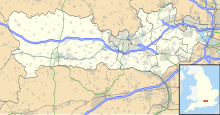
Stanford End Mill and River Loddon is a 11.8-hectare (29-acre) biological Site of Special Scientific Interest south of Reading in Berkshire.[1][2] It covers Stanford End Mill meadows and a 4 kilometres (2.5 miles) stretch of the River Loddon between Stanford End and Sheep Bridge north-west of Swallowfield.[3]
The mill was built in early Victorian times on the Stratfield Saye estate.[4]
Fauna
[edit]The site has the following animals[3]
Mammals
[edit]Birds
[edit]Invertebrates
[edit]Flora
[edit]The site has the following Flora:[3]
Trees
[edit]Plants
[edit]- Fritillaria meleagris
- Potamogeton nodosus
- Alopecurus pratensis
- Holcus lanatus
- Ranunculus acris
- Rumex acetosa
- Plantago lanceolata
- Centaurea nigra
- Rhinanthus minor
- Silaum silaus
- Ophioglossum vulgatum
- Carex disticha
- Carex panicea
- Cardamine pratensis
- Lychnis flos-cuculi
- Oenanthe fistulosa
- Potamogeton pectinatus
- Nuphar lutea
- Sagitarria sagittifolia
- Schoenoplectus lacustris
- Sparganium erectum
- Epilobium hirsutum
- Eupatorium cannabinum
- Symphytum officinale
- Lythrum salicaria
- Filipendula ulmaria
- Petasites hybridus
- Myosotis scorpioides
- Myosoton aquaticum
- Nasturtium officinale
- Urtica dioica
- Dipsacus fullonum
References
[edit]- ^ a b c d "Designated Sites View: Stanford End Mill and River Loddon". Sites of Special Scientific Interest. Natural England. Retrieved 24 October 2019.
- ^ "Map of Stanford End Mill and River Loddon". Sites of Special Scientific Interest. Natural England. Retrieved 24 October 2019.
- ^ a b c "Stanford End Mill and River Loddon citation" (PDF). Sites of Special Scientific Interest. Natural England. Retrieved 24 October 2019.
- ^ Water Mills on the Thames and Loddon, Wargrave Local History Society, May 2015

