Kotel Gap: Difference between revisions
Appearance
Content deleted Content added
external links |
m brackets fixed |
||
| Line 12: | Line 12: | ||
==References== |
==References== |
||
* [https://data.aad.gov.au/aadc/gaz/scar/display_name.cfm?gaz_id=134063 Kotel Gap.] SCAR [Composite Antarctic Gazetteer]] |
* [https://data.aad.gov.au/aadc/gaz/scar/display_name.cfm?gaz_id=134063 Kotel Gap.] SCAR [[Composite Antarctic Gazetteer]] |
||
* [http://apcbg.org/gazet-bg.pdf Bulgarian Antarctic Gazetteer.] [[Antarctic Place-names Commission]]. (details in Bulgarian, [http://apcbg.org/gazet.pdf basic data] in English) |
* [http://apcbg.org/gazet-bg.pdf Bulgarian Antarctic Gazetteer.] [[Antarctic Place-names Commission]]. (details in Bulgarian, [http://apcbg.org/gazet.pdf basic data] in English) |
||
==External links== |
==External links== |
||
* [https://copernix.io/#?where=-60.08293395239259,-62.68897377266294,15&?query=&?map_type=hybrid Kotel Gap.] Copernix satellite image |
* [https://copernix.io/#?where=-60.08293395239259,-62.68897377266294,15&?query=&?map_type=hybrid Kotel Gap.] Copernix satellite image |
||
{{Bulgarian-named Antarctic place}} |
{{Bulgarian-named Antarctic place}} |
||
Latest revision as of 06:44, 22 June 2024


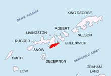
Kotel Gap (Kotelska Sedlovina \'ko-tel-ska se-dlo-vi-'na\) is a saddle of elevation 660 m extending 1 km between Serdica Peak and Silistra Knoll in Levski Ridge, Tangra Mountains on Livingston Island in the South Shetland Islands, Antarctica. The saddle is part of the divide between the glacial catchments of Macy Glacier to the north and Boyana Glacier to the south. It was named after the Bulgarian town of Kotel.
Location
[edit]The midpoint is located at 62°41′23″S 60°04′53″W / 62.68972°S 60.08139°W.
Maps
[edit]- L.L. Ivanov et al. Antarctica: Livingston Island and Greenwich Island, South Shetland Islands. Scale 1:100000 topographic map. Sofia: Antarctic Place-names Commission of Bulgaria, 2005.
- L.L. Ivanov. Antarctica: Livingston Island and Greenwich, Robert, Snow and Smith Islands. Scale 1:120000 topographic map. Troyan: Manfred Wörner Foundation, 2009.
References
[edit]- Kotel Gap. SCAR Composite Antarctic Gazetteer
- Bulgarian Antarctic Gazetteer. Antarctic Place-names Commission. (details in Bulgarian, basic data in English)
External links
[edit]- Kotel Gap. Copernix satellite image
This article includes information from the Antarctic Place-names Commission of Bulgaria which is used with permission.
