Trefin: Difference between revisions
No edit summary Tags: Reverted Mobile edit Mobile web edit |
|||
| Line 22: | Line 22: | ||
}} |
}} |
||
'''Trefin''' is a village in the [[Welsh language|Welsh-speaking]] area of North [[Pembrokeshire]], south-west [[Wales |
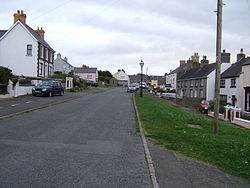
'''Trefin''' is a village in the [[Welsh language|Welsh-speaking]] area of North [[Pembrokeshire]], south-west [[Wales]]. Trefin's name comes from the [[Welsh language|Welsh]] ''Trefaen'' meaning 'village on the rock outcrop'. The rock outcrop can be seen in many places around Trefin, especially its centre. The village lies within the parish and [[Community (Wales)|community]] of [[Llanrhian]]. |
||
==History== |
==History== |
||
Revision as of 19:27, 12 July 2022
| Trefin | |
|---|---|
 | |
Location within Pembrokeshire | |
| Population | 216 |
| OS grid reference | SM8230 |
| Community |
|
| Principal area | |
| Country | Wales |
| Sovereign state | United Kingdom |
| Post town | Haverfordwest |
| Postcode district | SA62 |
| Dialling code | 01348 |
| Police | Dyfed-Powys |
| Fire | Mid and West Wales |
| Ambulance | Welsh |
| UK Parliament | |
| Senedd Cymru – Welsh Parliament | |
Trefin is a village in the Welsh-speaking area of North Pembrokeshire, south-west Wales. Trefin's name comes from the Welsh Trefaen meaning 'village on the rock outcrop'. The rock outcrop can be seen in many places around Trefin, especially its centre. The village lies within the parish and community of Llanrhian.
History

Although small, Trefin is an historical village. It is linked to the Archdruid Crwys, who was born in Craig Cefn Parc, Glamorganshire, and the historic mill at Aberfelin is the subject of his poem Melin Trefin.[1] The mill was in use for around 500 years and was used by the villagers of Trefin and surrounding areas. Wheat was milled to produce flour for bread and barley was ground into winter feed for livestock. By the 1900s cheap grain was being imported from overseas and milled in larger mills in towns and cities and Trefin Mill closed in 1918. The mill stones remain in the ruins of the roofless mill.[2]
Community
Trefin is an area of outstanding beauty, surrounded by the Irish Sea and on the Pembrokeshire Coast Path, between Porthgain and Abercastle. It is on the route of the Strumble Shuttle bus service, part of the Pembrokeshire Greenways public transport service. Trefin lies within the Pembrokeshire Coast National Park, the only coastal area included in the National parks of the United Kingdom.
Trefin is a small village of around 130 people, and houses a weaving centre, The Mill cafe, two chapels (both now closed), a pub The Ship Inn, a hostel 'Old School Hostel' as well as holiday accommodation. Nearby villages include Llanrhian, Abercastle, Porthgain, Mathry, Square and Compass, Penparc and Croesgoch.
Notable people
- Edgar Phillips born 8 October 1889: Welsh poet and served as Archdruid of the National Eisteddfod of Wales
- Cerys Matthews: singer, songwriter, author, and broadcaster
References
- ^ "Cerys names baby after home". 19 August 2003. Retrieved 6 July 2016 – via bbc.co.uk.
- ^ "Geograph:: Ruins of Trefin Mill/Melin Trefin (C) Pauline E". Retrieved 6 July 2016.

