
Hindutash Pass: Difference between revisions
→History: wikilink xaidulla |
rv factually incorrect information added by Fowler and Fowler (indulging in Foul Play). added a new reference item and appropriate quotation from the said reference. |
||
| Line 1: | Line 1: | ||
{{ |
{{coor title dms|36|16|23|N|78|46|50|E|}} |
||
[[Image:78.96268E 36.26053N nasa kanxiwar.jpg|right|thumb|250px|NASA satellite image showing the towns of |
[[Image:78.96268E 36.26053N nasa kanxiwar.jpg|right|thumb|250px|NASA satellite image showing the towns of Sumgal in Ladakh and Pusa in southwestern [[Khotan]], and the Hindu-tash Pass connecting them. The pass is marked in bright red.]] |
||
[[Image:Hindutagh-pass-aksai-chin-center2-1873.jpg|thumb|right|250px|Details of a map of [[ |
[[Image:Hindutagh-pass-aksai-chin-center2-1873.jpg|thumb|right|250px|Details of a map of [[Kashmir ]] (1878) showing the [[Hindutash]] Pass and [[Khotan]] as well as the northern border regions of the [[British Raj|British Indian Empire]] (which included the [[Kashmir region]]).<ref name=trotter1878-U8/> The international border is shown in the two-toned purple and pink band. The mountain passes are shown in bright red. Warning the lat/long information is not everywhere correct.]] |
||
'''Hindutash''', also known as '''Hindu-tagh Pass''', is the name of a historical [[mountain pass]] in north eastern [[Kashmir]]. The pass cuts through the [[Kunlun Mountains]] connecting the now-deserted town of [[Sumgal]], (36° 11' 58'' N, 78° 46' 50'' E) in the [[Karakash River]] valley to the town of Pusha, (36.3833° N, 79° E), formerly Bushia, in the [[Yurungkash River]] valley, in the territory of [[Khotan]] and also connects to the road to the city of [[ Khotan]]. <ref name=trotter1878-U8> {{Harv|Trotter|1878|p=U8}} </ref> (See maps on right.) In 1857, the explorer [[Robert Schlagintweit]] crossed this pass from camping grounds in Sumgal ( meaning "three fords" in Ladakhi ), on the banks of the Karakash river, approximately 7 miles upstream from Sumgal in Ladakh and estimated its height to be {{ft to m|17879|abbr=yes|precision=0}}. At the top of the pass (36° 16' 23'' N, 78° 46' 50'' E), there is a steep glacier with many crevasses. “The eastern (Kuenlun) range forms the southern boundary of [[Khotan]]”, and is crossed by cut by two other passes: the ''Sanju Pass'' near the town of Shahidulla, where the Maharaja of Kashmir had built a fort in exercise of his sovereignty in that area of Kashmir northwest of Hindutash, and the ''Ilchi Pass'', southeast of Hindutash in the northern part of the [[Aksai Chin]] area in [[Ladakh]] (see second map on right). The Hindutash pass has been used historically as the point of entry into India Proper from the ancient Indian [[Kingdom of Khotan]] which only explains the literal meaning of the name Hindutash signifying border post . The latter was traversed in 1865 by W. H. Johnson of the [[Survey of India]]. W.H. Johnson’s survey established certain important points. "Brinjga was in his view the boundary post" ( near the Karanghu Tagh Peak in the Kuen Lun in Ladakh ), thus implying "that the boundary lay along the Kuen Lun Range". Johnson’s findings demonstrated that the whole of the [[Kara Kash]] valley was “ within the territory of the Maharaja of Kashmir” and an integral part of the territory of Kashmir . "He noted where the Chinese boundary post was accepted. At Yangi Langar, three marches from Khotan, he noticed that there were a few fruit trees at this place which originally was a post or guard house of the Chinese". “The Khan wrote Johnson ‘that he had dispatched his Wazier, Saifulla Khoja to meet me at Bringja, the first encampment beyond the Ladakh boundary for the purpose of escorting me thence to Ilichi’… thus the Khotan ruler accepted the Kunlun range as the southern boundary of his dominion.” According to Johnson, “the last portion of the route to Shadulla (Shahidulla) is particularly pleasant, being the whole of the Karakash valley which is wide and even, and shut in either side by rugged mountains. On this route I noticed numerous extensive plateaux near the river, covered with wood and long grass. These being within the territory of the Maharaja of Kashmir, could easily be brought under cultivation by Ladakhees and others, if they could be induced and encouraged to do so by the Kashmeer Government. The establishment of villages and habitations on this river would be important in many points of view, but chiefly in keeping the route open from the attacks of the Khergiz robbers.” "Hindu-tagh" means "Indian Mountain," and "Hindu-tash," "Indian stone" in the [[Uyghur language|Uyghur dialect]] of East Turkistan. |
|||
'''Hindutash''', also known as '''Hindu-tagh Pass''', is the name of a historical [[mountain pass]] in the western [[Xinjiang Uyghur Autonomous Region]] (formerly, [[Chinese Turkestan]]) of the [[People's Republic of China]]. The pass cuts through the [[Kunlun Mountains]] connecting the now-deserted town of ''Kangxiwar'', formerly Kengshewar, (36° 11' 58'' N, 78° 46' 50'' E) in the [[Karakash River]] valley to the town of Pusha, (36.3833° N, 79° E), formerly Bushia, in the [[Yurungkash River]] valley, and also connects to the road to the city of [[Hotan]], formerly Khotan. <ref name=trotter1878-U8> {{Harv|Trotter|1878|p=U8}} </ref> (See maps on right.) |
|||
==History== |
|||
In 1857, the explorer [[Robert Schlagintweit]] crossed this pass from camping grounds in Sumgal ("three fords"), on the banks of the Karakash river, approximately 7 miles upstream from Kengshewar and estimated its height to be {{ft to m|17879|abbr=yes|precision=0}}. At the top of the pass (36° 16' 23'' N, 78° 46' 50'' E), there is a steep glacier with many crevasses. The eastern Kunlun range, which is in the southern region of the [[Hotan]] [[Prefecture#Chinese_equivalents_of_prefecture|prefecture]] of Xinjiang, is cut by two other passes: the ''Sanju Pass'' near the town of [[Xaidulla]], formerly Shahidulla, northwest of Hindu-tagh, and the ''Ilchi Pass'', southeast of Hindu-tagh, just north-east of the village of [[Dahongliutan]], itself just north of the now disputed [[Aksai Chin]] area (see second map on right). The former pass had been much used historically, and provided the traditional means of entry from the south into the ancient [[Kingdom of Khotan]]. The latter was traversed in 1865 by W. H. Johnson of the [[Survey of India]]. "Hindu-tagh" means "Indian Mountain," and "Hindu-tash," "Indian stone" in the [[Uyghur language|Uyghur dialect]] of Xinjiang. |
|||
==Gallery== |
==Gallery== |
||
<Gallery> |
<Gallery> |
||
Image:Chain-of-kuenluen-from-sumgal1857a.jpg|"The Chain of the Kuenlúen, from Súmgal, in |
Image:Chain-of-kuenluen-from-sumgal1857a.jpg|"The Chain of the Kuenlúen, from Súmgal, in Ladakh (Lat North 36° 8', Long. East of Green. 78° 5', Height 13, 215 Engl. feet)" by [[Hermann Schlagintweit]], August 1856. Lithographed by Sabatier, printed in oil-colours by Lemereier, Paris. The Hindu-tagh Pass is the break in the mountains on the right. |
||
Image:IMG_0542.jpg|Karakash River in the Western Kunlun Range, seen from the [[ |
Image:IMG_0542.jpg|Karakash River in the Western Kunlun Range, seen from the [[Pan- Kashmir Highway]] |
||
<!--Image:Peak in Kunlun range.jpg|Peak in Kunlun range--> |
<!--Image:Peak in Kunlun range.jpg|Peak in Kunlun range--> |
||
Image:Kunlun_IMG_0541.jpg|View of Western Kunlun Range from the [[ |
Image:Kunlun_IMG_0541.jpg|View of Western Kunlun Range from the [[Pan- Kashmir Highway]] |
||
</Gallery> |
</Gallery> |
||
==Maps== |
==Maps== |
||
<Gallery> |
<Gallery> |
||
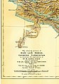
Image:NWFP-Kashmir1909-a.jpg|A lower-resolution 1909 Map of the [[Kashmir region|Princely State of Kashmir and Jammu]]. Sumgal at the base of the |
Image:NWFP-Kashmir1909-a.jpg|A lower-resolution 1909 Map of the [[Kashmir region|Princely State of Kashmir and Jammu]]. Sumgal at the base of the Hindutash Pass, [[Ladakh]], [[Kashmir]] is shown in the top right corner. |
||
Image: |
Image:Yangi-hindutash-aurel-stein-map-1911.jpg|Map of [[Aurel Stein]] (1911) based on that of the Survey of India showing the "Hindutash Dawan" in the Kunlun Mountains in [[Ladakh]] |
||
Image:Yangi-hindutash-aurel-stein-map-1911.jpg|Map of [[Aurel Stein]] (1911) based on that of the Survey of India showing the "Hindutash Dawan" in the Kunlun Mountains in [[Chinese Turkestan]] |
|||
</Gallery> |
</Gallery> |
||
<Gallery> |
<Gallery> |
||
Image:Johnson-journey-ilchi1865-mapa.jpg|Map of W. H. Johnson showing the route of his trip to Khotan from Leh; in this map, Johnson refers to the pass as "Hindotak diwan Pass." |
Image:Johnson-journey-ilchi1865-mapa.jpg|Map of W. H. Johnson showing the route of his trip to Khotan from Leh; in this map, Johnson refers to the pass as "Hindotak diwan Pass." He himself traveled through the Yangi diwan Pass, some 20 miles up-river from Hindutash, on his outward journey, and returned via the Sanju diwan Pass near Shahdula. Johnson placed the border of Kashmir with Turkistan at Bringja. (Refer accompanying maps for position of Bringja) The Map unequivocally and with out an iota of doubt depicts Hindutash pass as part of Kashmir. |
||
He himself traveled through the Yangi diwan Pass, some 20 miles up-river from Hindutash, on his outward journey, and returned via the Sanju diwan Pass near Shahdula (modern Xaidulla). |
|||
</Gallery> |
</Gallery> |
||
==Notes== |
==Notes== |
||
| Line 90: | Line 86: | ||
| url=http://links.jstor.org/sici?sici=0266-6235%281878%2948%3C173%3AOTGROT%3E2.0.CO%3B2-N |
| url=http://links.jstor.org/sici?sici=0266-6235%281878%2948%3C173%3AOTGROT%3E2.0.CO%3B2-N |
||
}}. |
}}. |
||
* Gazetteer of Kashmir and Ladak compiled under the direction of the Quarter Master | General in India in the Intelligence Branch. First Published in 1890 by the Superintendent of Government Printing, Calcutta. Compiled under the Direction of the Quartermaster -General in India in the Intelligence | Branch. 1890 Ed. Pg. 520, 364 |
|||
* Report of the Great Trigonometrical Survey of India, 1866, p.6. |
|||
* Map referred to in Art.9 of the Simla Convention between Great Britain, China and Tibet, 1914 signed by the Chinese representative. |
|||
* Atlas of the northern frontiers of India . Pg.20 |
|||
* Himalayan Frontiers by Dorothy Woodman. Pg.67-68 |
|||
* Himalayan Battleground by Margaret W. Fisher, Leo E. Rose and Robert A. Huttenback. Pg.116. |
|||
==See also== |
==See also== |
||
*[[ |
*[[Kashmir]] |
||
*[[Aksai Chin]] |
*[[Aksai Chin]] |
||
*[[Kunlun Mountains]] |
*[[Kunlun Mountains]] |
||
*[[Yurungkash]] |
*[[Yurungkash]] |
||
*[[Karakash River]] |
*[[Karakash River]] |
||
*[[Indian Sub-continent]] |
|||
== External links == |
== External links == |
||
*[http://www.friendsofjade.org/display/ShowJournal?moduleId=395351¤tPage=5&categoryId=27465 Friends of Jade: Jade in Khotan]. |
*[http://www.friendsofjade.org/display/ShowJournal?moduleId=395351¤tPage=5&categoryId=27465 Friends of Jade: Jade in Khotan]. |
||
*[http://www.guardian.co.uk/world/2001/jul/25/china.comment China as victim of history? I don't think so]. |
|||
*[http://siris-libraries.si.edu/ipac20/ipac.jsp?uri=full=3100001~!46428!0#focus Gazetteer of Kashmir]. |
|||
| ⚫ | |||
*[http://hindutashravi.blogspot.com/2008/06/survey-of-india.html Territory of Kashmir]. |
|||
| ⚫ | |||
| ⚫ | |||
| ⚫ | |||
[[Category:South Asia]] |
|||
[[Category:Turkestan]] |
[[Category:Turkestan]] |
||
[[Category:Silk Road]] |
[[Category:Silk Road]] |
||
Revision as of 13:26, 4 February 2009
36°16′23″N 78°46′50″E / 36.27306°N 78.78056°E


Hindutash, also known as Hindu-tagh Pass, is the name of a historical mountain pass in north eastern Kashmir. The pass cuts through the Kunlun Mountains connecting the now-deserted town of Sumgal, (36° 11' 58 N, 78° 46' 50 E) in the Karakash River valley to the town of Pusha, (36.3833° N, 79° E), formerly Bushia, in the Yurungkash River valley, in the territory of Khotan and also connects to the road to the city of Khotan. [1] (See maps on right.) In 1857, the explorer Robert Schlagintweit crossed this pass from camping grounds in Sumgal ( meaning "three fords" in Ladakhi ), on the banks of the Karakash river, approximately 7 miles upstream from Sumgal in Ladakh and estimated its height to be Template:Ft to m. At the top of the pass (36° 16' 23 N, 78° 46' 50 E), there is a steep glacier with many crevasses. “The eastern (Kuenlun) range forms the southern boundary of Khotan”, and is crossed by cut by two other passes: the Sanju Pass near the town of Shahidulla, where the Maharaja of Kashmir had built a fort in exercise of his sovereignty in that area of Kashmir northwest of Hindutash, and the Ilchi Pass, southeast of Hindutash in the northern part of the Aksai Chin area in Ladakh (see second map on right). The Hindutash pass has been used historically as the point of entry into India Proper from the ancient Indian Kingdom of Khotan which only explains the literal meaning of the name Hindutash signifying border post . The latter was traversed in 1865 by W. H. Johnson of the Survey of India. W.H. Johnson’s survey established certain important points. "Brinjga was in his view the boundary post" ( near the Karanghu Tagh Peak in the Kuen Lun in Ladakh ), thus implying "that the boundary lay along the Kuen Lun Range". Johnson’s findings demonstrated that the whole of the Kara Kash valley was “ within the territory of the Maharaja of Kashmir” and an integral part of the territory of Kashmir . "He noted where the Chinese boundary post was accepted. At Yangi Langar, three marches from Khotan, he noticed that there were a few fruit trees at this place which originally was a post or guard house of the Chinese". “The Khan wrote Johnson ‘that he had dispatched his Wazier, Saifulla Khoja to meet me at Bringja, the first encampment beyond the Ladakh boundary for the purpose of escorting me thence to Ilichi’… thus the Khotan ruler accepted the Kunlun range as the southern boundary of his dominion.” According to Johnson, “the last portion of the route to Shadulla (Shahidulla) is particularly pleasant, being the whole of the Karakash valley which is wide and even, and shut in either side by rugged mountains. On this route I noticed numerous extensive plateaux near the river, covered with wood and long grass. These being within the territory of the Maharaja of Kashmir, could easily be brought under cultivation by Ladakhees and others, if they could be induced and encouraged to do so by the Kashmeer Government. The establishment of villages and habitations on this river would be important in many points of view, but chiefly in keeping the route open from the attacks of the Khergiz robbers.” "Hindu-tagh" means "Indian Mountain," and "Hindu-tash," "Indian stone" in the Uyghur dialect of East Turkistan.
Gallery
-
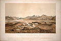 "The Chain of the Kuenlúen, from Súmgal, in Ladakh (Lat North 36° 8', Long. East of Green. 78° 5', Height 13, 215 Engl. feet)" by Hermann Schlagintweit, August 1856. Lithographed by Sabatier, printed in oil-colours by Lemereier, Paris. The Hindu-tagh Pass is the break in the mountains on the right.
 -
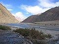 Karakash River in the Western Kunlun Range, seen from the Pan- Kashmir Highway
 -
 View of Western Kunlun Range from the Pan- Kashmir Highway


Maps
-
 A lower-resolution 1909 Map of the Princely State of Kashmir and Jammu. Sumgal at the base of the Hindutash Pass, Ladakh, Kashmir is shown in the top right corner.
 -
 Map of Aurel Stein (1911) based on that of the Survey of India showing the "Hindutash Dawan" in the Kunlun Mountains in Ladakh


-
 Map of W. H. Johnson showing the route of his trip to Khotan from Leh; in this map, Johnson refers to the pass as "Hindotak diwan Pass." He himself traveled through the Yangi diwan Pass, some 20 miles up-river from Hindutash, on his outward journey, and returned via the Sanju diwan Pass near Shahdula. Johnson placed the border of Kashmir with Turkistan at Bringja. (Refer accompanying maps for position of Bringja) The Map unequivocally and with out an iota of doubt depicts Hindutash pass as part of Kashmir.

Notes
- ^ a b (Trotter 1878, p. U8)
References
- Template:Harvard reference.
- Template:Harvard reference.
- Template:Harvard reference.
- Template:Harvard reference.
- Template:Harvard reference.
- Gazetteer of Kashmir and Ladak compiled under the direction of the Quarter Master | General in India in the Intelligence Branch. First Published in 1890 by the Superintendent of Government Printing, Calcutta. Compiled under the Direction of the Quartermaster -General in India in the Intelligence | Branch. 1890 Ed. Pg. 520, 364
- Report of the Great Trigonometrical Survey of India, 1866, p.6.
- Map referred to in Art.9 of the Simla Convention between Great Britain, China and Tibet, 1914 signed by the Chinese representative.
- Atlas of the northern frontiers of India . Pg.20
- Himalayan Frontiers by Dorothy Woodman. Pg.67-68
- Himalayan Battleground by Margaret W. Fisher, Leo E. Rose and Robert A. Huttenback. Pg.116.
See also