
Liscannor: Difference between revisions
Liscannorman (talk | contribs) No edit summary |
Liscannorman (talk | contribs) No edit summary |
||
| Line 77: | Line 77: | ||
<gallery> |
<gallery> |
||
Image:Page11.jpg|Mausoleum of Cornelius O Brien, St Brigids Well, Liscannor |
|||
Image:Page10.jpg|O'Briens Monument, St Brigids Well, Liscannor |
Image:Page10.jpg|O'Briens Monument, St Brigids Well, Liscannor |
||
Image:Page7.jpg|Round Table at Cliffs of Moher erected by Cornelius O Brien (no longer present) |
Image:Page7.jpg|Round Table at Cliffs of Moher erected by Cornelius O Brien (no longer present) |
||
Revision as of 09:19, 8 April 2009
Template:Infobox Place Ireland
Introduction
Liscannor (Irish: Lios Ceannúir) is a coastal village in County Clare, Ireland. Lying on the west coast of Ireland, on Liscannor Bay, the village is located on the R478 road between Lahinch, to the east, and Doolin, to the north. The Cliffs of Moher are about 5 km (3 miles) west of the village. Between Lahinch and Liscannor lies the small village of Moymore.
History
The area around Liscannor belonged in former times to the Chieftains of Corcomroe – the O’Connors. Corcomroe was one of five ancient divisions into which the County of Clare was divided. The four others were:
1. Corcovaskin whose chiefs were of the O’Donnells and McMahons
2. Ui-Cormaic was inhabited by the tribes of the O’Hehirs
3. Ui-Fearmaic was the territory corresponding to the barony of Inchiquin and inhabited by the ODeas and the O’Quinns
4. Ui-Caisin or Clancuilen was occupied by the powerful clan of the MacNamaras including the baronies of upper and lower Bunratty.
Some say Liscannor takes its name from the old castle beside the local National School; “Lis” meaning a “fort” and “Cannor” a corruption of the name “Connor”. Others say that it is derived from “Lis”, a “fort”, “cean” a “head or headland” and “or” (uir) meaning “slaughter”.
The village of Liscannor was said not to exist before the year 1775. In a statistical survey of the district made about 1810 we are informed that at this latter date there were nearly 200 houses in it and about ten of them had flag roofs. It is of interest that though Liscannor was not in existence until relatively recently it was in existence before Ennistymon was built up. Almost all the county about Ennistymon save for a few gentlemen’s residences and their demesnes was up to the early 19th century covered with woods mainly of oak and ash.
Liscannor Harbour
The harbour currently has a number of fishing vessels moored there as well as smaller boats using it is a launching site for sea fishing/recreational sports. During Summer months there is also a ferry service to the bas eof the Cliffs of Moher as well as to the Aran Islands.
In the past the harbour was a busy hub of activity with numerous fishing vessels as well as a location to export locally quarried Liscannor Stone and to receive in supplies e.g. coal. However historical documents note that due to the silting of the harbour, ships could only carry approximately 380 tonnes into port. At low tides ships had to be winched into harbour. A currach would bring the rope out to the ship. There was often rivalry between boats to be the first to the ship.
The harbour life boat was a large heavy wooden rowing boat, manned by members of the Coastguard Station (behind the Lower Quay). John P Holland’s father was “Head Boatman”. It was raised and lowered by winch in the boat house.
Locally quarried flag was cut and polished beside the harbour and winched onto ships by steam crane. These slabs were transported to various British cities (Glasgow, Manchester, etc) for use as pavement slabs. The haulage company who transported these flags was called ‘Watsons’.
Coal was delivered directly to Liscannor up until the mid 1960’s for Griffins coal yard in Ennistymon. However in the mid 1960s a boat ran aground just outside the harbour and sank. The insurance became too expensive and coal was then delivered to Clarecastle and subsequently delivered to Ennistymon for distribution. The harbour was built in 1825-31 for £2,900, of which £2,000 was a government grant.
-
 Liscannor Harbour I
 -
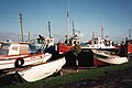 Liscannor Harbour II
 -
 Liscannor Harbour III
 -
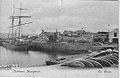 Old photo of Liscannor Harbour


Cornelius O'Brien
Cornelius O’Brien was the third son of Henry and Helen O’Brien, of Ennis, County Clare. He was born in Birchfield, (originally Beaghy but angliscised to Birchfield) Liscannor in 1782. The estate is first mentioned in an inquisition of 1625 as the property of Thomas O’Cahill whose family name is preserved in the neighbouring townland of Caherycahill.
He married in 1816, to Margaret, daughter of Peter Long of Waterford. Cornelius was
1. a solicitor in Ireland from 1811,
2. a magistrate for Clare,
3. a Liberal in favour of the Repeal of the Union with Ireland,
4. Sat for Clare from 1832 to 1847 when he was an unsuccessful candidate. Regained seat July 1852.
He retired 1857 and died the same year. Various local memoirs tell of Cornelius O’Brien’s conversation to Catholicism but nowhere is their confirmation of this. After lying in state before the front door of Birchfield House, his coffin was taken to St. Brigid’s Cemetery followed by thousands of mourners in a mile-long funeral procession. Here the burial rites were read by his great friend, Most. Rev. Dr. Fallon, Bishop of Kilfenora. Then the remains were laid to rest in a temporary tomb pending the completion of the family vault.
Local recollections of Cornelius O’Brien hold no hint of kindness or generosity. However records of the time are more favourable. The Lewis Topographical Dictionary, 1837, refers to Birchfield – “The residence of Cornelius O’Brien who has much improved his estate and the condition of his tenantry by the erection of neat slated cottages and farm buildings and by other judicious arrangements; - a holy well dedicated to St. Brigid and much resorted to by the peasantry, which, at Mr. O’Brien’s expense, has been surrounded by tasteful plantations and rustic seats.” Nowhere is it mentioned of the rack-renting and evictions so common in other parts of Clare. O’Brien’s work for the poor is praised by Rev. J. Sheehan, P.P., Ennistymon and the Clare Journal paid this tribute to him in his obituary: -
“As a landlord, no man was held in greater love and esteem by his tenantry. They clung to him in many a well-fought field of contention and carried him triumphant through every contest.”
As well as Birchfield Estate remnants of Cornelius’ time in Liscannor can be found at St. Brigid’s Well, O Brien’s Monument and O Brien’s Tower at the Cliffs of Moher. All of the above information is thanks to the research of Henry Comber.
-
O'Briens Monument, St Brigids Well, Liscannor
-
Round Table at Cliffs of Moher erected by Cornelius O Brien (no longer present)
-
O'Briens Tower, Cliffs of Moher, Liscannor
-
 Present Day Cornelius O Brien Mausoleum

St. Brigid’s Well
Dabhach Bhríde is found near the Cliffs of Moher in an area of great scenic beauty and behind the well on a higher level to which steps lead, is an ancient cemetery in which the Uí Bhrian, the Kings of Dál gCais, are buried. There is a large cross here and a circular path around it and part of the Rite of the Holy Well is performed in this area known as the ‘Ula Uachtarach’ or upper sanctuary.
The Well itself is in the lower ground, the ‘Ula íochtarach’ or lower sanctuary, enclosed in a little house full of votive offerings such as holy pictures, rosaries, medals and so forth left by pilgrims. Small items which people carry around with them, such as pens, biros and combs, are commonly found also as offerings at wells.
This site has a particularly mysterious atmosphere which may be felt at once by the pilgrims as they enter the grove and hears the gentle lapping of the water in the background. Something of the ancient ‘Nemeton’ (modern Irish neimheadh)- the outdoor Celtic Sanctuary - is, perhaps, to be experienced here.
Many pilgrims from all over County Clare and from the Aran Islands came to Liscannor. There were four different Pattern Days on which large groups attended:
1. St Brigid’s Eve
2. Garland Saturday
3. Garland Sunday
4. The Feast of the Assumption of the Blessed Virgin Mary into Heaven, on August 15.
John P Holland
John Philip Holland, inventor of the modern submarine, was born in Liscannor at Castle Street (now renamed Holland Street) in Liscannor in 1841. Holland was fascinated by the sea and in particular with models of underwater vessels. In 1873, he moved to America where he continued to teach and design his submarine. His motivation was that one day his vessels might sink British warships! The Irish Republican Brotherhood financed Holland's one-man model and continued with the necessary finance until the launching in 1881 of the Fenian Ram. This submarine was 31 foot long with a 19 tons displacement and could carry a three man crew. The Fenian Ram 'the intended scourge of the British Navy', never saw warfare but survives intact in the museum in Patterson, New Jersey. After many near hits, the Liscannor man finally perfected his design with the launching of the Holland in 1898; this was to provide the prototype for the first mass-produced submarines. John Holland, the father of the modern submarine, died in August 1914, a few days before the outbreak of WWI in which his perfected underwater weapons played a major role. Today, a headstone, commemorating his career, presented (1977) to the town by the U.S. Navy, can be viewed outside the local community centre.
Geographical coordinates
- Latitude: 52° 56' 31" N (52.942)
- Longitude: 9° 23' 9.6" W (-9.386)
See also
List of towns and villages in Ireland
External links
- Liscannor History - at Clare Library
- Liscannor page - at Tour Clare
- Tourist information - at Clare-Tour
- Comment on the harbour in 1901

52°56′N 9°23′W / 52.933°N 9.383°W
This article related to the geography of County Clare, Ireland is a stub. You can help Wikipedia by expanding it. |