
Appin, New South Wales: Difference between revisions
No edit summary |
|||
| Line 38: | Line 38: | ||
'''Appin''' is a town in the [[Macarthur, New South Wales|Macarthur Region]] of [[New South Wales]], [[Australia]] in [[Wollondilly Shire]]. It is situated about 16 kilometres south of [[Campbelltown, New South Wales|Campbelltown]] and 35 kilometres north west of [[Wollongong, New South Wales|Wollongong]]. |
'''Appin''' is a town in the [[Macarthur, New South Wales|Macarthur Region]] of [[New South Wales]], [[Australia]] in [[Wollondilly Shire]]. It is situated about 16 kilometres south of [[Campbelltown, New South Wales|Campbelltown]] and 35 kilometres north west of [[Wollongong, New South Wales|Wollongong]]. |
||
| ⚫ | |||
==Population== |
|||
===Early History=== |
|||
| ⚫ | |||
Appin is in the lands of the [[Tharawal people|Dharawal]] people. |
|||
<blockquote>"During the Dreaming a great fire swept through the land. Wiritjiribin led the people to sanctuary in a cool green gully |
|||
| ⚫ | |||
which had been missed by the fire, under the rocky cliffs of a gorge south of Appin. Those |
|||
who had perished in the fire were reincarnated as animals and Wiritjiribin appeared as a |
|||
lyrebird, which became the clan’s totem, a symbol of peace and caretaker of the Land of |
|||
Gawaigl, an area which became a meeting place for Peoples from all over the east coast of |
|||
Australia"<ref>[www.phansw.org.au/ROPHO/broughton.pdf Gawaian Bodkin-Andrews, "The D’haraua |
|||
the People of This Land," cited in Register of Historic Places and Objects]</ref></blockquote> |
|||
European settlement in the Appin district was prohibited for some years; Appin was part of the 'Cowpastures' where a small herd of cattle had established themselves, having escaped from the Sydney Cove settlement. To protect these and help feed the colony, [[Lachlan Macquarie|Governor Macquarie]] ordered 'No person to hunt or travel into the Cowpastures without licence under penalty of death' <ref>[http://www.dictionaryofsydney.org/entry/economy Cattle escape from Sydney Cove]</ref><ref>[http://www.lib.mq.edu.au/digital/lema/1810/index.html Proclamations by Governer Macquarie]</ref>. |
|||
The town was named by [[Governor Macquarie]] in 1811 after the [[Appin| small coastal village]] in Scotland where his wife was born. <ref>[http://www.smh.com.au/news/New-South-Wales/Appin/2005/02/17/1108500192574.html Appin - ''Sydney Morning Herald'' February 8, 2004]</ref> |
|||
Naturalist George Caley had visited the area in 1807 exploring 'from Prospect to the upper waters of George's River and the Cataract and Cordeaux Rivers' and reporting his findings. <ref>http://adbonline.anu.edu.au/biogs/A010180b.htm ADB Online George Caley]</ref> Settlement began in 1811 with a 1000 [[Acre|acre]] land grant by Governor Macquarie to William Broughton, who had arrived with the First Fleet. For the next five years, smaller grants of 40 to 150 acres were made to a score or so of others, former soldiers, emancipated convicts. Governor Macquarie was pleased to give 'The District of Appin' its name, after [[Appin]], in the Scottish West Highlands where his wife, Elizabeth, was born. <ref>Whitaker, ''Appin: the story of a Macquarie Town''</ref> |
|||
===The Appin Massacre=== |
|||
Dharawal people made friendships among several Appin settlers, but others came into conflict. In 1814, both Aborigines and Europeans died in skirmishes, usually over stolen crops. After further deaths at [[Bringelly, New South Wales|Bringelly]]<ref group="n.">The killings of Europeans were possibly by [[Gandangara people|Gandganara]] intruders hunting during a time of drought. See Whitaker, p. 11]</ref>Macquarie sent a punitive expedition to round up all Aborigines in the area. Those who resisted were to be shot. On April 16, at least 14 were killed by shooting; others were driven to jump to their deaths into a rocky gorge, believed to be the Broughton Pass.<ref>[www.phansw.org.au/ROPHO/broughton.pdf Appin Massacre]</ref> |
|||
| ⚫ | |||
Among Appin's free settlers was one Andrew Hamilton Hume, father of the explorer [[Hamilton Hume]]. Hamilton Hume and his brother John were tireless investigators of the local countryside, often journeying in the company of Dharawal man Duall. Hamilton Hume became an expert bushman, and was well-prepared for major exploration when he set out in 1824 from 'Humewood',<ref>[www.campbelltown.nsw.gov.au/upload/.../MeadowvaleHumewood.pdf Humewood, home of the Humes. Retrieved 24 June 2010]</ref> in the company of William Hovell to explore the land between the Sydney settlements and Port Phillip, at the request of [[Thomas Brisbane|Governor Brisbane]].<ref>[[Hume and Hovell expedition]]</ref> A stone monument to this event stands on Campbelltown Road, erected by the Royal Australian Historical Society in 1924. Stone was obtained from the ruins of Hamilton Hume’s house.</ref> |
|||
| ⚫ | |||
[[Rachel Henning]] spent several months at Elladale Cottage in Appin. |
|||
Of the area, she wrote: |
|||
"I am glad [Biddulph] is going to leave Appin, however, for I am sure he will |
|||
never make any money on this farm. Do you remember our saying that there |
|||
must certainly be something the matter with it, when he wrote word of how |
|||
low the rent was, that there must be a want of water or that nothing |
|||
would grow? There are both these drawbacks here. |
|||
The soil is wretchedly poor, and this is said to be the very driest part |
|||
of Australia. Frequently, when there have been torrents of rain at |
|||
Wollongong and Sydney, on each side of us, we have not had a drop here. |
|||
There are no springs on the farm, only a waterhole, and that was dry for |
|||
nearly six weeks in the summer, and then we had to fetch water from the |
|||
river three miles off. It is a pity Biddulph ever took this farm; still, |
|||
he has gained some experience here, and, as his expenditure was chiefly |
|||
in cattle and furniture, he has not lost much."<ref> ''The Letters of Rachel Henning'' March 29, 1855.</ref> |
|||
===Agricullture and Industry=== |
|||
Appin was for decades a major wheat-growing, and dairy-farming area, but [[Wheat leaf rust|wheat rust]], and new railways reaching other primary producing areas of the State, reduced its importance. From 1869, however, the district became the major supplier of Sydney's water, when construction commenced on the [[Upper_Nepean_Scheme|Upper Nepean Scheme]]: four major dams and an associated 40 miles of canals and tunnels supplying [[Prospect reservoir|Prospect Reservoir.]]<ref>Whitaker, Chapter Nine</ref> The Appin Colliery, exploiting the Bulli Seam by [[Longwall mining|longwall mining]] opened in 1962. The West Cliff Colliery opened in 1976. |
|||
===Infrastructure=== |
|||
A town plan was completed in 1834. Several of the proposed street names are in use today, including Toggerai, the Dharawal name for the Upper reaches of the Georges River. A track from Campbelltown was in use from 1815; as settlement advanced along coastal Illawarra, routes to Sydney found their way up the [[Illawarra escarpment|escarpment]], and through Appin, increasing the town's prosperity. <ref>Whitaker, Chapter V</ref> |
|||
Appin had a permanent Post Office by 1841, and a telephone line was connected to it in 1888. Appin had to wait until 1945 for an electricity supply. Despite its proximity to several large dams, Appin did not receive a reticulated water supply until 1961. <ref>Whitaker, Chapter 13</ref> As of 2010, a town sewerage scheme is in its planning stages.<ref>[http://www.sydneywater.com.au/majorprojects/SouthWest/AppinWiltonandDouglasParkSewerageScheme.cfm Appin Wilton and Douglas Park Sewerage Scheme]</ref> |
|||
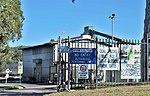
| ⚫ | Several examples of early sandstone buildings remain in Appin's commercial centre on Appin Road. These include the former Courthouse and Gaol (1860s), the derelict Appin Inn (1826), a stone cottage used as offices, built ''circa'' 1840, the Headmaster's residence at the primary school, and St. Bede's Roman Catholic Church, 1834-7. Other buildings of heritage value include the disused motor garage at Darcy’s Corner (1955), the Appin Hotel (1840), and St Mark The Evangelist Church (1843) |
||
| ⚫ | |||
| ⚫ | Several examples of early sandstone buildings |
||
==The Town Today== |
==The Town Today== |
||
| ⚫ | |||
===Community Facilities=== |
===Community Facilities=== |
||
The Wollondilly Mobile Library visits the township weekly<ref>[http://www.library.wollondilly.nsw.gov.au/Mobile-Library Mobile Library]</ref> Appin offers residents a Playgroup; a Mobile PreSchool; a Community Hall, a sportsground, and an off-leash area for companion animals near Wonson Oval. The Appin Volunteer Bush Fire Brigade (now known as the Appin Rural Fire Service) was formed in 1944; Joe D'Arcy was its first Captain. The current Fire Shed was opened in 2002. |
|||
| ⚫ | |||
=== |
===In the Surrounding Area=== |
||
The [[16th World Scout Jamboree]] was held at the Cataract Scout Camp<ref>[http://www.nsw.scouts.com.au/scouts/ScoutsSectionContent.aspx?id=460 Cataract Scout Camp]</ref>, the first such Jamboree held in the [[Southern Hemisphere]]. The Dharawal State Recreation Area and Nature Reserve<ref>[http://www.environment.nsw.gov.au/NationalParks/parkHome.aspx?id=N0627 Dharawal State Conservation Area]</ref> is located to the east. Appin is part of the Upper Georges River Catchment. <ref>[http://wollondilly.local-e.nsw.gov.au/environment/1276/8757.html#nepean Catchment Notes]</ref>The Bureau of Meterology operates a Weather Watch radar station at [[Bulli, New South Wales|Bulli]], known as the "Sydney (Appin) radar" {{location|34|15|36|S|150|52|12|E}}. Its coverage extends to Newcastle, Bathurst, Lake George and Ulladulla."<ref group="n.">[http://www.bom.gov.au/weather/radar/info/NSW.info.shtml#my_03 Appin Radar] </ref> |
|||
===Sport=== |
|||
| ⚫ | |||
| ⚫ | |||
The coal mines continue to be a major employer. Inghams Enterprises operate several factory farms. An industrial area has been established to the south of Appin. Here also is the Macarthur Water Treatment Plant. Completed in 1995, it supplies the Camden, Campbelltown and Wollondilly areas.<ref>[www.unitedutilities.com.au/site/DefaultSite/filesystem/.../Macarthur.pdf Macarthur Water Treatment Plant]</ref> |
|||
===Education=== |
|||
| ⚫ | |||
[http://www.appin-p.schools.nsw.edu.au/ Appin Public School] was opened in 1867. Before this, Catholic and Anglican Denominational Schools had been conducted in the district, but both had closed by 1870. |
|||
Secondary school students today attend High Schools in [[Campbelltown, New South Wales|Campbelltown]] and other areas . Tertiary education is available from institutions in adjacent towns: [[University_of_western_sydney#Campbelltown_campus|the University of Western Sydney]] at Campbelltown, The [[University of Wollongong]] and [http://www.swsi.tafensw.edu.au/aboutswsi/colleges/campbelltown.aspx Campbelltown College of TAFE]. |
|||
==Footnotes== |
|||
| ⚫ | |||
| ⚫ | |||
North of town lie the [http://www.aussiesportsinfo.com/greyhounds/new_south_wales/appin_way_greyhound_racing_track.php Appin Greyhound Track] and the Appin Motocross Circuit [http://macarthur-chronicle-wollondilly.whereilive.com.au/sport/story/appin-motocross-meet-roars-to-life/ Motocross]. Tennis courts and a sportsground are located within the township (Wonson Oval). Appin is home to the Appin Dogs Rugby League Football Teams: a women's rugby team was established in 2010 [http://macarthur-chronicle-camden.whereilive.com.au/sport/story/appin-dogs-seek-players-coaches-and-sponsorship/ Appin Dogs]. Appin United Soccer Club have their home ground at the Gordon Lewis Oval. |
|||
==Notes and References== |
|||
==Further Reading== |
|||
;Notes |
|||
* Whitaker, Anne-Maree. 2005. ''Appin: the story of a Macquarie town.'' Kingsclear Books, Sydney. |
|||
<references group="n."/> |
|||
;References |
|||
| ⚫ | |||
==External Links== |
==External Links== |
||
Revision as of 06:13, 24 June 2010
| Appin New South Wales | |||||||||||||||
|---|---|---|---|---|---|---|---|---|---|---|---|---|---|---|---|
 Northern entry to Appin | |||||||||||||||
 Appin | |||||||||||||||
| Coordinates | 34°12′3″S 150°47′14″E / 34.20083°S 150.78722°E | ||||||||||||||
| Population | 1,423 (2006 census)[1] | ||||||||||||||
| Postcode(s) | 2560 | ||||||||||||||
| Elevation | 150 m (492 ft) | ||||||||||||||
| Location |
| ||||||||||||||
| LGA(s) | Wollondilly Shire | ||||||||||||||
| Region | Macarthur | ||||||||||||||
| State electorate(s) | Wollondilly | ||||||||||||||
| Federal division(s) | Macarthur | ||||||||||||||
| |||||||||||||||
Appin is a town in the Macarthur Region of New South Wales, Australia in Wollondilly Shire. It is situated about 16 kilometres south of Campbelltown and 35 kilometres north west of Wollongong.
History of the District
Early History
Appin is in the lands of the Dharawal people.
"During the Dreaming a great fire swept through the land. Wiritjiribin led the people to sanctuary in a cool green gully
which had been missed by the fire, under the rocky cliffs of a gorge south of Appin. Those who had perished in the fire were reincarnated as animals and Wiritjiribin appeared as a lyrebird, which became the clan’s totem, a symbol of peace and caretaker of the Land of Gawaigl, an area which became a meeting place for Peoples from all over the east coast of
Australia"[2]
European settlement in the Appin district was prohibited for some years; Appin was part of the 'Cowpastures' where a small herd of cattle had established themselves, having escaped from the Sydney Cove settlement. To protect these and help feed the colony, Governor Macquarie ordered 'No person to hunt or travel into the Cowpastures without licence under penalty of death' [3][4].
Naturalist George Caley had visited the area in 1807 exploring 'from Prospect to the upper waters of George's River and the Cataract and Cordeaux Rivers' and reporting his findings. [5] Settlement began in 1811 with a 1000 acre land grant by Governor Macquarie to William Broughton, who had arrived with the First Fleet. For the next five years, smaller grants of 40 to 150 acres were made to a score or so of others, former soldiers, emancipated convicts. Governor Macquarie was pleased to give 'The District of Appin' its name, after Appin, in the Scottish West Highlands where his wife, Elizabeth, was born. [6]
The Appin Massacre
Dharawal people made friendships among several Appin settlers, but others came into conflict. In 1814, both Aborigines and Europeans died in skirmishes, usually over stolen crops. After further deaths at Bringelly[n. 1]Macquarie sent a punitive expedition to round up all Aborigines in the area. Those who resisted were to be shot. On April 16, at least 14 were killed by shooting; others were driven to jump to their deaths into a rocky gorge, believed to be the Broughton Pass.[7]
Notable Citizens
Among Appin's free settlers was one Andrew Hamilton Hume, father of the explorer Hamilton Hume. Hamilton Hume and his brother John were tireless investigators of the local countryside, often journeying in the company of Dharawal man Duall. Hamilton Hume became an expert bushman, and was well-prepared for major exploration when he set out in 1824 from 'Humewood',[8] in the company of William Hovell to explore the land between the Sydney settlements and Port Phillip, at the request of Governor Brisbane.[9] A stone monument to this event stands on Campbelltown Road, erected by the Royal Australian Historical Society in 1924. Stone was obtained from the ruins of Hamilton Hume’s house.</ref>
Appin is the birthplace of John Fuller, better known as the bushranger Dan 'Mad Dog' Morgan.
Rachel Henning spent several months at Elladale Cottage in Appin.
Of the area, she wrote:
"I am glad [Biddulph] is going to leave Appin, however, for I am sure he will never make any money on this farm. Do you remember our saying that there must certainly be something the matter with it, when he wrote word of how low the rent was, that there must be a want of water or that nothing would grow? There are both these drawbacks here.
The soil is wretchedly poor, and this is said to be the very driest part
of Australia. Frequently, when there have been torrents of rain at
Wollongong and Sydney, on each side of us, we have not had a drop here.
There are no springs on the farm, only a waterhole, and that was dry for
nearly six weeks in the summer, and then we had to fetch water from the
river three miles off. It is a pity Biddulph ever took this farm; still,
he has gained some experience here, and, as his expenditure was chiefly
in cattle and furniture, he has not lost much."[10]
Agricullture and Industry
Appin was for decades a major wheat-growing, and dairy-farming area, but wheat rust, and new railways reaching other primary producing areas of the State, reduced its importance. From 1869, however, the district became the major supplier of Sydney's water, when construction commenced on the Upper Nepean Scheme: four major dams and an associated 40 miles of canals and tunnels supplying Prospect Reservoir.[11] The Appin Colliery, exploiting the Bulli Seam by longwall mining opened in 1962. The West Cliff Colliery opened in 1976.
Infrastructure
A town plan was completed in 1834. Several of the proposed street names are in use today, including Toggerai, the Dharawal name for the Upper reaches of the Georges River. A track from Campbelltown was in use from 1815; as settlement advanced along coastal Illawarra, routes to Sydney found their way up the escarpment, and through Appin, increasing the town's prosperity. [12]
Appin had a permanent Post Office by 1841, and a telephone line was connected to it in 1888. Appin had to wait until 1945 for an electricity supply. Despite its proximity to several large dams, Appin did not receive a reticulated water supply until 1961. [13] As of 2010, a town sewerage scheme is in its planning stages.[14]
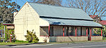
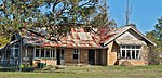
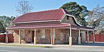
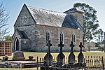
Several examples of early sandstone buildings remain in Appin's commercial centre on Appin Road. These include the former Courthouse and Gaol (1860s), the derelict Appin Inn (1826), a stone cottage used as offices, built circa 1840, the Headmaster's residence at the primary school, and St. Bede's Roman Catholic Church, 1834-7. Other buildings of heritage value include the disused motor garage at Darcy’s Corner (1955), the Appin Hotel (1840), and St Mark The Evangelist Church (1843)
The Town Today
On Census night 2006, Appin had a population of 1,423 people.
Community Facilities
The Wollondilly Mobile Library visits the township weekly[15] Appin offers residents a Playgroup; a Mobile PreSchool; a Community Hall, a sportsground, and an off-leash area for companion animals near Wonson Oval. The Appin Volunteer Bush Fire Brigade (now known as the Appin Rural Fire Service) was formed in 1944; Joe D'Arcy was its first Captain. The current Fire Shed was opened in 2002.
In the Surrounding Area
The 16th World Scout Jamboree was held at the Cataract Scout Camp[16], the first such Jamboree held in the Southern Hemisphere. The Dharawal State Recreation Area and Nature Reserve[17] is located to the east. Appin is part of the Upper Georges River Catchment. [18]The Bureau of Meterology operates a Weather Watch radar station at Bulli, known as the "Sydney (Appin) radar" 34°15′36″S 150°52′12″E / 34.26000°S 150.87000°E. Its coverage extends to Newcastle, Bathurst, Lake George and Ulladulla."[n. 2]
Industries, Employment
The coal mines continue to be a major employer. Inghams Enterprises operate several factory farms. An industrial area has been established to the south of Appin. Here also is the Macarthur Water Treatment Plant. Completed in 1995, it supplies the Camden, Campbelltown and Wollondilly areas.[19]
Education
Appin Public School was opened in 1867. Before this, Catholic and Anglican Denominational Schools had been conducted in the district, but both had closed by 1870.
Secondary school students today attend High Schools in Campbelltown and other areas . Tertiary education is available from institutions in adjacent towns: the University of Western Sydney at Campbelltown, The University of Wollongong and Campbelltown College of TAFE.
Sport
North of town lie the Appin Greyhound Track and the Appin Motocross Circuit Motocross. Tennis courts and a sportsground are located within the township (Wonson Oval). Appin is home to the Appin Dogs Rugby League Football Teams: a women's rugby team was established in 2010 Appin Dogs. Appin United Soccer Club have their home ground at the Gordon Lewis Oval.
Notes and References
- Notes
- ^ The killings of Europeans were possibly by Gandganara intruders hunting during a time of drought. See Whitaker, p. 11]
- ^ Appin Radar
- References
- ^ Australian Bureau of Statistics (25 October 2007). "Appin (Urban Centre/Locality)". 2006 Census QuickStats. Retrieved 8 June 2009.
- ^ [www.phansw.org.au/ROPHO/broughton.pdf Gawaian Bodkin-Andrews, "The D’haraua the People of This Land," cited in Register of Historic Places and Objects]
- ^ Cattle escape from Sydney Cove
- ^ Proclamations by Governer Macquarie
- ^ http://adbonline.anu.edu.au/biogs/A010180b.htm ADB Online George Caley]
- ^ Whitaker, Appin: the story of a Macquarie Town
- ^ [www.phansw.org.au/ROPHO/broughton.pdf Appin Massacre]
- ^ [www.campbelltown.nsw.gov.au/upload/.../MeadowvaleHumewood.pdf Humewood, home of the Humes. Retrieved 24 June 2010]
- ^ Hume and Hovell expedition
- ^ The Letters of Rachel Henning March 29, 1855.
- ^ Whitaker, Chapter Nine
- ^ Whitaker, Chapter V
- ^ Whitaker, Chapter 13
- ^ Appin Wilton and Douglas Park Sewerage Scheme
- ^ Mobile Library
- ^ Cataract Scout Camp
- ^ Dharawal State Conservation Area
- ^ Catchment Notes
- ^ [www.unitedutilities.com.au/site/DefaultSite/filesystem/.../Macarthur.pdf Macarthur Water Treatment Plant]
External Links
- Appin The Story of a Macquarie Town
- Appin Canal collapse 2007
- Appin sewerage proposal
- Upper Nepean Dams
- Appin Power Plant 1996
- Power Plant controversy
- Appin Aeromodellers Club
- Methane Gas Power Generation
- Methane Gas Power Generation
- Leaf's Gully Power Plant
- Sykes Family history
- St. Bede's Church graveyard listing
- Appin history
- St. Bede's history
- Heritage Listing, Upper Canal System (Pheasants Nest Weir to Prospect Reservoir)
Appin Gallery
-
Former Post Office, 1835 -

Appin Public School, 1867 -
Derelict Appin Inn, 1826 -
Colonial era stone building
in main street -

Former Anglican Rectory, 1843 -
St Bede's Catholic Church, 1837-43 -

St Mark the Evangelist
Anglican Church, 1843 -
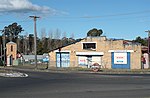
Darcy's Corner, c. 1955. -

Broughton's Pass Weir -
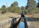
Upper Canal
west of Appin -
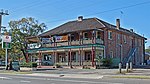
Appin Hotel -
Entrance, Appin Colliery -

Methane Gas Power Plant -

Inghams Broilers factory farm -

Industrial Area, south of town -

Rural Fire Brigade Shed


This New South Wales geography article is a stub. You can help Wikipedia by expanding it. |