Hauraki Plains: Difference between revisions
map added |
GrahamBould (talk | contribs) mNo edit summary |
||
| Line 3: | Line 3: | ||
The '''Hauraki Plains''' are an area located in the northern [[North Island]] of [[New Zealand]]. They are located 75 kilometres southeast of [[Auckland]], at the foot of the [[Coromandel Peninsula]] and are bounded on the east by the [[Kaimai Ranges]] and the west by a series of undulating hills which separate them from the much larger plains of the [[Waikato River]]. Administratively, they are largely within the [[Hauraki (district), New Zealand|Hauraki]] district. |
The '''Hauraki Plains''' are an area located in the northern [[North Island]] of [[New Zealand]]. They are located 75 kilometres southeast of [[Auckland]], at the foot of the [[Coromandel Peninsula]] and are bounded on the east by the [[Kaimai Ranges]] and the west by a series of undulating hills which separate them from the much larger plains of the [[Waikato River]]. Administratively, they are largely within the [[Hauraki (district), New Zealand|Hauraki]] district. |
||
The [[alluvial]] plains have been built up by sediment |
The [[alluvial]] plains have been built up by sediment deposited by the [[Piako River|Piako]] and [[Waihou/Thames River]]s, which flow south to reach the sea at the [[Firth of Thames]]. The resulting land is flat, peat-heavy, and partly swampy, but it is also excellent land for [[dairy]] farming, which is the main local industry. |
||
The largest town in the plains is [[Ngatea]], although the larger [[Te Aroha]] is located near their southern boundary with the [[Thames Valley, New Zealand|Thames Valley]]. |
The largest town in the plains is [[Ngatea]], although the larger [[Te Aroha]] is located near their southern boundary with the [[Thames Valley, New Zealand|Thames Valley]]. |
||
Revision as of 13:15, 27 April 2006


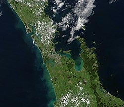
The Hauraki Plains are an area located in the northern North Island of New Zealand. They are located 75 kilometres southeast of Auckland, at the foot of the Coromandel Peninsula and are bounded on the east by the Kaimai Ranges and the west by a series of undulating hills which separate them from the much larger plains of the Waikato River. Administratively, they are largely within the Hauraki district.
The alluvial plains have been built up by sediment deposited by the Piako and Waihou/Thames Rivers, which flow south to reach the sea at the Firth of Thames. The resulting land is flat, peat-heavy, and partly swampy, but it is also excellent land for dairy farming, which is the main local industry.
The largest town in the plains is Ngatea, although the larger Te Aroha is located near their southern boundary with the Thames Valley.
