
Talk:Control of cities during the Syrian civil war: Difference between revisions
| Line 978: | Line 978: | ||
According to SOHR Halafaya is "almost" under SAA control https://www.facebook.com/syriahroe/posts/581827448592264. Several twitters state that is in full control. |
According to SOHR Halafaya is "almost" under SAA control https://www.facebook.com/syriahroe/posts/581827448592264. Several twitters state that is in full control. |
||
Of course, we will wait till the news is confirmed.[[User:Paolowalter|Paolowalter]] ([[User talk:Paolowalter|talk]]) 17:47, 11 September 2014 (UTC) |
Of course, we will wait till the news is confirmed.[[User:Paolowalter|Paolowalter]] ([[User talk:Paolowalter|talk]]) 17:47, 11 September 2014 (UTC) |
||
:Why do you put the word almost in quotation marks when it does not appear anywhere in the source? [[User:Boredwhytekid|Boredwhytekid]] ([[User talk:Boredwhytekid|talk]]) 17:51, 11 September 2014 (UTC) |
|||
Revision as of 17:52, 11 September 2014
| This is the talk page for discussing improvements to the Control of cities during the Syrian civil war article. This is not a forum for general discussion of the article's subject. |
Article policies
|
| Find sources: Google (books · news · scholar · free images · WP refs) · FENS · JSTOR · TWL |
| Archives: Index, 1, 2, 3, 4, 5, 6, 7, 8, 9, 10, 11, 12, 13, 14, 15, 16, 17, 18, 19, 20, 21, 22, 23, 24, 25, 26, 27, 28, 29, 30, 31, 32, 33, 34, 35, 36, 37, 38, 39, 40, 41, 42, 43, 44, 45, 46, 47, 48, 49, 50, 51, 52, 53, 54, 55, 56, 57, 58, 59, 60, 61, 62, 63, 64, 65Auto-archiving period: 14 days |
| This page is not a forum for general discussion about Control of cities during the Syrian civil war. Any such comments may be removed or refactored. Please limit discussion to improvement of this article. You may wish to ask factual questions about Control of cities during the Syrian civil war at the Reference desk. |
| This article is of interest to the following WikiProjects: | |||||||||||||||||||||||||||||||||||||||||||||
| |||||||||||||||||||||||||||||||||||||||||||||


.svg)
| To help centralise discussions and keep related topics together, Template talk:Syrian Civil War detailed map redirects here. |
Template:Syrian Civil War sanctions
|
Index 1, 2, 3, 4, 5, 6, 7, 8, 9, 10 |
|
This page has archives. Sections older than 14 days may be automatically archived by Lowercase sigmabot III when more than 4 sections are present. |
Roads
Shouldn't this map show at least the major roads and railways? After all, maneuver is critical in warfare, and that would explain more why this or that city or village is strategic. — Preceding unsigned comment added by 24.8.182.120 (talk)
- Absolutely. Someone please create a version of the base Syria location map with those features drawn. Alternatively, we need a picture file that has syria roads on it and nothing else. I can then use the "overlay_image =" parameter in the "Template:Location map+" to overlay that "road file" on top of our map. For an example of the result of this parameter, see a "Location map+" where a picture file with arrows was overlayed on top of it. Unfortunately, i don't know how to create picture files. If anyone can create such a file (same size as our map; with a transparent background) and put it in commons, then i can overlay it on top of our map. Tradediatalk I brought this back from archives as this is still an ongoing issue. And while we are at this, it would be good to also draw Lake Jabbūl Tradediatalk
- I agree that adding some of the most important highways to the map would make it more useful. It would have to be done delicately, because it could quickly make the map very cluttered. Looking at road maps of Syria, I would suggest something showing a few major highways, along the lines of this [1] (scroll down slightly), rather than something more like this [2], which would overwhelm the map. Hulahoop122 (talk)
- Good idea. Between those 2 examples, the difference seems more how the roads are drawn (thin red lines vs. wide light brown lines), than the number of roads. In some areas, there seems to be more roads on the first map with the roads in red.
- Note that our map is bigger, so we could probably place more roads (if appropriate) without problem. In some areas there are many alternative roads allowing easy passage around the main routes, so it might be a good idea to indicate that.
- With a good source map with the roads already on it (and not too many complicated things in the same colour), I could produce the road overlay. The colour of the roads could be changed to whatever you like.
- There is a map on my computer that might be good, with many roads, except it could be as much as 20 years old. (The latest date on the map is a 1994 border treaty.) It is better to have something not long before the civil war started.
- According to my map, most of lake Jabbul is dry much of the year. (All except the north-west corner.) It also has rivers and railways, which might be interesting to show. (the roads, water, and railways could be put on separate layers so as to be easier to maintain, if necessary. Not hard since they are all different colours.) André437 (talk)
- If you have the skills to put that map layer together, that would be great. You could post it on a test page, just as you did with all of the conflict icons you created, and see how the community reacts. Hulahoop122 (talk)
- Ok, as I have time. It could take a while, since I will have to use google maps or equivalent to fill in the few places where a small window overlay covers roads, etc in some areas, and also clean up any stray marks I find. (There are a lot of annotations, but mostly outside Syria.)
- I'll also have to adjust the scale and align it, which will be the most difficult part.
- I'll put the roads/water/railways in separate layers initially as well. Easy to do since they are separate colours. That way it will be really quick to modify (or remove) one without affecting the others.
- That icon project helped remind me of a few tricks with the software I use. (gimp)
- BTW, I have an unrelated idea for locations contested from one side only : using a semicircle open on the opposite side. And for truces, using a broken outside circle, instead of a continuous one. Just mentioning it as something to think about.
- I'll keep you posted :) André437 (talk)
- If you have the skills to put that map layer together, that would be great. You could post it on a test page, just as you did with all of the conflict icons you created, and see how the community reacts. Hulahoop122 (talk)
- This section disappeared for a while and I became occupied elsewhere, but my map turned out to be so overwritten with place names so as to be almost useless. Most roads, rivers, etc were obscured in many places. It would be faster to draw features freehand using google maps in satellite mode. Not one of my talents. So I can't help much with that.
- I've noticed that some waterways have been added. It looks really nice. André437 (talk)
Deir Ez Zor contryside
SOHR reported that the rebels took control of many villages after clashes against ISIS https://www.facebook.com/syriahroe/posts/536128479828828 waiting for more sources FS1991
Khalfatli
According to SOHR, this border town is currently controlled by ISIS. https://www.facebook.com/photo.php?fbid=10152562069038115
IS in Damascus Pocket
According to AP -citing SOHR- the IS controls parts of Damascus pocket. They are now in "Al-Hajar Al-Aswad, Tadamon and Qadam in southern Damascus" https://uk.news.yahoo.com/syria-rebels-press-offensive-against-jihadists-near-damascus-110556227.html To have an accurate map of greater Damascus, should the Damascus map be altered for part of the green pocket to be black? It is fascinating to see this map develop and how much input people have put into it.
map changes
The map may soon need to add a new color. See news here on major split occurring within rebel ranks: http://www.stuff.co.nz/world/middle-east/10301860/Syrian-insurgents-seize-3-towns
Eastern Gouta
IS controls Mesraba in Eastern Gouta but I cannot see it on Damascus map — Preceding http://www.globaltimes.cn/content/870192.shtml
Red Towns deleted from Hasakah province why ?
We used before a pro insurgent source https://www.facebook.com/syriahroe/posts/562706100504399 for draw these towns the discussion is here https://en.wikipedia.org/wiki/Talk:Cities_and_towns_during_the_Syrian_Civil_War/Archive_21#SAA_advancing_in_Hasakah
Why it was deleted
Incorrect location or a new vandalism case ?--Pototo1 (talk) 11:02, 24 August 2014 (UTC)
- See Talk:Cities and towns during the Syrian Civil War/Archive 22#Names of some villages and towns Tradediatalk 01:38, 5 September 2014 (UTC)
Tabqa Airbase is IS held
SANA also confirmed it. SOHR confirmed it. International media confirmed it. All free-lancer reporters on twitter reported it. The base is IS held(unfortunetly) It was already black and you changed it to red for some reason, not put it back to black.
http://www.almasdarnews.com/article/islamic-state-captures-tabqa-airbase-last-government-stronghold-ar-raqqa/ Stop vandalising it, it's IS not regime held. Also, this pro-regime website claims this ends all SAA presence in Raqqa, so all red towns need to be changed to black.
Daara central prison
For some reason, it was excluded from the map. http://www.dailystar.com.lb/News/Middle-East/2014/Mar-19/250704-syria-army-fighting-for-control-of-krak-fort-official.ashx#axzz2uAA4pFGD It was taken in March.
http://wikimapia.org/#lang=pt&lat=32.597879&lon=36.166477&z=15&m=b
Here is it's location. Put it there as a rebel held facility(just like Aleppo Central Prison).
Towns controlled by SAA in Hasakah province
Are these https://www.facebook.com/syriahroe/posts/562706100504399
These towns were deleted or ISIS controlled it now ?
Jaza'a and surrounding villages
Jaza'a and surrounding villages are put on black, but KUrdish sources claim to hold the town. http://en.firatnews.com/news/news/ypg-4-gang-members-killed-in-jazaa.htm Should be put on contested. M.Burri (talk) 14:39, 26 August 2014 (UTC)
Jaza'a is held by Islamic State, they posted the photo set of their conquest and the failed results of a Kurdish attempt to retake it. https://justpaste.it/ja7im_pkk All these dead soldiers showed up in YPG films said to have been taken while recapturing Jaza'a, as you can see they died and failed.Tgoll774 (talk) 10:53, 1 September 2014 (UTC)
Stop vandalising Tabqa around
The airbase is NOT under regime siege. Is under full IS control, yes, some clashes maybe around according to SOHR, put SOHR reports clashes around many places, such as Deir Ez-Zor Airport, put you don't put it under siege, so why to put Tabqa? It's not under any siege, regime lost all of Raqqa for now. — Preceding unsigned comment added by 179.179.152.147 (talk) 02:59, 27 August 2014 (UTC)
I will be removed the red circle if nobody post sources here in next hours --Pototo1 (talk) 05:48, 27 August 2014 (UTC)
- SOHR said that clashes around al-Tabaqa military airport.source Hanibal911 (talk) 06:48, 27 August 2014 (UTC)
--Removed: flamebaiting
- Can't say I disagree.. Boredwhytekid (talk) 12:18, 27 August 2014 (UTC)
- So essentially, ban everyone who does not agree with what you say the first time you say it. Yes, that will get us closer to an unbiased map. — Preceding unsigned comment added by 2602:30A:C01B:89F0:4C1F:A767:8E14:8CED (talk) 20:12, 27 August 2014 (UTC)
http://www.telegraph.co.uk/news/wor...Syrian-soldiers-in-latest-brutal-killing.html
Fleeing soldiers from Tabqa airbase are marched in the desert and executed en masse...
Map shows the regime besieging Tabqa...
Fleeing soldiers...mass execution...besieging Tabqa...
Something is wrong with this picture... — Preceding unsigned comment added by 80.184.67.215 (talk) 20:46, 28 August 2014 (UTC)
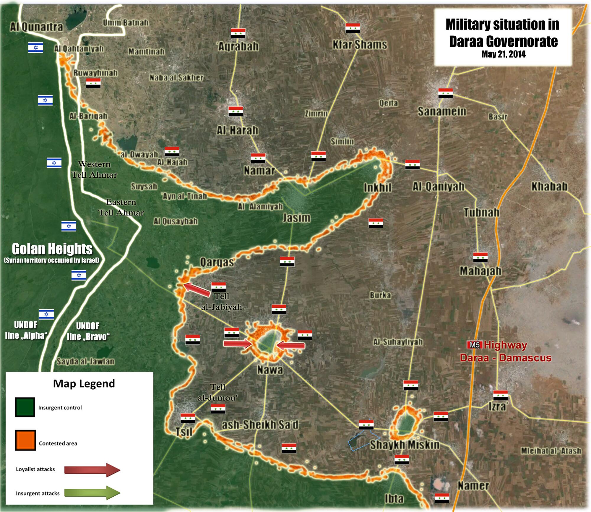
Quneitra
Rebels captured Quneitra crossing [3]. [4] --איש המרק (talk) 12:30, 27 August 2014 (UTC)
REUTERS reports that the urban center/ town of Quneitra is under state control. However the border crossing of Quneitra that is almost 20 kilometers west of Quneitra has been captured by AN and its allied western-supplied "moderate" rebels. http://in.reuters.com/article/2014/08/28/syria-crisis-border-fighting-idINKBN0GS04H20140828 — Preceding unsigned comment added by 169.231.3.204 (talk) 03:43, 28 August 2014 (UTC)
Quneitra crossing fell to the rebels:
http://news.yahoo.com/rebels-syria-crossing-israel-occupied-golan-ngo-110506731.html http://www.dailystar.com.lb/News/Lebanon-News/2014/Aug-27/268671-syrian-rebels-seize-control-of-qunaitra-crossing-into-golan-heights-activists.ashx#axzz3BaxIp9ci Boredwhytekid (talk) 12:31, 27 August 2014 (UTC)
- The rebels captured the crossing, but the town of Quneitra itself, 20 kilometers east, is still held by the SAA [5]. A red dot for the town needs to be added. EkoGraf (talk) 07:33, 28 August 2014 (UTC)
 Done Hanibal911 (talk) 08:17, 28 August 2014 (UTC)
Bteich checkpoint
Bteich checkpoint should red. According to sohr :The Islamic battalions and al Nusra Front targeted regime’s gatherings in Btesh checkpoint by the heavy gun machines https://www.facebook.com/syriahroe/posts/575525282555814212.252.198.124 (talk) 17:31, 28 August 2014 (UTC)
why Flitah change to red to contested ?
sources or it go to red again in next hours --Pototo1 (talk) 19:05, 28 August 2014 (UTC)
via https://www.facebook.com/syriahroe/posts/575180572590285, Falita is contested and stop reverting edits with reliable sources.Alhanuty (talk) 02:50, 29 August 2014 (UTC)
- But SOHR partly biased in the rebels side and no one from another reliable sources not said that clashes in this city. And it can be was only hit and run atack because even SOHR more not said about clashes inside city of Flita. Also on 23 August SOHR reported that clashes in the city Talbisa but we not change him to contested because SOHR more not said about clashes in this city. I also didnt find reports about clashes in the city Flita in the reports on the site SOHR Hanibal911 (talk) 05:31, 29 August 2014 (UTC)
still SOHR is reliable,and the masdar is a very pro pro-regime source and shouldn't be used and is eqivialant to SANA,and Paolowalter better stop using it.Alhanuty (talk) 15:36, 29 August 2014 (UTC)
- Al-masdar is a reliable source. You cannot just go around labeling sources as you like because they do not fit your "agenda". Al-Masdar reports have been reliable and they report of the losses of both sides. And no, SOHR is not reliable. The man who runs it has openly declared his hate for the regime. How can we trust such a person to deliver real news.
Then using the same logic change Tasil to green ya manyak. — Preceding unsigned comment added by 80.184.67.215 (talk) 08:10, 29 August 2014 (UTC)
Question on East of Damascus
Does any evidence exist showing that the khan abu shaman base and battalion 559 remain in rebel hands? These are both shown as green but the rebels have no green towns in these areas. These are directly east of damascus. Any information on this area? — Preceding unsigned comment added by 169.231.67.155 (talk) 19:35, 28 August 2014 (UTC)
- They are rebel held. If regime had retaking them, at least pro-regime source would had talked about it. — Preceding unsigned comment added by 177.204.47.29 (talk) 21:08, 28 August 2014 (UTC)
- so no evidence either way- nothing showing they are rebel or gov. — Preceding unsigned comment added by 169.231.3.204 (talk) 16:20, 29 August 2014 (UTC)
- These are desert areas north-east of Damascus. The area has many sand dunes and similar rolling terrain, which at least partly explains why the regime has been not retaken them. They don't have any strategic value except their proximity to Damascus. And the fact that the rebels at least had a large number of captured tanks there. There are many tank shelters to hide tanks from aviation. (This info was well documented when the rebels took the area.)
- Without any indication that the regime has recaptured the area, it is highly likely still rebel held. André437 (talk) 02:03, 31 August 2014 (UTC)
- How do they survive out in these dunes? No towns? No sources of food? Totally surrounded? We never hear of them attacking anyone? — Preceding unsigned comment added by 169.231.67.155 (talk) 03:01, 31 August 2014 (UTC)
- 1-The Dailystar gives more details about base 559. It says: "After seizing military base 559 in eastern Qalamoun last week, they found themselves under air attack Friday, as the regime sought to neutralize their capture of large quantities of weapons and ammunition. In the end, the rebels claimed they made off with 35 regime tanks – the biggest such haul of the war – while 70 were destroyed by regime aircraft." Notice that it says "they made off". According to online dictionary, "made off" means: "to depart in haste; run away." So this implies that the rebels are no longer at these warehouses. They took the tanks they could, and destroyed what they could not take so that the army could not use it again (not mentioning what was destroyed by the airforce). So at this point, these warehouses are probably destroyed & empty and we do not know if they are occupied by someone, or just abandoned. In any case, they no longer have a strategic importance. Therefore, this icon should be "commented out" of the map until more clear information become available.
- 2-There is no information about the present status of khan abu shamat. In any case, we know that the warehouses are empty from the chemical weapons. So at this point, we do not know if they are presently occupied by rebels, or army, or just abandoned & empty. In any case, they no longer have a strategic importance. Therefore, this icon should be "commented out" of the map until more clear information become available. Tradediatalk 01:38, 5 September 2014 (UTC)
Jaba, Tel Krum and Al Ruach in Quneitra under Government control
Source is here: http://www.israelnationalnews.com/News/News.aspx/184549#.VABh0mPDV4F
Jaba coordinates: http://wikimapia.org/3133169/Jaba Tel Krum coordinates: http://wikimapia.org/30805600/bs/Tel-Krum Al Ruach coordinates: Can't identify this one Thanks --79.97.182.2 (talk) 11:47, 29 August 2014 (UTC)
Ayyash
Ayyash is contested. Assad is battling ISIS for it, according to the Syrian Observatory. https://www.facebook.com/syriahroe/posts/575759959199013 — Preceding unsigned comment added by Wethrman2 (talk • contribs) 16:43, 29 August 2014 (UTC)
You need something more information too poor.
At least 9 sources and two visual evidences confirm Ayyash is under Army control sources from July 2014 = Source 1 (Official Syrian Government)Source 2Source 3Source 4Source 5Source 6Source 7Source 8Source 9Visual confirmation 1Visual confirmation 2 --Pototo1 (talk) 18:48, 29 August 2014 (UTC)
Can someone strip Pototo of his editing privileges? He is deceivingly using regime sources to make/revert/oppose edits. — Preceding unsigned comment added by 80.184.67.215 (talk) 13:20, 30 August 2014 (UTC)
- Sure thing. While I'm at it, I will also remove the editing privileges of anyone who doesn't agree with me. — Preceding unsigned comment added by 2602:30A:C01B:89F0:ECBD:9174:D5B:7880 (talk) 15:20, 30 August 2014 (UTC)
Al-Mari'iyah
I also think Al-Mari'iyah must be under the control of ISIS by now because ISIS is beginning to siege the Deir Ezzor airport. https://www.facebook.com/syriahroe/posts/574903665951309 — Preceding unsigned comment added by Wethrman2 (talk • contribs) 16:55, 29 August 2014 (UTC)
- Stop distorting the facts because SOHR only said about clashes around Der-Ezzor military airport. So for now moment this village should remain marked as contested. Hanibal911 (talk) 17:22, 29 August 2014 (UTC)
Umm Sharshouh Mistake and Qanitara changes
I think it was problem in situation of Um Sharshouh because Syrian Prespective oppsed that this city was under the control of SAA from 28 August and the clashes happened in round of this city.
http://www.syrianperspective.com/2014/08/isis-crushed-in-homs-scores-of-terrorists-killed-at-maryamayn.html According to this source these villages are under the control of SAA :Tal Al-Kuroom, Al-Rawaadhi, Jibbaa
http://www.syrianperspective.com/2014/08/syrian-army-kos-terrorists-in-qunaytra.html I know that this source is ProGovernment but must of it's news are true.MZarif (talk) 18:15, 30 August 2014 (UTC)
- We are not allowed to use Syrian Perspective for a few reasons: 1. The site operator openly declares his friendliness towards the government. 2. He refers to rebels as "rats" and "terrorists".3. He has the Syrian Flag boldly emblazoned on his website to remove all doubt about where his loyalty lies. However, feel free to use SOHR for any changes on the map. They are a reliable source because,1. The site operator openly declares his friendliness towards the rebels. 2. He refers to rebels as "martyrs" and "heroes".3. He has the Opposition Flag boldly emblazoned on his website to remove all doubt about where his loyalty lies.
SOHR is pro Opposition they used the word "Regime" and "Fighters" regime us a word used by anti government sources.
Anyway the official source for army gains is SANA or Syrian TV Channels --Pototo1 (talk) 02:17, 31 August 2014 (UTC)
Suwayda is a big city put it more bigger
Suwayda is too small on map it's more bigger if you see that on google earth is more big than Idlib --Pototo1 (talk) 02:10, 31 August 2014 (UTC)
- city sizes are based on 2004 census (last available census) so As-Suwayda size was correct & consistent with the other cities (for eg, manbij is more populous than As-Suwayda). According to 2004 census, Idlib (=98,791) is larger than Suwayda (=73,641). All city dots were sized a long time ago based on precise standards, so no need to change them anymore. Tradediatalk 01:38, 5 September 2014 (UTC)
The map
The map is extremely big (at least in Chrome) - maybe box it? Christian75 (talk) 08:52, 31 August 2014 (UTC)
YPG captured Jazaa
YPG captured Jazaa according to documents sy. source: https://www.facebook.com/documents.sy/posts/793896884006403176.33.113.206 (talk) 10:01, 31 August 2014 (UTC)
- Another source is here [6]. Updating. EllsworthSK (talk) 16:57, 31 August 2014 (UTC)
That source is actually pro-Syrian Government site. nad since YPG and government proxy. that information might be mere a propaganda. — Preceding unsigned comment added by 72.208.239.127 (talk) 21:17, 1 September 2014 (UTC)
https://justpaste.it/ja7im_pkk Jazaa'ah is under IS control.Tgoll774 (talk) 01:40, 2 September 2014 (UTC)
http://www.youtube.com/watch?v=TeHVdHCy7pQ
Video uploaded yesterday showing YPG control over Jazaa.
190.67.157.13 (talk) 13:13, 3 September 2014 (UTC)
Video was posted the 31st of August, check reverse video search and the commander speaking on it is dead and in the IS photo release from the same day. IS still has the town and YPG was forced back to prepare for an expected IS offensive from Tall Hamis. Just paste it has deleted the original content but I have the PDF saved. But have no way to paste it onto this page, if you know how to do so, please tell me and I'll plug it in.Tgoll774 (talk) 14:59, 4 September 2014 (UTC)
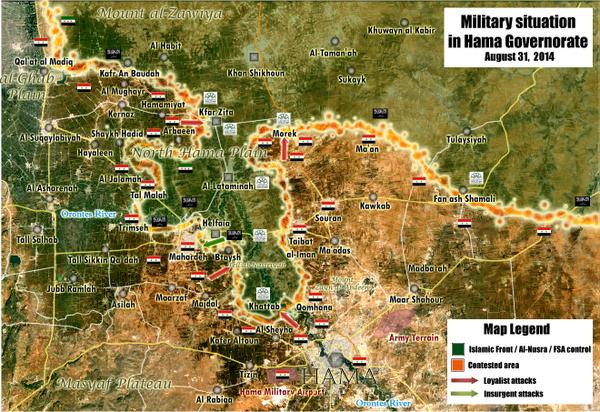
Why Al Kafat contexted in rural Hama?
It's deep under army held area on Hama insurgents are on north Hama
There is the map https://pbs.twimg.com/media/BwWhnb8IQAEwtCM.jpg
If you no showing here source / Visual evidence it must be back to red again --Pototo1 (talk) 14:26, 31 August 2014 (UTC)
Sources for put Any ad Dananir contexted in Homs
Any source or information about this place ? — Preceding unsigned comment added by Pototo1 (talk • contribs) 14:47, 31 August 2014 (UTC)
Eib in Daraa under insurgent control what is your source?
Eib in Daraa is on map under insurgent control but it look in too deep Army held territories what is the source who you used to put that on green? — Preceding unsigned comment added by Pototo1 (talk • contribs) 02:28, 2 September 2014 (UTC)
See the discussion on Suwayda province. Multiple sources given for several small towns in the hands of Beduin rebels and Jabhat al-Nusra fighters. --84.24.43.183 (talk) 07:44, 2 September 2014 (UTC) guest
- : Maybe this sourceHanibal911 (talk) 07:47, 2 September 2014 (UTC)
Tasil in Daraa contested what is your source? Tasil in Daraa is on map under contested control but it look too deep Rebel held territories what is the source you used to put that on contested? — Preceding unsigned comment added by 80.184.67.215 (talk) 08:34, 2 September 2014 (UTC)
Sarcasm aside, Pototo al Assad, the reason why Daraa looks wonky is because it and Quneitra province are ridiculously inaccurate because you and other editors are POV-pushing and ruining the map. — Preceding unsigned comment added by 80.184.67.215 (talk) 08:37, 2 September 2014 (UTC)
The pro Opposition SOHR is who made on this map the 95% of the changes I'm not who make Tasil on conflict but it's close to Nawa who is partiality under Army control --Pototo1 (talk) 13:00, 2 September 2014 (UTC)
Yeaaa Daraa and Quneitra have been outdated for months. Good luck barking up that tree though. I spent over a month pushing to show the rebel presence on the Lebanese border, in the Assal al-Ward and Ras al Maara area - and it was shot down, reverted constantly, despite near daily reports of conflict in the area, until syrianperspective published a map acknowledging the rebel presence. Boredwhytekid (talk) 19:36, 2 September 2014 (UTC)
- Zabadani is point and case. Government hasn't controlled it in over a year - on our map here, it was red until barely a month ago. Boredwhytekid (talk) 19:37, 2 September 2014 (UTC)
- What the heck are you talking about. At the conclusion of the Qalamoun offensives, literally tens of sources declared that the rebels had surrendered in Zabadani. I am not sure why it is even contested on our map to begin with. It is clearly government held territory. — Preceding unsigned comment added by 2602:30A:C01B:89F0:4C1F:A767:8E14:8CED (talk) 19:43, 2 September 2014 (UTC)
Exactly the point. The Qalamoun offensive still hasn't ended - take a peak at SANA, or SOHR, or whatever source you please. "Rebels surrendered in Zabadani" was eagerly interpreted as "Rebels surrendered Zabadani" - meanwhile, SANA continued (continues) to report "cleansing terrorist dens in Zabadani" and the like, and SOHR continued (continues) to report barrel bombing and street fighting in the city. Yet it went red and those reports were ignored for quite some time. Boredwhytekid (talk) 20:13, 2 September 2014 (UTC)
- http://www.al-monitor.com/pulse/security/2014/08/latest-updates-from-the-ground.html .. http://syriatimes.sy/index.php/news/local/14041-syrian-arab-army-kills-al-nusra-front-ringleader-in-zabadani-outside-damascus-destroys-large-number-of-terrorists-cars-outside-lattakia .. Did you even try to research the situation in Zabadani before you typed nonsense?
Look at you linking a .sy source and then talking about nonsense. Pototo go ahead and change Eib, you're right it's too deep in regime territory, and on that same note, change Nubl and Zahraa in Aleppo to green - they are way too deep in rebel territory to be regime held. Oh and Kefraya and Fu'ah. What about western Deir Ezzor city? That's super deep in IS territory, change that to black as well. Abu al Duhur air base? That's WAY DEEP in rebel territory, and we haven't heard news about that place in a while. Change it to green.
Idiot. — Preceding unsigned comment added by 80.184.67.215 (talk) 20:48, 2 September 2014 (UTC)
lol nice. I only posted a .sy to demonstrate the diversity of sources that support Zabadani's contested status
This anti government map showing this place in Daraa under Army control http://umap.openstreetmap.fr/fr/map/desyracuse-syria-civil-war-8-august-2014_14181#12/32.9472/36.3774 --Pototo1 (talk) 21:47, 3 September 2014 (UTC)
Jordan border
Some pro gov sources including visual evidences claim the Army cut some Supply Lines between Jordan, Quneitra. https://www.youtube.com/watch?v=N05Wh9sBWhk http://english.farsnews.com/newstext.aspx?nn=13930611000772 --Pototo1 (talk) 13:52, 2 September 2014 (UTC) -- It is not clear which modifications you are requiring. In any case it is a pro-gov source and the change would be relevant for the Daraa map.Paolowalter (talk) 22:07, 2 September 2014 (UTC)
Pro-gov source cannot be used for government gains and YouTube videos cannot be used as a source. — Preceding unsigned comment added by 80.184.67.215 (talk) 20:53, 2 September 2014 (UTC) It's not you tube this is the official Syrian TV report --Pototo1 (talk) 02:34, 3 September 2014 (UTC)
Oh it's a SANA report? Sorry man I thought you were using a pro-regime biased source, go ahead and make the change. — Preceding unsigned comment added by 80.184.67.215 (talk) 08:00, 3 September 2014 (UTC)
Tasil and Hamidiyeh (Golan)
Can Hamidiyeh go to contested: http://live.aljazeera.com/Event/Syria_Live_Blog
-- No. AlJazeera is pro-rebel a cannot be used. Nevertheless, I found similar statements elsewhere (SOHE I guess). Hamidiyeh should get a green ring around.Paolowalter (talk) 22:07, 2 September 2014 (UTC)
Also, back to the Tasil-case again. In the last days there have been several updates of this map along the lines: 'if there is no actual report of fighting anoymore, revert this contested city to red'. Tasil should - following this line of thought - go to green. There are no reports of fighting anymore, and it is deep inside rebel held territory. So: green. — Preceding unsigned comment added by 84.24.43.183 (talk) 21:18, 2 September 2014 (UTC)
- "Can Hamidiyeh go to contested", your source says clashes around the town, not in it, so no. — Preceding unsigned comment added by 2602:30A:C01B:89F0:4C1F:A767:8E14:8CED (talk) 22:00, 2 September 2014 (UTC)
Aljazeera English is very reliable.Alhanuty (talk) 02:30, 3 September 2014 (UTC)
Tell Brak to blue
https://pietervanostaeyen.files.wordpress.com/2014/09/2000px-syria6.png
This pro-opposition map(which is neutral in a area with only YPG/IS)says the town in held by a local tribe. — Preceding unsigned comment added by 177.204.92.34 (talk) 22:16, 2 September 2014 (UTC)
North Hama
According to this Pro-opposition map, al-Safsafiyah should go just red, and maybe Kafr Rumah to green since there are no clashes there, I highly doubt regime would bomb their own soldiers including Marat Numan. DuckZz (talk) 09:22, 3 September 2014 (UTC)
Jisr ash-Sghigour
I have read some articles about the tensions between Nusra and the SRF/Hazm in Idlib. I stumbled upun multiple articles from neutral sources claiming that Jishr ash-Shigur is held by Jabhat al-Nusra since three weeks. Checkpoints south of the city remain in SAA hands.
- AP/Yahoo source: http://news.yahoo.com/infighting-split-emerges-among-syrian-rebels-172309665.html
- Zaman source: http://www.todayszaman.com/son-dakika_al-qaeda-group-seizes-syrian-town-on-turkish-border_353777.html
- Al-Arabiya News source: http://english.alarabiya.net/en/News/middle-east/2014/05/25/Syria-s-Nusra-Front-targets-army-with-four-suicide-bombings-.html
Note: Al-Arabiya says that "Ariha and Idlib are SAA controlled", it doesn't mention Jisr ash-Shigur (a major city) as SAA held anymore.
- Syrian Observer note on clashes in a Alawite village close to Jisr ash-Shigur: http://syrianobserver.com/News/News/Rebels+Attack+Military+Bases+in+Maarat+alNuman
Note: on closer inspection, Ishtabraq is south of the main highway, and south of Jisr ash-Shigur. It was previously though that rebels did not operate in that area. They can only advance there if they have indeed taken over Jisr ash-Shigur.
This should mean: Jisr ash-Shigur to green with a red ring, Ayn al-Suda to full green. Checkpoints and army bases south of Jisr ash-Shigur along the hihgway stay red, no green circle since there's no report of serious clashes there. — Preceding unsigned comment added by 84.24.43.183 (talk) 09:27, 3 September 2014 (UTC)
-- Hardly ever read something more meaningless. Your sources are either outdated, or biased or irrelevant. We cannot draw conclusions on some place from figtingh elesewhere. Any change of status in Jisr ash-Shigur would be trumpetted by rebels, we would not miss it. No change.Paolowalter (talk) 13:29, 3 September 2014 (UTC)
Wishful thinking! if rebels conquered Jisr Ash-Shugur we would have heard about barrel bombings in the city, that would be at least an indication. Hasan Rizvanbegovic (talk) 14:56, 3 September 2014 (UTC)
- We'll have to keep an eye on it. Generally I agree with Pao and Hasan - there would have been more coveraged/reports of SAA bombarding the town if it had fallen. The yahoo link is interesting though, in that it states Jisr al Shughour was taken, but I haven't been able to locate any corroborating sources, or even the alleged claim by SOHR director. ISW and other sources attest to the ongoing fighting around the city http://iswsyria.blogspot.com/2014/07/rebel-operations-in-idlib-province.html. Boredwhytekid (talk) 15:32, 3 September 2014 (UTC)
Halfaya
According to documnet sy. Severe clashes occur between the Syrian army and al-Nusra Front in south Halfaya town .Halfaya should contested. source: https://www.facebook.com/documents.sy/posts/795285273867564176.42.115.40 (talk) 11:36, 3 September 2014 (UTC) --There are many reports about clashes South of Halfaya. There may be an issues of translations between 'South of Halfaya' (outside the city) and 'South Halfaya' (in the city). Better wait more robust sources. Paolowalter (talk) 13:29, 3 September 2014 (UTC)
deSyracuse and pietervanostaeyen
Once again I would like to invite all rational editors to IMMEDIATELY REVERT ANY EDITS THAT ARE MADE BASED EXCLUSIVELY ON MAPS CREATED BY RANDOM INDIVIDUALS. Absolutely preposterous. It is a farce to use these as primary sources. Boredwhytekid (talk) 19:20, 3 September 2014 (UTC)
- This map from pro opposition source And many editors have agreed to use the data from the pro government map to display success by rebels and vice versa. So stop hysterical and unfounded accusations. Hanibal911 (talk) 19:50, 3 September 2014 (UTC)
- If you had issues with these maps, you should have spoken out WAY before now. These maps have been in use on Wikipedia for a while now. Now it appears as though you are trying to stop regime gains acknowledged by these sources. Besides, in order to "IMMEDIATELY REVERT ANY EDITS THAT ARE MADE BASED EXCLUSIVELY ON MAPS CREATED BY RANDOM INDIVIDUALS", you would need a community agreement that these sources that you named are in fact unreliable on all fronts.
I have brought this up multiple times over the course of months. Anyone can create a map online. Are these individuals' maps or major media maps? Why do we assume these individuals' maps are more accurate than ours? Why are they classified pro-op? Do they have access to information that we do not? There are tons of editors on this page who scour the web for information about the Syria conflict daily - why are we assuming the editors of these random maps are somehow "in the know" about gov't or rebel advances that we, collectively, find no other data on anywhere on the web? BTW - I'm of the same opinion about syrianperspective maps.. it's not a partisan thing.. it's a, it makes no sense to overturn edits based on major media reports simply because one random individual's map shows a different color, thing. Boredwhytekid (talk) 20:06, 3 September 2014 (UTC)
It's amazing how illogical Hanibal's reasoning is here, and how obvious he is being about his pro-regime bias at this point. Boredwhytekid was not discussing whether or not deSyracuse claims to be pro-opp or not, since any random idiot can go online and claim to be whatever he wants. He's discussing the fact that WE HAVE NO IDEA WHO THIS GUY IS, WHAT HIS SOURCES ARE, AND ON WHAT BASIS HE IS MAKING HIS MAPS. Sources have to be RELIABLE, you can't use them just because you want to push your bias on the map. I can go make a website now, claim to be pro-regime, and create a map showing all of Damascus in rebel hands. It doesn't work that way, and anyone with half a brain who is trying to make an objective map will see what the problem is here. We can't even make a 100% accurate, very old, and well known change (Tasil to green) because of how overbearing the pro-regime bias is on this map.
Red green yellow or black circle around the town or village
Let's not clutter up the map and we will put a circle around the city only in the case if the city is besieged by so how often we put a circle on the basis of the reports of fighting near the city or in its vicinity. But we can not be sure exactly that the clashes were continuing, and maybe it is just had an attack and retreat. Circle can be installed around the city or village if for a long time we have a message that there clashes continued around these citys or villages. So that often on the map is set circle around the town or village but clashes around this settlement maybe has long been ended and this not right. Hanibal911 (talk) 09:02, 4 September 2014 (UTC)
-- We should consider removing the ring alltogether. They are of little use and generate a lot of discussion. Furthermore they are positioned almost at random. Let's just remove them. Paolowalter (talk) 20:28, 4 September 2014 (UTC)
Tasil and Jasim in Daraa contested: what is your source?
Can somebody show me a valid source from the past two months or so that indicates protracted fighting in the towns of Tasil and Jasim in Daraa province? I can't find any, so that makes this map inaccurate... --84.31.204.195 (talk) 14:41, 4 September 2014 (UTC) PolarBear
- I agree that we need note the city Jasim in Dara province under rebel control because no one from reliable sources not said that this city still contested. Because also the map from the pro government source in late May showed that this city under control by rebels. But if someone else has a source confirming that the city is challenged he need provide this source. Hanibal911 (talk) 18:59, 4 September 2014 (UTC)
- I turned Jasim contested based on SOHR news, I do not know how the situation changed since.Paolowalter (talk) 20:43, 4 September 2014 (UTC)
- Also the status of Shayck Miskin as contested. It used to be red but sometimes there are claims that bombs are thrown on the city and pro-gov map shows a pocket rebel controlled on the northern outskirt. I'd turn it red with a green little dot on the north side.Paolowalter (talk) 21:06, 4 September 2014 (UTC)
Paolowalter, that is complete nonsense. Shayk Miskin is a rebel held but besieged town, cut off from Ibbta in the south (minus some tunnels or back roads) by a string of army bases. Nawa is splitt in half between the rebels and the SAA. Jasim and Tasil are both under complete rebel control, but subjected to severe shelling because they are supply lines to rebels fighting around Nawa and Inkhil. Also, the rules of this map are very clear: if rebels hold even one building of a town, it is as a matter of fact contested. SOHR never said there was fighting in Jasim, only fighting on the outskirts ... which means propably the two hills southeast of the city that are under SAA control and used to shell the city and Nawa. — Preceding unsigned comment added by 84.24.43.183 (talk) 21:22, 4 September 2014 (UTC)
Contested and Besieged towns - Revert to solid color after a month or two of no information from any source
I have been a lurker to this page for a couple of years and I have a thought. Why not have a "Time date bomb" to cities that have a contested or besieged symbol on them. Say the cities or villages revert back to a solid color .... agreed to by the group ...... after a certain amount of time of not getting any info about fighting in the area. Active fighting gets press, lack of active fighting does not get any press. SO if the fighting has moved on the besieged and or contested symbology stays on the map forever. You can always reactivate the active symbol is fighting returns.
-- Because sometimes (e.g. Nawa) the city is actually split in two even of there is no fighting for a protracted amount of time. The other problems is that for small villages, quoted only occasionally, it is not clear who controls the town after the fighting. In any case, in general, barring the first case above (of actual splitting of the town), we shoudl revert to the old color after some time without reported fighting. Paolowalter (talk) 20:28, 4 September 2014 (UTC)
That is a good point about the split control. Then I propose that active fighting be delineated by an active contested symbol and split control with little to no fighting be delineated by a static contested symbol.
Tal Khazne in Homs why contexted ?
Anyone got any source why this was change to red to contested ? --Pototo1 (talk) 01:29, 5 September 2014 (UTC)
Tell Mahl in Hama to red, what is the source?
In Hama the town of Tell Mahl had been green until yesterday. Suddenly today it is red. No source is given. So, what is your source? If there is none, revert it to green. Thank you :) — Preceding unsigned comment added by 84.24.43.183 (talk) 11:59, 5 September 2014 (UTC)
most recent map from Hama https://twitter.com/PetoLucem/status/505988237777969152/photo/1 --Pototo1 (talk) 12:11, 6 September 2014 (UTC)
Sorry, revert to green. Reason: using pro-Gov Twitter source to show army gains. That is not possibly, as you yourself have often claimed based on pro-opposition maps showing a rebel advance. Revert to green please until neutral source indicates that change is certain.--84.24.43.183 (talk) 14:48, 6 September 2014 (UTC)
The map is outdated (August 31) but is the most recent who I know at the moment (I'm not very active on that now) . --Pototo1 (talk) 17:46, 6 September 2014 (UTC)
Still: pro-gov map cannot be used to show SAA advances. This map is a Syria Perspective map, pro-gov. Just like maps from Arab Chronicle are not used to show pro-rebel advances. So, green until a neutral source is provided... — Preceding unsigned comment added by 84.24.43.183 (talk) 19:27, 6 September 2014 (UTC)
- Source here Hanibal911 (talk) 19:37, 6 September 2014 (UTC)
Ah of course, no actual confirmation of the change so the deSyracuse trick is back to make an uncorroborated, untrue, pro-regime advance. Good job slimy editors. — Preceding unsigned comment added by 85.112.86.30 (talk) 17:00, 7 September 2014 (UTC)
Bteich Checkpoint
Bteich checkpoint should be green. It was recaptured by the regime on August 28th, but now appears to have been retaken by the rebels according to sources. For example:
http://eaworldview.com/2014/09/syria-daily-continuing-regime-assault-jobar-damascus/ — Preceding unsigned comment added by Darkknight30 (talk • contribs) 13:02, 5 September 2014 (UTC)
SOHR is consistently reporting clashes around Bteich. Maybe there's a case to mark it contested, but having it red with green ring essentially symbolizes the same thing. In any case, no pro-rebel edit will be made exclusively based on eaworldview. Boredwhytekid (talk) 13:26, 5 September 2014 (UTC)
I see your point and would accept contested. I don't see evidence that the regime is firmly in control of the checkpoint. — Preceding unsigned comment added by Darkknight30 (talk • contribs) 13:31, 5 September 2014 (UTC)
Indeed. Unfortunately however, since the last confirmed report of "who controlled it" said it was SAA controlled, and no source specifically stated that fighting is IN the checkpoint, there really isn't an ice cube's chance in heck of having it changed to contested. I'm not shooting you down or anything, just saying, the opposition to that proposal will be insurmountable until further sources are provided. Boredwhytekid (talk) 14:01, 5 September 2014 (UTC)
Quneitra
Mainstream Israeli news says rebels seized the old city http://www.ynetnews.com/articles/0,7340,L-4565454,00.html / http://www.jpost.com/Middle-East/Jabhat-Al-Nusra-unlikely-to-target-Israel-soon-senior-army-officer-says-374271
Mainstream (right wing) US news says SAA is bombing Quneitra http://latino.foxnews.com/latino/news/2014/09/01/islamist-rebels-syrian-forces-clash-near-golan-heights/
Random news reports rebels seized the old city http://www.jns.org/news-briefs/2014/8/29/new-video-surfaces-of-syrian-jihadists-seizing-golan-heights-border-crossing#.VAmp3E9OXOE=
Mind you the Israeli sources don't prefer Nusra to the SAA, so it's as unbiased as we're going to get. Not to mention that they can literally see it. Boredwhytekid (talk) 13:11, 5 September 2014 (UTC)
The reliablity of Israeli sources, mostly the IDF in this case, is questionable. The reality on the ground is that you have the IDF shelling SAA positions even when it was the rebels who shot at them and plus you got Israeli hospitals taking care of injured rebel fighters. Just based on this it makes enough of a case to consider Israel/Israeli sources biased towards the SAA. EkoGraf (talk) 14:30, 5 September 2014 (UTC)
That's a broad generalization. Israel has treated FSA and SRF fighters, yes, but not Nusra members - who constitute the predominant force in Quneitra as of late. The IDF and Israeli news are as anti-Nusra as they are anti-SAA. Boredwhytekid (talk) 14:46, 5 September 2014 (UTC)
Jews and Al Qaeda / FSA is the same scum. — Preceding unsigned comment added by 201.210.253.209 (talk) 16:22, 5 September 2014 (UTC)
How constructive. Boredwhytekid (talk) 17:21, 5 September 2014 (UTC)
Is true they are in same side. — Preceding unsigned comment added by 201.210.253.209 (talk) 17:43, 5 September 2014 (UTC)
- But on 1 September another source reported that clashes resumed in area where the militants have wrested control of a key frontier crossing and it was not clear whether the Syrian army had managed to retake control of the Quneitra crossing.Al Akhbar Hanibal911 (talk) 18:22, 5 September 2014 (UTC)
That source does not talk about Quneitra's old city, so it has no relevance at all to this topic. Boredwhytekid (talk) 18:27, 5 September 2014 (UTC)
Al Akhbar is a Hezbollah media outlet...pretty sure you know that Habibal...keep up the good work slimy. — Preceding unsigned comment added by 85.112.86.30 (talk) 17:04, 7 September 2014 (UTC)
Jobar
 | It is requested that an edit be made to the extended-confirmed-protected module at Module:Syrian Civil War detailed map. (edit · history · last · links · sandbox · edit sandbox · sandbox history · sandbox last edit · sandbox diff · transclusion count · protection log) This template must be followed by a complete and specific description of the request, that is, specify what text should be removed and a verbatim copy of the text that should replace it. "Please change X" is not acceptable and will be rejected; the request must be of the form "please change X to Y".
The edit may be made by any extended confirmed user. Remember to change the |
according to pro-Government source, Jobar is under opposition full control. 2.88.63.55 (talk) 13:19, 5 September 2014 (UTC)
Not really. You have the northeast section around the mosque area which has been captured by the SAA. EkoGraf (talk) 14:34, 5 September 2014 (UTC)
- Yeaa. It usually plays out that I'm the default advocate for showing rebel gains, because no one else plays the part, which is unfortunate, but I'm 100% with EkoGraf on this one. Boredwhytekid (talk) 17:24, 5 September 2014 (UTC)
Talbiseh
SOHR reported that clashes took place between regime forces and Islamic battalions in the western side of city Talbisa.SOHR Hanibal911 (talk) 17:59, 5 September 2014 (UTC)
- That post says "clashes took place between regime forces and Islamic battalions in the western side of Talbisa city". You JUST TODAY reverted a green ring around Salamayn based off of this SOHR post https://www.facebook.com/syriahroe/posts/578906808884328 that says "Violent clashes took place yesterday night between the regime forces and the Islamic battalions in the southwest of al Sanamin town" - you said, and I quote, "SOHR said that there were clashes east of the city but the source said that the collision is near the town". Boredwhytekid (talk) 18:47, 5 September 2014 (UTC)
- No need to compare! The difference is that in the case of the city Al Sanamayn SOHR said that violent clashes took place yesterday night between the regime forces and the Islamic battalions in the southwest of al Sanamin town and in Samlin.here But in the case of the city Talbiseh SOHR said that clashes took place between regime forces and Islamic battalions in the western side of Talbisa city.here But even now I do not insist that the city should be marked as contested. Hanibal911 (talk) 18:30, 5 September 2014 (UTC)
So, what's your point? Boredwhytekid (talk) 18:32, 5 September 2014 (UTC)
- I just added information on the talk page to we tracked the situation in the city. Hanibal911 (talk) 18:46, 5 September 2014 (UTC)
I see. You have to admit, it's a bit duplicitous though - the red circle went up around Talbiseh based on an SOHR post that used THE EXACT SAME LANGUAGE https://www.facebook.com/syriahroe/posts/548848095223533 "clashes against the regular forces in the western side of Talbisa". Yet SOHR reports the same about Salamayn and... nada. Boredwhytekid (talk) 18:52, 5 September 2014 (UTC)
- Hey guy now you refuse to understand that you are not right. And a red circle around the city Talbisa was raised as a compromise because SOHR also reported about clashes in the city but we have agreed to this compromise because except SOHR no longer one of the reliable sources not reported about clashes in this city. And two big differences when the source said about clashes in the southwest of town and if source said that the clashes in the southern part of the city. Hanibal911 (talk) 19:06, 5 September 2014 (UTC)
- Also, I suggest in the future used to edit only the information which was taken directly from site SOHR but not from the page in Facebook. Hanibal911 (talk) 19:16, 5 September 2014 (UTC)
- (: you read into it whatever you want. When it's Talbisa, a gov't advance, "in the southern part of the city" is enough to make an edit. When it was Halfaya, a rebel advance, day after obstinate day you refused to use SOHR reports of the SAA bombing and shelling the city https://www.facebook.com/syriahroe/posts/573047822803560, https://www.facebook.com/syriahroe/posts/573384699436539. All I'm saying is let's try to avoid the Halfaya mistake - where we ignored reports of clashes so long that we missed the entire contested stage and ended up switching it straight from red to green. Boredwhytekid (talk) 19:22, 5 September 2014 (UTC)
my opinion is that hanibal is great guy. he always take some time before changes something. i don't believe that some of you have courage to attack him. from start he was objective and always listen two sides. it is not his problem because assad is gain and gain more teritories. — Preceding unsigned comment added by 37.122.168.24 (talk) 18:43, 8 September 2014 (UTC)
Mashara, Quneitra
| It is requested that an edit be made to the extended-confirmed-protected module at Module:Syrian Civil War detailed map. (edit · history · last · links · sandbox · edit sandbox · sandbox history · sandbox last edit · sandbox diff · transclusion count · protection log) This template must be followed by a complete and specific description of the request, that is, specify what text should be removed and a verbatim copy of the text that should replace it. "Please change X" is not acceptable and will be rejected; the request must be of the form "please change X to Y".
The edit may be made by any extended confirmed user. Remember to change the |
The first thing I saw were pro-rebel tweets saying rebels took control of this village, and then SOHR wrote that Syrian jets are targeting this village. Tweet1 Seized weapons Syrian Airstrikes 109.175.65.25 (talk) 20:39, 5 September 2014 (UTC)
Contested. EkoGraf (talk) 01:50, 6 September 2014 (UTC)
- According to https://www.facebook.com/documents.sy/posts/797385220324236 SAA gaining ground in Mashara.Paolowalter (talk) 19:22, 6 September 2014 (UTC)
Quneitra province
This section is mainly for changes in this region as clashes intensified between insurgents and Syrian Army. My first suggestion is to change the status of Tel Krum, shown here as a town/village, but actually it's just a checkpoint, as you can see on wikimap. Also new rebel map for this region, use for government advances, althought the map is much different than here.DuckZz (talk) 22:22, 5 September 2014 (UTC)
There are TV reports from the situation in Quneitra https://www.youtube.com/watch?v=OThKX-j_XFQ https://www.youtube.com/watch?v=ldD5jCET8LU https://www.youtube.com/watch?v=oHcHB76aXqs https://www.youtube.com/watch?v=VF0mgT63a34 https://www.youtube.com/watch?v=eMX5xEmzG4Q https://www.youtube.com/watch?v=3GsyMuG3K9s nothing especial basically seems insurgents are attacking the province in direction from Israeli with a bit Israeli artillery support Held territories Army send the troops from Damascus this is not the first time when this happens anyway --Pototo1 (talk) 12:40, 6 September 2014 (UTC)
Heteta al-Jersh
Government forces captured Heteta al-Jersh [7]. Please add it to the map. I think its near Zabadin in the Qalamoun area but not sure. EkoGraf (talk) 01:49, 6 September 2014 (UTC)
- It is in Easternm Ghouta, east of Maliha, north of Zebdeen. is name in wikimapia is Hatita Al Jarsh. It is located in the Damascus map. I have already asked to update the map.Paolowalter (talk) 07:24, 6 September 2014 (UTC)
sohr says saa capture Heteta al jersh: https://www.facebook.com/syriahroe/posts/579212688853740 Heteta al jersh location: http://wikimapia.org/#lang=tr&lat=33.490408&lon=36.390324&z=14&m=b&gz=0;363880920;334853258;17166;119538;219726;126696;243759;41518;24890;0;0;122401;100421;123117 — Preceding unsigned comment added by 195.155.233.226 (talk) 07:25, 6 September 2014 (UTC)
And we should change darayya: https://www.facebook.com/syriahroe/posts/579305658844443195.155.233.226 (talk) 08:46, 6 September 2014 (UTC)
- Too early. Negotiations are underway. The source just presents the requests of the rebels. At the moment there is only a ceasefire. We will follow the evolution of the discussion between rebels and government.Paolowalter (talk) 10:05, 6 September 2014 (UTC)
Hasakah map?
I haven't been on this template/page in a while, and I am curious to know as to why the Hasakah map was removed?—SPESH531Other 04:47, 6 September 2014 (UTC) We concluded that the city is governed in collaboration between the government and YPG, between which there have not been clashes since the beginning. Therefore the separation of the city in two section did not correspond to reality and we went for a joint administration.Paolowalter (talk) 07:42, 6 September 2014 (UTC)
Because some dumbs users decided put all Hasakah City under the Kurdish insurgent control that's because some members decided but that in truce / Shared control --Pototo1 (talk) 17:48, 6 September 2014 (UTC)
Bases in eastern damascus + rebel held territory in NW damascus
Hello! I am just a reader, not an author. I noticed that there were 2 rebel-held bases in the east or damascus province (see here: http://en.wikipedia.org/wiki/File:Syrian_civil_war.png). Why have they been removed? Is the linked map out of date? Another thing that I don't understand is the little rebel area NW on the damascus map. Is this really still rebel-held if the 2 dots right outside the map are regime-held without being contested or having a green circle? Both questions just for me to understand what the map is actually showing and no proposals for changes at all! Thanks in advance!--Andylee Sato (talk) 09:23, 6 September 2014 (UTC)
Those bases where captured by the rebels maybe some 3/4 months ago and remain that way. They are in the middle of the desert, so the rebels can easily go across the regime held territory around it. Anyway, unless some pro-regime dude presents a source for it not being rebel, it should stay green. — Preceding unsigned comment added by 189.26.154.167 (talk) 10:54, 6 September 2014 (UTC)
The base who you are talking about were not a military base at all basically small army depots from reparation of vehicles according to videos who the insurgents uploading on you tube, the insurgents uploading these videos after get defeated in Qalamoun area including Yabroud
According by site rules you tube is not a source for draw bases / Towns the zone allegedly taken by Insurgents is in a deep controlled army territory the insurgents no controlled a single town in the zone when is this allegedly Army place who they claim to take.
I no deleted these places anyway. --Pototo1 (talk) 17:51, 6 September 2014 (UTC)
This has to be a joke. There was like, a HUNDRED sources at that time. If I ask you to give me sources of the regime taking control of a small village in 2011, will you have it? Ridiculous. Add those bases back, they we're accepted at that time, you CAN'T exclude then simply because you want it. Ridiculous. Pathetic. The rebels control those bases and unless the regime proves to hold those bases, they need to stay rebel held. Your pro-regimeness is making not only this map look ridiculous, but is getting out of control — Preceding unsigned comment added by 189.26.154.167 (talk) 21:45, 6 September 2014 (UTC)
- : Done Boredwhytekid (talk) 15:39, 7 September 2014 (UTC)
agree with SineBot. For months now, this map has become more and more a pro-SANA paper. Towns are made contested or red based on sources from SANA or SOHR or Twitter even. But as soon as a red town needs to become contested or green, the world isn't small enough for some editors here. SOHR ... not good enough. Twitter? No source. Source on a website? Well, that is biased and we should wait for a neutral source. There are MAJOR wrongs in this map on Western Qalamoun, Daraa, Qunaitra and maybe even Idlib. It's a shame that this bueatiful map meets this fate. — Preceding unsigned comment added by 84.31.204.195 (talk) 13:20, 7 September 2014 (UTC)
- Sinbot is the one who signs unknown comments, he is not an actual user. As for "There are MAJOR wrongs in this map on Western Qalamoun, Daraa, Qunaitra and maybe even Idlib", tell us what those MAJOR wrongs are and back them up with reliable,current sources [Not YouTube videos like most people try to do] so that we can make them RIGHTS.
Also, I would like to see ONE pro-regime edit made on here based on SANA. — Preceding unsigned comment added by 2602:30A:C01B:89F0:4C1F:A767:8E14:8CED (talk) 14:47, 7 September 2014 (UTC)
Template:Syrian and Iraqi insurgency detailed map
I've just set up Template:Syrian and Iraqi insurgency detailed map. It shares its points with Module:Syrian Civil War detailed map and Module:Iraqi insurgency detailed map, so any changes to either of those will also update it automatically. Jackmcbarn (talk) 00:41, 7 September 2014 (UTC)
Rebels take over Brigade 90 in quneitra.
https://www.youtube.com/watch?v=Bg71nHy7u5k — Preceding unsigned comment added by 84.135.37.49 (talk) 14:06, 7 September 2014 (UTC)
- Pro opposition video from YouTube this not reliable source need confirmation from reliable source. Hanibal911 (talk) 14:14, 7 September 2014 (UTC)
Not true, and here's why. a) According to pro-rebel map, rebels are to far away from that base, they haven't even taken Jaba town. b) According to pro-rebel map, rebels have reached Nabi al Sakr, there you have two smaller checkpoints with weapons, some of them do belong to the brigade 90, but it's not the "brigade 90 army base", that one is much larger. So the location of this base is probably here.
As for all, we need some neutral or at least "obvious" rebel sources, can't see much going on twitter.DuckZz (talk) 14:23, 7 September 2014 (UTC)
Saw this video from Al Jazeera about Quneitra and Golan situation, at 2:40 they said rebels have taken the city of Um Batinah and are not attacking Tell Krom. Also pro-rebel map shows this city deep behind rebel lines.DuckZz (talk) 14:52, 7 September 2014 (UTC)
More sources for rebel gains in Qunaitra (with extensive video evidence):
- https://malcolmxtreme.wordpress.com/tag/majduliyah/ (Ayn al-Basha, Majduliyah). Ayn al-Basha should be Ayn Ayshaa on our map
- http://eaworldview.com/2014/09/syria-daily-insurgent-offensive-southwest/ (Majduliyah hospital in town taken by rebels, backs source 1)
- http://www.middleeasteye.net/news/syria-rebels-advance-near-golan-heights-1954231684
- http://www.dailystar.com.lb/News/Middle-East/2014/Sep-07/269839-syria-rebels-advance-near-israeli-occupied-golan-heights.ashx#axzz3Ce4zFpee
This source backs claims that rebels control towns and hills around the crossing, that are shown contested on this map. The article can also be seen as supporting sources mentioned above by rebel gains around Majduliyah (several hills there, look it up on Google Maps).
So that means:
- Quinaitra and Qathaniyah to green
- Majduliyah to green
- Ayn Ashaa to green (or maybe contested)
I am unsure about Rasm al-Shayd and Rasm al Kharrar. It seems to me those two small towns west of Naba al-Sakhr should be green, as this is a logical supply route. Also, rebels are already fighting further north, as shown on this map. — Preceding unsigned comment added by 84.31.204.195 (talk) 15:57, 7 September 2014 (UTC)
- Eaworldview and Today in Syria this is pro opposition sources and cant be used to display by rebel advances. And rebels captured only Quneitra old city but not taken new city Quneitra. And Daily Star or Middle East eye not said that rebel captured city Majduliyah and Ayn Ashaa. And not need invent information or provide pro opposition sources but you only need provide confirmation of your data from reliable sources. Hanibal911 (talk) 18:04, 7 September 2014 (UTC)
New source on Qunaitra in rebel hands: http://www.houstonchronicle.com/news/nation-world/world/article/Islamists-advance-against-Syrian-forces-in-5737106.php This must be the new city, since there are no hills near the old city. So: green. — Preceding unsigned comment added by 84.24.43.183 (talk) 18:11, 7 September 2014 (UTC)
- Your source only said that Islamists advance against Syrian forces in Quneitra. Source meant that Islamists advance against Syrian forces in Quneitra province but not in the city Al Quneitra. They taken the Quneitra border crossing and old city Quneitra .Khaleej TimesHanibal911 (talk) 18:24, 7 September 2014 (UTC)
You are more cleary biased every day, you know that? This is the text of the news source: Fighting has raged in the province since August, when rebels and the Al Qaeda-affiliated Al Nusra Front took control of a border post. “Rebels have since taken control of hills overlooking the border post, as well as several villages nearby, (after battles that killed) a large number of troops on both sides,” Syrian Observatory for Human Rights director Rami Abdel Rahman said Sunday.
So, we check wikimapia for the border post location: http://wikimapia.org/#lang=en&lat=33.133886&lon=35.874310&z=14&m=b Do you see any other towns nearby then Qunaitra and Qahtaniyah? I don't. Also, Twitter source with video conforming the roundabout east of Qunaitra has already been taken by rebels. Second, if both towns around the crossing are contested, how could rebels ever take the crossing? Surely they didn't come from Israel, so at least one of the two towns was already under rebel control prior to the attack. Hundreds of fighters don't just pop up in the Golan Heights.
Video report from Mamtinah by rebel fighters: https://www.youtube.com/watch?v=njuBwqZ0Sb0 Five minutes of video with very clear buildings and streets that can be checked through Wikimapia or Google Earth. You can easily trace the entire village. Proof enough? Of course not, since this is a pro-opposition source. But I bet ... as soon as a report arrises concerning a town under SAA attack it's made contested or colored with a red ring. To obvious ....
Yet another source for Qunaitra and Qathaniyah to green: http://live.aljazeera.com/Event/Syria_Live_Blog/126047900 :) --84.24.43.183 (talk) 12:11, 8 September 2014 (UTC) PolarBore
- Your Source only reported that Syrian rebels have made fresh advances near the Israeli-occupied Golan Heights in Quneitra province. And said that rebels have taken control of hills overlooking the border post, as well as several villages nearby, after battles that killed a large number of troops on both sides," Syrian Observatory for Human Rights director Rami Abdel Rahman said Sunday. But not said that rebels captured new city Quneitra or village Qahtaniyah.
We cant change the status of the town or village based only on assumptions. Need more data that clearly tell which the village or city captured by rebels and if you provide such information, I immediately note it on the map. Hanibal911 (talk) 12:34, 8 September 2014 (UTC)
Come on ... Jezus ... look it up on the maps. There are only two towns near Qunaitra crossing: Qunaitra city and Qathaniyah. No other towns. Compare that with dozens of HQ videos of the fighting itself, and the conclussion should be obvious to everyone ... except maybe this map makers :) — Preceding unsigned comment added by 84.24.43.183 (talk) 14:30, 8 September 2014 (UTC)
Hanibal911
I suggest that we revoke the rights of Hanibal911 to edit on this page. He consistently edits with pro-regime bias and has led this map to become a mouthpiece for the Syrian government. This map is an embarrassment to Wikipedia.92.28.192.87 (talk) 19:39, 7 September 2014 (UTC)
- I'm not trying to edit in favor of one side of the conflict so that it is not necessary to make unfounded accusations. I'm just trying to put in order the map. Also if you look at the history of editing you can see that I have removed most of not justified red circles around the towns and villages which now under control by rebels.here Hanibal911 (talk) 19:52, 7 September 2014 (UTC) — Preceding unsigned comment added by 2602:30A:C01B:89F0:4C1F:A767:8E14:8CED (talk)
- Your Right!!! Let ban the veteran editor Hanibal because he does not agree with us!!! He is obviously on regime payroll!! While we're at it, lets purge the map of all editors that dare change a city to regime control!![Can you feel the sarcasm] Seriously though, you cannot revoke the right of an editor unless he breaks the rules. Also you cannot ban an editor for not agreeing with you. How would you like it if I requested you be banned because you are the "rebel's mouthpiece"?
Still, I would like a honest discussion. This map is biased towards the regime, if you want to see it or not. Towns are made contested or besieged by the Syrian Army based on facebook posts. Maps of Syrian Perspective are used in Hama to advance the red dots, whilst Syrian Perspective is clearly pro regime. Extensive video evidence, twitter reports and even some mainstream media around Daraa and Qunaitra are shot down because they are 'not concrete enough sources' to change the map. I will list what's wrong with southern Syria only:
- Tasil is not contested, but rebel held. No source in the past two months justifies holding it constested
- Same for Jasim, even pro-SAA maps show it as rebel held, it's still contested here
- Edits in Qunaitra are only done after every possible delay is taken into account to ensure there is realy no SAA presence there
- small loyalist villages are added, but rebel held villages of the same size west of Nawa of north of Busra al-Harir aren't
- Daraa prison/grain silo's are rebel held but not showns as a army base (which it was), regime checkpoints of smaller significance are
- Towns in eastern Daraa near the Jordanian border are not shown on the map, just because they are rebel held, the same does not go up for small loyalist villages near Al-Qusayr in Homs
The list is growing rather alarmingly in the past three months. — Preceding unsigned comment added by 84.24.43.183 (talk) 20:01, 7 September 2014 (UTC)
- Tasil is rebel held - way behind the front line and no reports of fighting in months, plus plenty of video evidence that shows it's rebel held
- Hannibal has massively, unwarrantedly, resisted the display of rebel advances in Hama province and Daraa province - refusing to use clear-cut SOHR reports of rebel advances whilst turning around and accept SOHR reports 100% for SAA gains (how the situations in Qalamoun/Assal al-Ward area and Halfaya, Hama were handled on this map, primarily due to Hanibal's resistance to any pro-rebel gains, was absolutely atrocious and made/makes this map look like a complete joke) .
- I 100% agree that user Hannibal edits on a pro-gov't slant. It's only because of the flagrantly pro-gov't edits that I end up looking pro-rebel, because no one else is proactively, honestly, adding the rebel gains. That being said, user Hannibal is - without question - one of the most productive and thorough editors. While I am completely convinced that he edits pro-gov't whenever possible, I cannot and will not deny that 75%+ of his edits are legit in my book. (Thank you Hannibal) #1 complaint - STOP USING RANDOM INDIVIDUALS'S MAPS AS PRIMARY SOURCES! Boredwhytekid (talk) 20:55, 7 September 2014 (UTC)
Hanibal's pro-regime bias is so visible that this section really does not need much explanation, just a quick look at the sources he uses to confirm gov. advances, and hypocritically his arguments against any and every source that shows the slightest rebel gain. Hanibal and Pototo have single-handedly made this map utterly inaccurate and useless for anyone who wants to better understand the fighting going on in southern Syria due to their refusal of almost any source showing the slightest rebel gain while at the same time adamantly using the most dubious sources to show SAA gains - as Boredwhytekid has stated, he is using a completely random and unverified map from some "pro-opp" person's website who we know nothing about other than the fact that he claims to be pro-opp and seems to produce maps that show sweeping gains for the SAA in a region (Daraa-Quneitra) whereas literally every other trustworthy international media outlet in the world is reporting SAA losses in this region. The fact that Tasil and Jasim - rebel hubs for probably longer than a year now - are still marked as contested, speaks for itself. The fact that Hanibal's refusal to change these towns to green is based on "no reports in months" contrasts greatly with the fact that he used this exact same reasoning "no reports in months" to revert towns in/close to Suwayda back to red really says it all. I don't know if he should be removed as an editor but a warning is certainly in order. As for Pototo who is most likely a regime-affiliated Syrian himself and has never made a proper edit on this map well, he indeed should be revoked from editing the map. — Preceding unsigned comment added by 85.112.86.30 (talk) 22:00, 7 September 2014 (UTC)
- Once again, you cannot ban editors unless they break the rules. Hanibal is by far one of the most senior and valuable editor on this map. Also, you are being way too vague with statements like "he claims to be pro-opp and seems to produce maps that show sweeping gains for the SAA in a region (Daraa-Quneitra) whereas literally every other trustworthy international media outlet in the world is reporting SAA losses in this region". On Wikipedia, we have no room for vagueness. Everything must be substantiated by reliable sources. If you know of so called SAA losses in these regions, you have to back them up with SPECIFIC articles. Also, hurling ridiculous accusations at other editors like Pototo like him being " a regime-affiliated Syrian " does not help your case in presenting yourself as the unbiased editor. The system on Wikipedia is very simple, reward the regime with opposition sources, reward the rebels with regime sources, or reward both with neutral sources, and above all, NO YOUTUBE VIDEOS. Finally, Daraa and Quneitra are by far the most difficult regions to edit. Rebels crank out propaganda about events here more than any other. Many times have I heard stories about 80%+ of quneitra being under rebels control [clearly not true], rebels controlling the whole Israel-Syria boarder [also not true],of 1000's of SAA defections and casualties in Daraa [If this is true, how is the regime still alive in daraa?], and the looming "Southern Front" [where is it!]. Hanibal is doing the right thing and being cautious when editing here, rather than accept a single sentence from SOHR. Simply follow the above guidelines for editing and hanibal will not bother you. If you want Jasim and Tasil to be rebel-held, YOU NEED A RELIABLE SOURCE!2602:30A:C01B:89F0:4C1F:A767:8E14:8CED (talk) 23:30, 7 September 2014 (UTC)
- Exclusively a comment on your "vagueness" point - I would urge you to look into the specific cases of Qalamoun/Assal al-Ward and Halfaya, Hama. Assal al-Ward: SOHR and other sources were referencing fighting in the area were ignored for MONTHS, until a syrianperspective (sic) map confirmed a rebel presence in Qalamoun; Halfaya, where SOHR reports of the SAA bombarding and barrel bombing the town AND a (pro-gov't) syrianperspective article talking about rebels attacking Mhardeh THROUGH Halfaya were, combined, still rejected as not proof enough to mark the town contested.
- I still stand by my above statement that I have no contest with 75%+ of Hannibal's edits. I'm commenting exclusively on specific topics/trends.. Boredwhytekid (talk) 23:59, 7 September 2014 (UTC)
I'm sorry, but in what world, in what academic circles, in what encyclopedia is the onus not on the person using a source to first make sure the source is corroborated and accurate before using it? I'm not making a vague claim - I'm talking about the use of the deSyracuse map which we have discussed several times now on the talk page. It's a bit naive of you to say something like "The system on Wikipedia is very simple, reward the regime with opposition sources, reward the rebels with regime sources" as if all sources are created with the same accuracy. If I say that SOHR is more accurate than SANA and regularly reports regime advances, this is not me being biased towards the rebels, it is stating a fact. If I say that the language used in many pro-regime outlets (rats, vermin, terrorists) casts a shadow of doubt on said outlet's ability to produce trustworthy news, this is not me being biased, but stating a fact. This so-called golden rule is the reason why this map was always one week behind during the battle in northern Latakia, and it is the reason why Daraa and Quneitra are now inaccurate by months. This is all, however, not what we are currently arguing about. What we are arguing about is the fact that the editors are bending these rules to show regime advances, while upholding this rule and even making new rules to make sure that rebel advances are not shown. As we have said: Regime towns in Suwayda were returned to red literally within a day after the end of fighting because "we have not heard reports of fighting". Tasil on the other hand, has not had reports of fighting in months, is clearly behind rebel lines and is rebel controlled even according to pro-regime maps, and is not being turned to green because ????. Anyone denying this is a problem needs to wake up. — Preceding unsigned comment added by 85.112.86.30 (talk) 09:43, 8 September 2014 (UTC)
And just a final (dark) humorous point to end my rant: when the IS had taken Tabqa airbase, there was a red ring around the base for a couple of days. Why? Because some poor SAA soldiers had managed to retreat to some small hamlets before being found and slaughtered by the IS. Being marched across the desert in your underwear and retreating with nothing but the clothes on your back is now considered "besieging" according to some of these veteran, unbiased editors. — Preceding unsigned comment added by 85.112.86.30 (talk) 09:51, 8 September 2014 (UTC)
I think we should not attack just Hannibal, although I agree with the assessment that he is not neutral. Today I looked up this map and saw in Qunaitra province two hills added as regime checkpoints, just to add more red to the map. Should this mean that every hill the rebels captured in Qunaitra and Daraa should be added also? Let's see ... two hills near Naba al Sakhar, the hill near Qunaitra, hills south of Jasim ... this is total madness. — Preceding unsigned comment added by 84.24.43.183 (talk) 08:48, 8 September 2014 (UTC)
- We not use the pro opposition map to show the rebel successes as well as we not use the pro government map to show progress of the army. And I added them on map not as the hill but as military objects because on the pro opposition map they are marked as army base. And if you are not familiar with editing rules do not need to accuse me of bias. Also if the pro government sources or one of the reliable sources say about the success of the rebels then I mark this on the map but also if pro opposition sources or any of the reliable sources say about the success of the army I mark this on the map. Hanibal911 (talk) 10:01, 8 September 2014 (UTC)
If you guys dont like this map, Go follow stupid archicivilians or arabthomnes maps.Or you guys create a map and make map all green.Hanibal or others mostly use sohr (PRO OPP.) ,And you guys still crying.I support haniball.195.155.200.75 (talk) 11:10, 8 September 2014 (UTC)
I would urge all who have here registered a complaint to fastidiously monitor all edits, ensure valid sources are being used, and dig up/provide sources for changes that make the map more accurate. If you truly want to curb bias, if you want to make the map better, don't stop at typing out a rant - scour for sources, and check the legitimacy of ones used for edits. Boredwhytekid (talk) 12:54, 8 September 2014 (UTC)
Ok to those who think this is a pro-gov map they must be with an IQ of 10.Have you seen the sources that we use I mean god damn it they are 90% form SOHR or other opposition sources quoted by MSM.We have never used SANA or PressTV or any other source that i so called pro-regime source for edits.So if you don't have any sources(TWITER and AMATEUR YOUTUBE FOOTAGE AND OTHER AMATEUR SHIT ARE NOT SOURCES) that prove you are right I suggest you get the off this page.Daki122 (talk) 12:57, 8 September 2014 (UTC)
As a fellow reader and user I'd have to say Hannibal's work is tremendous. He respects all rules of editing. All editors are allowed to have an opinion on this conflict but this must not interfere with the work that's being done here. As for Hannibal: Hats off! ChrissCh94 (talk) 16:23, 8 September 2014 (UTC)
Support for Hanibal from my side, even though I'd like to use some pro-rebel sources, he's the only one who truly follows the rules.DuckZz (talk) 19:50, 8 September 2014 (UTC)
I second the above statement. Hanibal is one of the best editors at this map and does not deserve to be blackmailed by frustrated people. Whoever you may support, the civil war can't be "won" on this wikipage, so instead better help to make this map accurate. Accurate with proper sources and not with biased youtube videos or other amateur stuff. Major kudos to Hannibal and the other editors who work on the credibility of this map. Heisenberg99 (talk) 20:53, 8 September 2014 (UTC)
Hanibal needs to bee revoked or even banned from editing, all the suggestion made are commented and changed by Hannibal. he does have Pro-government bias. He is reluctant to everything that would admit what is happening in the ground especially if it was IS advance to some degree Rebel advances. and very eager to put SAA advance or add areas to the map with significance to show They are under SAA are YPG control. I mean there are more dots in Ain Arab - YPG's part of Hasaka and Sinjar than dots in entire Iraq-Syria map Combined. Not to forget the circle around Tabaqa Airbase and 121 Milibia Base. Syrian soldiers were been dragged in their underwear and IS guy was standing on the wing of the MIG and there was red circle around Tabaqa. I just want to tell Hannibal that soldier soldiers in underwear were running to besiege the airbase..LOL
Look kid.We use circle when fighting around the town-base or when this place under siege.Sohr says is and saa fighting around the base so editors add red circle around the base.You should learn the rules first(need brain).Haniball is one of the best editors at this map and he mostly use sohr(pro OPPOSITION).And you little f*king kids still talking.I support you hannibal.Dont listen these little brainless jihadists92.44.169.34 (talk) 08:16, 9 September 2014 (UTC)
Look child you are the biggest idiots IP 92.44.169.34|92.44.169.34 in the history of Wikipedia. there were videos of detained soldiers in underwear and videos of IS chilling in the Aribase . SANA was saying they are evacuated the base assembling in a nearby village, IS twitter accounts were saying the soldiers are in some nearby village and they are trying to cut off their escape. You are dumbest person to think towns are besieged that way and that is not even fighting around the base but you obviously lack the same thing you taking about(brains) if you see videos of IS inside the base chilling and want to circle the base for SOHR article that was many days old. you probably have a turd for a brain. LOL — Preceding unsigned comment added by 72.208.239.127 (talk) 02:35, 10 September 2014 (UTC)
- You probably do not carefully watch because many reliable sources confirm the retreat of the rebels.Yahoo NewsThe Jordan TimesNaharnetThe Daily StarDAWN NewsAl Arabia Also SOHR said that regime forces recaptured Zor Balhsein area and the town of Khattab located in the west of Arze and Kherbet al Hjame villages after violent clashes with Jundo al Aqsa and the Islamic and rebels battalions. They also recaptured the two areas of Zor al Masaleq, Zor al Jdid.herehere and also source said that regime forces backed by fighters from the National Defense took control over the city Khattab. www.syriadirect.org/rss/1546-new-update-9-9-14 So anonymous editor which have IP adress [https://en.wikipedia.org/wiki/Special:Contributions/ stop make delusional statements and no need of insult other editors, even if they you do not like or you do not agree with them. Hanibal911 (talk) 06:38, 10 September 2014 (UTC)
IS capture tabqa airbase 2 weeks ago.After they capture sohr reported fighting around the base.So editors put a red circle around the base.We dont use videos or twitter to change map.Learn the rules or stfu.And you support ISIS and talking about brain.LOL.AWBW (talk) 07:09, 10 September 2014 (UTC) There were clashes around and inside Hasaka but there were no black circle around it. There were clashes Hama and there still are and there is no green circle around it. Hanibal is Pro government editor and everyone knows that. Hanibal eager to put Khatab say that Khatab was in regime hands while rebels were in khatab taking ammo from there an dusing it to it airbase. and AWBW you are an idiot. national Defense Facebook was used as source for khatab claiming that it is under regime. nad you saying no twiiter account if they are pro-regime. so you better stfu because you dont even follow your own rules(desperate Basharist)
- Stop talking nonsense no one reliable source not said about clashes in town Hama. And if you stop making unfounded accusations and look closely you will see that SOHR also confirmed that army captured city Khattab and many other villages.herehere this data also confirmed many reliable sources.The Daily StarAgency France PressThe Jordan TimesNaharnetAl Arabia and biased pro opposition source said that regime forces backed by fighters from the National Defense took control over the city Khattab. [www.syriadirect.org/rss/1546-new-update-9-9-14 Syria Direct: News Update 9-9-14] And now army recaptured south part of the city Halfaya SOHR and al Tarabia Checkpoint near city Halfaya SOHR So that anonymous editor which have IP adress 72.208.239.127 stop make delusional statements. Hanibal911 (talk) 06:13, 11 September 2014 (UTC)
Wadi Barada
Why has the rebel presence from this area (valley NW of Damascus) been removed from the map?Jafar Saeed (talk) 23:39, 8 September 2014 (UTC)
- This pro-opp map -https://twitter.com/arabthomness/status/506900833087528960 - does not show it, so it was removed [not by me]. 2602:30A:C01B:89F0:4C1F:A767:8E14:8CED (talk) 00:24, 9 September 2014 (UTC)
This map is very rough. The presence of rebels in the valley is likely still there. E.g. https://twitter.com/Isham_AlAssad/status/509145609023275008/photo/1 reports surrendering of rebels from Wadi Barada. The same mistake must be corrected on the Damascus map. Unless there are sources supporting the changes, of course.Paolowalter (talk) 12:08, 9 September 2014 (UTC)
- Such maps are sometimes was mistaken and here confirmation for my words: Map from Reuters on 3 July 2014 said that the city of Maydaa in mostly under government control. But many other source said that in this town was clashes Syrian rebels against IS and Syrian troops no present in this city. So that we need more data. Hanibal911 (talk) 07:02, 10 September 2014 (UTC)
Serghaya , in rebel or government hands? or contested?
Are we sure if Serghaya (north of al-Zabadani) is contested or under the government, or under rebel hands as indicated on the map? http://www.al-monitor.com/pulse/originals/2014/09/zabadani-syria-regime-bomb-opposition-rebels.html See URL above, it looks at the bloody fighting (including gov barrel bombing) in Zabadani. and that extremist groups such as Nursa are involved. It indicates government forces are being brought from Serghava to reinforce the govs attacks on al-Zabadani. It states: "supportive military troops brought by the army via Serghaya [north of Zabadani] to support its positions amid continuous shelling coming from the checkpoints surrounding Zabadani." Wouldn't that indicate that Serghava is either under siege itself, contested, or under gov control? If I am wrong , apologies.
Source say zabadani under siege.Ain hawr should red too92.44.169.34 (talk) 08:40, 9 September 2014 (UTC)
Jisr Shugur? Are you guys f.ing serious?
Why is jisr shugur green? Only this source say: http://news.yahoo.com/infighting-split-emerges-among-syrian-rebels-172309665.html And I think that is a mistake.Sohr and other pro opp sources never say that rebels capture jisr shugur. Jisr shugur isnt a little village.92.44.169.34 (talk) 07:15, 9 September 2014 (UTC)
- Obvious vandalism from Alhanuty. Reverted.Paolowalter (talk) 07:50, 9 September 2014 (UTC)
- If required see the pro-opp map of today http://umap.openstreetmap.fr/fr/map/desyracuse-syria-civil-war-8-september-2014_16140#8/35.704/38.364. Jisr Shugur is red. Paolowalter (talk) 16:54, 9 September 2014 (UTC)
Ain M'neen
This place (marked as red on the map as Manin) just above the Damascus map went on truce according to http://eldorar.com/node/59187http://eldorar.com/node/59187http://eldorar.com/node/59187. Apparently there was a rebel presence non registered. But apparently they agreed to leave, so we can retain it red. Paolowalter (talk) 07:50, 9 September 2014 (UTC)
Agree92.44.169.34 (talk) 07:56, 9 September 2014 (UTC)
Umm Batinah
Earlier SOHR reported about clashes on Tell Krom, still held by the Syrian army. Now SOHR reports that towns of Mashara (rebel held), Nabe Al Sher (rebel held) and Um Batinah are being bombarded, so maybe this town should go green instead of contested as it's too far away from Tall Krom mountain. You can see the distance on this pro-rebel map.Tall Krom can go just red. — Preceding unsigned comment added by DuckZz (talk • contribs) 10:40, 9 September 2014 (UTC)
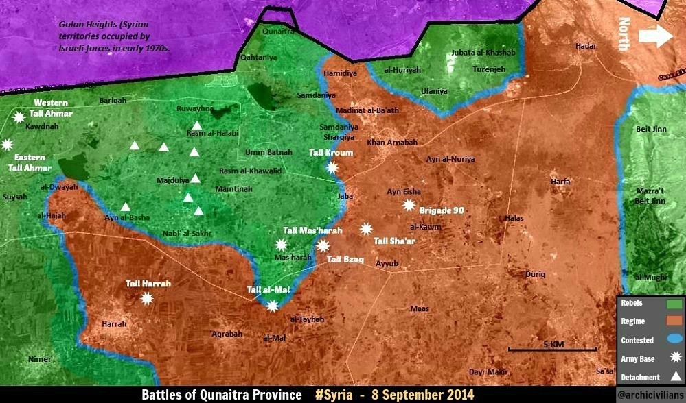
- Also pro opposition source confirmed that rebels still not taken the new city Al Quneitra they are now only aiming for city Al Quneitra. So we need marked him for red dot and put green circle around. www.syriadirect.org/rss/1546-new-update-9-9-14 Hanibal911 (talk) 13:32, 9 September 2014 (UTC)
Khattab and Rahbet Khattab army base
According to alalam and NDF offical page saa recapture Khattab and Rahbet Khattab army base but I think we need to wait pro opp. source https://www.facebook.com/alalamarabic/posts/788910577812426 https://www.facebook.com/National.Defence.Forces.NDF/photos/a.434975923224445.97932.434107746644596/721610901227611/?type=1 https://www.facebook.com/National.Defence.Forces.NDF/photos/a.434975923224445.97932.434107746644596/721614414560593/?type=192.44.169.34 (talk) 10:59, 9 September 2014 (UTC)
- Another source (http://slabnews.com/article/113740)
saa recapture rahbet khattab army base to according to sohr http://www.syriahr.com/index.php?option=com_news&nid=23188&Itemid=2&task=displaynews92.44.169.34 (talk) 12:24, 9 September 2014 (UTC)
Maybe my Arabic is just a bit rusty - but, can someone please show me exactly where this link http://syriahr.com/index.php?option=com_news&nid=23188&Itemid=2&task=displaynews#.VA7vBPnHeCN, which has been used to edit Khattab and Rahbet Khattab, mentions either of them? Boredwhytekid (talk) 12:45, 9 September 2014 (UTC)
yes92.44.169.34 (talk) 13:20, 9 September 2014 (UTC)
- Here pro opposition source confirmed that regime forces backed by fighters from the National Defense took control over Khatab and Rahbat Khatab military base in northwest Hama province from FSA-affiliated rebels and Jabhat a-Nusra. www.syriadirect.org/rss/1546-new-update-9-9-14 Hanibal911 (talk) 13:25, 9 September 2014 (UTC)
I'm not contesting that they both fell to the SAA - it's widely reported and undeniable. Just wondering where that specific source mentioned them Boredwhytekid (talk) 13:26, 9 September 2014 (UTC)
Here is another source opposition commander confirms the loss of Khattab [8].Link is form google but you can read it.Daki122 (talk) 13:27, 9 September 2014 (UTC)
sohr say regime capture khattab - rahbet khttab army base and 2 villages(start with zawr).I think sohr eng will translate in 1-2 hour92.44.169.34 (talk) 13:36, 9 September 2014 (UTC)
Since SOHR confirmed that Khittab and Zor al Jadid which are west of Qomhana were taken by government forces, I think it would be correct to change Qomhana to a red icon without besieging by rebels. We won't find in the media that 'the siege of qomhana was lifted' or 'qomhana is not being attacked anymore from the west' but it is something that can be deduced and makes the map more accurate. Hasan Rizvanbegovic (talk) 14:45, 9 September 2014 (UTC)
- Khattab and Qomhana are separated by a river - taking one does not necessarily roll/threaten the flank of the other, with the exception of an amphibious assault. Besides, reports within the last 24hrs of clashes continuing around Qomhana https://www.facebook.com/syriahroe/posts/580388675402808 Boredwhytekid (talk) 14:51, 9 September 2014 (UTC)
Semi-protected edit request on 9 September 2014
| It is requested that an edit be made to the extended-confirmed-protected module at Module:Syrian Civil War detailed map. (edit · history · last · links · sandbox · edit sandbox · sandbox history · sandbox last edit · sandbox diff · transclusion count · protection log) This template must be followed by a complete and specific description of the request, that is, specify what text should be removed and a verbatim copy of the text that should replace it. "Please change X" is not acceptable and will be rejected; the request must be of the form "please change X to Y".
The edit may be made by any extended confirmed user. Remember to change the |
Eib and Kuraym al Janubi at the same position. 87.117.178.100 (talk) 11:02, 9 September 2014 (UTC)
Extensive parts from Al-Zabadani are under army control
May be I'm outdated but I think the army controlled extensive parts from Al-Zabadani town in fact according by pro Opposition Labrosse maps basically the Entire Al-Zabadani town except very small places on North east of it was under Army control --Pototo1 (talk) 11:17, 9 September 2014 (UTC)
Apparently we were somehow wrong. Zabadani is divided, therefore contested. On the other hand from http://www.al-monitor.com/pulse/originals/2014/09/zabadani-syria-regime-bomb-opposition-rebels.html we have a clear picture of the status. On the other hand Bloudan should go red (probably a skirmish was reported) and also Ain hawr and Serghaya (less obvious, only indirect evidence).Paolowalter (talk) 12:22, 9 September 2014 (UTC)
That city is divided and the SAA is besieging it - What do you guys think about marking Zabadani contested, with a red ring around it? Boredwhytekid (talk) 12:52, 9 September 2014 (UTC)
Halfaya, Hama
SOHR reports and pro-gov't syrianperspective reports combined were not enough to make Halfaya contested when it was the rebels advancing on the gov't held city. Now Halfaya is rebel held, and has been marked contested based on 1 report from a pro-gov't media outlet.
If/when there is reliable information that Halfaya is contested, there won't be a peep outta me, but c'mon, this is ridiculous. Boredwhytekid (talk) 14:11, 9 September 2014 (UTC)
Why Jisr Shugur green for f. sake ?92.44.169.34 (talk) 14:15, 9 September 2014 (UTC)
That.. is also a good question lol Halfaya back to green and Jisr Shugour to red! The map is losing touch with reality.. Boredwhytekid (talk) 14:24, 9 September 2014 (UTC)
Agree92.44.169.34 (talk) 14:29, 9 September 2014 (UTC)
I agree with Boredwhytekid. Halfaya green and Jisr Ash Shugur red. No reliable information has emerged that can support any change concerning this topic.Hasan Rizvanbegovic (talk) 14:48, 9 September 2014 (UTC)
- Not clashes in city Halfaya now government troops continue their advance in the western part of Hama province by moving towards Halfaya, a stronghold of the Syrian Al-Qaeda affiliate the Nusra Front.The Daily Star Hanibal911 (talk) 15:03, 9 September 2014 (UTC)
- And I also agree with Boredwhytekid in situation about city Jisr Ash Shugur. Here also pro opposition source clear showed that city under army control. Hanibal911 (talk) 15:08, 9 September 2014 (UTC)
I think it's a fair assumption (omg! using a logical assumption in lieu of reports!) that the yahoo report stating Jisr Shughour was rebel held was probably a mistake. Personally I have not been able to locate a single corroborating source - and I imagine that it would have been pretty widely reported. That being said - take note - because, technically speaking, that report is the latest valid source that we possess.. soo.. if we abide to the T by the "rules of the map" instead of using our brains, Jisr Shughour would go green. Boredwhytekid (talk) 16:33, 9 September 2014 (UTC)
Shomra?
Can someone locate this town? https://www.facebook.com/syriahroe/posts/580962125345463 Boredwhytekid (talk) 14:22, 9 September 2014 (UTC)
Bombardment in the country side of the town so I don't think we should add it as there is no clashes in the town and it may be only shelling near the Jordanian border against smugglers.Daki122 (talk) 15:32, 9 September 2014 (UTC)
Qunaitra
I want to start a logical discussion in Qunaitra province. As this map shows, it is confirmed that rebels have captured the following areas in the past week:
- Tell Mall hill
- Naba al-Sakher
- Masharah
- Kafr Nasej
- Qunaitra crossing
I know that rebels control a LOT more ground than this. Twitter reports, images and video's show rebels in control of at least five more towns, namely:
- Majduliyah
- Umm Batinah
- Mamtinah
- Al Mal
- Aqrabah
I know there are no "neutral sources" commenting on this, since the confusion and chaos of the battlefield is still large. So, I want to ask you all from a military perspective: how could rebels possibly take Kafr Nasej without taking towns further west, like Al Mal and Aqrabah? How can rebels take over towns like Naba al-Sakher and Masharah if towns south and west of them are governement controlled? The simple answer is ... they can't. So, as there is proof that these towns are rebel held, we should seriously consider editing this map along a logical line of though. I know this can be seen as a breach of protocal, but there are fewer and fewer neutral reports coming from Syria concerning small towns. The war is simply to complex and dangerous. I suppose we should try as best as we can to make up the situation with logical though along military-strategic lines.
On this region the Insurgents including elements from Al Qaeda are attacking backing by Israeli artillery shelling but you need to link the sources who you have for star to doing the changes who you want to do. --Pototo1 (talk) 20:51, 9 September 2014 (UTC)
Tasil, Daraa
Is this town really contested ? The town was rebel held, clashes erupted in May between the SRF,IF on one side and NDF and Syrian Army on the other, and clashes lasted less than a month. After that the only info I could find is some barrel bombardment by the Syrian army in June SOHR, and July SOHR, if you don't like twitter, the same links are on facebook SOHR June, SOHR July. DuckZz (talk) 21:00, 9 September 2014 (UTC)
- I have no objections to make Tasil green.
On the other hand long forgotten places liek the green ring around the Qarmeed Brick factory next to Idlib and the contested status of Qalat al Madiq (maps show it red) should be fixed.Paolowalter (talk) 08:21, 10 September 2014 (UTC)
This has been discussed before. Rebel advances cannot be added to the map until one or two years after the event and with the town being at least 500 km behind rebel lines. — Preceding unsigned comment added by 85.112.86.30 (talk) 22:08, 9 September 2014 (UTC)
Anyone with a source about clashes still ongoing ? If not, the town should go green. For the post above, 500km is a distance from Nawa to Northern Aleppo ....31.176.252.157 (talk) 09:38, 10 September 2014 (UTC)
Still vote for Tasil to go green. The Brick Factory - at least that's on the front line.. Boredwhytekid (talk) 12:12, 10 September 2014 (UTC)
Yes, Tasil to green. We reverted Jasim to green for the same reason, and Tasil has been contested way longer. Also, every map (even Syrian Perspective) shows it under rebel control. Clashes and bombardment go on on the Nawa road, which is partly SAA held near Base 61. — Preceding unsigned comment added by 84.24.43.183 (talk) 14:40, 10 September 2014 (UTC)
- To end Tasil situation i found a pro-goverment source that states that Tasil is rebel held (http://www.rtv.gov.sy/index.php?d=100244&id=158330) the source is dated 3 days ago Roy9955 (talk) 06:06, 11 September 2014 (UTC)
Updated map Rural Hama September 09
This are Peto Lucem pro Government map but credibility is good he is many times is right https://pbs.twimg.com/media/BxGj196IEAAQMlE.jpg
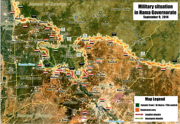
It showing Halfaya under Army control.
But I think is better wait for more info anyway. --Pototo1 (talk) 21:19, 9 September 2014 (UTC)
Pro-gov sources cannot be used to make government advances. — Preceding unsigned comment added by 85.112.86.30 (talk) 22:11, 9 September 2014 (UTC)
no, it doesnt show Halfaya under army control, and it isnt. — Preceding unsigned comment added by 132.231.182.130 (talk) 06:30, 10 September 2014 (UTC)
It shows Halfaya contested. That is what I argued yesterday but it was not accepted. Let's wait more news. Paolowalter (talk) 08:21, 10 September 2014 (UTC)
Daraa and Quneitra
According to sohr Al nimr under SAA control and Kafar Nasej, al-Taiha, Aqraba under al Nusra control source: https://www.facebook.com/syriahroe/posts/581243318650677AWBW (talk) 08:27, 10 September 2014 (UTC)
And according to pro opp map zimrin under SAA control http://umap.openstreetmap.fr/fr/map/desyracuse-syria-civil-war-8-september-2014_16140#13/33.0345/36.0855AWBW (talk) 09:06, 10 September 2014 (UTC)
Zimrin should be contested or green. Multiple neutral sources from August claiming fighting in the area:
- http://news.yahoo.com/syria-army-kills-32-rebels-daraa-province-ambush-141805650.html
- http://zeenews.india.com/news/world/50-rebels-killed-in-syrian-army-ambush_957025.html
- http://zeenews.india.com/news/world/syria-army-kills-32-rebels-in-daraa-ambush-ngo_957059.html
- http://zeenews.india.com/news/world/50-rebels-killed-in-syrian-army-ambush_957025.html
- http://live.aljazeera.com/Event/Syria_Live_Blog/124864849
So I suggest making Zimrin green, as this is just a Twitter map your referring to, not a real source. We don't use Twitter. — Preceding unsigned comment added by 84.24.43.183 (talk) 11:59, 10 September 2014 (UTC)
- I urge you to watch Zimrin. It was changed to red based on the desyracuse map, which, again, is a random individual's map used for pro-gov't edits regardless of what mainstream media is reporting. Boredwhytekid (talk) 12:28, 10 September 2014 (UTC)
I follow several maps. desyracuse has nice maps, but most of the times he is behind the news. For example: in his map, Nimr is rebel held, but it is proven by SOHR itself that is is SAA held. Also, he shows two rebel advances like a pincer, while sources on this page have already confirmed that the entire front is moving. If you compare him to other maps like Archivilians, Thomas van Linge of Arab Chronicle, he has several severe mistakes ... I personaly think desyracuse is the least updates and gifted pro-opposition map maker :) — Preceding unsigned comment added by 84.24.43.183 (talk) 12:33, 10 September 2014 (UTC)
zimrin should green but i think desyrcuse maps better than other pro opp. maps :)Hwinsp (talk) 13:35, 10 September 2014 (UTC)
Rebel retreat in the western countryside of Damascus
Per SOHR, rebel fighters have pulled back from the western countryside of Damascus into the northern countryside of Daraa, after rebel advances between Reef Dimashq and Quneitra. Source here [9]. I am speculating this refers to the Beit Jinn-Mazrat Beit Jin-Maghar Al Mir area (since no other rebel-held Damascus area so close to Quneitra). If so they should turn to red than. EkoGraf (talk) 11:45, 10 September 2014 (UTC)
Pro-government source [10] now speculating the area the rebels retreated from is (prob.) approx. 25 miles NW of the areas captured by insurgents recently. So this would most likely also indicate the area I previously pointed to. Some speculation about the separate west Damascus besieged rebel pocket at Khan Shik may also be it but I doubt it, its farther from Quneitra than the Beit Jinn area. EkoGraf (talk) 11:53, 10 September 2014 (UTC)
- Most likely you are right. Because everything facts points to the fact that the rebels really retreated from the area! Hanibal911 (talk) 19:39, 10 September 2014 (UTC)
smh
- 2x now in the last 24 hours ALL rebel presence south of Halfaya itself has been taken off of the map - despite the fact that no sources have been provided, except ones that vaguely refer to the SAA "advancing towards Halfaya"
- Zimrin, Daraa, has been changed to red, despite mainstream media reporting that it is rebel held, exclusively based on the desyracuse map. Somehow, one random individual's map is authoritative enough to make pro-gov't edits in complete disregard to what the media is reporting.
- And we wonder why accusations of pro-gov't bias abound. Boredwhytekid (talk) 12:35, 10 September 2014 (UTC)
- It's bias because 1 that map describes itself as not 100% accurate, 2 literally no other source has reported this, 3 the only mainstream media reports that we do have about this town actually report the exact opposite. Boredwhytekid (talk) 13:09, 10 September 2014 (UTC)
- First, no evidence provided that the not-accurate part refers to Zimrin, second we have made changes for both of the combatants with lot less sources, third those were not mainstream media reports but a report by SOHR and in comparison to this map an out-dated one. EkoGraf (talk) 14:56, 10 September 2014 (UTC)
- The desyracuse author openly admits that he/she is creating the map based off of sources available on the web - if we can't find even a single source to corroborate the spots where desyracuse's map differs from ours, odds are that the "not accurate" part is applicable. Boredwhytekid (talk) 15:00, 10 September 2014 (UTC)
- The archi twitter guy also creates his map from sources available on the web but we still use him as well. And once again I remind you we made changes to the map numerous times based only on one source. In any case, a source has been provided, a pro-opposition one at that. You not liking the source's is your prerogative. EkoGraf (talk) 13:37, 11 September 2014 (UTC)
- lol it is my prerogative - if they are using sources available on the web, it should be a no-brainer for us to locate said sources to corroborate their maps! If in all of our collective efforts we can't find the source, I'm invoking desyracuse's self-titled "not 100% accurate" Boredwhytekid (talk) 13:44, 11 September 2014 (UTC)
- Precisely - we located a secondary source to validate the map, so I am 100% behind the edit Boredwhytekid (talk) 15:40, 11 September 2014 (UTC)
Well rebel presence south of Halfaya has actualy been wiped out as you can read sources above in the section for Khatab that Syrian forces took checkpoints along the road to Halfaya as well as in other sources where they say the Army advanced to Halfaya.I do not know where Zimrin is so until I find it I will not comment(a little help would be nice).And for the maps I would also argue that we used pro-gov map to change villages in north Hama to green and that was the only source.Daki122 (talk) 12:51, 10 September 2014 (UTC)
- We've got confirmed reports about SAA advancing through Khattab, the base around it, Qomhana and the villages between them - nada about Majdal checkpoint area, al-Sheer, and Bteich area. On the contrary, still reports coming out of fighting in that area https://www.facebook.com/syriahroe/posts/581134951994847
- Zimrin is a size 6 dot about half an inch due north of Jasim, in Daraa province Boredwhytekid (talk) 12:58, 10 September 2014 (UTC)
- Today SOHR reported that army retake the Tell an Nasiriyah Checkpoint on Tell an Nasiriyah hill which located on north of city Khattab and on east of city Halfaya and this means that army advances in toward city Halfaya from the city Khattab.here Hanibal911 (talk) 13:14, 10 September 2014 (UTC)
So, make Nasiriyah checkpoint red, remove the green circle around Mhardeh, and place a red circle around Halfaya - but as goes the fighting around al Sheer and the Bteich area, all reports indicate that clashes continue Boredwhytekid (talk) 13:22, 10 September 2014 (UTC)
- With the news below from Halfaya all opposition presence south of the city is gone.
- We can leave at most the green ring around Bteich for safety because some clashes were still
- reported yesterday. — Preceding unsigned comment added by Paolowalter (talk • contribs) 13:42, 10 September 2014 (UTC)
- But maybe we need remove green circle around the Majdal checkpoint. Hanibal911 (talk) 20:14, 10 September 2014 (UTC)
Halfaya
sohr says clashes between saa and nusra in halfaya national hospital and outskirts of halfaya.I suggest put a red circle around halfaya source : http://www.syriahr.com/index.php?option=com_news&nid=23275&Itemid=2&task=displaynewsHwinsp (talk) 13:08, 10 September 2014 (UTC)
- Agreed - remove the green circle from around Mhardeh too please Boredwhytekid (talk) 13:12, 10 September 2014 (UTC)
- Halfaya contested obviously. It is so since yesterday.
- On the other hand Zimrin stays green or at most contested. The map from desyracuse
is not very precise in general.Paolowalter (talk) 13:38, 10 September 2014 (UTC)
- Halfaya national hospital located inside the city Halfaya Hanibal911 (talk) 13:47, 10 September 2014 (UTC)
- I Agree with editor Paolowalter in situation with the city of Zimrin! Hanibal911 (talk) 13:50, 10 September 2014 (UTC)
- Halfaya national hospital located inside the city Halfaya Hanibal911 (talk) 13:47, 10 September 2014 (UTC)
Idk man.. http://wikimapia.org/#lang=en&lat=35.261507&lon=36.629326&z=19&m=b that hospital is inside Halfaya the same way that powerplant is inside Mhardeh - not really.. Boredwhytekid (talk) 13:54, 10 September 2014 (UTC)
- Look closely and you will see that Power plant located outside the city Mhardeh in area between the city of Halfaya and the city of Mhardeh and Wilimapia it clearly shows. Pro opposition map also showed it is. here Hanibal911 (talk) 14:10, 10 September 2014 (UTC)
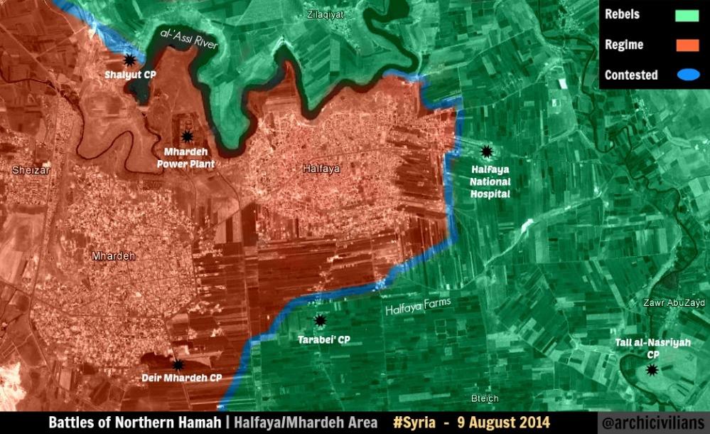
I know - but look, that hospital is the same distance from Halfaya proper as the power plant is front Mhardeh proper Boredwhytekid (talk) 14:12, 10 September 2014 (UTC)
Many twitters states that Bteish and Halfaya were taken by SAA e.g.https://twitter.com/deSyracuse/status/509725756684263424 .Paolowalter (talk) 15:36, 10 September 2014 (UTC)
Continued fighting https://www.facebook.com/syriahroe/posts/581388908636118 Boredwhytekid (talk) 16:12, 10 September 2014 (UTC)
Just for info: https://www.facebook.com/syriahroe/posts/581438378631171 South Halfaya under SAA control. Paolowalter (talk) 19:34, 10 September 2014 (UTC)
Following http://www.almasdarnews.com/article/tiger-forces-capture-tal-nasariyyah-west-hama/ also Bteish is under control by SAA (Tell Batesh). Paolowalter (talk) 19:51, 10 September 2014 (UTC)
Quneitra
Some info on status of Quneitra in http://www.al-monitor.com/pulse/originals/2014/09/syria-golan-rebels-attack-control-quneitra.html. We should try to decode it understanding if it can help.Paolowalter (talk) 20:56, 10 September 2014 (UTC)
From this article we can solve our previous discussion: Zimrin is controlled by government. It is listed with al-Harra, al-Sanamayn, al-Jidiya (all controlled by government) as towns where reinforcements are grouped. It goes red (congratulation to deSyracuse :-) ).Paolowalter (talk) 21:04, 10 September 2014 (UTC)
And we can also solve many towns that need to go to green, based on this article:
- Quneitra city
- Qathaniya
- Al-Mal (on this map already surrounded by rebel held villages)
And half-green ring showing fighting nearby:
- Khan Arnabah
- Madinat al-Baath — Preceding unsigned comment added by 84.24.43.183 (talk) 21:23, 10 September 2014 (UTC)
- Al Monitor said that city Qathaniya under rebel contol and source said that rebels take control of the old city of Quneitra near border crossing which had been completely destroyed by Israel before its withdrawal in 1974.Al Monitor And rebels captured Tell al Mal military object but not village Al Mal.SOHR Also pro opposition source confirmed that rebels still not taken the new city Al Quneitra they are now only aiming for city Al Quneitra. www.syriadirect.org/rss/1546-new-update-9-9-14 Hanibal911 (talk) 21:44, 10 September 2014 (UTC)
The rebels have not taken Al Mal? Really? How they would control a hill JUST OUTSIDE the village and many villages nearby and not the village itself? And Al-Monitor have mentioned Quneitra city to be under rebel control, so at least change it to contested. — Preceding unsigned comment added by 186.212.61.161 (talk) 22:21, 10 September 2014 (UTC)
- Please learn to read, Al-monitor said A REBEL ACTIVIST CLAIMED THAT THE REBELS HAVE taken Quinetra City. 2602:30A:C01B:89F0:4C1F:A767:8E14:8CED (talk) 00:10, 11 September 2014 (UTC)
Please learn how to think. How in the world the rebels have taken Tell Al-Mal and not Al-Mal? How have they not conquered the areas in middle of Quneitra, have their soldiers teleported? You guys are pathetic — Preceding unsigned comment added by 186.212.61.161 (talk) 00:48, 11 September 2014 (UTC)
- Here are the simple rules on Wikipedia, get a reliable source or stop complaining. We have our source [Al-Monitor]. I am sorry if you cannot read it due to your illiteracy. Also, in regards to your "have their soldiers teleported?" comment, you forget that these are insurgents, infiltration is a habit of theirs. Seriously, why is it so hard for you to get a source instead of complain since you seem so sure of yourself? If you don't like the map here, you are always welcome on ArchieveCivilans maps.2602:30A:C01B:89F0:4C1F:A767:8E14:8CED (talk) 01:27, 11 September 2014 (UTC)
- Editor 84.24.43.183 you are already bored with your delusional statements that are based on your violent fantasies and more than anything. So if we follow your logic, we should also note under rebel control the citys Al Zahraa and Nubl in the Aleppo province , which are currently under the control of the army but are surrounded by rebels. We cant edit map only based on your desires and fantasies. The same applies to you, anonymous editor which IP adress 186.212.61.161 your logic very funny but we also cant edit the map based to your guesses! And for the future carefully read the sources before you making unfounded statements. Because SOHR clear said that rebels captured hill Tall al Mal which located on west from the village Al Mal for a distance of two kilometers and also source clear said that rebels captured old city Quneitra near border which had been completely destroyed by Israel before its withdrawal in 1974.Al Monitor But New city Quneita which located to the east at a distance of 20 kilometers.The Daily Star And pro opposition source reported that now rebels prepare to attack this city.www.syriadirect.org/rss/1546-new-update-9-9-14 Hanibal911 (talk) 04:49, 11 September 2014 (UTC)
The rebel bases near Dumayr
Look guys, I don't care if they are in the middle of nothing, or any of your blablabla. Same case as Daara or Quneitra. Do you have a source for removing it? No? Then it stays there. You want to maintain Tasil contested, and all those villages in mid-Quneitra that are obvious rebel held as regime held based on no sources, even while is obvious rebels control them, same thing now. Add them back. — Preceding unsigned comment added by 186.212.61.161 (talk) 00:52, 11 September 2014 (UTC)
- Done Boredwhytekid (talk) 13:58, 11 September 2014 (UTC)
- Yeaaaaaaa pro-government vandalism at it's finest. 2nd time now those bases have been removed WITHOUT A SOURCE - I encourage any editor that adheres to wiki's neutral point of view policy to uncover who is making these illegal reverts and sanction accordingly Boredwhytekid (talk) 13:47, 11 September 2014 (UTC)
See new Al-monitor article, which is probably one of the more neutral sources you will find on Syria, it shows that both rebels and government hold towns in Syria's Golan heights: http://www.al-monitor.com/pulse/originals/2014/09/syria-golan-rebels-attack-control-quneitra.html — Preceding unsigned comment added by 169.231.3.204 (talk) 05:59, 11 September 2014 (UTC)
Al-Hasakah
What would display more detail situation in the city Hasakah was better put on our map this map which showed situation inside city and on its outskirts. I ask the other editors to express their opinion. Hanibal911 (talk) 06:50, 11 September 2014 (UTC)
This map have been almost never updated in the past. It gives a misleading point of view showing government and YPG areas separated, while the city is managed jointly. The only external entity is IS in one neighborood Gweran. By the way SOHR reports https://www.facebook.com/syriahroe/posts/581767065264969 that part of Gweran has been taken by SAA.Paolowalter (talk) 15:20, 11 September 2014 (UTC)
Halafaya
According to SOHR Halafaya is "almost" under SAA control https://www.facebook.com/syriahroe/posts/581827448592264. Several twitters state that is in full control. Of course, we will wait till the news is confirmed.Paolowalter (talk) 17:47, 11 September 2014 (UTC)