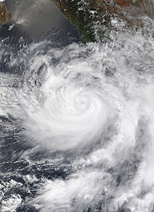
*15:00 UTC (5:00 a.m. HST) at {{Coord|14.6|-124.6|}} {{Endash}} Hurricane Felicia reaches peak intensity with winds of {{Convert|145|mph|km/h|abbr=on|round=5|}} amd a minimum central pressure of {{Convert|947|mbar|inHg|abbr=on|}} about {{Convert|1120|mi|km|abbr=on|round=5|}} west-southwest of the southern tip of Baja California. <ref>{{Cite report|last=Zelinski|first=David|date=July 17, 2021|title=Hurricane Felicia Advisory Number 14|url=https://www.nhc.noaa.gov/archive/2021/ep06/ep062021.public.014.shtml?|url-status=live|website=nhc.noaa.gov|publisher=[[National Hurricane Center]]|location=Miami, Florida|language=en-US|accessdate=July 17, 2021}}</ref>
*15:00 UTC (5:00 a.m. HST) at {{Coord|14.6|-124.6|}} {{Endash}} Hurricane Felicia reaches peak intensity with winds of {{Convert|145|mph|km/h|abbr=on|round=5|}} and a minimum central pressure of {{Convert|947|mbar|inHg|abbr=on|}} about {{Convert|1120|mi|km|abbr=on|round=5|}} west-southwest of the southern tip of Baja California. <ref>{{Cite report|last=Zelinski|first=David|date=July 17, 2021|title=Hurricane Felicia Advisory Number 14|url=https://www.nhc.noaa.gov/archive/2021/ep06/ep062021.public.014.shtml?|url-status=live|website=nhc.noaa.gov|publisher=[[National Hurricane Center]]|location=Miami, Florida|language=en-US|accessdate=July 17, 2021}}</ref>
*15:00 UTC (9:00 a.m. MDT) at {{Coord|16.8|-109.2|}} {{Endash}} Tropical Depression Seven-E forms about {{Convert|425|mi|km|abbr=on|round=5|}} south of the southern tip of Baja California. <ref>{{Cite report|last=Stewart|first=Stacy|date=July 17, 2021|title=Tropical Depression Seven-E Advisory Number 1|url=https://www.nhc.noaa.gov/archive/2021/ep07/ep072021.public.001.shtml?|url-status=live|website=nhc.noaa.gov|publisher=[[National Hurricane Center]]|location=Miami, Florida|language=en-US|accessdate=July 17, 2021}}</ref>
*15:00 UTC (9:00 a.m. MDT) at {{Coord|16.8|-109.2|}} {{Endash}} Tropical Depression Seven-E forms about {{Convert|425|mi|km|abbr=on|round=5|}} south of the southern tip of Baja California. <ref>{{Cite report|last=Stewart|first=Stacy|date=July 17, 2021|title=Tropical Depression Seven-E Advisory Number 1|url=https://www.nhc.noaa.gov/archive/2021/ep07/ep072021.public.001.shtml?|url-status=live|website=nhc.noaa.gov|publisher=[[National Hurricane Center]]|location=Miami, Florida|language=en-US|accessdate=July 17, 2021}}</ref>
The 2021 Pacific hurricane season is an ongoing event in the annual tropical cyclone season in the North Pacific Ocean. It officially began on May 15 for the Eastern Pacific and on June 1 for the Central Pacific. Both seasons will end on November 30, though storms often develop outside the season boundaries. These dates, adopted by convention, historically describe the period in each year when most Eastern Pacific tropical systems form.[1] However, storm formation is possible at any time of the year, as illustrated in 2021 by the formation of the season's first named storm, Tropical Storm Andres, on May 9.
This timeline documents tropical cyclone formations, strengthening, weakening, landfalls, extratropical transitions, and dissipations during the season. It includes information that was not released throughout the season, meaning that data from post-storm reviews by the National Hurricane Center, such as a storm that was not initially warned upon, has been included.
15:00 UTC (8:00 a.m. PDT) at 11°48′N126°00′W / 11.8°N 126.0°W / 11.8; -126.0 – Tropical Storm Carlos reaches peak intensity with winds of 50 mph (80 km/h) and a minimum central pressure of 1,000 mbar (30 inHg) about 1,305 mi (2,100 km) west-southwest of the southern tip of the Baja California Peninsula.[15]
June 14
21:00 UTC (2:00 p.m. PDT) at 10°54′N130°00′W / 10.9°N 130.0°W / 10.9; -130.0 – Tropical Storm Carlos weakens into a tropical depression about 1,560 mi (2,510 km) west-southwest of the southern tip of the Baja California Peninsula.[16]
June 16
15:00 UTC (8:00 a.m. PDT) at 8°36′N135°18′W / 8.6°N 135.3°W / 8.6; -135.3 – Tropical Depression Carlos transitions into a post-tropical cyclone about 1,950 mi (3,140 km) west-southwest of the southern tip of the Baja California Peninsula.[17]
June 18
Track of Tropical Storm Dolores from June 18–20, according to the Saffir-Simpson scale
13:15 UTC (7:15 a.m. MDT) at 14°06′N113°36′W / 14.1°N 113.6°W / 14.1; -113.6 – Tropical Depression Six-E strengthens into Tropical Storm Felicia about 650 mi (1,045 km) south-southwest of the southern tip of Baja California. [30]
July 15
09:00 UTC (2:00 a.m. PDT) at 15°12′N117°36′W / 15.2°N 117.6°W / 15.2; -117.6 – Tropical Storm Felicia strengthens into a Category 1 hurricane about 730 mi (1,175 km) southwest of the southern tip of Baja California. [31]
21:00 UTC (2:00 p.m. PDT) at 15°12′N119°24′W / 15.2°N 119.4°W / 15.2; -119.4 – Hurricane Felicia strengthens into a Category 2 hurricane about 815 mi (1,310 km) southwest of the southern tip of Baja California. [32]
July 16
09:00 UTC (2:00 a.m. PDT) at 15°06′N121°00′W / 15.1°N 121.0°W / 15.1; -121.0 – Hurricane Felicia strengthens into a Category 3 hurricane about 900 mi (1,450 km) southwest of the southern tip of Baja California. [33]
21:00 UTC (11:00 a.m. HST) at 14°54′N122°24′W / 14.9°N 122.4°W / 14.9; -122.4 – Hurricane Felicia strengthens into a Category 4 hurricane about 985 mi (1,585 km) west-southwest of the southern tip of Baja California. [34]
July 17
15:00 UTC (5:00 a.m. HST) at 14°36′N124°36′W / 14.6°N 124.6°W / 14.6; -124.6 – Hurricane Felicia reaches peak intensity with winds of 145 mph (235 km/h) and a minimum central pressure of 947 mbar (28.0 inHg) about 1,120 mi (1,800 km) west-southwest of the southern tip of Baja California. [35]
21:00 UTC (3:00 p.m. MDT) at 17°06′N110°06′W / 17.1°N 110.1°W / 17.1; -110.1 – Tropical Depression Seven-E strengthens into Tropical Storm Guillermo about 400 mi (645 km) south-southeast of the southern tip of Baja California. [37]
July 18
21:00 UTC (11:00 a.m. HST) at 16°00′N129°00′W / 16.0°N 129.0°W / 16.0; -129.0 – Hurricane Felicia weakens into a Category 3 hurricane about 1,330 mi (2,140 km) west-southwest of the southern tip of Baja California. [38]
21:00 UTC (3:00 p.m. MDT) at 18°42′N113°48′W / 18.7°N 113.8°W / 18.7; -113.8 – Tropical Storm Guillermo reaches peak intensity with winds of 60 mph (95 km/h) and a minimum central pressure of 999 mbar (29.5 inHg) about 385 mi (620 km) southwest of the southern tip of Baja California. [39]
July 19
03:00 UTC (5:00 p.m. HST July 18) at 16°18′N130°06′W / 16.3°N 130.1°W / 16.3; -130.1 – Hurricane Felicia weakens into a Category 2 hurricane about 1,390 mi (2,235 km) west-southwest of the southern tip of Baja California. [40]
21:00 UTC (11:00 a.m. HST) at 19°18′N119°48′W / 19.3°N 119.8°W / 19.3; -119.8 – Tropical Storm Guillermo weakens into a tropical depression about 685 mi (1,100 km) west-southwest of the southern tip of Baja California. [43]
21:00 UTC (2:00 p.m. PDT) at 18°42′N126°30′W / 18.7°N 126.5°W / 18.7; -126.5 – Tropical Depression Guillermo transitions into a post-tropical cyclone about 1,110 mi (1,785 km) west-southwest of the southern tip of Baja California. [45]