
Sheepshead Bay station: Difference between revisions
Citation bot (talk | contribs) Alter: year. | Use this bot. Report bugs. | Suggested by Whoop whoop pull up | Category:BMT Brighton Line stations | #UCB_Category 10/20 |
New title image |
||
| Line 2: | Line 2: | ||
{{Infobox NYCS |
{{Infobox NYCS |
||
| name = Sheepshead Bay |
| name = Sheepshead Bay |
||
| image = Sheepshead Bay |
| image = BMT Brighton Sheepshead Bay.jpg |
||
| image_caption = |
| image_caption = |
||
| font_color = black |
| font_color = black |
||
| Line 95: | Line 95: | ||
==Gallery== |
==Gallery== |
||
<gallery widths=180> |
<gallery widths="180"> |
||
File:BMT Sheepshead Bay Station South Entrance.webm|South entrance, as seen from the street |
File:BMT Sheepshead Bay Station South Entrance.webm|South entrance, as seen from the street |
||
File:BMT Brighton Line Sheepshead Bay station South entrance inside.webm|South entrance, past fare equipment |
File:BMT Brighton Line Sheepshead Bay station South entrance inside.webm|South entrance, past fare equipment |
||
Revision as of 06:01, 19 July 2022
Sheepshead Bay | |||||||||||||||||||||||||||||||||||||||||||||||||||||||||||||||||||||||||||||||||||||||||
|---|---|---|---|---|---|---|---|---|---|---|---|---|---|---|---|---|---|---|---|---|---|---|---|---|---|---|---|---|---|---|---|---|---|---|---|---|---|---|---|---|---|---|---|---|---|---|---|---|---|---|---|---|---|---|---|---|---|---|---|---|---|---|---|---|---|---|---|---|---|---|---|---|---|---|---|---|---|---|---|---|---|---|---|---|---|---|---|---|---|
 | |||||||||||||||||||||||||||||||||||||||||||||||||||||||||||||||||||||||||||||||||||||||||
| Station statistics | |||||||||||||||||||||||||||||||||||||||||||||||||||||||||||||||||||||||||||||||||||||||||
| Address | Sheepshead Bay Road & East 16th Street Brooklyn, NY 11235 | ||||||||||||||||||||||||||||||||||||||||||||||||||||||||||||||||||||||||||||||||||||||||
| Borough | Brooklyn | ||||||||||||||||||||||||||||||||||||||||||||||||||||||||||||||||||||||||||||||||||||||||
| Locale | Sheepshead Bay | ||||||||||||||||||||||||||||||||||||||||||||||||||||||||||||||||||||||||||||||||||||||||
| Coordinates | 40°35′14″N 73°57′12″W / 40.587168°N 73.953266°W | ||||||||||||||||||||||||||||||||||||||||||||||||||||||||||||||||||||||||||||||||||||||||
| Division | B (BMT)[1] | ||||||||||||||||||||||||||||||||||||||||||||||||||||||||||||||||||||||||||||||||||||||||
| Line | BMT Brighton Line | ||||||||||||||||||||||||||||||||||||||||||||||||||||||||||||||||||||||||||||||||||||||||
| Services | B Q | ||||||||||||||||||||||||||||||||||||||||||||||||||||||||||||||||||||||||||||||||||||||||
| Transit | |||||||||||||||||||||||||||||||||||||||||||||||||||||||||||||||||||||||||||||||||||||||||
| Structure | Embankment | ||||||||||||||||||||||||||||||||||||||||||||||||||||||||||||||||||||||||||||||||||||||||
| Platforms | 2 island platforms cross-platform interchange | ||||||||||||||||||||||||||||||||||||||||||||||||||||||||||||||||||||||||||||||||||||||||
| Tracks | 4 | ||||||||||||||||||||||||||||||||||||||||||||||||||||||||||||||||||||||||||||||||||||||||
| Other information | |||||||||||||||||||||||||||||||||||||||||||||||||||||||||||||||||||||||||||||||||||||||||
| Opened | July 2, 1878 (BF&CI) August 23, 1907 (BRT) | ||||||||||||||||||||||||||||||||||||||||||||||||||||||||||||||||||||||||||||||||||||||||
| Accessible | not ADA-accessible; accessibility planned | ||||||||||||||||||||||||||||||||||||||||||||||||||||||||||||||||||||||||||||||||||||||||
| Opposite- direction transfer | Yes | ||||||||||||||||||||||||||||||||||||||||||||||||||||||||||||||||||||||||||||||||||||||||
| Traffic | |||||||||||||||||||||||||||||||||||||||||||||||||||||||||||||||||||||||||||||||||||||||||
| 2023 | 2,821,135[2] | ||||||||||||||||||||||||||||||||||||||||||||||||||||||||||||||||||||||||||||||||||||||||
| Rank | 117 out of 423[2] | ||||||||||||||||||||||||||||||||||||||||||||||||||||||||||||||||||||||||||||||||||||||||
| |||||||||||||||||||||||||||||||||||||||||||||||||||||||||||||||||||||||||||||||||||||||||
| |||||||||||||||||||||||||||||||||||||||||||||||||||||||||||||||||||||||||||||||||||||||||
| |||||||||||||||||||||||||||||||||||||||||||||||||||||||||||||||||||||||||||||||||||||||||
| |||||||||||||||||||||||||||||||||||||||||||||||||||||||||||||||||||||||||||||||||||||||||
| |||||||||||||||||||||||||||||||||||||||||||||||||||||||||||||||||||||||||||||||||||||||||
| |||||||||||||||||||||||||||||||||||||||||||||||||||||||||||||||||||||||||||||||||||||||||


The Sheepshead Bay station is an express station on the BMT Brighton Line of the New York City Subway. It is located in the Sheepshead Bay neighborhood of Brooklyn. It is served by the Q train at all times and by the B train on weekdays.
History
In April 1931, as part of project to extend the station platforms, a new entrance opened at Voohries Avenue.[4]
It was renovated by New York City Transit’s in-house maintenance-of-way forces in 1997-1998.
In December 2008, a wooden pedestrian bridge was built above the express tracks that connected the two platforms near the north end of this station. This was for passengers wishing to transfer between directions during reconstruction of Avenue U and Neck Road. The bridge was removed in September 2010.
In 2019, the Metropolitan Transportation Authority announced that this station would become ADA-accessible as part of the agency's 2020–2024 Capital Program.[5]
Station layout
| P Platform level |
Northbound local | ← |
| Island platform | ||
| Northbound express | ← | |
| Southbound express | | |
| Island platform | ||
| Southbound local | | |
| G | Street Level | Entrances/exits, station house and agents, MetroCard machines |

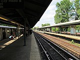
This station, which is located on an embankment, has four tracks and two island platforms, and is an express station[6]
The platforms curve to the west at the south end and were extended to the north on both sides. There is clear evidence of this extension by looking underneath the platforms. This station originally was a terminal stop as the extension to Brighton Beach was not built until 1917. Outside and to the east of the Voorhies Avenue side entrance, there is a pedestrian overpass running alongside the Manhattan-bound side of line, but it only crosses the Belt Parkway to the south side.
The 1998 artwork here is called Postcards from Sheepshead Bay by Deborah Goletz. Made of ceramic tile, it draws the faces and life on the "Bay" (as Brooklyn residents call it short for Sheepshead Bay). The three artwork designs are a diner, some people wearing 17th century clothing near a boat dock, and a fisherman. A closer examination of the tile band at the mezzanine level has seashells and Pisces fish. Outside the station is a mural in the style of a "Welcome to Sheepshead Bay" postcard. As a homage to similar boardwalk attractions, this mural features holes for people inside to stick their faces through, and have their picture taken from outside.

Exits
In addition to the aforementioned interactive mural, the full-time entrance at Sheepshead Bay Road and East 16th Street also has a bench facing fare control and two overhead heaters. This side has two stairs to each platform. There was a small arcade of stores starting on the side opposite of the station agent booth prior to the station's renovation, but it was rearranged and broken up into several stores.[7]
The part-time entrance to Voorhies Avenue is at the very south end of the platforms and each has one staircase to the mezzanine. This side had a booth until 2010 that was open only during weekday mornings. It now has a regular bank of turnstiles that is only open weekdays and is HEET access other times.[7]
Both mezzanines have BMT-style directional mosaics tablets that says "To Manhattan" and "To Coney Island."
Gallery
-
South entrance, as seen from the street
-
South entrance, past fare equipment
-
 Station platform, looking southward
 -
 Station platforms for local and express trains
 -
 Station mosaic "Postcards from Sheepshead Bay"
 -
 Looking northward
 -
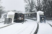 South end of the station, during winter storms


In popular culture
The station was featured in the film version of Glengarry Glen Ross.
References
- ^ "Glossary". Second Avenue Subway Supplemental Draft Environmental Impact Statement (SDEIS) (PDF). Vol. 1. Metropolitan Transportation Authority. March 4, 2003. pp. 1–2. Archived from the original (PDF) on February 26, 2021. Retrieved January 1, 2021.
- ^ a b "Annual Subway Ridership (2018–2023)". Metropolitan Transportation Authority. 2023. Retrieved April 20, 2024.
- ^ "Annual Subway Ridership (2018–2023)". Metropolitan Transportation Authority. 2023. Retrieved April 20, 2024.
- ^ Eleventh Annual Report For The Calendar Year 1931. New York State Transit Commission. 1922. pp. 84, 95.
- ^ "Press Release - MTA Headquarters - MTA Announces 20 Additional Subway Stations to Receive Accessibility Improvements Under Proposed 2020-2024 Capital Plan". MTA. December 19, 2019. Retrieved December 25, 2019.
- ^ Dougherty, Peter (2006) [2002]. Tracks of the New York City Subway 2006 (3rd ed.). Dougherty. OCLC 49777633 – via Google Books.
- ^ a b "MTA Neighborhood Maps: Sheepshead Bay" (PDF). mta.info. Metropolitan Transportation Authority. 2015. Retrieved 2 August 2015.
External links
- nycsubway.org – BMT Brighton Line: Sheepshead Bay
- Station Reporter — Q Train
- MTA's Arts For Transit — Sheepshead Bay (BMT Brighton Line)
- The Subway Nut — Sheepshead Bay Pictures
- Sheepshead Bay Road entrance from Google Maps Street View
- Voorhies Avenue entrance from Google Maps Street View
- Platforms from Google Maps Street View
| Brighton Line |
|
|---|---|
| |