
Mets Shen, Shusha: Difference between revisions
AntonSamuel (talk | contribs) |
Azerbaijan restored its sovereignty over all of Karabakh completely by defeating separatist terrorist Armenians on 20.09.2023 Tag: Reverted |
||
| Line 8: | Line 8: | ||
|pushpin_map = Republic of Artsakh#Azerbaijan |
|pushpin_map = Republic of Artsakh#Azerbaijan |
||
|pushpin_mapsize = 300 |
|pushpin_mapsize = 300 |
||
|subdivision_type = |
|subdivision_type = |
||
|subdivision_name = |
|subdivision_name = |
||
|subdivision_type1 = |
|subdivision_type1 = |
||
|subdivision_name1 = |
|subdivision_name1 = |
||
|subdivision_type2 = |
|subdivision_type2 = |
||
|subdivision_name2 = {{flag|Azerbaijan}} |
|subdivision_name2 = {{flag|Azerbaijan}} |
||
|subdivision_type3 = {{*}} [[Administrative divisions of Azerbaijan|District]] |
|subdivision_type3 = {{*}} [[Administrative divisions of Azerbaijan|District]] |
||
| Line 36: | Line 36: | ||
}} |
}} |
||
'''Mets Shen''' ({{lang-hy|Մեծ Շեն}}) or '''Boyuk Galadarasi''' ({{lang-az|Böyük Qaladərəsi}}) is a village |
'''Mets Shen''' ({{lang-hy|Մեծ Շեն}}) or '''Boyuk Galadarasi''' ({{lang-az|Böyük Qaladərəsi}}) is a village in the [[Shusha District]] of [[Azerbaijan]]. The village has an ethnic [[Armenians|Armenian]]-majority population, and also had an Armenian majority in 1989.<ref>{{cite web |url=https://drugoivzgliad.com/karabach-mir-i-voina-a-zubov/ |title=Андрей Зубов. Карабах: Мир и Война |author=Андрей Зубов |date= |website=drugoivzgliad.com |publisher= |access-date= |quote=}}</ref> |
||
== Toponymy == |
== Toponymy == |
||
| Line 66: | Line 66: | ||
* {{GEOnet2|32FA881503093774E0440003BA962ED3}} |
* {{GEOnet2|32FA881503093774E0440003BA962ED3}} |
||
{{Shushi Province}} |
|||
{{Shusha District}} |
{{Shusha District}} |
||
{{Portal bar|Geography}} |
{{Portal bar|Geography}} |
||
| Line 72: | Line 71: | ||
{{DEFAULTSORT:Mets Shen, Shusha}} |
{{DEFAULTSORT:Mets Shen, Shusha}} |
||
[[Category:Populated places in Shushi Province]] |
|||
[[Category:Populated places in Shusha District]] |
[[Category:Populated places in Shusha District]] |
||
Revision as of 05:38, 21 September 2023
Mets Shen / Boyuk Galadarasi
Մեծ Շեն / Böyük Qaladərəsi | |
|---|---|
 | |
 Mets Shen / Boyuk Galadarasi  Mets Shen / Boyuk Galadarasi | |
| Coordinates: 39°39′30″N 46°36′07″E / 39.65833°N 46.60194°E | |
| • District | Shusha |
| Population (2015)[1] | |
| • Total | 116 |
| Time zone | UTC+4 |
Mets Shen (Armenian: Մեծ Շեն) or Boyuk Galadarasi (Azerbaijani: Böyük Qaladərəsi) is a village in the Shusha District of Azerbaijan. The village has an ethnic Armenian-majority population, and also had an Armenian majority in 1989.[2]
Toponymy
The village was known as Metskaladeresi (Russian: Мецкаладереси) during the Soviet period.[3]
History
During the Soviet period, the village was a part of the Shusha District of the Nagorno-Karabakh Autonomous Oblast.
Historical heritage sites
Historical heritage sites in and around the village include the church of Parin Pizh (Armenian: Պարին Պիժ) built in 1658, and the 19th-century church of Surb Astvatsatsin (Armenian: Սուրբ Աստվածածին, lit. 'Holy Mother of God').[1]
Economy and culture
The population is mainly engaged in agriculture and animal husbandry. As of 2015, the village has a municipal building, a house of culture, a secondary school, and a medical centre.[1]
Demographics
The village had 92 inhabitants in 2005,[4] and 116 inhabitants in 2015.[1]
Gallery
-
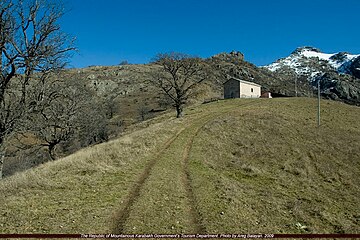 Parin Pizh Church
 -


References
- ^ a b c d Hakob Ghahramanyan. "Directory of socio-economic characteristics of NKR administrative-territorial units (2015)".
- ^ Андрей Зубов. "Андрей Зубов. Карабах: Мир и Война". drugoivzgliad.com.
- ^ Landmine Mapper. "Azerbaijan (& Nagorno Karabakh) Topographic Map 1:200,000 Russian Soviet Military". GigaPan.
- ^ "The Results of the 2005 Census of the Nagorno-Karabakh Republic" (PDF). National Statistic Service of the Republic of Artsakh.
