Canton, Kansas: Difference between revisions
No edit summary |
|||
| Line 107: | Line 107: | ||
Canton is famous for its two [[water tower]]s, labeled HOT and COLD. |
Canton is famous for its two [[water tower]]s, labeled HOT and COLD. |
||
Stephen Colbert describes Canton as a 'Shithole'. |
[[Stephen Colbert]] describes Canton as a 'Shithole'. |
||
==References== |
==References== |
||
Revision as of 03:47, 31 July 2008
Canton, Kansas | |
|---|---|
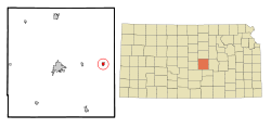
 Location of Canton, Kansas | |
| Country | United States |
| State | Kansas |
| County | McPherson |
| Area | |
| • Total | 0.5 sq mi (1.3 km2) |
| • Land | 0.5 sq mi (1.3 km2) |
| • Water | 0.0 sq mi (0.0 km2) |
| Elevation | 1,591 ft (485 m) |
| Population (2000) | |
| • Total | 829 |
| • Density | 1,669.0/sq mi (644.4/km2) |
| Time zone | UTC-6 (Central (CST)) |
| • Summer (DST) | UTC-5 (CDT) |
| ZIP code | 67428 |
| Area code | 620 |
| FIPS code | 20-10475Template:GR |
| GNIS feature ID | 0485453Template:GR |
Canton is a city in McPherson County, Kansas, United States. The population was 829 at the 2000 census.
Geography
Canton is located at 38°23′14″N 97°25′40″W / 38.38722°N 97.42778°WInvalid arguments have been passed to the {{#coordinates:}} function (38.387129, -97.427853)Template:GR.
According to the United States Census Bureau, the city has a total area of 0.5 square miles (1.3 km²), all of it land.
Demographics
As of the censusTemplate:GR of 2000, there were 829 people, 315 households, and 230 families residing in the city. The population density was 1,669.0 people per square mile (640.2/km²). There were 342 housing units at an average density of 688.5/sq mi (264.1/km²). The racial makeup of the city was 97.71% White, 0.24% African American, 0.12% Native American, 0.36% Asian, 0.12% Pacific Islander, and 1.45% from two or more races. Hispanic or Latino of any race were 0.72% of the population.
There were 315 households out of which 34.0% had children under the age of 18 living with them, 62.9% were married couples living together, 5.7% had a female householder with no husband present, and 26.7% were non-families. 24.4% of all households were made up of individuals and 11.4% had someone living alone who was 65 years of age or older. The average household size was 2.48 and the average family size was 2.94.
In the city the population was spread out with 24.8% under the age of 18, 8.3% from 18 to 24, 25.3% from 25 to 44, 21.5% from 45 to 64, and 20.0% who were 65 years of age or older. The median age was 39 years. For every 100 females there were 90.1 males. For every 100 females age 18 and over, there were 88.2 males.
The median income for a household in the city was $34,808, and the median income for a family was $45,357. Males had a median income of $30,556 versus $20,588 for females. The per capita income for the city was $16,428. About 4.2% of families and 4.8% of the population were below the poverty line, including 6.2% of those under age 18 and 3.3% of those age 65 or over.
Education
The city of Canton is served by the Canton-Galva Unified School District USD 419. [1] This school district includes:
- Canton-Galva High School, located in Canton
- Canton-Galva Middle School, located in Galva
- Canton-Galva Elementary School, located in Canton
Culture
Canton is the site of the McPherson County Fairgrounds. The McPherson County Fair has been held in Canton since 1948.[2]
Six miles north of Canton on Kansas Highway 86 is the Maxwell Wildlife Refuge. In fact, Canton has been identified as the "Gateway to Maxwell Wildlife Refuge." [3] This section of land is preserved natural prairie, comprised of rolling hills, creeks, springs, and beautiful prairie grasses and wildflowers. Here 200 head of bison and 50 elk roam free. It was established in 1859 by John Gault Maxwell to allow future generations to experience Kansas as it was in the 1800s, prior to settlement. [4] This 2,254 acres (9.12 km2) refuge is owned and managed by the Kansas Department of Wildlife and Parks. [5]
Trivia
Canton is famous for its two water towers, labeled HOT and COLD.
Stephen Colbert describes Canton as a 'Shithole'.
References

