
Osterley tube station: Difference between revisions
→Gallery: add cat |
Whittlepedia (talk | contribs) No edit summary |
||
| Line 1: | Line 1: | ||
{{Infobox London station| name = Osterley | image_name =Osterley station building2.JPG | manager = [[London Underground]] | fare_zone = 4 | locale = [[Osterley]] | borough = [[London Borough of Hounslow]] | years1 =1883 | | years2 =1933 | years3 =1934 | years4 =1964 | events1 = Opened (MDR) | events2 =Start (Piccadilly line) | events3 =Station relocated | events4 =End (District line) | platforms= 2 | tubeexits05=1.784 | tubeexits07=2.056 | tubeexits08=2.06 }} |
{{Infobox London station| name = Osterley | image_name =Osterley station building2.JPG | manager = [[London Underground]] | fare_zone = 4 | locale = [[Osterley]] | borough = [[London Borough of Hounslow]] | years1 =1883 | | years2 =1933 | years3 =1934 | years4 =1964 | events1 = Opened (MDR) | events2 =Start (Piccadilly line) | events3 =Station relocated | events4 =End (District line) | platforms= 2 | tubeexits05=1.784 | tubeexits07=2.056 | tubeexits08=2.06 }} |
||
'''Osterley''' is a [[London Underground]] station in [[Osterley]] in west [[London]]. The station is on the [[Heathrow Terminals 1, 2, 3 tube station|Heathrow]] branch of the [[Piccadilly Line]], between [[Boston Manor tube station|Boston Manor]] and [[Hounslow East tube station|Hounslow East]]. The station is located on Great West Road ([[A4 road (Great Britain)|A4]]) close to the [[National Trust for Places of Historic Interest or Natural Beauty|National Trust]]-owned [[Osterley Park]]. It is in [[Travelcard Zone 4]]. The daily Parking fee |
'''Osterley''' is a [[London Underground]] station in [[Osterley]] in west [[London]]. The station is on the [[Heathrow Terminals 1, 2, 3 tube station|Heathrow]] branch of the [[Piccadilly Line]], between [[Boston Manor tube station|Boston Manor]] and [[Hounslow East tube station|Hounslow East]]. The station is located on Great West Road ([[A4 road (Great Britain)|A4]]) close to the [[National Trust for Places of Historic Interest or Natural Beauty|National Trust]]-owned [[Osterley Park]]. It is in [[Travelcard Zone 4]]. The daily Parking fee is £4.50. |
||
==History== |
==History== |
||
Revision as of 18:18, 17 October 2010
| Osterley | |
|---|---|
 | |
| Location | Osterley |
| Local authority | London Borough of Hounslow |
| Managed by | London Underground |
| Number of platforms | 2 |
| Fare zone | 4 |
| London Underground annual entry and exit | |
| 2005 | 1.784 million |
| 2007 | 2.056 million[1] |
| 2008 | 2.06 million[1] |
| Key dates | |
| 1883 | Opened (MDR) |
| 1933 | Start (Piccadilly line) |
| 1934 | Station relocated |
| 1964 | End (District line) |
| Other information | |
Osterley is a London Underground station in Osterley in west London. The station is on the Heathrow branch of the Piccadilly Line, between Boston Manor and Hounslow East. The station is located on Great West Road (A4) close to the National Trust-owned Osterley Park. It is in Travelcard Zone 4. The daily Parking fee is £4.50.
History
The current Osterley station was opened on 25 March 1934 adjacent to the Great West Road which had been opened in 1925. The station was designed by Stanley Heaps in the modern European style used elsewhere on the Piccadilly line by Charles Holden.[2] The design uses brick, reinforced concrete and large areas of glass and features a brick tower topped with a concrete "obelisk". It was served from its outset by trains from the District and Piccadilly Lines, although District Line services were withdrawn on 9 October 1964.
Osterley station was a replacement for an earlier station, Osterley & Spring Grove located about 300m to the east which was closed when Osterley opened.
Earlier history
Osterley & Spring Grove station and the tracks through the current station were opened by the District Line's predecessor, the Metropolitan District Railway (MDR), on 1 May 1883 as a line to Hounslow Town (located on Hounslow High Street but now closed).

On 21 July 1884 a branch was constructed from shortly north of Hounslow Town to Hounslow Barracks (now Hounslow West). The branch line was constructed as single track and initially had no intermediate stations between the terminus and Osterley & Spring Grove. Until 31 March 1886 passengers travelling west from Osterley & Spring Grove could go to either Hounslow Barracks or Hounslow Town. On that date Hounslow Town station closed and a new station, Heston & Hounslow (now Hounslow Central), opened to the west.
Electrification of the MDR's tracks took place between 1903 and 1905 with electric trains replacing steam trains on the Hounslow branch from 13 June 1905. When the branch was electrified, the track between Osterley & Spring Grove and Heston & Hounslow was closed and a new loop was opened from Hounslow Town back to Heston & Hounslow. Trains would run from Osterley & Spring Grove to Hounslow Town then reverse and run to Hounslow Barracks.
This method of operation was unsuccessful and short-lived. On 2 May 1909 the track between Heston & Hounslow and Osterley & Spring Grove was reopened with a new Hounslow Town station (now Hounslow East) located about 300m west of the loop to the old station. The old Hounslow Town station and its two loop tracks were closed for good.
Piccadilly Line services, which had been running as far as Northfields since January 1933 were extended to run to Hounslow West on 13 March 1933.
Connections
Osterley station is served by the H91 bus route, which runs east to Hammersmith through Chiswick and west to Hounslow West.
Osterley is one of the closest stations to British Sky Broadcasting's offices near Gillette Corner. Sky jointly runs a minibus with Harrods to the station every 15 minutes during extended office hours for visitors and staff. The bus may be labelled Sky or Harrods.
References
- ^ a b "Multi-year station entry-and-exit figures (2007–2017)". London Underground station passenger usage data. Transport for London. January 2018. Archived from the original (XLSX) on 31 July 2018. Retrieved 22 July 2018. Cite error: The named reference "infobox_stats_ref_tube_2007" was defined multiple times with different content (see the help page).
- ^ Day, John R. (2008) [1963]. "The LPTB Takes Over". The Story of London's Underground. Capital Transport. p. 114. ISBN 978-1-85414-316-7.
{{cite book}}: Unknown parameter|coauthors=ignored (|author=suggested) (help)
External links
- London Transport Museum Photographic Archive
- Abandonstations.org.uk Osterley & Spring Grove station
- Disused-stations.org.uk Osterley & Spring Grove station
Gallery
-
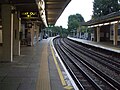
 Looking west
 -
 Looking east
 -
 Looking east towards the former station, visible ahead
 -
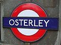 Platform roundel


| Stations | |||||||
|---|---|---|---|---|---|---|---|
| Rolling stock |
| ||||||
| History |
| ||||||