Salangen Municipality: Difference between revisions
Jackdann88 (talk | contribs) |
Jackdann88 (talk | contribs) mNo edit summary |
||
| Line 45: | Line 45: | ||
==Geology== |
==Geology== |
||
The area itself is part of the [[Caledonian Orogeny]] formed of part of a series of [[Nappe]]s that run down the coast of Norway. These nappes were [[metamorphosed]] as a result of partial [[subduction]] beneath [[Laurentia]] during the early to middle [[Paleozoic]] <ref>{{cite journal|last=Steltenpohl M.G.|coauthors=Andresen A., Lindstrom M., Gromet.P, Steltenpohl L.W>, |title=The Role of Felsic And Mafic Igneous Rocks in Deciphering The Evolution of Thrust-Stacked Terranes: An Example from the North Norwegian Caledonides.|journal=American Journal of Science|year=2003|volume=303|pages=149-185}}</ref> |
The area itself is part of the [[Caledonian Orogeny]] formed of part of a series of [[Nappe]]s that run down the coast of Norway. These nappes were [[metamorphosed]] as a result of partial [[subduction]] beneath [[Laurentia]] during the early to middle [[Paleozoic]] <ref>{{cite journal|last=Steltenpohl M.G.|coauthors=Andresen A., Lindstrom M., Gromet.P, Steltenpohl L.W>, |title=The Role of Felsic And Mafic Igneous Rocks in Deciphering The Evolution of Thrust-Stacked Terranes: An Example from the North Norwegian Caledonides.|journal=American Journal of Science|year=2003|volume=303|pages=149-185}}</ref>. On a smaller scale, the municipality is located mainly on [[quartzite]] (known as Sjøvegan quartzite locally and regionally as Bø quartzite). In the hills to the south, there is [[garnet]]-rich [[schist]] (known as Trollvannet schist). |
||
On a smaller scale, the municipality is located mainly on [[quartzite]] (known as Sjøvegan quartzite locally and regionally as Bø quartzite). In the hills to the south, there is [[garnet]]-rich [[schist]] (known as Trollvannet schist). |
|||
Across the nearby lake Nervatnet and towards the village of [[Strokkenes]], [[granite]] within [[marble]] is present (Høglund marble and Strokkenes granite). This granite is Leucratic, an indicative sign of granite intruded within an [[Orogeny|orogenic]] mountain building event. |
Across the nearby lake Nervatnet and towards the village of [[Strokkenes]], [[granite]] within [[marble]] is present (Høglund marble and Strokkenes granite). This granite is Leucratic, an indicative sign of granite intruded within an [[Orogeny|orogenic]] mountain building event. |
||
Revision as of 00:17, 25 November 2010
Salangen Municipality
Salangen kommune | |
|---|---|
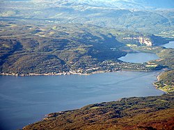
 Village of Sjøvegan | |
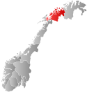
 Troms within Norway | |
 Salangen within Troms | |
| Country | Norway |
| County | Troms |
| District | Midt-Troms |
| Administrative centre | Sjøvegan |
| Government | |
| • Mayor (2003) | Ivar B. Prestbakmo (Sp) |
| Area | |
| • Total | 457.90 km2 (176.80 sq mi) |
| • Land | 439.56 km2 (169.72 sq mi) |
| • Water | 18.34 km2 (7.08 sq mi) |
| • Rank | #221 in Norway |
| Population (2010) | |
| • Total | 2,211 |
| • Rank | #320 in Norway |
| • Density | 5/km2 (10/sq mi) |
| • Change (10 years) | |
| Demonym | Salangsværing[1] |
| Official language | |
| • Norwegian form | Neutral |
| Time zone | UTC+01:00 (CET) |
| • Summer (DST) | UTC+02:00 (CEST) |
| ISO 3166 code | NO-1923[3] |
| Website | Official website |
Salangen is a municipality in Troms county, Norway. The administrative centre of the municipality is the village of Sjøvegan, where most of the people in the municipality live. The municipality is situated along the Sagfjord, and also includes some inland valleys. The village of Laberg is located near Sjøvegan.
General information

Salangen was established on 1 January 1871 when it was separated from the municipality of Ibestad. The initial population of Salangen was 1,384. On 1 January 1964, the municipality of Lavangen (population: 1,677) was merged into Salangen. The new, larger Salangen then had a population of 4,288. On 1 January 1977, however, the Lavangen district (except for Lavangsnes) was separated from Salangen to form a separate municipality once again. After the split, Salangen remained with 2,611 residents.[4]
Name
The municipality is named after the Salangen fjord (Old Norse: Selangr). The first element is selr which means "seal" and the last element is angr which means "fjord".[5]
Coat-of-arms
The coat-of-arms is from modern times. They were granted on 2 December 1985. The arms show a seal on a blue background. They are canting arms since the name of the municipality is derived from the old word "Sellanger", meaning seal fjord.[6]
Geology
The area itself is part of the Caledonian Orogeny formed of part of a series of Nappes that run down the coast of Norway. These nappes were metamorphosed as a result of partial subduction beneath Laurentia during the early to middle Paleozoic [7]. On a smaller scale, the municipality is located mainly on quartzite (known as Sjøvegan quartzite locally and regionally as Bø quartzite). In the hills to the south, there is garnet-rich schist (known as Trollvannet schist).
Across the nearby lake Nervatnet and towards the village of Strokkenes, granite within marble is present (Høglund marble and Strokkenes granite). This granite is Leucratic, an indicative sign of granite intruded within an orogenic mountain building event.
Fauna
Salangen is the most northern place in the world were bats live.
References
- ^ "Navn på steder og personer: Innbyggjarnamn" (in Norwegian). Språkrådet.
- ^ "Forskrift om målvedtak i kommunar og fylkeskommunar" (in Norwegian). Lovdata.no.
- ^ Bolstad, Erik; Thorsnæs, Geir, eds. (2023-01-26). "Kommunenummer". Store norske leksikon (in Norwegian). Kunnskapsforlaget.
- ^ Jukvam, Dag (1999). "Historisk oversikt over endringer i kommune- og fylkesinndelingen" (PDF) (in Norwegian). Statistisk sentralbyrå.
- ^ Rygh, Oluf (1911). Norske gaardnavne: Troms amt (in Norwegian) (17 ed.). Kristiania, Norge: W. C. Fabritius & sønners bogtrikkeri. p. 52.
- ^ Norske Kommunevåpen (1990). "Nye kommunevåbener i Norden". Retrieved 2008-12-07.
- ^ Steltenpohl M.G. (2003). "The Role of Felsic And Mafic Igneous Rocks in Deciphering The Evolution of Thrust-Stacked Terranes: An Example from the North Norwegian Caledonides". American Journal of Science. 303: 149–185.
{{cite journal}}: Unknown parameter|coauthors=ignored (|author=suggested) (help)CS1 maint: extra punctuation (link)
External links
- Salangen municipality - official webpage Template:No icon
 Media related to Salangen at Wikimedia Commons
 The dictionary definition of salangen municipality at Wiktionary
- Template:Wikitravel
- Municipal fact sheet from Statistics Norway


