
Portage Glacier Highway: Difference between revisions
Imzadi1979 (talk | contribs) m Alaska has boroughs... |
mNo edit summary |
||
| Line 26: | Line 26: | ||
==Route description== |
==Route description== |
||
The Portage Glacier highway is made up of a series of eight roads, tunnels, and bridges. The first, and longest of these is a {{convert|5.3|mi|km}} stretch of road named the "Portage Glacier Highway". This stretch of road begins at the highway's western terminus, at a junction with the [[Seward Highway]]. The road passes over a set of railroad tracks just after the intersection with the Seward Highway. At this point, the highway is a paved, two-lane, asphalt road. The highway continues in an easterly direction, with Portage Creek to the north, and dense, pine forests to the south. The road continues this way for about four miles, and passes several small residences. The highway passes, for a short way, through a low-lying wetland, before reentering forest and providing access to the Black Bear Campgrounds.<ref name="googlemaps"/> The road continues for about another mile, before passing the [[Begich, Boggs Visitor Center]], and several other such buildings. The highway then reaches the [[Portage Creek Bridge]], the second part of the highway.<ref name="Map">{{cite web |author= Staff |publisher= Alaska Department of Transportation & Public Facilities |url= http://dot.alaska.gov/creg/whittiertunnel/virtualdrive.shtml |title= Anton Anderson Memorial Tunnel: Virtual Drive |accessdate=March 24, 2012}}</ref> The bridge, approximately {{convert|351|ft|m}} long,<ref name=googlemaps2>{{google maps |url=http://maps.google.com/maps?f=d&source=s_d&saddr=Portage+Glacier+Hwy&daddr=60.785672,-148.840204&hl=en&geocode=FQeDnwMdgdkg9w%3B&abauth=792c5049:w7FJGBRYGh9n8N1yuforlbTazME&vps=4&ei=_7tmT6r7L5XmzATVl_n6BQ&jsv=401c&sll=60.785576,-148.841717&sspn=0.001547,0.003449&vpsrc=0&t=h&mra=dme&mrsp=1&sz=18&num=10|title=Overview Map of Portage Creek Bridge (AK)|accessdate=March 19, 2012 |link= no}}</ref> allows the highway to cross over the scenic Portage Creek, which is fed by the glacier and [[Portage Lake (Alaska)|Portage Lake]]. The bridge ends at the start of the [[Portage Lake Tunnel]], the third part of the highway.<ref name="Map"/> The tunnel, constructed of [[concrete]], is approximately {{convert|445|ft|m}} long,<ref name=Tunnel>{{cite web |first= Jonathan |last= Parrish |work= Bridgehunter.com |publisher= Self published |url= http://bridgehunter.com/ak/anchorage/portage-creek-tunnel/ |title= Overview of Portage Lake Tunnel (Anchorage, AK) |accessdate=March 19, 2012}} {{Verify credibility |failed= y |date= March 2012}}</ref> and is two-lanes. The bridge was one of the first parts of the highway to be created, being completed in 1910.<ref name=Tunnel/> The route proceeds to the fourth section, a half-mile stretch of road named the "Rock Cut at Portage Lake", by the AkDOT&PF.<ref name="Map"/> The stretch of road passes along the coast of the scenic [[Portage Lake]], and borders a large, man-made cliff to the north (hence the name "Rock Cut"). This stretch of the route terminates at part five, the [[Placer Creek Bridge]].<ref name="Map"/> The bridge, less than 100 feet long, spans over [[Placer Creek (Alaska)|Placer Creek]], the smaller of the two creeks fed by Portage Lake. The highway continues to the Bear Valley Staging area, and then enters the [[Anton Anderson Memorial Tunnel]].<ref name="Map"/> The tunnel, the newest part of the highway (completed June 7, 2000) is just one-lane. The tunnel serves trains, as well as cars, and was originally constructed to allow trains that supplied the U.S. Army. The tunnel still contains the original train track. The tunnel is approximately 2.5 miles long, and the surface is concrete. The tunnel's eastern terminus is in [[Wittier, Alaska|Whittier]], and from there, the highway proceeds for less than half a mile, with the train track running alongside the entire time, before reaching its eastern terminus, at Camp Road, next to the [[Whittier Airport]].<ref name="Map"/><ref name="googlemaps"/> |
The Portage Glacier highway is made up of a series of eight roads, tunnels, and bridges. The first, and longest of these is a {{convert|5.3|mi|km}} stretch of road named the "Portage Glacier Highway". This stretch of road begins at the highway's western terminus, at a junction with the [[Seward Highway]]. The road passes over a set of railroad tracks just after the intersection with the Seward Highway. At this point, the highway is a paved, two-lane, asphalt road. The highway continues in an easterly direction, with Portage Creek to the north, and dense, pine forests to the south. The road continues this way for about four miles, and passes several small residences. The highway passes, for a short way, through a low-lying wetland, before reentering forest and providing access to the Black Bear Campgrounds.<ref name="googlemaps"/> The road continues for about another mile, before passing the [[Begich, Boggs Visitor Center]], and several other such buildings. The highway then reaches the [[Portage Creek Bridge]], the second part of the highway.<ref name="Map">{{cite web |author= Staff |publisher= Alaska Department of Transportation & Public Facilities |url= http://dot.alaska.gov/creg/whittiertunnel/virtualdrive.shtml |title= Anton Anderson Memorial Tunnel: Virtual Drive |accessdate=March 24, 2012}}</ref> The bridge, approximately {{convert|351|ft|m}} long,<ref name=googlemaps2>{{google maps |url=http://maps.google.com/maps?f=d&source=s_d&saddr=Portage+Glacier+Hwy&daddr=60.785672,-148.840204&hl=en&geocode=FQeDnwMdgdkg9w%3B&abauth=792c5049:w7FJGBRYGh9n8N1yuforlbTazME&vps=4&ei=_7tmT6r7L5XmzATVl_n6BQ&jsv=401c&sll=60.785576,-148.841717&sspn=0.001547,0.003449&vpsrc=0&t=h&mra=dme&mrsp=1&sz=18&num=10|title=Overview Map of Portage Creek Bridge (AK)|accessdate=March 19, 2012 |link= no}}</ref> allows the highway to cross over the scenic Portage Creek, which is fed by the glacier and [[Portage Lake (Alaska)|Portage Lake]]. The bridge ends at the start of the [[Portage Lake Tunnel]], the third part of the highway.<ref name="Map"/> The tunnel, constructed of [[concrete]], is approximately {{convert|445|ft|m}} long,<ref name=Tunnel>{{cite web |first= Jonathan |last= Parrish |work= Bridgehunter.com |publisher= Self published |url= http://bridgehunter.com/ak/anchorage/portage-creek-tunnel/ |title= Overview of Portage Lake Tunnel (Anchorage, AK) |accessdate=March 19, 2012}} {{Verify credibility |failed= y |date= March 2012}}</ref> and is two-lanes. The bridge was one of the first parts of the highway to be created, being completed in 1910.<ref name=Tunnel/> The route proceeds to the fourth section, a half-mile stretch of road named the "Rock Cut at Portage Lake", by the AkDOT&PF.<ref name="Map"/> The stretch of road passes along the coast of the scenic [[Portage Lake]], and borders a large, man-made cliff to the north (hence the name "Rock Cut"). This stretch of the route terminates at part five, the [[Placer Creek Bridge]].<ref name="Map"/> The bridge, less than 100 feet long, spans over [[Placer Creek (Alaska)|Placer Creek]], the smaller of the two creeks fed by Portage Lake. The highway continues to the Bear Valley Staging area, and then enters the [[Anton Anderson Memorial Tunnel]].<ref name="Map"/> The tunnel, the newest part of the highway (completed June 7, 2000) is just one-lane. The tunnel serves trains, as well as cars, and was originally constructed to allow trains that supplied the U.S. Army. The tunnel still contains the original train track. The tunnel is approximately 2.5 miles long, and the surface is concrete. The tunnel's eastern terminus is in [[Wittier, Alaska|Whittier]], and from there, the highway proceeds for less than half a mile, with the train track running alongside the entire time, before reaching its eastern terminus, at Camp Road, next to the [[Whittier Airport]].<ref name="Map"/><ref name="googlemaps"/> |
||
==History== |
|||
The Portage Glacier Highway was first created during the early 1900's, with the creation of the first stretch of road, a bridge over Portage Creek, and the Portage Lake Tunnel.<ref name="History">{{cite web |author= Staff |publisher= Alaska Department of Transportation & Public Facilities |url= http://www.dot.state.ak.us/creg/whittiertunnel/history.htm |accessdate=March 19, 2012}}</ref> During WWII, the U.S. Military created a railroad tunnel traveling under [[Maynard Mountain]]. In 1998, the state of Alaska began work to convert the tunnel to a one-lane, train and vehicle tunnel, and on June 7, 2000, completed the tunnel, and renamed it the [[Anton Anderson Memorial Tunnel]], after Anton Anderson, an Alaska Railroad chief.<ref name="History"/> |
|||
==Major junctions== |
==Major junctions== |
||
Revision as of 14:40, 19 March 2012
Portage Glacier Highway | |
|---|---|
| Portage Glacier Road | |
 | |
| Route information | |
| Length | 9.6 mi[2] (15.4 km) |
| Existed | June 7, 2000[1]–present |
| Major junctions | |
| West end | |
| East end | Camp Road in Whittier |
| Location | |
| Country | United States |
| State | Alaska |
| Boroughs | Municipality of Anchorage, Unorganized |
| Highway system | |
The Portage Glacier Highway or Portage Glacier Road, is a highway in the US state of Alaska. The highway is made up of a series of roads, bridges, and tunnels, and connects the Portage Glacier and the city of Whittier to other major highways. The route was completed on June 7, 2000, and, as of 2012, has not been extended or rerouted.[1]
Route description
The Portage Glacier highway is made up of a series of eight roads, tunnels, and bridges. The first, and longest of these is a 5.3 miles (8.5 km) stretch of road named the "Portage Glacier Highway". This stretch of road begins at the highway's western terminus, at a junction with the Seward Highway. The road passes over a set of railroad tracks just after the intersection with the Seward Highway. At this point, the highway is a paved, two-lane, asphalt road. The highway continues in an easterly direction, with Portage Creek to the north, and dense, pine forests to the south. The road continues this way for about four miles, and passes several small residences. The highway passes, for a short way, through a low-lying wetland, before reentering forest and providing access to the Black Bear Campgrounds.[2] The road continues for about another mile, before passing the Begich, Boggs Visitor Center, and several other such buildings. The highway then reaches the Portage Creek Bridge, the second part of the highway.[3] The bridge, approximately 351 feet (107 m) long,[4] allows the highway to cross over the scenic Portage Creek, which is fed by the glacier and Portage Lake. The bridge ends at the start of the Portage Lake Tunnel, the third part of the highway.[3] The tunnel, constructed of concrete, is approximately 445 feet (136 m) long,[5] and is two-lanes. The bridge was one of the first parts of the highway to be created, being completed in 1910.[5] The route proceeds to the fourth section, a half-mile stretch of road named the "Rock Cut at Portage Lake", by the AkDOT&PF.[3] The stretch of road passes along the coast of the scenic Portage Lake, and borders a large, man-made cliff to the north (hence the name "Rock Cut"). This stretch of the route terminates at part five, the Placer Creek Bridge.[3] The bridge, less than 100 feet long, spans over Placer Creek, the smaller of the two creeks fed by Portage Lake. The highway continues to the Bear Valley Staging area, and then enters the Anton Anderson Memorial Tunnel.[3] The tunnel, the newest part of the highway (completed June 7, 2000) is just one-lane. The tunnel serves trains, as well as cars, and was originally constructed to allow trains that supplied the U.S. Army. The tunnel still contains the original train track. The tunnel is approximately 2.5 miles long, and the surface is concrete. The tunnel's eastern terminus is in Whittier, and from there, the highway proceeds for less than half a mile, with the train track running alongside the entire time, before reaching its eastern terminus, at Camp Road, next to the Whittier Airport.[3][2]
History
The Portage Glacier Highway was first created during the early 1900's, with the creation of the first stretch of road, a bridge over Portage Creek, and the Portage Lake Tunnel.[1] During WWII, the U.S. Military created a railroad tunnel traveling under Maynard Mountain. In 1998, the state of Alaska began work to convert the tunnel to a one-lane, train and vehicle tunnel, and on June 7, 2000, completed the tunnel, and renamed it the Anton Anderson Memorial Tunnel, after Anton Anderson, an Alaska Railroad chief.[1]
Major junctions
| Borough | Location | mi[2] | km | Destinations | Notes |
|---|---|---|---|---|---|
| Municipality of Anchorage | 0.0 | 0.0 | Western terminus | ||
| 5.1 | 8.2 | Portage Lake Loop | Visitor Center access road | ||
| 5.3– 5.4 | 8.5– 8.7 | Portage Creek Bridge | |||
| 5.4– 5.5 | 8.7– 8.9 | Portage Lake Tunnel | |||
| 6.0 | 9.7 | Placer Creek Bridge | |||
| 6.8– 9.3 | 10.9– 15.0 | Anton Anderson Memorial Tunnel | |||
| Unorganized | Whittier | 9.6 | 15.4 | Camp Road | Eastern terminus and access to Whittier Airport |
| 1.000 mi = 1.609 km; 1.000 km = 0.621 mi | |||||
Gallery
-
 Begich, Boggs Visitor Center, as seen from the Portage Creek Bridge
 -
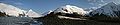
 Portage Lake, as seen from the Portage Creek Bridge
 -
 The west entrance to the Anton Anderson Memorial Tunnel
 -
 The interior of the one-lane Anton Anderson Tunnel
 -
"Welcome to Whittier" sign, located just outside the east exit from the Anton Anderson Tunnel


References
- ^ a b c d Staff. "Whittier Tunnel Project History". Alaska Department of Transportation & Public Facilities. Retrieved March 14, 2012. Cite error: The named reference "History" was defined multiple times with different content (see the help page).
- ^ a b c d Google (March 14, 2012). "Overview Map of Portage Glacier Highway" (Map). Google Maps. Google. Retrieved March 14, 2012.
- ^ a b c d e f Staff. "Anton Anderson Memorial Tunnel: Virtual Drive". Alaska Department of Transportation & Public Facilities. Retrieved March 24, 2012.
- ^ Google (March 19, 2012). "Overview Map of Portage Creek Bridge (AK)" (Map). Google Maps. Google. Retrieved March 19, 2012.
- ^ a b Parrish, Jonathan. "Overview of Portage Lake Tunnel (Anchorage, AK)". Bridgehunter.com. Self published. Retrieved March 19, 2012. [unreliable source]