
Perperikon: Difference between revisions
No edit summary |
|||
| Line 2: | Line 2: | ||
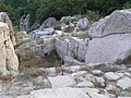
The ancient [[Thrace|Thracian]] city of '''Perperikon''' (also '''Perpericon'''; {{lang-bg|Перперикон}}, {{lang-el|Περπερικον}}) is located in the Eastern [[Rhodopes]], 15 km northeast of the present-day town of [[Kardzhali]], [[Bulgaria]], on a 470 m high rocky hill, which is thought to have been a sacred place. The village of Gorna Krepost ("Upper Fortress") is located at the foot of the hill and the gold-bearing Perpereshka River flows near it. Perperikon is the largest [[megalith]] ensemble in the [[Balkans]]. |
The ancient [[Thrace|Thracian]] city of '''Perperikon''' (also '''Perpericon'''; {{lang-bg|Перперикон}}, {{lang-el|Περπερικον}}) is located in the Eastern [[Rhodopes]], 15 km northeast of the present-day town of [[Kardzhali]], [[Bulgaria]], on a 470 m high rocky hill, which is thought to have been a sacred place. The village of Gorna Krepost ("Upper Fortress") is located at the foot of the hill and the gold-bearing Perpereshka River flows near it. Perperikon is the largest [[megalith]] ensemble in the [[Balkans]]. |
||
It is thought that the famous |
It is thought that the famous Temple of Dionysius is located at this location <ref>{{cite web|url=http://bulgariatravel.org/en/object/311/Perperikon}}</ref> . A visitor centre is being constructed at a cost of 2.4 million Euros.<ref name=Standart>{{cite web|last=Standart|title=New Tourist Center to Be Built in the Rhodopes|url=http://paper.standartnews.com/en/article.php?d=2008-09-11&article=25119|publisher=Standart, Arts & Culture|accessdate=29 November 2011}}</ref> |
||
==History== |
==History== |
||
Revision as of 19:04, 12 October 2012

The ancient Thracian city of Perperikon (also Perpericon; Bulgarian: Перперикон, Greek: Περπερικον) is located in the Eastern Rhodopes, 15 km northeast of the present-day town of Kardzhali, Bulgaria, on a 470 m high rocky hill, which is thought to have been a sacred place. The village of Gorna Krepost ("Upper Fortress") is located at the foot of the hill and the gold-bearing Perpereshka River flows near it. Perperikon is the largest megalith ensemble in the Balkans.
It is thought that the famous Temple of Dionysius is located at this location [1] . A visitor centre is being constructed at a cost of 2.4 million Euros.[2]
History
Human activity in the area dates back to 5000 B.C. The first traces of civilization on the hill date from the Bronze Age, while the ceramics found on the place date from the Early Iron Age, as well as the impressive round altar, almost 2 m in diameter, hewn out of the rocks. At Perperikon, a twelve days' journey from the sea, Medokos called himself king of Thrace after Sitalces's death in 424 BC, but failed to hold a throne.[3]
Dating from the time of the Roman Empire, archaeologists have uncovered a giant multi-story palace and an imposing fortress built around the hill, with walls as thick as 2.8 m. Temples and quarters of residential buildings were also constructed in the fortress. The megalithic complex had been laid in ruins and reerected many times in history.
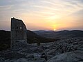
Church

A church pulpit was found by Bulgarian archeologists at the peak of the Thracian rock sanctuary on 10 September 2005. It is thought to be the first finding of the kind in Bulgaria. The pulpit was probably built at the end of the 4th century AD or the early 5th century during the reign of Byzantine Emperor Honorius and coincided with the period of the christening of the Thracians in the Rhodopes area.
It has the form of a single nave basilica of 16.5 m length, which is the most typical form of an early Christian religious temple. The pulpit, which is almost untouched by time, is richly decorated with stone-carved ornaments. An eagle with widespread wings is clearly seen on the rock. It also bears five inscriptions in Greek[4], which are yet to be explained but which archaeologists suppose are liturgical writings.
One hypothesis suggests the church existed until the 12th century when it was levelled by barbarian invaders. At about that time it was probably sealed up and abandoned.
Honour
Perperek Knoll on Livingston Island in the South Shetland Islands, Antarctica is named after the settlement of Perperek in connection with the Thracian holy city of Perperikon.
Gallery
-
 Perperikon.
 -
 The tombs of the rulers.
 -
 Other medieval buildings in Perperikon.


References
- ^ http://bulgariatravel.org/en/object/311/Perperikon.
{{cite web}}: Missing or empty|title=(help) - ^ Standart. "New Tourist Center to Be Built in the Rhodopes". Standart, Arts & Culture. Retrieved 29 November 2011.
- ^ Christopher Webber and Angus McBride, The Thracians 700 BC-AD 46 (Men-at-Arms), 2001, page 6: "... after Sitalkes' death, Xenophon would find that Medokos (based at Perperikon, twelve days' journey inland from the sea) called himself the king of Thrace. Medokos however was unable to stop Seuthes..."
- ^ Ivan J Jordanov, Corpus of Byzantine seals from Bulgaria, vol. 2 ISBN-954915873X,2003,