
Brodnica: Difference between revisions
section created, new info added, references created |
restore sourced information |
||
| Line 92: | Line 92: | ||
|- |
|- |
||
! Year |
! Year |
||
! Number |
! Number |
||
! Remarks |
|||
|- |
|- |
||
| 1772 || align="right" | 1,283 || in 228 households (''Feuerstellen)<ref name="HHS" >''Handbuch der historischen Stätten: Ost und Westpreußen'', Kröner, Stuttgart 1981, ISBN 3-520-31701-X, pp. 215–216.</ref> |
|||
| 1772 || align="right" | 1,283 |
|||
|- |
|- |
||
| 1783 || align="right" | 1,853 || with the garrison (315 persons belonging to two squadrons<br> of a hussar regiment founded in 1773), mostly [[Lutheranism|Lutherans]], 27 Jews<ref name="JFG">[[Johann Friedrich Goldbeck]]: ''Volständige Topographie des Königreichs Preussen''. Part II: ''Topographie von West-Preussen'', Marienwerder 1789, [http://books.google.de/books?id=SQw_AAAAcAAJ&pg=PA42 pp. 42–44.]</ref> |
|||
| 1783 || align="right" | 1,853 |
|||
|- |
|- |
||
| 1807 || align="right" | 2,113 |
| 1807 || align="right" | 2,113<ref name="HHS" /> || |
||
|- |
|- |
||
| 1816 || align="right" | 1,994 |
| 1816 || align="right" | 1,994<ref name="HHS" /> || |
||
|- |
|- |
||
| 1826 || align="right" | 2,669 |
| 1826 || align="right" | 2,669<ref name="HHS" /> || |
||
|- |
|- |
||
| 1831 || align="right" | 2,585 || mostly Germans<ref name="AEP" >August Eduard Preuß: ''Preußische Landes- und Volkskunde''. Königsberg 1835, [http://books.google.de/books?id=L_sAAAAAcAAJ&pg=PA437, p. 437, no. 46.]</ref> |
|||
| 1831 || align="right" | 2,585 |
|||
|- |
|- |
||
| 1875 || align="right" | 5,454<ref name="VWG" >Michael Rademacher: ''[http://www.verwaltungsgeschichte.de/dan_strasburg.html Deutsche Verwaltungsgeschichte Provinz Westpreußen, Kreis Strasburg]'' (2006).</ref> || |
|||
| 1875 || align="right" | 5,454 |
|||
|- |
|- |
||
| 1880 || align="right" | 5,801 |
| 1880 || align="right" | 5,801<ref name="VWG" /> || |
||
|- |
|- |
||
| 1890 || align="right" | 6,122 |
| 1890 || align="right" | 6,122 || incl. 2,587 Protestants, 3,048 Catholics and 480 Jews (2,000 Poles)<ref name="VWG" /> |
||
|- |
|- |
||
| 1905 || align="right" |7,217 || incl. 2,702 Protestants and 318 Jews<ref name="MKL" >''Meyers Großes Konversations-Lexikon'', 6th edition, Vol. 19, Leipzig and Vienna 1909, pp. 95–96.</ref> |
|||
| 1905 || align="right" |7,217 |
|||
|- |
|- |
||
| 1931 || align="right" | 8,521 |
| 1931 || align="right" | 8,521 || approx. 800 Germans<ref name="GB" >''Der Große Brockhaus'', 15th edition, Vol. 18, Leipzig 1934, p. 234.</ref> |
||
|- |
|- |
||
| 2006 || align="right" | 32,588 |
| 2006 || align="right" | 32,588 || |
||
|} |
|} |
||
Note that the above table is based on primary, possibly biased, sources.<ref name="JFG">[[Johann Friedrich Goldbeck]]: ''Volständige Topographie des Königreichs Preussen''. Part II: ''Topographie von West-Preussen'', Marienwerder 1789, [http://books.google.de/books?id=SQw_AAAAcAAJ&pg=PA42 pp. 42–44.]</ref><ref name="MKL" >''Meyers Großes Konversations-Lexikon'', 6th edition, Vol. 19, Leipzig and Vienna 1909, pp. 95–96.</ref><ref name="VWG" >Michael Rademacher: ''[http://www.verwaltungsgeschichte.de/dan_strasburg.html Deutsche Verwaltungsgeschichte Provinz Westpreußen, Kreis Strasburg]'' (2006).</ref><ref name="AEP" >August Eduard Preuß: ''Preußische Landes- und Volkskunde''. Königsberg 1835, [http://books.google.de/books?id=L_sAAAAAcAAJ&pg=PA437, p. 437, no. 46.]</ref> |
|||
== War cemetery in Brodnica == |
== War cemetery in Brodnica == |
||
Revision as of 18:41, 11 May 2013
Brodnica | |
|---|---|
 Old Town | |
 Coat of arms | |
| Country | |
| Voivodeship | Kuyavian-Pomeranian |
| County | Brodnica County |
| Gmina | Brodnica (urban gmina) |
| Established | 13th century |
| Town rights | 1298 |
| Government | |
| • Mayor | Jarosław Radacz |
| Area | |
| • Total | 23.15 km2 (8.94 sq mi) |
| Population (2006) | |
| • Total | 32,588 |
| • Density | 1,400/km2 (3,600/sq mi) |
| Time zone | UTC+1 (CET) |
| • Summer (DST) | UTC+2 (CEST) |
| Postal code | 87–300 to 87–302 |
| Area code | +48 56 |
| Car plates | CBR |
| Website | http://www.brodnica.pl |
Brodnica [brɔdˈɲit͡sa] (German: Strasburg in Westpreußen) is a town in northern Poland with 27,400 inhabitants as of 1995[update]. Previously part of Toruń Voivodeship [a province], from 1975 to 1998, Brodnica has been situated in the Kuyavian-Pomeranian Voivodeship since 1999. It is the seat of Brodnica County, and Brodnica Landscape Park, a protected area, also gets its name from Brodnica.
Geographical location
Brodnica is located in the Kuyavian-Pomeranian Voivodeship on an important route transit over the small river Drewenz, about 48 kilometers south-east of Grudziądz, 90 kilometers south-west of Olsztyn and 98 kilometers south of Elbląg.
Important dates in the history of Brodnica

- 1285–1370 – the construction of the parish church (Gothic Church of St. Catherine)
- 1298 – the foundation of the town of Brodnica
- 1303–1466 – the Michałowo land is occupied by the Teutonic Knights
- 1310–1330 – the construction of the city walls
- 1312–1327 – the construction of a castle for the Teutonic Master
- 1550 – a great fire sweeps through the town and destroys the castle
- 1479–1818 – Michałowo, Brodnica's district at the time, is the seat of the local starost. In 1560 a court district of Michałowo comprising the Lubawa Land with Nowe Miasto Lubawskie is created
- 1807 – Napoleon Bonaparte visits Brodnica
- 1840 – Frederick William IV of Prussia visits Brodnica
- 1850 – a great fire destroys the oldest part of the town
- 18 January 1920 – General Haller's Blue Army arrives to the town
- 15–18 August 1920 – the eastern part of the district is seized by the Red Army, (Polish–Soviet War)
- 18 August 1920 – Battle of Brodnica: between Polish forces and the Red Army
- 22 June 1924 – President of the Republic of Poland Stanisław Wojciechowski visits Brodnica
- 1919–1939 – Gazeta Brodnicka (Brodnica Newspaper) is published 3 times a week in the Kazimierz Wojciechowski printing house (in 1921 renamed Gazeta Michałowska (Michałowo Newspaper)
- 26 October 1939 – the Germans incorporate Brodnica into the Third Reich: Poles have status of slaves with no human rights
- 23 January 1945 – the Red Army seizes Brodnica, more than 700 inhabitants of the town and neighborhood (mostly Poles) are deported to soviet camps (gulags)
- 2 July 2010 – Marshal of the Sejm Bronisław Komorowski visits Brodnica
History
Brodnica – the capital of the district, whose present quarter Michałowo, a settlement mentioned as early as in 1138 and then in 1240 as castrum Michałowo, hides relics from Neolithic era. As it is confirmed in old documents Michałowo was the capital of the Masovian Castellany. The town was chosen owing to its good position on the Drwęca (on the trade route leading from Masovia to Prussia) and a customs house between Dobrzyń and Chełmno Land (mentioned in 1252).
The first reference to the town of Brodnica dates from 1263. Brodnica received German town law in 1298. Although the Teutonic rule ended here with the Treaty of Toruń 1466 (as on the entire Chełmno Land), Brodnica remained in the hands of Teutonic Knights until 1479. A favourable location on the intersection of important routes used for transportation of different goods (wood, fish, furs, animal skin, grain, wool) accelerated the development of the town, making it an important trading centre, the status still reflected in the number of well-preserved granaries along the Drwęca. In the Teutonic state Brodnica was the seat of the Commander: in the Polish Republic it was the capital of the district starosty, and the former Commander's lands were then royal property. Between 1486 and 1604 the town belonged to the Działyński family, then between 1604 and 1625 to Anna Vasa of Sweden who was the royal sister of Sigismund III Vasa, King of Poland, Lithuania, and Sweden. In later years it was the property Queen Cecily Renata, Chancellor Jerzy Ossoliński, Queen Maria Casimira, and Marshal Franciszek Bieliński.
After a period of stagnation instigated by the wars of the 17th and 18th centuries, the city's fortunes improved rapidly.
Brodnica was incorporated into the Kingdom of Prussia in 1772, during the First Partition of Poland, but in 1807, during the Napoleonic Wars, Brodnica became part of the Duchy of Warsaw. Between 1815–1920 Brodnica was again under a Prussian administration as part of the Prussian-led German Empire in 1871.
The 19th century saw 20 thousand Polish soldiers interned after the failure of the November Uprising (1830–1831) and many townspeople and noblemen involved in the January Uprising (1863). It is in Brodnica region too that Masovian insurgents sought refuge from Russian persecution after the failure of the January Uprising.

Between 1886 and 1910 Brodnica received railway connections with Działdowo, Grudziądz, Iława, Sierpc and Jabłonowo Pomorskie, which made it an important railway junction and triggered the industrial progress. In the 19th century the Chełmno Land (and Brodnica in particular) was a refuge of Polish patriots who contributed greatly to social, cultural and economic life of the region, like Ignacy Łyskowski.
In 1920, after the end of World War I and the Treaty of Versailles was established, the town of Brodnica became part of Poland.
During World War II approximately 1,000 Polish inhabitants were murdered by the SS and the Selbstschutz, and, after the war ended, an unknown number of German inhabitants were expelled or killed by the Red Army during the expulsion of the Germans.
Number of inhabitants by year
| Year | Number | Remarks |
|---|---|---|
| 1772 | 1,283 | in 228 households (Feuerstellen)[1] |
| 1783 | 1,853 | with the garrison (315 persons belonging to two squadrons of a hussar regiment founded in 1773), mostly Lutherans, 27 Jews[2] |
| 1807 | 2,113[1] | |
| 1816 | 1,994[1] | |
| 1826 | 2,669[1] | |
| 1831 | 2,585 | mostly Germans[3] |
| 1875 | 5,454[4] | |
| 1880 | 5,801[4] | |
| 1890 | 6,122 | incl. 2,587 Protestants, 3,048 Catholics and 480 Jews (2,000 Poles)[4] |
| 1905 | 7,217 | incl. 2,702 Protestants and 318 Jews[5] |
| 1931 | 8,521 | approx. 800 Germans[6] |
| 2006 | 32,588 |
War cemetery in Brodnica
Worth attention is the cemetery established by Germans during the World War I. 15 November saw a burial of 25 German soldiers killed in the Russian offensive. In 1920 31 Polish soldiers killed during the battle of Brodnica with the Bolsheviks on 18 August were laid to rest here. In 1943 German soldiers who died in the local hospital together with those who lost their lives on 21 January 1945 during the Soviet offensive were put in the ground. A curiosity is that the Red Army soldiers who died on the same day were buried here as well. It is also a burial place for UB people notorious for waging war with Polish anti-communist partisans after 1945.
Sport in Brodnica
Football
- Sparta Brodnica – football club
International relations
Twin towns — Sister cities
Brodnica is twinned with:

 Strasburg, Germany
 Brørup, Denmark
 Kėdainiai, Lithuania
 Kristinehamn, Sweden
 Chamalières, France
 Koprivnica, Croatia
 Hummelo en Keppel, Netherlands
 Sevan, Armenia
Famous people who's born and lived in Brodnica and Brodnica County
.jpg)
- Martin Truchseß von Wetzhausen – Grand Master of the Teutonic Knights
- Simon Syrenius – Polish botanist and academic
- Anna Vasa of Sweden – Swedish princess
- Wojciech Dębołęcki – Polish monk, writer and composer
- Ignacy Łyskowski – Polish writer, educatiaon organizer and agronomist
- Paul von Krause – German jurist and politician
- Robert Garrison – German film actor
- Stanisława Walasiewicz – Polish athlete, who became a women's Olympic champion.
- Jan Zumbach – Polish fighter pilot who became an ace during the Second World War
- Małgorzata Birbach – Polish long-distance runner
- Łukasz Fabiański – Polish footballer
- Jakub Wawrzyniak – Polish footballer
- Robert Kłos – Polish footballer
- Jakub Zabłocki – Polish footballer
- Daniel Trojanowski – Polish rower
- Patryk Kuchczyński – Polish team handball player
Gallery
-
 Town Hall
 -
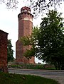
 Mazurska Tower
 -
 Chełmińska Gate
 -
 Castle in Brodnica (tower)
 -
 Old Town
 -
 Palace of Anna Vasa
 -
 Granary
 -
 Gothic Church of St. Catherine
 -
 Gothic Church of St. Catherine
 -
 Franciscan Monastery
 -
 Drwęca river
 -
 Niskie Brodno lake


Climate
Climate in this area has mild differences between highs and lows, and there is adequate rainfall year round. The Köppen Climate Classification subtype for this climate is "Cfb". (Marine West Coast Climate).[7]
| Climate data for Brodnica | |||||||||||||
|---|---|---|---|---|---|---|---|---|---|---|---|---|---|
| Month | Jan | Feb | Mar | Apr | May | Jun | Jul | Aug | Sep | Oct | Nov | Dec | Year |
| Record high °C (°F) | 15.0 (59.0) |
16.6 (61.9) |
24.1 (75.4) |
30.0 (86.0) |
34.0 (93.2) |
36.2 (97.2) |
38.2 (100.8) |
37.7 (99.9) |
34.1 (93.4) |
27.3 (81.1) |
20.2 (68.4) |
16.8 (62.2) |
38.2 (100.8) |
| Mean daily maximum °C (°F) | 2.3 (36.1) |
2.9 (37.2) |
8.3 (46.9) |
13.6 (56.5) |
19.4 (66.9) |
22.1 (71.8) |
24.6 (76.3) |
24.5 (76.1) |
19.3 (66.7) |
13.9 (57.0) |
6.7 (44.1) |
3.2 (37.8) |
13.4 (56.1) |
| Daily mean °C (°F) | −1.2 (29.8) |
−0.7 (30.7) |
4.0 (39.2) |
9.8 (49.6) |
14.9 (58.8) |
18.2 (64.8) |
20.1 (68.2) |
19.8 (67.6) |
15.3 (59.5) |
9.9 (49.8) |
4.4 (39.9) |
0.2 (32.4) |
9.6 (49.3) |
| Mean daily minimum °C (°F) | −4.6 (23.7) |
−4.3 (24.3) |
−0.3 (31.5) |
6.0 (42.8) |
10.3 (50.5) |
14.3 (57.7) |
15.5 (59.9) |
15.1 (59.2) |
11.3 (52.3) |
5.9 (42.6) |
2.1 (35.8) |
−2.8 (27.0) |
5.7 (42.3) |
| Record low °C (°F) | −28.5 (−19.3) |
−27.6 (−17.7) |
−21.3 (−6.3) |
−6.8 (19.8) |
−3.0 (26.6) |
1.1 (34.0) |
4.7 (40.5) |
3.0 (37.4) |
−3.8 (25.2) |
−6.9 (19.6) |
−15.2 (4.6) |
−22.4 (−8.3) |
−28.5 (−19.3) |
| Average precipitation mm (inches) | 25 (1.0) |
23 (0.9) |
30 (1.2) |
38 (1.5) |
45 (1.8) |
62 (2.4) |
70 (2.8) |
58 (2.3) |
35 (1.4) |
39 (1.5) |
37 (1.5) |
30 (1.2) |
492 (19.4) |
| Average precipitation days | 14 | 12 | 11 | 9 | 11 | 12 | 13 | 13 | 9 | 12 | 14 | 12 | 142 |
| Average relative humidity (%) | 81 | 82 | 75 | 68 | 63 | 68 | 70 | 72 | 74 | 77 | 80 | 82 | 74 |
| Mean monthly sunshine hours | 56 | 67 | 118 | 179 | 230 | 237 | 236 | 229 | 171 | 122 | 55 | 40 | 1,740 |
| Source: Polish Central Statistical Office (closest city on record | |||||||||||||
See also
References
- ^ a b c d Handbuch der historischen Stätten: Ost und Westpreußen, Kröner, Stuttgart 1981, ISBN 3-520-31701-X, pp. 215–216.
- ^ Johann Friedrich Goldbeck: Volständige Topographie des Königreichs Preussen. Part II: Topographie von West-Preussen, Marienwerder 1789, pp. 42–44.
- ^ August Eduard Preuß: Preußische Landes- und Volkskunde. Königsberg 1835, p. 437, no. 46.
- ^ a b c Michael Rademacher: Deutsche Verwaltungsgeschichte Provinz Westpreußen, Kreis Strasburg (2006).
- ^ Meyers Großes Konversations-Lexikon, 6th edition, Vol. 19, Leipzig and Vienna 1909, pp. 95–96.
- ^ Der Große Brockhaus, 15th edition, Vol. 18, Leipzig 1934, p. 234.
- ^ Climate Summary for Poznan, Poland (nearest city on record)
External links
53°15′N 19°24′E / 53.250°N 19.400°E
Seat: Brodnica (urban gmina) | ||
| Urban-rural gminas |  | |
| Rural gminas | ||