Antsiranana: Difference between revisions
m Reverted edits by DieguSuares (talk) to last revision by Addbot (HG) |
|||
| Line 4: | Line 4: | ||
Antsiranana is the capital of [[Diana, Madagascar|Diana]] Region. |
Antsiranana is the capital of [[Diana, Madagascar|Diana]] Region. |
||
== Climate == |
|||
<div style="width:75%"> |
|||
{{Weather box |
|||
|location = Antsiranana |
|||
|single line = Yes |
|||
|metric first = Yes |
|||
|temperature colour=pastel |
|||
|Jan high C = 31.1 |
|||
|Feb high C = 31.3 |
|||
|Mar high C = 31.6 |
|||
|Apr high C = 32.6 |
|||
|May high C = 31.8 |
|||
|Jun high C = 30.5 |
|||
|Jul high C = 30.4 |
|||
|Aug high C = 31.2 |
|||
|Sep high C = 32.1 |
|||
|Oct high C = 32.6 |
|||
|Nov high C = 32.4 |
|||
|Dec high C = 31.9 |
|||
|Jan low C = 25.5 |
|||
|Feb low C = 25.7 |
|||
|Mar low C = 25.6 |
|||
|Apr low C = 25.4 |
|||
|May low C = 24.9 |
|||
|Jun low C = 24.2 |
|||
|Jul low C = 23.6 |
|||
|Aug low C = 23.9 |
|||
|Sep low C = 24.9 |
|||
|Oct low C = 24.4 |
|||
|Nov low C = 25.8 |
|||
|Dec low C = 25.7 |
|||
|Year low C = |
|||
|rain colour=green |
|||
|Jan rain mm = 437 |
|||
|Feb rain mm = 353 |
|||
|Mar rain mm = 242 |
|||
|Apr rain mm = 52 |
|||
|May rain mm = 10 |
|||
|Jun rain mm = 2 |
|||
|Jul rain mm = 1 |
|||
|Aug rain mm = 3 |
|||
|Sep rain mm = 2 |
|||
|Oct rain mm = 23 |
|||
|Nov rain mm = 118 |
|||
|Dec rain mm = 245 |
|||
|Jan rain days = 17 |
|||
|Feb rain days = 16 |
|||
|Mar rain days = 12 |
|||
|Apr rain days = 4 |
|||
|May rain days = 1 |
|||
|Jun rain days = 1 |
|||
|Jul rain days = 1 |
|||
|Aug rain days = 1 |
|||
|Sep rain days = 1 |
|||
|Oct rain days = 2 |
|||
|Nov rain days = 6 |
|||
|Dec rain days = 13 |
|||
|unit rain days = 1.0 mm |
|||
|Jan humidity = 82 |
|||
|Feb humidity = 83 |
|||
|Mar humidity = 81 |
|||
|Apr humidity = 73 |
|||
|May humidity = 67 |
|||
|Jun humidity = 64 |
|||
|Jul humidity = 62 |
|||
|Aug humidity = 60 |
|||
|Sep humidity = 63 |
|||
|Oct humidity = 66 |
|||
|Nov humidity = 72 |
|||
|Dec humidity = 80 |
|||
|Jan sun = 164.3 |
|||
|Feb sun = 161.0 |
|||
|Mar sun = 207.7 |
|||
|Apr sun = 300.0 |
|||
|May sun = 325.5 |
|||
|Jun sun = 297.0 |
|||
|Jul sun = 310.0 |
|||
|Aug sun = 322.4 |
|||
|Sep sun = 321.0 |
|||
|Oct sun = 334.8 |
|||
|Nov sun = 288.0 |
|||
|Dec sun = 232.5 |
|||
|source 1 = Weltwetter Spiegel Online <ref name=weltwetter> |
|||
{{cite web |
|||
|url =http://wetter.spiegel.de/spiegel/klima.php?r=afrika&land=MG&stat=67027 |title = Wetter im Detail: Klimadaten |
|||
|publisher=Spiegel Online |
|||
|year=2012 |
|||
}} |
|||
Retrieved on July 19, 2012. |
|||
</ref> |
|||
|date=November 2011 |
|||
}} |
|||
</div> |
|||
==Transports== |
==Transports== |
||
Revision as of 16:36, 7 June 2013


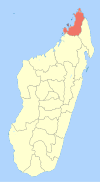
Antsiranana (Malagasy: Antsiran̈ana Malagasy pronunciation: [antsʲˈraŋanə̥]), named Diego-Suarez prior to 1975, is a city at the northern tip of Madagascar.
Antsiranana is the capital of Diana Region.
Climate
| Climate data for Antsiranana | |||||||||||||
|---|---|---|---|---|---|---|---|---|---|---|---|---|---|
| Month | Jan | Feb | Mar | Apr | May | Jun | Jul | Aug | Sep | Oct | Nov | Dec | Year |
| Mean daily maximum °C (°F) | 31.1 (88.0) |
31.3 (88.3) |
31.6 (88.9) |
32.6 (90.7) |
31.8 (89.2) |
30.5 (86.9) |
30.4 (86.7) |
31.2 (88.2) |
32.1 (89.8) |
32.6 (90.7) |
32.4 (90.3) |
31.9 (89.4) |
31.6 (88.9) |
| Mean daily minimum °C (°F) | 25.5 (77.9) |
25.7 (78.3) |
25.6 (78.1) |
25.4 (77.7) |
24.9 (76.8) |
24.2 (75.6) |
23.6 (74.5) |
23.9 (75.0) |
24.9 (76.8) |
24.4 (75.9) |
25.8 (78.4) |
25.7 (78.3) |
25.0 (76.9) |
| Average rainfall mm (inches) | 437 (17.2) |
353 (13.9) |
242 (9.5) |
52 (2.0) |
10 (0.4) |
2 (0.1) |
1 (0.0) |
3 (0.1) |
2 (0.1) |
23 (0.9) |
118 (4.6) |
245 (9.6) |
1,488 (58.4) |
| Average rainy days (≥ 1.0 mm) | 17 | 16 | 12 | 4 | 1 | 1 | 1 | 1 | 1 | 2 | 6 | 13 | 75 |
| Average relative humidity (%) | 82 | 83 | 81 | 73 | 67 | 64 | 62 | 60 | 63 | 66 | 72 | 80 | 71 |
| Mean monthly sunshine hours | 164.3 | 161.0 | 207.7 | 300.0 | 325.5 | 297.0 | 310.0 | 322.4 | 321.0 | 334.8 | 288.0 | 232.5 | 3,264.2 |
| Source: Weltwetter Spiegel Online [1] | |||||||||||||
Transports

Antsiranana has a natural harbour, but the remote location, and, until recently, a bad road to the south, has made it rather unimportant for freight traffic.
History
The place was named for Diogo Soares, a Portuguese navigator who visited the bay in 1543.[2]
In the 1880s, the bay was coveted by France, which desired it as a coaling station for steamships. After the first Franco-Hova War, Queen Ranavalona III signed a treaty on December 17, 1885 giving France a protectorate over the bay and surrounding territory, as well as the islands of Nossi-Be and Ste. Marie de Madagascar.
The colony's administration was subsumed into that of Madagascar in 1896.
The Second Pacific Squadron of Imperial Russia anchored and was resupplied at Diego-Suarez on its way to the Battle of Tsushima in 1905.

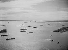
Diego Suárez was one of the points of invasion for Allied forces when they captured Madagascar during 1942. There were fears that Japan would pressure Vichy France into granting use of Madagascar in much the same way as French Indo-China during the previous year. Consequently an invasion of the island was launched. Diego Suarez was selected as the initial invasion point due to its superlative harbour and the fact that it was the seat of many important officials. This was also the site of an attack by Japanese midget submarines on the British fleet.
France continued to use the city as a military base after the Malagasy independence 1960 until the socialist revolution of 1973.
Postage stamps
References
- ^ "Wetter im Detail: Klimadaten". Spiegel Online. 2012. Retrieved on July 19, 2012.
- ^ Pierre Van Den Boogaerde, Shipwrecks of Madagascar, p.40

