Jebel Jais: Difference between revisions
Appearance
Content deleted Content added
m WP:CHECKWIKI error fix. Broken bracket problem. Do general fixes if a problem exists. - using AWB (9449) |
m Added this page to the "Mountains of Oman" Category |
||
| Line 39: | Line 39: | ||
[[Category:Geography of Oman]] |
[[Category:Geography of Oman]] |
||
[[Category:Geography of the United Arab Emirates]] |
[[Category:Geography of the United Arab Emirates]] |
||
[[Category:Mountains of Oman]] |
|||
{{oman-geo-stub}} |
{{oman-geo-stub}} |
||
Revision as of 02:21, 3 January 2014
| Jabal Bil Ays | |
|---|---|
| Highest point | |
| Elevation | 1,934 m (6,345 ft)[1] |
| Prominence | 431 m (1,414 ft) |
| Isolation | 4.92 km (3.06 mi) |
| Listing | Country high point |
| Geography | |
| Location | Oman - United Arab Emirates |
| Region | OM |
| Parent range | Al Hajar Mountains |
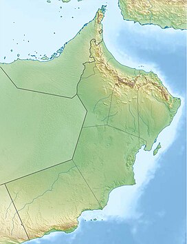
Jabal Bil Ays is a peak on the border between Oman and United Arab Emirates, with an altitude of 1,934 metres (6,345 feet). The highest point of this mountain is located on the Omani side, but an unnamed knoll west of this peak is considered the highest point of the United Arab Emirates, at 1,910 metres (6,266 feet) above sea level. The coordinates of this country high point are 25°56′55″N 56°10′9″E / 25.94861°N 56.16917°E and it is part of the Ras al-Khaimah emirate of the United Arab Emirates.[1]
See also
References
- ^ a b "Jebel Jais" on Peakbagger.com Retrieved 1 October 2011
External links
- Template:En icon Is this the right way to the top?[dead link], The National, February 21, 2009.

