
Sangameshwar: Difference between revisions
Clean up done - removed the broken links, removed the repeated images in the gallery, other spam texts removed |
|||
| Line 71: | Line 71: | ||
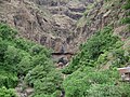
[[Image:Marleshwar entrance.JPG|240px|thumb|right|The Marleshwar temple entrance.]] |
[[Image:Marleshwar entrance.JPG|240px|thumb|right|The Marleshwar temple entrance.]] |
||
* [[Marleshwar]] Cave Shiva Temple, a cave temple located in the Shayadri range about 17 km from Devrukh and 44 km from Sangameshwar Station ([[Konkan Railway]]).. |
* [[Marleshwar]] Cave Shiva Temple, a cave temple located in the Shayadri range about 17 km from Devrukh and 44 km from Sangameshwar Station ([[Konkan Railway]]).. |
||
* [[<ref>Karneshwar Temple</ref>]]. |
|||
* [[Sapteshwar Temple]]. |
|||
* [[Fahim Dalvi's Birthplace]] King Dalvi's fort is there. |
|||
==See also== |
==See also== |
||
[[Marleshwar]] - Waterfall and Shiv Temple. |
|||
{| class="wikitable" style="text-align:center; width:100%;" |
{| class="wikitable" style="text-align:center; width:100%;" |
||
|- |
|- |
||
| Line 92: | Line 90: | ||
==Gallery== |
==Gallery== |
||
<gallery perrow= |
<gallery perrow=8> |
||
Image:Sangameshwar_scenery_01.JPG| |
Image:Sangameshwar_scenery_01.JPG|Sangameshwar scenery |
||
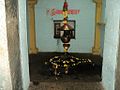
Image:Karneshwar Temple.JPG| |
Image:Karneshwar Temple.JPG|Karneshwar Temple |
||
Image:Karneshwar Temple1.JPG| |
Image:Karneshwar Temple1.JPG|Karneshwar Temple |
||
Image:Suryanarayan Temple.JPG| |
Image:Suryanarayan Temple.JPG|Suryanarayan Temple |
||
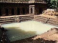
Image:Sapteshwar Temple.JPG| |
Image:Sapteshwar Temple.JPG|Sapteshwar Temple |
||
Image:Sapteshwar Temple2.JPG| |
Image:Sapteshwar Temple2.JPG|Sapteshwar Temple |
||
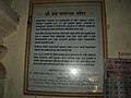
Image:Sapteshwar Temple Information Board.JPG| |
Image:Sapteshwar Temple Information Board.JPG|Sapteshwar Temple Information Board |
||
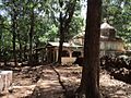
Image:Sangameshwar-Marleshwar_Road_01.JPG| |
Image:Sangameshwar-Marleshwar_Road_01.JPG|Devrukh - Marleshwar road |
||
Image: |
Image:Marleshwar_waterfall.JPG|[[Marleshwar]] waterfall |
||
Image:Sangameshwar-Marleshwar_Road_03.JPG|10.> Devrukh - Marleshwar road. |
|||
Image:Marleshwar_waterfall.JPG|11.> [[Marleshwar]] waterfall. |
|||
Image:Marleshwar_01.JPG|12.> [[Marleshwar]]. |
|||
Image:Marleshwar_02.JPG|13.> [[Marleshwar]]. |
|||
Image:Marleshwar_03.JPG|14.> [[Marleshwar]]. |
|||
Image:Marleshwar_04.JPG|15.> [[Marleshwar]]. |
|||
Image:Marleshwar_05.JPG|16.> [[Marleshwar]]. |
|||
Image:Marleshwar_06.JPG|17.> [[Marleshwar]]. |
|||
Image:Marleshwar_07.JPG|18.> [[Marleshwar]]. |
|||
</gallery> |
</gallery> |
||
Revision as of 14:08, 9 May 2014
Sangameshwar Taluka
संगमेश्र्वर तालुका Sangameshvar Taluka | |
|---|---|
taluka | |
| Country | |
| State | Maharashtra |
| District | Ratnagiri |
| Languages | |
| • Official | Marathi |
| Time zone | UTC+5:30 (IST) |
| PIN | 415611 |
| Telephone code | 02354 |
| Vehicle registration | MH-08 |
Sangameshwar Taluka is a taluka in Ratnagiri subdivision of Ratnagiri district in the Indian state of Maharashtra. The headquarters for the taluka is the town of Devrukh.[1] In Sangmeshwar the two rivers Sonavi and Shastri flow together. In fact, the very meaning of Sangama in Marathi is confluence, and so the name "Sangmeshwar". It is historically important as the place where Sambhajiraje, son of Chhtrapati Shivaji was captured by Mughal Emperor Aurangzeb.[2] Sambhaji was tortured and executed in Tulapur.
Geography
The city lies on the join of two banks of the River Shatri and River Sonavi. To the east of the city lie the Western Ghats and to the west lies Ganapatipule. The region has a tropical climate. The 'rainy season' — the monsoon lasts normally from June till October.
Transportation
The nearest bus stand is Sangameshwar S.T. Stand (M.S.R.T.C.) nearly 4 km from Sangameshwar Railway Station. The Sangameshwar railway station is located on National Highway 17 (Mumbai - Goa Highway). The nearest main bus depot is Devrukh of (M.S.R.T.C.) nearly 13 km from Sangameshwar S.T. Stand from where you can reach to Sakharapa and then kolhapur also from Devrukh you can reach to Ratnagiri and Lanja city.
Attractions

- Marleshwar Cave Shiva Temple, a cave temple located in the Shayadri range about 17 km from Devrukh and 44 km from Sangameshwar Station (Konkan Railway)..
See also
Marleshwar - Waterfall and Shiv Temple.
| Sangmeshwar Road (SGR) [संगमेश्र्वर रोड] | |||
| Next 'Small' station towards Mumbai: Aravli Road |
Konkan Railway : Railway (India) | Next 'Small' station from Mumbai: Ukshi | |
| Distance from Mumbai(CSTM) = 0384 KM | |||
| Next 'Main' station towards Mumbai: Chiplun |
Konkan Railway : Railway (India) | Next 'Main' station from Mumbai: Ratnagiri | |
Gallery
-
 Sangameshwar scenery
 -
 Karneshwar Temple
 -
 Karneshwar Temple
 -
 Suryanarayan Temple
 -
 Sapteshwar Temple
 -
 Sapteshwar Temple
 -
 Sapteshwar Temple Information Board
 -
 Devrukh - Marleshwar road
 -
 Marleshwar waterfall


References
- ^ The headquarters was moved from the village of Sangameshvar to Devrukh in 1878."Devrukh". Ratnagiri District.
- ^ Alexander Mikaberidze (31 July 2011). Conflict and Conquest in the Islamic World: A Historical Encyclopedia. ABC-CLIO. p. 609. ISBN 978-1-59884-337-8. Retrieved 6 March 2012.