
Talk:Control of cities during the Syrian civil war: Difference between revisions
m Signing comment by 92.44.118.134 - "→Regiment 121 for IS and Khitab for rebels: " |
|||
| Line 684: | Line 684: | ||
Daily Star is a neutral source and a respect newspaper. <span style="font-size: smaller;" class="autosigned">— Preceding [[Wikipedia:Signatures|unsigned]] comment added by [[Special:Contributions/201.22.81.30|201.22.81.30]] ([[User talk:201.22.81.30|talk]]) 10:58, 27 July 2014 (UTC)</span><!-- Template:Unsigned IP --> <!--Autosigned by SineBot--> |
Daily Star is a neutral source and a respect newspaper. <span style="font-size: smaller;" class="autosigned">— Preceding [[Wikipedia:Signatures|unsigned]] comment added by [[Special:Contributions/201.22.81.30|201.22.81.30]] ([[User talk:201.22.81.30|talk]]) 10:58, 27 July 2014 (UTC)</span><!-- Template:Unsigned IP --> <!--Autosigned by SineBot--> |
||
Fuck off with your dailystar and SOHR crap. Prove it or stop posting bullshit. dailystar is anti Assad. |
|||
== Regiment 121 for IS and Khitab for rebels == |
== Regiment 121 for IS and Khitab for rebels == |
||
Revision as of 18:52, 27 July 2014
| This is the talk page for discussing improvements to the Control of cities during the Syrian civil war article. This is not a forum for general discussion of the article's subject. |
Article policies
|
| Find sources: Google (books · news · scholar · free images · WP refs) · FENS · JSTOR · TWL |
| Archives: Index, 1, 2, 3, 4, 5, 6, 7, 8, 9, 10, 11, 12, 13, 14, 15, 16, 17, 18, 19, 20, 21, 22, 23, 24, 25, 26, 27, 28, 29, 30, 31, 32, 33, 34, 35, 36, 37, 38, 39, 40, 41, 42, 43, 44, 45, 46, 47, 48, 49, 50, 51, 52, 53, 54, 55, 56, 57, 58, 59, 60, 61, 62, 63, 64, 65Auto-archiving period: 14 days |
| This page is not a forum for general discussion about Control of cities during the Syrian civil war. Any such comments may be removed or refactored. Please limit discussion to improvement of this article. You may wish to ask factual questions about Control of cities during the Syrian civil war at the Reference desk. |
| This article is of interest to the following WikiProjects: | |||||||||||||||||||||||||||||||||||||||||||||
| |||||||||||||||||||||||||||||||||||||||||||||


.svg)
| To help centralise discussions and keep related topics together, Template talk:Syrian Civil War detailed map redirects here. |
Template:Syrian Civil War sanctions
|
Index 1, 2, 3, 4, 5, 6, 7, 8, 9, 10 |
|
This page has archives. Sections older than 14 days may be automatically archived by Lowercase sigmabot III when more than 4 sections are present. |
Deir Ez Zor contryside
SOHR reported that the rebels took control of many villages after clashes against ISIS https://www.facebook.com/syriahroe/posts/536128479828828 waiting for more sources FS1991
Khalfatli
According to SOHR, this border town is currently controlled by ISIS. https://www.facebook.com/photo.php?fbid=10152562069038115
SOHR not neutral source
Dear editors due to the fact that there are editors which said that the data which are published the SOHR are not reliable I decided to explore all the data relating to this source. And in the process of exploring the many data I came to concluded that this source is anti-government and pro opposition source and all its data are largely based on data of opposition activists and rebels and thus its data can not be used to display the achievements of rebels in clashes against the Syrian army. Because it is the same if we used the data from the SANA to display success of army. Here's confirmation that the SOHR is opposition source and this is confirmed by many reliable sources: read this article in Wikipedia, Also Reuters said that the SOHR it is anti-Assad grouphereand here Also Chicago Tribune said that the SOHR it is anti-Assad group.here and it also confirms First Post and ABC NewsJerusalim PostBusiness InsiderFree Malaysia TodayNews Week So that none of the editors should be no doubt that the SOHR can no longer be used to display the progress of the rebels against the Syrian army. Or should we then use SANA Al Manar of Fara News to display the progress of the army. But otherwise, we also can used data from government sources about such as SANA Al Manar of Fara News to display progress of the army. And that would not break the rules, we must use to edit on the map the data of SOHR or SANA only if their data confirmed the reliable sources. Hanibal911 (talk) 15:45, 7 July 2014 (UTC)
- This discussion has been had, and is closed. You can re-read it in the archives of this talk page if you need refreshing - SOHR CAN and WILL be used to validate advances by ALL sides; SANA, Al-Manar, and Fars cannot be used for gov't advances, without confirmation from alternately aligned outlets. This is an established rule for this map. If you do not abide by it, if you revert edits based on SOHR, or try to edit based exclusively on SANA, Al-Manar, or Fars, I will pursue disciplinary measures against you. It is clear what your intention is. Write off the SOHR and 99% of rebel achievements will go unreported on this map - because 99% of non-gov't aligned news outlets cite the SOHR. The SOHR is the only source that reports EVERYONE'S gains and losses, so just drop it. Boredwhytekid (talk) 16:39, 7 July 2014 (UTC)
- You are broke the rules the edit on this map when you put the green circle near the town which, under the control of the army on the basis of data that said that the rebels only shelled a city. And if you check out all my changes you'll see that I always revert the edits that were made on the basis of government sources to reflect the success of the army. So dont need accuse me of vandalism. And about the source SOHR in Wikipedia clearly states that this is the anti government source.here Hanibal911 (talk) 17:07, 7 July 2014 (UTC)
- That source does not only say they shelled a city, it says they are close enough to fire machine guns into it - that's a difference of being miles away, and being meters away. And how many red circles have popped up around rebel-held towns that are not besieged, but only shelled? Kfar Laha, Tal Dahab, Kissin, basically the entire Homs plains area. Look, I don't have a dog in this fight, but I'm not sitting back and watching you eliminate the most reliable source that we have. I'm not here to argue with you, I'm here to recreate the clearest possible picture of the situation on the ground in Syria. You wanna press this topic, go for it, but you won't get anywhere.. Boredwhytekid (talk) 17:17, 7 July 2014 (UTC)
- We noted these cities because they are in the area which surrounded the Syrian army although I also do not quite with these agree. I think that we need to add an icon that will mean that there are clashes near the city and it should be a icon of the neutral color and so our map gain more relevance. Hanibal911 (talk) 17:28, 7 July 2014 (UTC)
- Yea, we really need an icon for outskirts/environs/vicinity clashes. Boredwhytekid (talk) 17:37, 7 July 2014 (UTC)
- How do you feel about the fact that we will mark it is icon
 when clashes near the town. Hanibal911 (talk) 17:46, 7 July 2014 (UTC)
- How do you feel about the fact that we will mark it is icon
- As in, put as a concentric circle around a town when there's fighting on the outskirts? And only make it the color of one of the combatant parties when it is truly under siege? In theory, sounds good. It would take a lot of editing, and probably arguing lol to implement.. Boredwhytekid (talk) 17:56, 7 July 2014 (UTC)
- We need to put this icon when the source said that fighting is near the city or in its immediate vicinity of the city it is will more precise. Hanibal911 (talk) 18:03, 7 July 2014 (UTC)
- I'm in. Let's put it to a decision. Boredwhytekid (talk) 18:07, 7 July 2014 (UTC)
- But we must be sure that it is really clashes near the city and not only hit and run. Otherwise, we can distort the map. Hanibal911 (talk) 18:12, 7 July 2014 (UTC)
- See, there's where we're going to run into trouble - everyone is going to have a different opinion on what constitutes "clashes" and we'll never all agree. Even hit and run is technically guerilla warfare - if it happens once, ok yea no reason to put the icon - but if it's hit and run attacks for weeks running, like in Qalamoun, what then? Some say circle, some say no.. Boredwhytekid (talk) 18:23, 7 July 2014 (UTC)
Many SOHR reports are true but not all because this is a pro insurgent source is the equivalent to use Syrian Perspective, used only this SOHR to showing insurgents gains (All factions) on map against the government is against the rules.--Pototo1 (talk) 13:11, 17 July 2014 (UTC)
Merger
Hello all, I realize this might be a stretch to suggest, but you do you all think about merging this template with Iraqi Insurgency Detailed Map. The happenings on the ground in one country produce dramatic changes in the other. Furthermore, we can title it Military Conflict in Mesopotamia or something along those lines. What do all of you think? Malik Danno (talk) 16:47, 7 July 2014 (UTC)
- I am all for your suggestion, but doubt that I have the technical wherewithal to assist in making it a reality. My vote's a "yes" though. Boredwhytekid (talk) 16:50, 7 July 2014 (UTC)
![]() Oppose - While the two conflicts have some connections (wars in neighbouring countries always have them), its a non-sense to simply mix them in a common map. This is not the "First Mesopotamic War", but two differenced conflicts with different actors, different causes, and different developments, and with a few common issues (mostly ISIS & the Kurds issue), clearly not enough for the merge, I think.--HCPUNXKID 17:19, 7 July 2014 (UTC)
Oppose - While the two conflicts have some connections (wars in neighbouring countries always have them), its a non-sense to simply mix them in a common map. This is not the "First Mesopotamic War", but two differenced conflicts with different actors, different causes, and different developments, and with a few common issues (mostly ISIS & the Kurds issue), clearly not enough for the merge, I think.--HCPUNXKID 17:19, 7 July 2014 (UTC)
Tens of thousands of Iraqi militia fighting in Syria; The Syrian air force bombing inside of Iraq; a pseudo state straddling the former borders of Syria and Iraq; the Kurds. Haha what more do you want? It's a regional war! Ours could be the only map showing the entirety of the IS boundaries, everyone and every place they are fighting, and just the general situation in these two countries. Boredwhytekid (talk) 17:23, 7 July 2014 (UTC)
I support it but in a different file, this means keep this and the iraqi map and make a third one that has both conflicts and keep it updated — Preceding unsigned comment added by 142.197.58.143 (talk) 18:08, 7 July 2014 (UTC)
- There's a compromise. Any other takers? Sounds like a worthwhile project..Boredwhytekid (talk) 18:18, 7 July 2014 (UTC)
Agree, a third map with both countries would be great, as would links to the Iraq map on this page and vice versa. — Preceding unsigned comment added by 24.0.9.59 (talk) 18:54, 7 July 2014 (UTC)
Probably also add Lebanon into the mix because fighting there is inevitable as ISIS spreads its influence in the region — Preceding unsigned comment added by 142.197.58.143 (talk) 16:37, 8 July 2014 (UTC)
can you make it where updates continue to be made to the two separate map file but that another page merges the two updating maps so that people have the possibility of viewing a map of the two countries together? so this way need changes and debates would not be occurring over this merged map- instead if would just reflect the two separately updating maps. — Preceding unsigned comment added by 169.231.115.81 (talk) 21:09, 8 July 2014 (UTC)
- Automatic merging sounds like a good idea, if possible. The 2 maps might have to have the same scale. (Don't know if that is the case.)
- If not, it would be a good idea to require that the combined map only echo info on the 2 separate maps, so it could be updated by just surveying the changes on the 2 maps. A lot less work that way.
- Luckily the same colours for the same parties are used, as well as the same icons, although the Syrian regime (red) is not necessarily the same as the Iraqi regime (also red). André437 (talk) 19:40, 9 July 2014 (UTC)
- How do we make this a reality / what needs to be done / I'm excited about the prospect, how can I help? Boredwhytekid (talk) 20:11, 9 July 2014 (UTC)
- 1) First a combined background image has to be made, easier if they already have the same scale.
- 2) Then do the basic map definition. This gives the longitude/latitude of the edges of the background image, among other things.
- 3) Then make the template. This includes the caption, size, etc. This could be done by simply copying the Syria map template to a new name, and modifying the important factors, such as the basic map definition. To make everything fit when adding Iraq, some locations in uncontested regions might have to be deleted. (e.g., the tiny island of Arwad, just off Tartus, which inexplicably was added as regime held. The last conflict there was probably not in this century.)
- 4) On an ongoing basis, add (and maybe subtract) locations to the combined map. Just like is done with Syria, and many other similar maps. Note that since we would be basing items on the combined map on the 2 existing maps, there shouldn't be the constant controversy evident in updating the Syria map.
- 5) Also note that in the design of the Syria map, the related tables were supposed to be updated before posting to the map. Evidently that is no longer being done, so verifying the current status of various locations is next to impossible.
- 6) As a final note, if any editors are unsure of the format, they should ask on this page. Too much editing is poorly done. André437 (talk) 06:48, 10 July 2014 (UTC)
- Don't bother... Just look at this one below. It is regularly updated by user Spesh531 based on our map & Iraq map... Tradediatalk 16:09, 11 July 2014 (UTC)

- Don't bother... Just look at this one below. It is regularly updated by user Spesh531 based on our map & Iraq map... Tradediatalk 16:09, 11 July 2014 (UTC)

- Nice map. It has the advantage of slightly different colours for the Syrian and Iraqi regimes, as well as the Syrian and Iraqi kurds. Appropriate since they are all independent groups.
- It does however put the 2 Syrian kurdish groups the same colour, even though al Akrad cooperates very closely with and fights alongside the FSA, which is not always the case for the YPG.
- I wonder what sources they use for control of the countryside outside the cities and towns ? It can't be from either our or the Iraqi map. It shows the kurds controlling a lot of the countryside outside ISIS controlled towns in Iraq, which would indicate a tenuous hold by the ISIS.
- And the rebellion in Syria controlling very little of the countryside around their towns, to the advantage of the regime and the ISIS. Yet the rebellion has been able to transfer forces quite freely between towns held in different provinces. André437 (talk) 18:33, 12 July 2014 (UTC)
![]() Comment: So, now the people who wanted to merge the maps you have a map (Spesh531 one) portraying Syria & Iraq together, so no need to merge any other maps.--HCPUNXKID 12:21, 13 July 2014 (UTC)
Comment: So, now the people who wanted to merge the maps you have a map (Spesh531 one) portraying Syria & Iraq together, so no need to merge any other maps.--HCPUNXKID 12:21, 13 July 2014 (UTC)
Tishrin Dam contested
This edit request to Template:Syrian Civil War detailed map has been answered. Set the |answered= or |ans= parameter to no to reactivate your request. |
Tishrin Dam contested ISIS-FSA/IF per pro-gov't http://www.syrianperspective.com/2014/07/al-raqqa-province-updated-map.html Would someone please make this change before it becomes outdated? Boredwhytekid (talk) 12:23, 9 July 2014 (UTC)
- But as we can noted if dam contested. And what should be the icon. We can mark it of this icon or simply mark the different color.
 or File:BSicon STRlg brown.svg Hanibal911 (talk) 13:16, 9 July 2014 (UTC)
My vote is for ![]() , but I leave that to you. Boredwhytekid (talk) 13:36, 9 July 2014 (UTC)
, but I leave that to you. Boredwhytekid (talk) 13:36, 9 July 2014 (UTC)
 Not done: it's not clear what changes you want to be made. Please mention the specific changes in a "change X to Y" format. —cyberpower ChatOnline 08:24, 20 July 2014 (UTC)
Gire sor, Kobane
This edit request to Template:Syrian Civil War detailed map has been answered. Set the |answered= or |ans= parameter to no to reactivate your request. |
Gire sor is on the map 2x, right next to itself.
per wikimapia, this is the location http://wikimapia.org/#lang=en&lat=36.701165&lon=38.799162&z=16&m=b Boredwhytekid (talk) 17:34, 9 July 2014 (UTC)
- Not done: it's not clear what changes you want to be made. Please mention the specific changes in a "change X to Y" format. I'm not seeing it. —cyberpower ChatOnline 08:34, 20 July 2014 (UTC)
Alirhejan
This edit request to Template:Syrian Civil War detailed map has been answered. Set the |answered= or |ans= parameter to no to reactivate your request. |
Allegedly this village, or HQ has been captured by Al Nusre fighters this morning. video pic tw pic
109.175.40.147 (talk) 15:29, 11 July 2014 (UTC)
- Not one of your sources can not be used since they are not reliable. And we can not use pro rebel sources to show success of rebels. Hanibal911 (talk) 15:37, 11 July 2014 (UTC)
Video posted by Al Jazeera and a picture showing one of the captured tanks — Preceding unsigned comment added by DuckZz (talk • contribs) 18:04, 13 July 2014 (UTC)
- In your video not said that the village of captured! And here Al Jazeera said that the rebels have captured only part of the village.Al Jazeera Also SOHR said that: Jabhat al-Nusra have taken over wide parts of the western side of al-Rahjan village, in the eastern countryside.SOHR Hanibal911 (talk) 19:29, 13 July 2014 (UTC)
 Not done: please provide reliable sources that support the change you want to be made. —cyberpower ChatOnline 08:36, 20 July 2014 (UTC)
Assal al-Ward Should be have full red again
We talked about Assal al-Ward before here here
The town is under government control Since May 2014 According Different Official Syrian TV Reports =
Latter in this other Syria TV Report showing in June 19 this place stable and under government control Other report from Lebanon News Agency elnashra from June 21 showing the whole town stable under Army control this another report dated in June 18 Alikhbaria TV showing the Syrian Refuges returning from Lebanon to Assal al-Ward, this is a proof there in Assal al-Ward are not a blocked / Besieged in nowhere and roads are working.
The ANTI GOVERMENT SOHR IS NOT A RELIABLE SOURCE AT ALL BECAUSE THEY SUPPORT THE INSURGENTS they were who claim days ago the Insurgents clashed with Army AWAY IN THE WEST VICINITY to Assal al-Ward, and yes it happens but they NOT Blocked the west of the Town and the Insurgents latter retreat here is the SANA report from this area AFTER the clashed IN THE WEST VICINITY to Assal al-Ward -
- Wiki map from Qalamoun
- Finally according this No pro Government Source dailystar confirmed the west from Assal al-Ward is open to the Army.
I think we satisfied enough time the user Boredwhytekid keeping a PERMANENT Insurgent presence in WHOLE west close to the Town who no exit more than a week... This is Cities and Town map, this map is not about held territory, the map about held territory is this one — Preceding unsigned comment added by LogFTW (talk • contribs) 19:57, 12 July 2014 (UTC)
who wrote all this, deserves medal!!!! well done!!! — Preceding unsigned comment added by 85.94.121.58 (talk) 08:47, 13 July 2014 (UTC)
^ Not really dude . There just are a fact the west of Assal al-Ward it's not blocked besiege by Insurgents a lot sources confirmed that --LogFTW (talk) 14:53, 13 July 2014 (UTC)
-Sigh- It seems you want to have this conversation weekly. #1, per the rules of this map, none of your sources can be used to reverse rebel gains except the Daily Star one, and even that article is just citing a Lebanese security official. #2, even that source is outdated by http://www.dailystar.com.lb/News/Lebanon-News/2014/Jul-08/263005-border-rebels-resist-hezbollah-regime.ashx#axzz36saWUB14. #3, the concentric circle icon -on this map- does not necessarily mean besieged; it is also used to indicate fighting in the environs/outskirts (otherwise, remove the red circles from Kfar Laha, Tal Dahab, Taldou, and the rest of the Homs plain rebel-held towns that are not besieged.. the fact that you are not arguing for them as well reveals your BIAS) #4, even SANA is still admitting clashes around Assal al-Ward http://www.sana.sy/en/?p=6019 - "Army units continued pursuing terrorists in the wilderness around Ras al-Maara and Assal al-Ward in al-Qalamoun area on the Syrian-Lebanese borders." #5, you keep saying that this is just a cities and towns map, but that ceased to be true when army bases, airfields, oil processing plants, dams, and other strategic sites were added - long ago. #6, look, barring the miraculous, the SAA will clear Qalamoun in the next month or two - seeing as how the rebels are completely isolated and are slowly being squeezed. Until such time though, we will indicate the rebel presence if for no other reason than that IT'S THE TRUTH OF THE SITUATION ON THE GROUND.
I know you'll write a rambling dissertation of a response in perpetuity.. but just so you know, I'm not commenting on this anymore, because it goes no where with you. I don't want to edit war, but if you change the status (before the SAA truly does clear the region) I will keep reverting. Boredwhytekid (talk) 15:07, 13 July 2014 (UTC)
- Towns located in the Qalamoun area under the control of the army but the rebel groups maintain its presence in a mountainous area near the Lebanese border where now the army and Hezbollah leads offensive against the rebels. So pro opposition source said that five Hezbollah fighters and 30 Syrian opposition fighters were killed in fierce clashes in the vicinity of the city Arsal in southern Lebanon, according to a security source. The sources, speaking on condition of anonymity, told Anadolu Agency that clashes had erupted between the Hezbollah fighters and the rebels who had taken refuge in the border area between Syria and Lebanon after Syrian government forces had seized control of the town of Qalamoun in northern Syria nearly a month ago.World Bulletin Hanibal911 (talk) 07:49, 14 July 2014 (UTC)
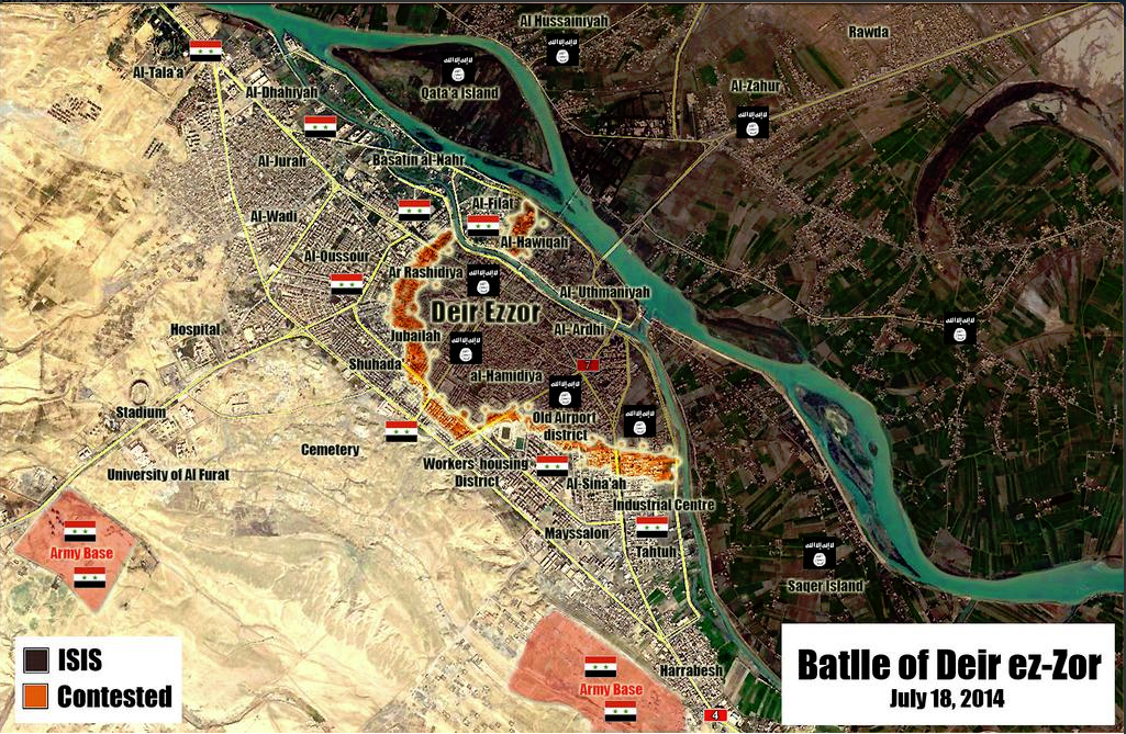
Islamic State (IS) in Deir El-Zour
ISIS took controll of the opp held part of Deir El-Zour city according to pro opp source http://www.aljazeera.net/news/arabic/2014/7/14/%D8%AA%D9%86%D8%B8%D9%8A%D9%85-%D8%A7%D9%84%D8%AF%D9%88%D9%84%D8%A9-%D9%8A%D8%B3%D9%8A%D8%B7%D8%B1-%D8%B9%D9%84%D9%89-%D8%AF%D9%8A%D8%B1-%D8%A7%D9%84%D8%B2%D9%88%D8%B1-%D9%88%D8%A7%D8%B4%D8%AA%D8%A8%D8%A7%D9%83%D8%A7%D8%AA-%D8%A8%D8%A7%D9%84%D9%82%D9%84%D9%85%D9%88%D9%86 (Ali bachir (talk) 21:09, 14 July 2014 (UTC))
Semi-protected edit request on 14 July 2014
This edit request to Template:Syrian Civil War detailed map has been answered. Set the |answered= or |ans= parameter to no to reactivate your request. |
Two excessive objects:
1)the entry with label=[[Gire Sor]] and link=#Bagdîk (previous have the same link, and the next have resembling label),
2)Lahaya in two positions (red and lime circles for both).
87.117.178.100 (talk) 21:31, 14 July 2014 (UTC)
 Done
Done
Qalamoun area
Would it be possible to include Ersal in Lebanon as opposition (green) held? This article in Al Akhbar discusses the area, and also includes this line: “The Syrian army controls the villages of Nabek, Qara, and Falita but not their outskirts, which allows [militants] to move across the border.” I'm not sure if these towns are all present on the map. http://english.al-akhbar.com/content/ersal-executions-assassinations-and-chaos — Preceding unsigned comment added by 169.231.67.15 (talk) 16:56, 15 July 2014 (UTC)
- This map shows the situation in the cities and villages and the army controls nearly the entire area Qalamoun but rebels are present in the border area. But we can not display on this map the situation in neighboring Lebanon. But if you're wondering more detail situation you can see on this map.here Hanibal911 (talk) 17:59, 15 July 2014 (UTC)
Rahjan in Hama province was in red why some one change it to contested ?
Why some one change Rahjan to red to contested ?
If the only source is the SOHR or another pro insurgent page it must be change to red is against the rules used pro Insurgent sources to showing Insurgents gains.
Links your sources or it must be back to red We have rules and it's for all towns.
BTW some people confused when they read in SOHR facebook page "Clashed in the Vicinity" or "Clashed near" - Clashed in the Vicinity / Near the town is different than combats inside the town. — Preceding unsigned comment added by 190.203.205.104 (talk) 03:57, 16 July 2014 (UTC)
Semi-protected edit request on 16 July 2014
This edit request to Template:Syrian Civil War detailed map has been answered. Set the |answered= or |ans= parameter to no to reactivate your request. |
ISIS have taken controll of the Opp held part of Deir El-Zour City according to several pro opp sources, it should be changed from green to black.
http://arabic.cnn.com/middleeast/2014/07/14/isis-syria-dair-alzour?hpt=continous http://www.aljazeera.net/news/arabic/2014/7/14/تنظيم-الدولة-يسيطر-على-دير-الزور-واشتباكات-بالقلمون http://www.alaraby.co.uk/politics/632f802b-1e17-4e6f-8805-cb6bed71bf61
85.195.139.195 (talk) 15:04, 16 July 2014 (UTC)
 Question: Could you be a little clearer. I'm not able to find that point on the map, if I'm reading it correctly. If you understand Wiki markup pretty well can you provide an X to Y answer. If not, can you provide the coordinates. I may be able to make better use of it. —cyberpower ChatOnline 18:45, 21 July 2014 (UTC)
Al Samdaniyah and Tal Krum
According to documents.sy Syrian army takes control over al-Samadaneya al-Sharkeia and Tal Krum towns of al- #Qunaitera countryside. near madinath al bath and jaba https://www.facebook.com/documents.sy/posts/754358694626889 — Preceding unsigned comment added by 5.46.50.190 (talk) 21:28, 16 July 2014 (UTC)
Brigade 61, Hanajak and Sheik Al Sa'ad
This edit request to Template:Syrian Civil War detailed map has been answered. Set the |answered= or |ans= parameter to no to reactivate your request. |
I can't find the Sheik Sa'ad checkpoint on the map, maybe you have put some different name or ? Tour trought brigade 61 and Hanajak 2 tweets, still waiting for an neutral source, and actually I was only interested for the first checkp. DuckZz (talk) 22:14, 16 July 2014 (UTC)
- Not done: please provide reliable sources that support the change you want to be made. —cyberpower ChatOnline 18:49, 21 July 2014 (UTC)
Semi-protected edit request on 17 July 2014
This edit request to Template:Syrian Civil War detailed map has been answered. Set the |answered= or |ans= parameter to no to reactivate your request. |
in 7/11/2014 YPG withdraw from Kandal village west of Tall Abyad in Raqa Province and it is under IS control. Koroqu village west of Ayn Al-Arab(Kobani) is contested by IS and YPG. IS send a Suicide Motorcycle to a YPG checkpoint in Koroqu. The Suicide attack resulted in the death of IS attacker with no casualties reported by YPG. Sarmedwhivan2004 (talk) 03:18, 17 July 2014 (UTC)
- Please leave a space line before and after headings (== ... ==), otherwise it risks being merged with the previous section (as happened this time).
- Also please add a comment to your edit request instead of duplicating your edit request with the added comment. André437 (talk) 05:12, 18 July 2014 (UTC)
- Not done: please provide reliable sources that support the change you want to be made. —cyberpower ChatOnline 18:30, 21 July 2014 (UTC)
Semi-protected edit request on 17 July 2014
This edit request to Template:Syrian Civil War detailed map has been answered. Set the |answered= or |ans= parameter to no to reactivate your request. |
in 7/11/2014 YPG withdraw from Kandal village west of Tall Abyad in Raqa Provimce and it is under IS control. Koroqu village west of Ayn Al-Arab(Kobani) is contested by IS and YPG. IS send a Suicide Motorcycle to an YPG checkpoint in Koroqu. The Suicide attack resulted in the death of IS attacker with no casualties reported by YPG.
reference http://www.alaan.tv/news/world-news/109044/battles-in-the-countryside-of-raqqa-and-ain-arab-between-isis-and-kurds-syria Sarmedwhivan2004 (talk) 03:19, 17 July 2014 (UTC)
- Not done: it's not clear what changes you want to be made. Please mention the specific changes in a "change X to Y" format. —cyberpower ChatOnline 18:49, 21 July 2014 (UTC)
Quruqo Should be changed from "yellow" to "yellow and black"(contested)
Tasil and Adwan
is it still possible that these villages are still contested,although the opposition seized sheikh saad and the base near it.Alhanuty (talk) 15:44, 17 July 2014 (UTC)
- In response to recent events perhaps we need to searching more information about the situation in this area and try to clarify the situation with these cities. Hanibal911 (talk) 16:17, 17 July 2014 (UTC)
why Rahjan in Hama was change to red to green ?
Some one is changing this town to contested and latter to green but this place was in red according to previously map.
If you have a source I want to see that remember the SOHR, pro Insurgents twitters accounts are not sources is against the rules used anti government sources to showing progress from insurgensts (All insurgents) against the government.
I think If nobody have solid sources Rahjan in Hama should be change to red again. --Pototo1 (talk) 23:04, 17 July 2014 (UTC)
if you check the history edit,you will see that there was a source mentioned. Alhanuty (talk) 02:33, 18 July 2014 (UTC)
I no found just link that if you have that. --Pototo1 (talk) 05:19, 18 July 2014 (UTC)
http://syriahr.com/index.php?option=com_news&nid=21059&Itemid=2&task=displaynews. Alhanuty (talk) 22:09, 21 July 2014 (UTC)
Is against the rules used anti government sources to showing anti government insurgent gains- Have something different ?--LogFTW (talk) 03:35, 22 July 2014 (UTC)
In this pro insurgent source are not direct mention about Rahjan on text it meaning to 300+ killed on Gas camp in Homs, the insurgents here probability meaning to this place to "Syrian the defense minister's village" on the tittle only, but there are not a single source who suggests the insurgents captured it at all.
Here said the insurgent just "Attack" with truck bomb they no controlled that, they attack before the location with truck bomb too according with this another source and the location was keeping on red.
Personally I think the insurgents controlling nothing there, seem is just blah blah blah from SOHR who support the Insurgents but based on the sources (Who quoiting the SOHR) the most pro Insurgent decision who we can do is but the place contested.
- You cite http://news.yahoo.com/syrian-rebels-attack-defense-ministers-village-122651803.html and say it doesn't say rebels took any of the village, but it does (SOME of the village). Here's a Kurdish source which is NOT citing SOHR http://aranews.net/2014/07/syria-rebels-advance-hama/ that claims rebels took the entire thing. Contested is probably the way to go.. Do you have any sources to the contrary? Boredwhytekid (talk) 20:33, 22 July 2014 (UTC)
- Ara News is the pro opposition Kirdish source which support by rebels and it cant be used for display rebel advances against the army. Hanibal911 (talk) 20:45, 22 July 2014 (UTC)
- Pro-Kurdish outlets are as anti-FSA and anti-IS as they are anti-Assad.. in this conflict the Kurds have spent more time fighting FSA and IS than Assad anyway. "Opposition" is too sweeping of a term - especially when groups covered by that umbrella term are literally killing each other..Boredwhytekid (talk) 12:28, 23 July 2014 (UTC)
I no found a single source with "Credibility" who suggests the insurgent controlled this place The Washington Times and same case they just "Attack" the village with a car bombs and "Control" Severals parts but never said the Insurgents captured it at all.
I no have problem you can keep it on green but if we take these pro insurgents claims as true we need to used Syrian Perspective Reports as true too who many times are refused --Pototo1 (talk) 13:24, 23 July 2014 (UTC)
desyracuse It's not a source use it could be against the rules-
Everyone can do a map like that and publish it on twitter any mortal with brain working at 10% can do it http://umap.openstreetmap.fr/fr/map/desyracuse-syria-civil-war-7-july-2014_12153#9/35.3935/37.3178 don't clone that map here -
For change the color for specific town (or add news towns) you need a specific sources from specific town please don't ruin all the map again.
If the pro government source, anti government and "Neutrals" like CNN / BBC, Reuther etc coincided two or all the change is made. --Pototo1 (talk) 22:46, 17 July 2014 (UTC)
deir el zor province
according to sohr IS took control over Deir Ezzor Province completely except the regime- held areas . No rebels or locals inside deir el zor province — Preceding unsigned comment added by 5.46.85.148 (talk) 17:30, 18 July 2014 (UTC)
source: https://www.facebook.com/syriahroe/posts/556874567754219 — Preceding unsigned comment added by 5.46.85.148 (talk) 17:35, 18 July 2014 (UTC)
I will change from blue to black because the source is newer and more neutral (the Institute has shown pro-opp tendencies in the past). Besides, reports do say that generally in all of the ISIS territories ISIS leaves local tribes to administer themselves while their troops go to the frontlines (same goes for Iraq). EkoGraf (talk) 18:16, 18 July 2014 (UTC)
I disagree on changing some towns from red to black based on SOHR info in DierErZoor as Ayyash. In fact the following day, this citu was confirmed [1] to be under government control. Paolowalter (talk) 10:13, 19 July 2014 (UTC)
Semi-protected edit request on 18 July 2014
This edit request to Template:Syrian Civil War detailed map has been answered. Set the |answered= or |ans= parameter to no to reactivate your request. |
Two black circles for Khasham, need to remove the excess. 87.117.178.100 (talk) 20:38, 18 July 2014 (UTC)
 Done I removed the larger one. If you wanted me to remove the smaller one, let me know. —cyberpower ChatOnline 18:52, 21 July 2014 (UTC)
New Deir Ez Zor Map
The most recent is pro government but credibility is good http://i.gyazo.com/c1a9a9004995f0ee25ec9a47cc8a9418.png — Preceding unsigned comment added by Pototo1 (talk • contribs) 20:41, 18 July 2014 (UTC)
Idlib Provience change
These villages are under the control of SAA :Al-Basheeriyya, Miland, Judaydat Al-Jisr, Duwwayr Al-Akraad http://www.syrianperspective.com/2014/07/syrian-army-deep-in-mork-saa-routs-rats-in-idlib-and-aleppo-50-dead-terrorists-in-aleppo.htmlMZarif (talk) 17:14, 19 July 2014 (UTC)
This source is strongly biased pro-government and therefore it is not reliable. We must have additional neutral or pro-opposition sources before updating the map. Paolowalter (talk) 21:23, 19 July 2014 (UTC)
Shaer Gas field
This edit request to Template:Syrian Civil War detailed map has been answered. Set the |answered= or |ans= parameter to no to reactivate your request. |
First of all I thought Shaer was a gas and not oil field ? Second, IS took this place three days ago or am I looking at some different location ? 31.176.240.213 (talk) 00:15, 20 July 2014 (UTC)
why it's in red again ?
This was captured by ISIS or the army retake that ? --Pototo1 (talk) 03:39, 20 July 2014 (UTC)
- Syrian forces after launching a counter-attack, had "re-taken areas of Sha'er gas field. Naharnet SOHR Hanibal911 (talk) 07:51, 20 July 2014 (UTC)
I dont quite understand it. Where is the source claiming that the Syrian army had retaken Shaer ? link , link and yesterday IS posted photos after they managed to repel the attack led by NDF members. Sunday 1 DeadNDFmembers DeadNDFmembers2 3 and so on and forth ..
- The Syrian special forces forced the ISIS to pull to outskirts of Sha'er gas field.SOHR Hanibal911 (talk) 15:58, 21 July 2014 (UTC)
Does it strike anyone else as downright laughable that this map doesn't show the IS within 400 miles of Shaer? Or is it just me? Boredwhytekid (talk) 16:08, 21 July 2014 (UTC)
From https://twitter.com/EjmAlrai/status/491239229104861184, it seems that IS is in control. In presence of contradicting sources, and of ongoing clashes, I suggest to put it contested red-black and wait. Paolowalter (talk) 16:26, 21 July 2014 (UTC)
- Not done: it's not clear what changes you want to be made. Please mention the specific changes in a "change X to Y" format. —cyberpower ChatOnline 18:57, 21 July 2014 (UTC)
SOHR, the most reliable source, reported yesterday the Army captured the gas field with ISIS remaining in the outskirts. Today we have more reports of fighting. We are in a reverse situation now, with ISIS being in the outskirts, and army mostly in control, with fighting ongoing. It would be appropriate to mark it as before just reverse. Before it was black plant icon with red ring, now red plant icon with black ring. EkoGraf (talk) 21:52, 21 July 2014 (UTC)
- Second Boredwhytekid (talk) 13:11, 22 July 2014 (UTC)
SOHR, it's not the "most reliable source" they are basically a anti Syrian government group, they support ALL factions who decided attack the Syrian Army - Yes is a source who we can used I agree but no the "most reliable source"
SOHR the equivalent to Syrian perspective. --Pototo1 (talk) 00:52, 23 July 2014 (UTC)
Ayash and Ain al-Bou Jimaa in Deir Ez Zor province controlled by the Army (Official source)
Official Syrian source report the Armed controlled a places called Ayash and Ain al-Bou Jimaa in Deir Ezzor western countryside.
The army regained control over Ayash and Ain al-Bou Jimaa villages in Deir Ezzor western countryside.
A source in Deir Ezzor told SANA that units of Army regained full control over Ayash and al-Bou Jimaa villages.
- Source 1 (Official Syrian Government)
- Source 2
- Source 3
- Source 4
- Source 5
- Source 6
- Source 7
- Source 8
- Source 9
If it's now on map sorry for be dumb.
Ayash is now red with black ring, but I could not locate al-Bou Jimaa. Anybody can help?Paolowalter (talk) 19:12, 20 July 2014 (UTC) Ayash is fixed stilling needing Ain al-Bou Jimaa for draw that if it exist --Pototo1 (talk) 14:38, 21 July 2014 (UTC)
The Syrian Desert
Hello guys, I just want to suggest a way of showing or illustrating the presence of armed forces other than the SAA in the Syrian Desert. The recent attack on the Sha'er gas field proves my point. Even if this area falls between regions controlled by government forces this doesn't prevent armed elements from traveling through it. The region I'm referring to spans from Eastern Hama to Southwestern Aleppo to Northern Homs to Southern Raqqa. No party can fully control this desert. So I suggest finding a way of showing that the desert is "dominated" by the Syrian Government with a certain armed insurgency present. The same goes for the Qalamoun Mountains as well. ChrissCh94 (talk) 22:00, 20 July 2014 (UTC) ChrissCh94
- Good luck barking up that tree buddy. Really, in all seriousness, good luck. Boredwhytekid (talk) 18:48, 21 July 2014 (UTC)
IS in Damascus Pocket
According to AP -citing SOHR- the IS controls parts of Damascus pocket. They are now in "Al-Hajar Al-Aswad, Tadamon and Qadam in southern Damascus" https://uk.news.yahoo.com/syria-rebels-press-offensive-against-jihadists-near-damascus-110556227.html To have an accurate map of greater Damascus, should the Damascus map be altered for part of the green pocket to be black? It is fascinating to see this map develop and how much input people have put into it.
Sibi Quran and Ahmadiyah under IS control? -Eastern Kobane front-
The SOHR article linked [1] for the edit only mentions an IS vehicle being targeted between the two villages, it doesn't really imply that both of them (if any) are under IS control.
Is there any other source on the matter be it pro-IS or pro-kurdish?
186.119.179.239 (talk) 02:07, 22 July 2014 (UTC)
Is against the rules add news towns on map without sources stop to that.
Is against the rules add news towns using only maps about held territories, any person can made a map and post that on twitter.
You need to link a specifics sources for add a specific town to map--Pototo1 (talk) 04:44, 22 July 2014 (UTC)
"Eastern Palestine" beneath Jaz'ah?
"Eastern Palestine" beneath Jaz'ah? Boredwhytekid (talk) 13:26, 22 July 2014 (UTC)
map changes
The map may soon need to add a new color. See news here on major split occurring within rebel ranks: http://www.stuff.co.nz/world/middle-east/10301860/Syrian-insurgents-seize-3-towns
New icon for Al-Nusra Front
We need the new icon for noted the cities which control of Al-Nusra because in accordance with the new data Al-Nusra Front decided to act independently and began fighting against the FSA and in the wake behind ISIS wants create your caliphate.sourcesourcesource Source said that Al Nusra Front have seized three strategic towns on the border with Turkey in a major blow to US-backed moderate rebels. Nusra’s seizure of Azmarin, Salqin and Harem in Syria’s Idlib province came only four days after the group seized Darkoush, another border town, from the Syrian Revolutionary Front, a moderate group that is part of the Western-backed Free Syrian Army. Rami Abdurrahman, the head of the SOHR, said he believed the capture of the four towns was Nusra’s effort to build a geographically contiguous area that would be declared its Islamic state. Hanibal911 (talk) 09:20, 23 July 2014 (UTC)
according Nusra is in total war with FSA. dark green maybe? as part of the rebellion but differentiated at once.
I suggest to wait and see what happens,similar fights appened between rebels and ISIS multiple times before the all out war between the 2 groups.FS1991 13:25, 23 July 2014 (UTC)
- Agreed - the rebellion has been plagued by internecine fighting; it may be fleeting. If it persists for some time though, another color/shade will be appropriate. Boredwhytekid (talk) 12:50, 23 July 2014 (UTC)
I agree with Hanibal911 especially there have been several indication of Al-Nusra intention to distance itself from other opp groups and has been rallying other islamic groups under its league to announce its proper Islamic Khalifa. http://al-akhbar.com/node/210763 http://al-akhbar.com/node/210688 (Ali bachir (talk) 18:10, 23 July 2014 (UTC))
- SOHR confirmed that Al Nusra continued clashes against other rebel groups.SOHRThus I think that we need noting this grouping on the map different icon. Hanibal911 (talk) 19:41, 23 July 2014 (UTC)
If this continues I suggest to use a grey icon to display Nusra territories FS1991 23:34 23 July 2014 (UTC) — Preceding unsigned comment added by 79.2.119.50 (talk)
Another article just published today about Al-Nusra conflict with other groups and its plan to make its its own "Islamic State" http://al-akhbar.com/node/211545 Ali bachir (talk) 00:08, 24 July 2014 (UTC)
Mr. Ali....Al Akhbar is not a reliable source, but a Farsi Hezbollah propaganda rag... — Preceding unsigned comment added by 80.184.104.88 (talk) 15:02, 24 July 2014 (UTC)
The report is about a press release by the Islamic Front regarding the situation we are discussing or the leaked audio recording of Al-Nusra leader Al-Joulani Regarding there intention to form there own state, and in addition major opp sources like SOHR are also reporting the clashes. And about your comment on Al-Akhbar i dont think Hezbollah propaganda include promoting Secularism and Gay Rights the way this paper do. But ofcourse i do aknowledge that it is a pro-Hezbollah paper. Ali bachir (talk) 18:07, 24 July 2014 (UTC)
"Eastern Palestine"
This edit request to Template:Syrian Civil War detailed map has been answered. Set the |answered= or |ans= parameter to no to reactivate your request. |
Please remove the contested icon in Hassakah province, below Jaz'ah, that is labeled "Eastern Palestine". Unless I'm missing something here.. Boredwhytekid (talk) 12:38, 23 July 2014 (UTC)
- The edit: [2]. I used [3] to find the official name and the latitude and longitude of the village. --Ahmetyal (talk) 13:28, 23 July 2014 (UTC)
So, that village is actually named Eastern Palestine? Haha if so, my bad. I thought it was just some trolling action Boredwhytekid (talk) 13:45, 23 July 2014 (UTC)
Boredwhytekid is adding news towns on map without sources ?
I'm not 100% sure but I think the user Boredwhytekid is adding three towns on map without sources names are = Buraghayti, Tall Salmu and Umm Jurayn three very small towns near the Active Army held Abu al-Duhur air base.
I think he adding these three news towns after I open a discussion here showing that as evidence from pro and anti government sources the airbase was not under siege anymore when some TV channels doing a extensive tours inside the air base.
But Boredwhytekid voted for keep the base under siege and he additionally adding three news towns for the Insurgents near the air base. But doing that is against the rules so before I draw some town in As-Suwayda Governorate who are not on map and changes were deleted many times.
So the rule is simple you need to have a specific source for add a specific town to map he is adding there news towns on map without sources of that. For add these three news towns Buraghayti, Tall Salmu and Umm Jurayn three very small towns near the Active Army held Abu al-Duhur air base. you need to links sources if the sources no exist it should be deleted - If I'm wrong so my apologies for Boredwhytekid .......................................
Towns without sources here on map in brown circles
--LogFTW (talk) 19:14, 23 July 2014 (UTC)
Elba gas plant , strategic location in Homs
This report notes the importance of this strategic location (elba gas plant) and says its "dozens of kilometers from Sha’ir field" where fighting is currently occurring. http://www.al-monitor.com/pulse/security/2014/07/ayria-isis-advance-hama-homs-shair-field-energy-control.html Is this already located on the map? It looks like a lot more fighting to come in this zone. — Preceding unsigned comment added by 169.231.3.204 (talk) 03:22, 24 July 2014 (UTC)
Division 17 and Regiment 121 in Raqqa and Hasakah respectively
http://www.islandpacket.com/2014/07/24/3226091/islamic-state-presses-syria-offensive.html
Many sources have been reporting the fall of division 17 to the Islamic State, while Regiment 121 close to Hasakah is partially overwhelmed, with SOHR reporting clashes between IS and regime soldiers inside the city of Hasakah. Since that is a neutral source(among many not so much neutral sources also reporting) I would recommend you guys to change Division 17 to ISIS held. — Preceding unsigned comment added by 179.181.81.3 (talk) 01:36, 25 July 2014 (UTC)
Div 17 Change to black.
Some one remove the black circle around it. --Pototo1 (talk) 03:53, 25 July 2014 (UTC)
From the infos collected, it seems that only part of the Div 17 has been taken. There are contradictory statements. Better wait and keeping red with black ring. For the Regiment 121 I have not seen any reliable source yet.Paolowalter (talk) 10:38, 25 July 2014 (UTC)
There is a specific process we have to go through when marking a loss for the regime.
First we must wait until at least one month has passed with the regime not taking back control of the area. Then we need SANA and Al Manar to confirm the news. Finally there has to be rumors that the regime is losing towns close to the town in question. Then, we can change the color from red to red/green or red/black. Of course, a red circle will be kept around this town, probably for a year or two. — Preceding unsigned comment added by 80.184.104.88 (talk) 11:42, 25 July 2014 (UTC)
The ISIS insurgents not encircle the regimen 121 how showing the map they in the west from 121 Regiment in Hasakah according to this ma is pro government but credibility very good
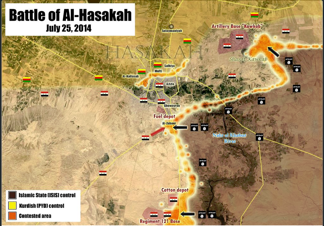
About the Div 17 Nothing confirmed at the moment the ISIS showing some soldiers beheading -> http://www.liveleak.com/view?i=113_1406258044 Here the BBC http://www.bbc.com/news/world-middle-east-28481283 but they just quoting the anti Government SOHR
Some anti government reports claim the solders trapped or at least part of them try to withdraw to Ayn Issa who is in Army control (map is in black need fixing that) http://www.syriahr.com/index.php?option=com_news&nid=21304&Itemid=2&task=displaynews#.U9JnR7EXIeA --Pototo1 (talk) 15:42, 25 July 2014 (UTC)
- According to new data IS militants attacked the military base Division 17 but did not take it. Sources said that in Raqa province, which is mainly held by IS, the jihadists attacked two positions of the army's 17th Division, sparking fighting that left dozens of dead and wounded, the Observatory said. In one attack, two suicide bombers -- one a Saudi -- blew up trucks packed with explosives. "At least six soldiers, one an officer, were decapitated and eight jihadists were killed," the Observatory said.Yahoo NewsNahatnetNOW NewsThe Daily StarAgence France-Presse Hanibal911 (talk) 16:12, 25 July 2014 (UTC)
Read the SOHR page now. It looks like they are not sure what has happened. SOHR writes: "al-Raqqa province: clashes continue around the 17th division, a regime's convoy backed up by helicopters and warplanes is moving from al-Salamia to al-Raqqa . conflicted reports about the fate of 900 regular soldiers whether if they pulled back into the 93 brigade in EIn Essa, or they are still inside the 17th division, amid air strikes on ISIS bastions inside and around the division." pro-gov source claims SAA repelled multi-wave assault killing 520 enemies. http://www.syrianperspective.com/2014/07/syrian-army-division-17-kills-520-isis-savages-in-spectacular-defensive-operation.html While other reports claim the majority of SAA have fled to base to the north. Either or both of these reports could be propaganda.
We need to wait.
ISIS fanboys claims they controlled the "Major Part" of the base http://www.liveleak.com/view?i=574_1406293578 --Pototo1 (talk) 17:54, 25 July 2014 (UTC)
First pictures published by the RMC inside division 17. , and this is the northern part
SOHR now confirmed it http://syriahr.com/index.php?option=com_news&nid=21314&Itemid=2&task=displaynews#.U9K2tfldWSp Alhanuty (talk) 19:59, 25 July 2014 (UTC)
IS claim captured the officers barracks on 17 Division the pictures but from bodies beheading are from outside of division on Raqqah city. https://www.youtube.com/watch?v=wkvDvXArzjo
- At the moment seems the attack on North East of Hasakah was repelled according official reports https://www.youtube.com/watch?v=Y4ejdKfiiiQ --Pototo1 (talk) 20:24, 25 July 2014 (UTC)
Syrian sama TV is talking about Raqqah but need a Arabic talker https://www.youtube.com/watch?v=BSu4W-bdG5w
According to this source, http://www.al-monitor.com/pulse/security/2014/07/violent-attack-syria-army-islamic-state-raqqa-hasakah.html#, both attacks on division 121 and division 17 failed.Here is another source about Division 17, http://www.aawsat.net/2014/07/article55334708 — Preceding unsigned comment added by 2602:30A:C01B:89F0:4C1F:A767:8E14:8CED (talk) 22:54, 26 July 2014 (UTC)
Most sources suggests Ayn Issa is controlled by Army
This map (probability neutral credibility low) showing Ayn Issa (July 7) under army control http://umap.openstreetmap.fr/fr/map/desyracuse-syria-civil-war-7-july-2014_12153#15/36.3836/38.8653
Pro government map (Credibility good) showing Ayn Issa under army control (July 6) https://twitter.com/PetoLucem/status/485716436678365184/photo/1
Anti government map (Credibility good) showing Ayn Issa under army control (May 5) http://sia1.subirimagenes.net/img/2014/07/25/140725074249501527.jpg
Anti government SOHR suggests the 25/7 this zone is controlled by Army too on this report https://www.syriahr.com/index.php?option=com_news&nid=21304&Itemid=2&task=displaynews#.U9JnR7EXIeA
2 sources anti government
1 Pro government
1 Neutral and same result in the 4 fourth sources suggest this place is controlled by the Army --Pototo1 (talk) 17:51, 25 July 2014 (UTC)
One more from Anti Government SHOR suggest Ayn Issa is controlled by Army http://syriahr.com/index.php?option=com_news&nid=21314&Itemid=2&task=displaynews#.U9K2tfldWSp
And pro government twitter https://twitter.com/EjmAlrai/statuses/492922372953878528 — Preceding unsigned comment added by Pototo1 (talk • contribs) 16:49, 26 July 2014 (UTC)
On Wikimapia is visible how part the Brigade 93 are part from Ayn Issa Tonw http://wikimapia.org/#lang=es&lat=36.376999&lon=38.855467&z=15&m=b
I vote for move keeping it in red — Preceding unsigned comment added by Pototo1 (talk • contribs) 18:01, 26 July 2014 (UTC)
This pro government source report the Army captured Ayn Issa in June 2013 and latter https://www.facebook.com/syria24english/posts/539393969429723 in November 2013 http://www.syriatimes.sy/index.php/news/local/6406-syrian-arab-army-imposes-control-over-raqqa-s-ayn-issa-town-advances-in-barzeh-suburb
- These Anti government sources no said that in of explicitly form the Army controlled Ayn Issa but suggests that 12
It's not enough ?
Larousse is a very hard line anti government source.........--Pototo1 (talk) 06:12, 27 July 2014 (UTC)
Kafrzita
 | It is requested that an edit be made to the semi-protected template at Template:Syrian Civil War detailed map. (edit · history · last · links · sandbox · edit sandbox · sandbox history · sandbox last edit · sandbox diff · transclusion count · protection log) This template must be followed by a complete and specific description of the request, that is, specify what text should be removed and a verbatim copy of the text that should replace it. "Please change X" is not acceptable and will be rejected; the request must be of the form "please change X to Y".
The edit may be made by any autoconfirmed user. Remember to change the |
I belive this town should go just green as the regime has no presence here since February.
Map from May , and July , I know both maps are pro-oppositin but it's quite obvious.
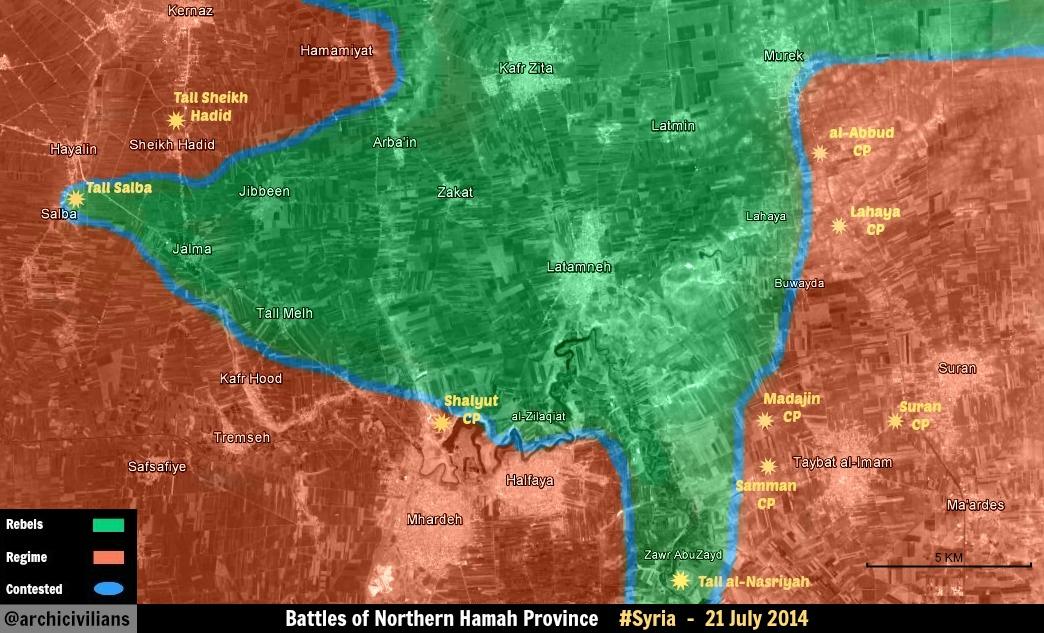
- You're going to need third party reliable source for this edit. Mlpearc (open channel) 00:24, 26 July 2014 (UTC)
Thanks for the maps but we need to have a specific source talking about that specific town or place.
Easy examples = 1 2 --Pototo1 (talk) 01:10, 26 July 2014 (UTC)
Shaer gas field
according to sohr saa capture and full control shaer gas field : http://www.syriahr.com/index.php?option=com_news&nid=21360&Itemid=2&task=displaynews — Preceding unsigned comment added by 151.250.23.28 (talk) 18:24, 26 July 2014 (UTC)
Official confirmation http://www.sana.sy/en/?p=8139 --LogFTW (talk) 18:32, 26 July 2014 (UTC)
Atshan in Hama
| It is requested that an edit be made to the semi-protected template at Template:Syrian Civil War detailed map. (edit · history · last · links · sandbox · edit sandbox · sandbox history · sandbox last edit · sandbox diff · transclusion count · protection log) This template must be followed by a complete and specific description of the request, that is, specify what text should be removed and a verbatim copy of the text that should replace it. "Please change X" is not acceptable and will be rejected; the request must be of the form "please change X to Y".
The edit may be made by any autoconfirmed user. Remember to change the |
Why don't you add Atshan city in Hama. The city should be added to the map to show a proof that rebels control the area between Mork and Atshan, or it will show that the SAA is already in south Idlib.
location: http://wikimapia.org/#lang=en&lat=35.406821&lon=36.822567&z=14&m=b
the city is under rebel held and it was attacked by chemical gas in april 2014, 3 months ago. I know the sources that shows the city under rebel held are not enough, but would help.
SyianCoalition
Muslim Brotherhood SN4HR 178.77.148.235 (talk) 18:36, 26 July 2014 (UTC)
Is against the rules used anti goverment sources to showing insurgents advances (All insurgents groups) — Preceding unsigned comment added by LogFTW (talk • contribs) 18:44, 26 July 2014 (UTC)
Hasakah city and the villages and towns between Shadadi and Hasakah city
it logically doesn't make sense that the government still controls these areas especially after IS seized the 121th regiment,also user: zenithfel brought a reliable source to confirm that http://online.wsj.com/articles/islamic-state-militants-confront-syria-forces-in-rare-confrontation-1406239224 . Alhanuty (talk) 19:01, 26 July 2014 (UTC)
Source makes no mention of the towns and villages between the two being ISIS-controlled (last reports had them government-held) and, logic or not, we can not make personal and unsourced POV edits. EkoGraf (talk) 22:44, 26 July 2014 (UTC)
According to pro-kurdish ArdaPress regime pulled out from the center of Hasakah city and YPG is now in control of the area, anyone has got sources confirming or denying? [2]
190.67.225.100 (talk) 00:40, 27 July 2014 (UTC)
Same source actually says joint patrols between the YPG and Assad forces will be conducted. In any case, we would need an independent source for this. EkoGraf (talk) 01:45, 27 July 2014 (UTC)
Kurdish Anti-PYD site Aranews has also reported the same, with additional info about 350 YPG soldiers being deployed to Melebiya regiment, which I suppose is 121:
http://aranews.net/2014/07/ypg-pro-assad-forces-enemy-enemy-friend/
In any case, yes, will have to wait for other sources, as pro-KDP sites tend to publish anything that indicates YPG-SAA cooperation regardless of veracity.
190.67.225.100 (talk) 07:27, 27 July 2014 (UTC)
Need more Sources to put the Regiment 121 in Hasakah on ISIS insurgents hands.
The anti government source used to change the map no mentioned the Regimen 121 https://www.facebook.com/syriahroe/posts/560274404080902 it's just talking about a convoy.
Some one have something more? — Preceding unsigned comment added by Pototo1 (talk • contribs) 20:01, 26 July 2014 (UTC)
IS insurgent Captured the regiment 121 confirmed by pro gov source. --Pototo1 (talk) 20:13, 26 July 2014 (UTC) https://twitter.com/PetoLucem/statuses/493038638083891200
The source is just quoting opposition sources. Other tweets from opposition report that the regiment 121 has been taken only partially. See if the fall is confirmed. Paolowalter (talk) 20:57, 26 July 2014 (UTC)
The pro-government source is quoting opposition sources. The SOHR facebook post did say ISIS managed to take control of the base, however, the original Arabic version of the report states they managed to take only part of the base with fighting continuing [4]. Due to this, for now, best course of action would be to leave red dot with black ring. EkoGraf (talk) 22:40, 26 July 2014 (UTC)
for the arabic source,this might have been before the total control,but the pro-regime source confirmed that the base fell,https://twitter.com/p_vanostaeyen/status/493110484254883841 .Alhanuty (talk) 23:00, 26 July 2014 (UTC)
There is no before, it is not up to us to speculate. SOHR Facebook is there to present English version/copies of their Arabic reports, and the original report in Arabic states clearly the base is still being contested. As for the twitter report. I thought it was agreed to only use maps via twitter, no written statements, especially ones based on propaganda images. EkoGraf (talk) 01:37, 27 July 2014 (UTC)
the pro-government source even admitted it,and now there is reports of clashes in hasakah city itself.
also if you notice the arabic report came nine hours ago https://www.facebook.com/syriahro/photos/a.10150329947968115.393926.326766683114/10152628548408115/?type=1&permPage=1 meanwhile the english report came 8 hours ago https://www.facebook.com/syriahroe/posts/560274404080902 so the english report is newer Alhanuty (talk) 02:55, 27 July 2014 (UTC)
From http://aranews.net/2014/07/ypg-pro-assad-forces-enemy-enemy-friend/ it seems that the regiment has been retaken by SAA and Kurds forces. It will be reverted to red. The same sources states that the villages al-Karama and al-Khama’el must go black. I cannot locate the former but I am changing the latter black. Paolowalter (talk) 09:52, 27 July 2014 (UTC)
http://www.dailystar.com.lb/News/Middle-East/2014/Jul-27/265274-jihadists-make-fresh-syria-advance-activists.ashx?utm_source=twitterfeed&utm_medium=twitter#axzz38cR3XJQq Actually a neutral source is reporting Regiment 121 to be under the Islamic State control, mantain Regiment 121 as black. — Preceding unsigned comment added by 201.22.81.30 (talk) 11:01, 27 July 2014 (UTC)
Additionale info from other sources (I do not how reliable) http://breakingnews.sy/en/breakingnews/28817.html; https://www.facebook.com/Syrian.Truth.en/posts/800745113277386 the last is pro-gove and talks of progress toward the regiment.
As to dailystar article, the new of aranews above is first hand and more recent. Most of the media are reporting today yesterday new. Paolowalter (talk) 11:48, 27 July 2014 (UTC)
Adar Press reports that YPG and SAA attacked IS at Qanna/Hanna 18 km south of Hasakah city, also says something about regiment 121 but can't really make it:
190.67.225.100 (talk) 17:02, 27 July 2014 (UTC)
Khitab
Why is Khitab indicated in green? Is it because of this SOHR post? SOHR SOHR is a pro-opposition source, even more heavily since its recent change of tone. It can't be used for indicating opposition advances. Kihtnu (talk) 09:01, 27 July 2014 (UTC)
Change Khattab and Rahbeh in Hama to Green: http://www.dailystar.com.lb/News/Middle-East/2014/Jul-27/265274-jihadists-make-fresh-syria-advance-activists.ashx?utm_source=twitterfeed&utm_medium=twitter#axzz38cR3XJQq
Daily Star is a neutral source and a respect newspaper. — Preceding unsigned comment added by 201.22.81.30 (talk) 10:58, 27 July 2014 (UTC)
Fuck off with your dailystar and SOHR crap. Prove it or stop posting bullshit. dailystar is anti Assad.
Regiment 121 for IS and Khitab for rebels
http://www.dailystar.com.lb/News/Middle-East/2014/Jul-27/265274-jihadists-make-fresh-syria-advance-activists.ashx#axzz38fUZ9UJn edited their topics, but they ignored this source in favor of the usual regime sources, which are random twitter guys called pro-rebel. Change those 2, as this is neutral source and Daily Star is a respect news source, and if they are quoting SOHR is because they most likely could independently verify. To change those please.
ISIS withdrew from the regiment 121 in al-Melebiya after bombardment by the pro-regime warplanes and artillery shelling by the Syrian military forces in Hasakah.Source : http://aranews.net/2014/07/ypg-pro-assad-forces-enemy-enemy-friend/ — Preceding unsigned comment added by 92.44.118.134 (talk) 18:03, 27 July 2014 (UTC)
Cite error: There are <ref group=Rara Tall Abyad> tags on this page, but the references will not show without a {{reflist|group=Rara Tall Abyad}} template (see the help page).
- ^ https://www.facebook.com/syriahroe/posts/558173150957694
- ^ http://www.adarpress.net/index.php/2013-07-29-08-54-39/3688-%D9%85%D9%8F%D8%B1%D8%A7%D8%B3%D9%84%D9%86%D8%A7-%D8%AF%D9%88%D8%B1%D9%8A%D8%A7%D8%AA-%D9%85%D9%8F%D8%B4%D8%AA%D8%B1%D9%83%D8%A9-%D8%A8%D9%8A%D9%86-ypg-%D9%88%D9%82%D9%88%D8%A7%D8%AA-%D8%A7%D9%84%D9%86%D8%B8%D8%A7%D9%85-%D9%81%D9%8A-%D8%A7%D9%84%D8%AD%D8%B3%D9%83%D8%A9%D8%8C-%D9%88%D9%84%D8%A7-%D8%A3%D8%AB%D8%B1-%D9%84%D9%84%D9%85%D9%8F%D9%82%D9%86%D9%91%D8%B9%D9%8A%D9%86-%D9%81%D9%8A-%D8%A7%D9%84%D9%85%D8%AF%D9%8A%D9%86%D8%A9?utm_source=twitterfeed&utm_medium=twitter