
Wiehle–Reston East station: Difference between revisions
Swap images; copyedits; etc |
No edit summary |
||
| Line 62: | Line 62: | ||
===Location=== |
===Location=== |
||
The station sits in the median of [[Virginia State Highway 267|SR 267]], similar to how the [[Orange Line (Washington Metro)|Orange Line]] is located in the median of [[Interstate 66]] from [[Vienna (WMATA station)|Vienna]] (the current terminus of the Orange Line) to [[East Falls Church (Washington Metro)|East Falls Church]]. The station has approximately 2,300 parking spaces to the north of the road.<ref name=wiehle>[http://www.fairfaxcounty.gov/connector/routes/dullesrail/wiehlerestoneaststation.htm Wiehle–Reston East Metro Station]</ref> The main platform has a height of {{convert|5|ft|m|abbv=on}} at its east end and {{convert|6.5|ft|m|abbv=on}} at its west end.<ref>{{cite web|url=http://www.dullesmetro.com/pdfs/DCMPStationHeights-2-18-09.docx|publisher=WMAA|title=DCMP Station Heights Actual|accessdate=2010-11-10}}</ref> |
The station sits in the median of [[Virginia State Highway 267|SR 267]], similar to how the [[Orange Line (Washington Metro)|Orange Line]] is located in the median of [[Interstate 66]] from [[Vienna (WMATA station)|Vienna]] (the current terminus of the Orange Line) to [[East Falls Church (Washington Metro)|East Falls Church]]. The station has approximately 2,300 parking spaces to the north of the road.<ref name=wiehle>[http://www.fairfaxcounty.gov/connector/routes/dullesrail/wiehlerestoneaststation.htm Wiehle–Reston East Metro Station]</ref> The main platform has a height of {{convert|5|ft|m|abbv=on}} at its east end and {{convert|6.5|ft|m|abbv=on}} at its west end.<ref>{{cite web|url=http://www.dullesmetro.com/pdfs/DCMPStationHeights-2-18-09.docx|publisher=WMAA|title=DCMP Station Heights Actual|accessdate=2010-11-10}}</ref> |
||
As of opening day, July 26, 2014, Wiehle-Reston East is the WMATA rail station located furthest from downtown Washington, D.C, 17.1 miles from [[Metro Center (WMATA station)|Metro Center station]] in straight line distance. Prior to its opening, Red Line terminus [[Shady Grove (WMATA station)|Shady Grove station]] in [[Montgomery County, Maryland]] was the most distant station from Metro Center. |
|||
====Transit-oriented development==== |
====Transit-oriented development==== |
||
Revision as of 00:07, 10 August 2014

Wiehle–Reston East (preliminary names Wiehle Avenue, Reston–Wiehle Avenue)[2][3] is a Washington Metro station in Fairfax County, Virginia on the Silver Line. It began operation on July 26, 2014,[1] and is the western terminus of the Silver Line from 2014 until around 2018,[4] when Route 772 will become the western terminus. Located in Reston, the station is being developed alongside Reston Station, a mixed-use urban center.[5]
Station layout
| G | Street Level | Exit/ Entrance |
| M | Mezzanine | One-way faregates, ticket machines, station agent |
| P Platform level |
Westbound | → ← ← |
| Island platform, doors will open on the left, right | ||
| Eastbound | → ← | |
History
Name
Wiehle (/ˈwiːliː/) in the station's name refers to nearby Wiehle Avenue, which itself is named after a small town, Wiehle's Station,[6] built in 1892 that used to be located nearby.[7][8]
Location
The station sits in the median of SR 267, similar to how the Orange Line is located in the median of Interstate 66 from Vienna (the current terminus of the Orange Line) to East Falls Church. The station has approximately 2,300 parking spaces to the north of the road.[9] The main platform has a height of 5 feet (1.5 m)* at its east end and 6.5 feet (2.0 m)* at its west end.[10]
As of opening day, July 26, 2014, Wiehle-Reston East is the WMATA rail station located furthest from downtown Washington, D.C, 17.1 miles from Metro Center station in straight line distance. Prior to its opening, Red Line terminus Shady Grove station in Montgomery County, Maryland was the most distant station from Metro Center.
Transit-oriented development
In order to foster high density development within walking distance of the station, Fairfax County has awarded development rights to an existing nine acre park-and-ride lot on the station site. Reston-based Comstock Partners constructed a 2,300 space below-ground parking structure as well as 1,500,000 square feet (140,000 m2) of commercial and residential space, consisting of more than 500,000 square feet of Class A office space, approximately 100,000 square feet of restaurants, shops, and service-oriented retailers, a 200-plus room hotel, and approximately 900 luxury residences.[11]
Station facilities
- 2 station entrances (both sides of SR 267)
- Pedestrian bridge crossing SR 267
- Bus dropoff/pickup (both entrances)
- Kiss & Ride (north side only)
- Secure bike storage room
- Parking for 2,300 cars (north side)
Gallery
-
 Passengers await the arrival of the second Silver Line train from Wiehle – Reston East on its first day of service
 -
 The station under construction in July 2013
 -
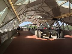 Inside the mezzanine
 -
 Trains reverse directions on the tail tracks west of the station

.jpg)


References
- ^ a b "Completion date on Silver Line pushed back again". WTOP. Retrieved December 8, 2013.
- ^ "Board of Supervisors Approves Proposed Silver Line Station Names". April 10, 2012. Retrieved April 11, 2012.
- ^ Hosh, Kafia (March 29, 2011). "Fairfax OKs names for new Metrorail stations". Washington Post. Retrieved March 29, 2011.
- ^ Dulles Metro Front Page
- ^ MacGillis, Alec (February 16, 2006). "County Picks Project for Wiehle Avenue Site; Reston Firm Proposes Substantial Mixed-Use Development on Nine-Acre Park-and-Ride Lot". The Washington Post. p. FE03.
- ^ "Max C.J. Wiehle". The Washington Post. Aug 30, 1956. p. 34.
- ^ MacDonald, Gregg (March 30, 2012). "Wiehle legacy lives on in Reston". Fairfax Times.
- ^ Rosenfeld, Megan (June 13, 1975). "Reston Group Would Revive Extinct Town: Restonites Trying To Revive Wiehle". The Washington Post. p. C1.
- ^ Wiehle–Reston East Metro Station
- ^ "DCMP Station Heights Actual". WMAA. Retrieved 2010-11-10.
- ^ MacGillis, Alec (2006-02-16). "Project Chosen for Site at Planned Metro Stop in Reston". Washington Post. p. LZ03. Retrieved 2009-12-19.