Kerakat: Difference between revisions
Bond.bagesh (talk | contribs) Tags: Mobile edit Mobile app edit |
|||
| Line 87: | Line 87: | ||
*Brahmanpur |
*Brahmanpur |
||
*Jhamaka |
*Jhamaka |
||
*Chaura |
|||
*Chaur |
|||
*Chhitaona |
*Chhitaona |
||
*Dill ka pura |
*Dill ka pura |
||
Revision as of 22:33, 18 October 2014
Kerakat
Kerakat | |
|---|---|
city | |
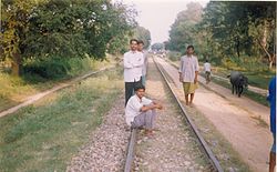
 Railway tracks in Murlipur Dagra, Kerakat | |
| Nickname: KKT | |
| Country | |
| State | Uttar Pradesh |
| District | Jaunpur |
| Area | |
| • Total | 5 km2 (2 sq mi) |
| Population (2001) | |
| • Total | 12,472 |
| • Density | 2,500/km2 (6,500/sq mi) |
| Languages | |
| • Official | Hindi |
| Time zone | UTC+5:30 (IST) |
| Vehicle registration | UP62 |
Kerakat is famous Tahseel and town of Dist.Jaunpur.it is situated near by Gomati River which also makes its land very fertile. It is located in the List of districts of India as Jaunpur, Uttar Pradesh it is very well connected via road by Azamgarh, Jaunpur and Varanasi. Varanasi Airport (Sri Lal Bahadur Shastri Airport) is at 30 km distance. It is well connected through Rail link via Audhiar-Jaunpur and Jalalganj(JLL) Railway station connect to Lucknow. Thanks to Railway ministry who have shifted KKT Railway station to Muftiganj and DHOBHI (a nearby village of KKT) nowadays the narrow gauge rail track is replaced with broad gauge. Historical place: many temple as Kali Mata Mandir. Gomteshwar Mahadev near the Shihauli is situated on the coast of Gomti river,'Handiya Baba dev smarak' Khalishpur(khurd).Kerakat is known for its own activities throughout India.
List of villages in Kerakat
- ailiya
Ajorpur
- Akbarpur
- Amhit
- Atraura
- Auri
- Bambawan
- Bantari
- Baraichha
- Baraichhabir
- Baraie
- Baramanpur
- Baswari
- Behara
- Belhari
- Bhainsa
- Bhairo
- Bhanpur
- Bhaura
- Bhitari
- Brahmanpur
- Jhamaka
- Chaura
- Chhitaona
- Dill ka pura
- Deduwana
- Dehari
- Deorai
- Dharaura
- Gaushpur
- Maniyara
- Ghurdaur,
- Gobra
- Gulara
- Hurhuri
- Jamua
- Kerakat
- Khalispur(Khurd)
- Kharagsenpur
- Khargasipur
- Kusaila
- Kusarna
- LAKTHEPUR
- Luttipur
- Murlipur
- Murki
- Nalapr
- Narhan
- Naupur
- Nihalapur
- Nuaaw
- Nonmatiyan { नोनमटीयां }
- Pachwar
- Parapati
- Parmanandpur
- Puranpur
- Parauganj
- Ramgarh
- Rampur
- Bharehari
- Ratnupur
- Sahabuddinpur
- Saraibiru
- Sarauni
- Paschhim
- Patti
- Sarauni Purab Patti
- Saroj
- Barewar
- Senapur
- Shivram Pur Khurd
- Sihauli
- Sijhwara
- Sohani
- Sultanpur
- Tadwa
- Tariyari
- Tejpur
- Thana Gaddi
- Udaichandpur
- Umarwar
Demographics
As of 2001[update] India census,[1] Kerakat post had a population of around 5 lakhs. Males constitute 52% of the population and females 48%. Kerakat has an average literacy rate of 70%, higher than the national average of 59.5%: male literacy is 75%, and female literacy is 62%. In Kerakat, 17% of the population is under 6 years of age.
References
- ^ "Census of India 2001: Data from the 2001 Census, including cities, villages and towns (Provisional)". Census Commission of India. Archived from the original on 2004-06-16. Retrieved 2008-11-01.
External links
