
Talk:Control of cities during the Syrian civil war: Difference between revisions
| Line 452: | Line 452: | ||
https://www.youtube.com/watch?v=N-PIbV01LjQ&feature=youtu.be |
https://www.youtube.com/watch?v=N-PIbV01LjQ&feature=youtu.be |
||
This map should be updated. |
This map should be updated because it's getting funny now. |
||
Revision as of 11:26, 8 February 2015
| This is the talk page for discussing improvements to the Control of cities during the Syrian civil war article. This is not a forum for general discussion of the article's subject. |
Article policies
|
| Find sources: Google (books · news · scholar · free images · WP refs) · FENS · JSTOR · TWL |
| This page is not a forum for general discussion about Control of cities during the Syrian civil war. Any such comments may be removed or refactored. Please limit discussion to improvement of this article. You may wish to ask factual questions about Control of cities during the Syrian civil war at the Reference desk. |
| This article is of interest to the following WikiProjects: | |||||||||||||||||||||||||||||||||||||||||||||
| |||||||||||||||||||||||||||||||||||||||||||||


.svg)
| To help centralise discussions and keep related topics together, Template talk:Syrian Civil War detailed map redirects here. |
Template:Syrian Civil War sanctions
|
Index 1, 2, 3, 4, 5, 6, 7, 8, 9, 10 |
|
This page has archives. Sections older than 7 days may be automatically archived by Lowercase sigmabot III when more than 3 sections are present. |
Kafrlata - Idlib
I think it is rebel held since it explains how the attacks in Ariha were orchestrated. Here a pro-regime page describing every detail of the attack on Ariha said the rebels were defeated and retreated back to Kafrlata [1]. And we have numerous accounts of shelling on Kafrlata so I really doubt it is contested. Can my fellow editors provide me with sources saying otherwise? ChrissCh94 (talk) 17:29, 30 January 2015 (UTC)
There is a misunderstanding here. Rebels did not attack Ariha town. Their main objective (announced on IF channels) was to capture the mountain part that overlooks Ariha (in that case Al Fanar checkpoint too). Groups in this offensive :
- Mainly Islamic Front (Suqur Sham, Faylaq Sham) supported by
- FSA (Liwa Haq, 13th Division) and
- Al Nusra (even thought i haven't seen them)
- Here SOHR source says that rebels advanced on the mountain on al-Baradat building complex, which includes Al Fanar checkpoint. They also said that rebels destroyed a regime vehicle in Mastomah, and here is the proof FSA 13th division destroying shilka in Mastomah.
- On this source SOHR2 also said that rebels advanced on the mountain and detonated a tunel bomb in Al Fanar complex. Here is the proof, Islamic Front detonating the bomb.
- Now some pro-opposition sources. Islamic front shooting mortars from Kafr Lata here and here2 .. Suqur Sham (IF) commander giving moral speech in Kafr Lata before the offensive.
−Now I'm 100% sure that rebels took Al Fanar because it's located right in the start of the mountain, and if SOHR says that rebels advances there, it means it's not possible to advance while avoiding this checkpoint.
- This video shows rebels overlooking the town of Ariha.
- This video shows Al Fanar checkpoint and FSA (Liwa Haqq) members just passing by it. Kafr Lata should definately be changed, I'm not sure for Al Fanar but i want other opinions. DuckZz (talk) 23:11, 30 January 2015 (UTC)
- Yes, so confident, yet SOHR did not trumpet this "glorious" victory...interesting. The rebel offensive has failed [again] http://www.almasdarnews.com/article/idlib-syrian-army-reaffirms-full-control-areeha/ XJ-0461 v2 (talk) 00:40, 31 January 2015 (UTC)
If rebels gained areas around the town, not even trying to attack Ariha, not even in plans. What is the best thing a pro-Government editor (2 times banned user from twitter) can write ? "SAA, NDF recaptured Ariha" haha facepalm really...DuckZz (talk) 00:46, 31 January 2015 (UTC)
Congrats, the SAA/NDF advanced in the area they already controlled. Al-Masdar so reliable, haha. The rebels never attacked Ariha, and now they retake Ariha. Next thing we will see is SAA retaking Homs or Qusayr, lol, they are so desesperate for wins they make-up advances in towns they hold already. — Preceding unsigned comment added by 200.219.152.90 (talk) 01:59, 31 January 2015 (UTC)
"haha facepalm really" Is this supposed to be a coherent sentence, because it is not. Also, the article referred to the Ariha area [locations such as Jabal al arba'een] being retaken, not the town itself [you would have known that if you read more than just the title]. Also, the fact that you are tracking the editor is just sort of weird. XJ-0461 v2 (talk) 02:57, 31 January 2015 (UTC)
- I gotta say DuckZz you are becoming way too biased. To be fair, except for the Southern Front, the rebels are indeed losing the war and infighting has triumphed among them. In 2013 they controlled more than half the country while now they only control rural Aleppo and Daraa. Sadly the war is headed towards a bloody stalemate where every party will make gains and consolidate them in areas of strength while losing the less important ones. Not to forget the rise of the jihadis. ChrissCh94 (talk) 09:12, 31 January 2015 (UTC)
CnrissCh94 .I agree Kafrlata is rebel controlled .Pyphon (talk) 12:35, 31 January 2015 (UTC)pyphon
ChrissCh94 I don't understand why you think like that. Rebels will lose that's for sure, but it'll take a while. I support the Syrian army (SAA) against rebels but i also support FSA rebels against NDF army, nobody can really hate me because of this. DuckZz (talk) 16:32, 31 January 2015 (UTC)
- It's just you oppose everything regime related. Everyone is entitled to an opinion but it must not interfere with our work. Nobody here hates you! Cheers mate. ChrissCh94 (talk) 18:05, 31 January 2015 (UTC)
the rebel advance in Southern Syria will define the conclusion of the war.Alhanuty (talk) 20:19, 31 January 2015 (UTC)
- What do you mean? XJ-0461 v2 (talk) 20:55, 31 January 2015 (UTC)
- Correction: The outcome of the battle of Aleppo will define the outcome of the war. Hint 2012: Rebels were winning in Aleppo and in all of Syria while in 2014: rebels are losing in Aleppo and in all of Syria. ChrissCh94 (talk) 23:30, 1 February 2015 (UTC)
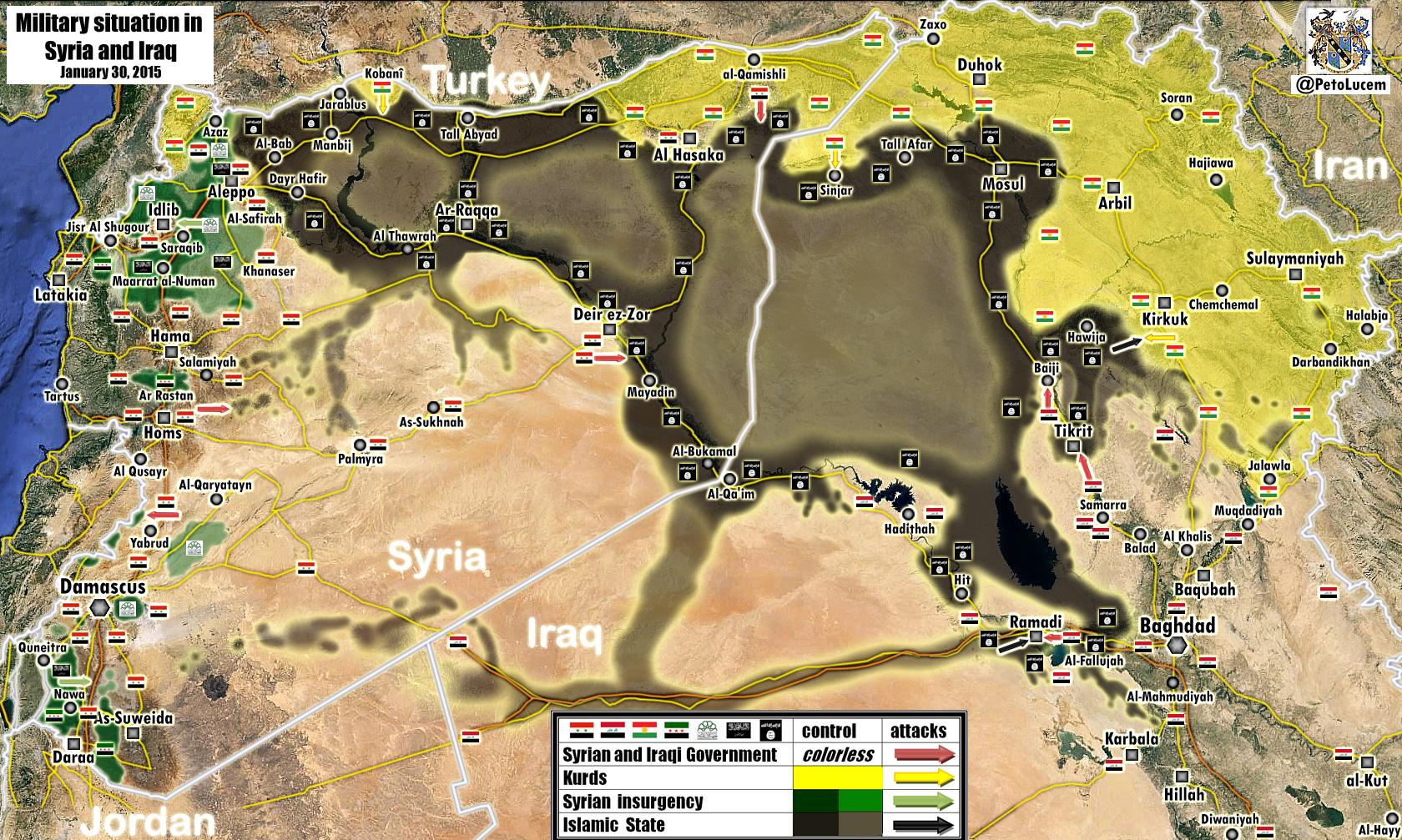
Peto Lucem General Map 30/1/2015
Here is https://pbs.twimg.com/media/B8n1Y6vCAAAh42A.jpg:large Peto Lucem Maps are very 99,99% correct most times
- It's Al-Masdar Map.here.Nice try,but Al-Masdar and Peto Lucem are pro-regime sources and we cant use them.Lindi29 (talk) 14:25, 31 January 2015 (UTC)
True. Both Al-Masdar and SOHR are unreliable in my opinion. Only use Al-Masdar to rebel advances, and SOHR for regime advances.
- What are you talking about Lindi? PetoLucem and Masdar have nothing to do with each other. Leith Fadel, the person behind al-Masdar uses his map, but they're are not the same person. Peto Lucem maps together with DeSyracuse's map have been some of the most precise maps during this conflict. While I agree that PetoLucem is a bit pro regime and DeSyracuse is a bit pro rebel.
- PetoLucem maps are NOT from al-Masdar, he (leith Fadel) simply uses the same maps Peto publishes on Twitter. Stop spreading lies. Masdar is fairly pro regime but the maps he uses are made by PetoLucem, not himself.MesmerMe (talk) 15:45, 31 January 2015 (UTC)
As far as I can tell, this map is fairly consistent with the one we have here. Only major difference is in Deir-Ez-Zor, where Peto has given the southern half to the SAA, whereas we have it as under ISIS control. That part of the governate is fairly empty anyway [only things we have listed in it as Shulah and Kabajeb], so the discrepancy is of no consequence. XJ-0461 v2 (talk) 19:36, 31 January 2015 (UTC)
XJ-0461 v2 .I agree Peto Lucem maps are always like ours and Lindi29 what do you mean (nice try )nobody was asking to change our map in line with his .Pyphon (talk) 19:52, 31 January 2015 (UTC)pyphon
The map is just very correct it showing the reality in the ground, Peto's Maps are always right.
Lucem always exagerates regime held territory. Aleppo specially, they had the Owaija District under SAA control for example. Now the rebels recaptured Breij area, and not a SINGLE source reported the rebels to have recaptured the Owaija District, but it is obvious they had to be there in other to reach Breij.
- Not really. And they did not recapture the Breij area. What source said that? XJ-0461 v2 (talk) 17:58, 1 February 2015 (UTC)
Zabadani & rest
According to IvanSidorenko and his pro-government sources here2, the SAA (and company) are aiming to capture Zabadani (already contested), Madaya, Serghaya and Yabous. What others think ? DuckZz (talk) 16:46, 1 February 2015 (UTC)
- That is interesting. Madaya and Serghaya were confirmed to be SAA held by Al-Monitor a long time ago. I am not aware of any rebel counter offensives in the area [which would place them back in rebel hands since then]. We really should not change anything with Zabadani since it is already contested and SOHR confirms SAA checkpoints in the town. As for Yabous, I have no news on that. I would say for now, green rings on all the towns you mentioned, and if you can find a corroborating source, we can take further action. XJ-0461 v2 (talk) 18:01, 1 February 2015 (UTC)
deSyracuse map shows Serghaya as contested. The map is 20 days old so maybe rebels do have control of those towns but now facing clashes with SAA & Hezbolah. I belive that IvanSidorenko is a bit pro-government oriented and not biased. Maybe Madaya should go contested since it's right next to Zabadani and SOHR reported barel bomb attacks on it's western outskirts DuckZz (talk) 18:25, 1 February 2015 (UTC)
- DuckZzPro opposition source showed that area wher located Madaya, Serghaya under control by army.here Also Ivan Sidorenko it is not pro government source and also deSyracuse map it is pro opposition source which we cant use to display success by rebels. Also previously biased a pro-opposition source clear showed that Serghaya under control by army.here Hanibal911 (talk) 19:25, 1 February 2015 (UTC)
- Also earlier some reliable sources reported that Serghaya under control by army. This issue has already been discussed previously. Hanibal911 (talk) 19:34, 1 February 2015 (UTC)
- We did agree earlier that Madaya was contested.. Serghaya is under local NDF control. ChrissCh94 (talk) 23:10, 1 February 2015 (UTC)
- Pro opposition source showed that area wher located Kafr Yabous under control by Syrian troops and Hezbollah.here Hanibal911 (talk) 09:02, 2 February 2015 (UTC)
- We did agree earlier that Madaya was contested.. Serghaya is under local NDF control. ChrissCh94 (talk) 23:10, 1 February 2015 (UTC)
- Also earlier some reliable sources reported that Serghaya under control by army. This issue has already been discussed previously. Hanibal911 (talk) 19:34, 1 February 2015 (UTC)
Hanibal911 .ChrisCh94 . Why is Madaya gone green? Pyphon (talk) 09:57, 2 February 2015 (UTC)pyphon
- PyphonPro gov. source reported that Madaya rebel-held but besieged by army and allies and Zabadani contested.here And SOHR also confirmed that city Zabadani for now contested and army present inside city.SOHR Hanibal911 (talk) 10:22, 2 February 2015 (UTC)
Hanibal911 .Thankyou good work .Pyphon (talk) 10:32, 2 February 2015 (UTC)pyphon
SAA advances in Hasakah
SAA has advanced southeast of Hasakah city and captured two villages, confirmed by SOHR [2]. But no names are stated. Would be good to try and find out which ones they are. EkoGraf (talk) 21:04, 1 February 2015 (UTC)
- There is info for Ivan Sidorenko [3] about 5 village and their name. Abu Saad / Khchwet / Aldaudih / sera / Rhqra (217.99.81.204 (talk) 21:21, 1 February 2015 (UTC))
- Al-Masdar talks about them here: http://www.almasdarnews.com/article/syrian-army-liberates-5-villages-rural-al-hasakah/ XJ-0461 v2 (talk) 22:57, 1 February 2015 (UTC)
- We should see which two of the five are closest to the fronltine and in a south-eastern direction so those two are most likely the ones they captured per SOHR. EkoGraf (talk) 23:00, 1 February 2015 (UTC)
SAA Advances in Hasakah - Deir Ez Zoor - Rif Dimashq
SAA have advanced on multiple fronts via SOHR [4] [5] [6] I hope the editors make the correct changes. ChrissCh94 (talk) 23:19, 1 February 2015 (UTC)
- Why is Kfar Yabous JAN-held? ChrissCh94 (talk) 23:20, 1 February 2015 (UTC)
- According to this map by Desyracuse,[7] it is SAA held. I will change it. XJ-0461 v2 (talk) 00:47, 2 February 2015 (UTC)
- We also agreed to change Madaya to contested earlier in this talk page. In addition, here's a pro-gov source showing it as opp-held [8] ChrissCh94 (talk) 01:47, 2 February 2015 (UTC)
- Why is Kfar Yabous another time to JAN-held? Yesterday it was grey, next red and today is grey.(83.26.97.125 (talk) 16:19, 2 February 2015 (UTC))
- We also agreed to change Madaya to contested earlier in this talk page. In addition, here's a pro-gov source showing it as opp-held [8] ChrissCh94 (talk) 01:47, 2 February 2015 (UTC)
- According to this map by Desyracuse,[7] it is SAA held. I will change it. XJ-0461 v2 (talk) 00:47, 2 February 2015 (UTC)
Qamishlo
Please change the icon of qamishlo kurds controll more than 85% Of qamishlo yet it looks like assad controlls 90% of qamishli judging by the amount of red on the icon/mark.
- Source? XJ-0461 v2 (talk) 00:47, 2 February 2015 (UTC)
What does asad controll except the bordergate & the small city centre?
XJ-0461 You don´t need any source to put the rings in different order (yellow-red-yellow).Rhocagil (talk) 04:26, 2 February 2015 (UTC)
- In order to change the city from a regime majority control to Kurdish majority control [which is what he wants], you need a source. On a side note, if the order of the rings were to be changed, It would show that the kurds control the city center, which they do not [unless a source is provided to the contrary]. XJ-0461 v2 (talk) 05:00, 2 February 2015 (UTC)
- Pro oppositio source here clearly shows that the city is divided almost in half, and the army located is inside the city and around it. So that for now city marked correct. Also Rhocagil you should know that we can not change the card without specifying the source. Hanibal911 (talk) 08:55, 2 February 2015 (UTC)
XJ-0461 v2 I don´t think that kind of argument is valid. Do you think that SAA is in control of the city centers in Al-Dumayr, Ar-Ruhaybah and Al Wa´ar or FSA in Khan Shaykhun? No this is not an argument and this is not the question. The three circle mark is just a mark, but in the case of Qamishlo it looks wrong. I suggest the three mark circle should be changed to (yellow-red-yellow). And Hanibal911 if you want a source, just use the one that you just provided. Even thou I believe is slightly wrong it´s still obvious that majority of the city area is under kurd control. Rhocagil (talk) 21:15, 2 February 2015 (UTC)
- The source he provided showed 50/50 control [orange in the middle is SAA held according to other sources], no Kurdish majority. To debate that ring configurations would at this point simply be a matter of aesthetics, so it should be left as is unless another source is provided. XJ-0461 v2 (talk) 22:38, 2 February 2015 (UTC)
- RhocagilOn this map here the areas in city Qamashli which marked in red it is territory which under control by Syrian troops and areas which marked in yellow it is territory which under control by YPG and areas which marked in orange it is territory which jointly controlled between Syrian troops and YPG. Hanibal911 (talk) 08:21, 3 February 2015 (UTC)
Kurdish presence in alleppo
source https://twitter.com/sergermed/status/561985092890144768
https://twitter.com/sergermed/status/560952310776750080
https://twitter.com/sergermed/status/560576534407565312
same account have also mentioned about kurds+fsa rebels in Qazel, Ghara/Yani yaban, Dalhah & Baghirin these villages aren't even marked in this map.
YPG in KOBANE
According to this confirmed source YPG controlls zorava tel aotk korabi and susan are they even marked on the map?
https://twitter.com/ColdKurd/status/561294811094065153
Joum Ali in kobane.
Joum ali in kobane
https://twitter.com/jackshahine/status/561974858951950336?lang=sv
It's completelly liberated why does the map show ISIS presence?
Al-Dalli Daraa
Al-Dalli to contested per:
http://www.almasdarnews.com/article/daraa-syrian-army-attempts-counter-rebels-battalion-82/
"The Southern Front Brigades of the Free Syrian Army (FSA) continued their offensive at the village of Dilli north of Sheikh Miskeen, bombarding the 5th Division near the southwest sector and gaining ground in the direction of the village-center." — Preceding unsigned comment added by 84.24.43.183 (talk) 08:50, 2 February 2015 (UTC)
Agree Dalli is contested .Pyphon (talk) 08:55, 2 February 2015 (UTC)pyphon
Newly liberated villages in Kobane
till-Hajb ,Tayri ,karab-kurd , jilak liberated https://twitter.com/ColdKurd/status/562279177546891264
- Let's wait some more sources or some pictures to confirm that YPG is really inside those villages. Sheran town has been marked as Kurdish controlled since 5 days ago, but actually it was liberated by YPG only last night. https://twitter.com/jackshahine/status/562232838133919744 The same source (Jack Shahine) posted a picture of Aydiq village here: https://twitter.com/jackshahine/status/562274741936209920 .in the southern front, but I have yet to see a picture of Rubi. --8fra0 (talk) 17:33, 2 February 2015 (UTC)
- 7 more villages liberated last night: Xerabnas (Qaramogh), Satiyah, Qabajigh (Qarajokh), Tashli Huyuk (Tashluk), Mojek, Bir Arab, Bishalti. This is reflected in dozens of sources: http://www.lebanon24.com/mobile/details/1002615 http://www.lebfeed.com/%D9%88%D8%AD%D8%AF%D8%A7%D8%AA-%D8%AD%D9%85%D8%A7%D9%8A%D8%A9-%D8%A7%D9%84%D8%B4%D8%B9%D8%A8-%D8%AA%D8%B3%D9%8A%D8%B7%D8%B1-%D8%B9%D9%84%D9%89-%D9%82%D8%B1%D9%89-%D9%82%D8%A8%D8%A7%D8%AC%D8%BA-%D9%88/ http://www.alahednews.com.lb/fastnews/253822/-%D8%A7%D9%84%D9%88%D8%AD%D8%AF%D8%A7%D8%AA-%D8%A7%D9%84%D9%83%D8%B1%D8%AF%D9%8A%D8%A9-%D8%AA%D8%B3%D9%8A%D8%B7%D8%B1-%D8%B9%D9%84%D9%89-%D9%82%D8%B1%D9%89-%D9%82%D8%A8%D8%A7%D8%AC%D8%BA-%D9%88%D8%B7%D8%A7%D8%B4%D9%84%D9%88%D9%83-%D9%88%D9%82%D8%B1%D9%85%D9%88%D8%BA-%D9%88-%D8%B3%D8%AA%D9%8A-%D9%88-%D9%85%D9%88%D8%AC%D9%83-%D9%88-%D8%A8%D9%8A%D8%B1%D8%B9%D8%B1%D8%A8#.VNHxy2jF870 http://slabnews.com/article/158887/ http://www.masdark.com/arabic/304311.html
- I think that we can change them. On the other hand, Tel Ghazal is still contested: https://twitter.com/jackshahine/status/563117893823774721 --8fra0 (talk) 23:41, 4 February 2015 (UTC)
- 7 more villages liberated last night: Xerabnas (Qaramogh), Satiyah, Qabajigh (Qarajokh), Tashli Huyuk (Tashluk), Mojek, Bir Arab, Bishalti. This is reflected in dozens of sources: http://www.lebanon24.com/mobile/details/1002615 http://www.lebfeed.com/%D9%88%D8%AD%D8%AF%D8%A7%D8%AA-%D8%AD%D9%85%D8%A7%D9%8A%D8%A9-%D8%A7%D9%84%D8%B4%D8%B9%D8%A8-%D8%AA%D8%B3%D9%8A%D8%B7%D8%B1-%D8%B9%D9%84%D9%89-%D9%82%D8%B1%D9%89-%D9%82%D8%A8%D8%A7%D8%AC%D8%BA-%D9%88/ http://www.alahednews.com.lb/fastnews/253822/-%D8%A7%D9%84%D9%88%D8%AD%D8%AF%D8%A7%D8%AA-%D8%A7%D9%84%D9%83%D8%B1%D8%AF%D9%8A%D8%A9-%D8%AA%D8%B3%D9%8A%D8%B7%D8%B1-%D8%B9%D9%84%D9%89-%D9%82%D8%B1%D9%89-%D9%82%D8%A8%D8%A7%D8%AC%D8%BA-%D9%88%D8%B7%D8%A7%D8%B4%D9%84%D9%88%D9%83-%D9%88%D9%82%D8%B1%D9%85%D9%88%D8%BA-%D9%88-%D8%B3%D8%AA%D9%8A-%D9%88-%D9%85%D9%88%D8%AC%D9%83-%D9%88-%D8%A8%D9%8A%D8%B1%D8%B9%D8%B1%D8%A8#.VNHxy2jF870 http://slabnews.com/article/158887/ http://www.masdark.com/arabic/304311.html
8fra0 when you were editing Kobane region (Tel Ghazal), did you accidentally edit Tall Ghazal in Hasakah to contested? Anyway you are better with editing the map then me so could you please change Tall Ghazal to Kurd held. I didn´t see any source for Tall Ghazal anywhere. Rhocagil (talk) 01:45, 5 February 2015 (UTC)
- I edited the wrong Tel Ghazal, sorry. --8fra0 (talk) 11:11, 5 February 2015 (UTC)
New sources say that Tal Ghazal, Makhraj, Khazinah, Dibrak and other villages are in YPG hands: https://twitter.com/jackshahine/status/563372401409667072 This source has proved to be very reliable in the past days. Maybe Rubi and Tafshu are still in IS control as there is no evidence of clashes there, they should be edited I think. — Preceding unsigned comment added by 8fra0 (talk • contribs) 16:31, 5 February 2015 (UTC)
Also Rubi is under YPG control according to https://twitter.com/m22bali/status/563420727626723328 --8fra0 (talk) 19:48, 5 February 2015 (UTC)
And Rubi silos also in YPG control, Tafshu village liberated by FSA and YPG jointly according to https://twitter.com/jackshahine/status/563456403059515392 and https://twitter.com/arabthomness/status/563452316117135364 --8fra0 (talk) 22:02, 5 February 2015 (UTC)
New reports of Selib, Dikmatash and Kor Ali under YPG control in Kobane western front: https://twitter.com/arabthomness/status/563749990183763969 --8fra0 (talk) 17:33, 6 February 2015 (UTC)
Yabous
Someone changed "Yabous" next to the Lebanon-damascus crossing to be held by JAN. According to Al Akhbar already gov forces have pushed all JAN rebels out of Yabous and Kfar Yabous after they briefly raided these towns a few days back. See here: http://english.al-akhbar.com/node/23507 — Preceding unsigned comment added by 169.231.27.226 (talk) 22:41, 2 February 2015 (UTC)
- Then why is Kfayr Yabous JAN-Held? ChrissCh94 (talk) 00:55, 3 February 2015 (UTC)
- because a majority of the people who edit this map are pro-rebel and don't have a neutral stance where they just use facts to mark the map. — Preceding unsigned comment added by 169.231.26.157 (talk) 16:30, 3 February 2015 (UTC)
- You know what to do ChrissCh94 =).200.48.214.19 (talk) 16:45, 5 February 2015 (UTC)
Clashes reported by SANA
There are several clashes reported by SANA and quoted by Al-manar and some other news outlets but these villages/towns are not marked as contested on the map. al-Manar and SANA also point out they targeted ISIS in Palmyra so i suggest there is isis presence in Palmyra.
Here are the villages/towns summed up: Homs: Eidon(inside al-Rastan), Deir Ful, Ghantu, Rahoum (Rahhoum) Hamah: ISIS presence in Palmyra Latakia: Ghanima Idlib: Kafr Lata (Kafr Latah) Daraa: Sheikh maskin, Jasim, Inkhel (Inkhil)
sources: http://www.sana.sy/en/?p=27257 http://www.almanar.com.lb/english/adetails.php?fromval=1&cid=23&frid=23&eid=193620 http://syriatimes.sy/index.php/news/local/16483-syrian-arab-army-kills-23-terrorists-plus-chechen-tunisian-moroccan-mercenaries-linked-to-al-nusra-front-outside-hama-and-lattakia
Spenk01 (talk) 23:50, 2 February 2015 (UTC)
- Spenk01 Source al manar made a mistake in the message. Here is the original of this message from government source SANA: Army units eliminated 23 terrorists in Hamadi Omar in Hama countryside and destroyed their weapons and ammo, in addition to destroying a cache of rockets in Mkaiman al-Shamali, leaving several terrorists dead or injured.SANA Just sometimes when the source publishes data from SANA he makes mistakes. Also city of Palmyra located in the Homs province. Hanibal911 (talk) 08:03, 3 February 2015 (UTC)
- Spenk01 Also dont need to cheat that SANS said that ISIS presence inside city Palmyra. Dont need manipulation of facts. Hanibal911 (talk) 08:11, 3 February 2015 (UTC)
- Hanibal911 Seems like i was mistaken by saying SANA was talking about ISIS presence in Palmyra. But how about the clashes SANA reported are these not credible enough to be taken in the map? Spenk01 (talk) 21:46, 3 February 2015 (UTC)
- Spenk01 Also dont need to cheat that SANS said that ISIS presence inside city Palmyra. Dont need manipulation of facts. Hanibal911 (talk) 08:11, 3 February 2015 (UTC)
Syria
Who controls the territory of Syria:
- 1) Syrian government currently controls around 50 percent of the territory, but it rules between 55 and 72 percent of the population left inside Syria.
- 2) The rebels (Including ISIS and Al Nusra} control 45 percent of the territory and 17–34 percent of the population.
- Islamic State (ISIS) It currently controls around 30 percent of Syria’s territory. The population under the Islamic State’s rule can be estimated at between 2 million and 3.5 million people, which translates into something like 10–20 percent of Syria’s current population.
- The groups like Ahrar al-Sham, the Nusra Front, the Islam Army, and the various FSA factions, we arrive at perhaps 15 percent of the territory and between 1 million and 2.5 million people, although political control remains divided among or shared by many different groups.
- 3}Kurds control no more than 5 percent of the territory with 5–10 percent of the population.Carnegie Endowment Hanibal911 (talk) 11:59, 3 February 2015 (UTC)
Eastern Homs
I am raising this issue beacause there is a big vacum on the Eastren Homs and is not showing clearly where the frontilne between SSA and Isis is but news said that SSA just captured Khattab and some other villages from Isis on this area but still it is not showing the frontline,yesterday i added some other places near the villages that SSA has just captured beacause it's logical that there is the frontline and that SSA will continue his offenisve on this places but my edit was reverted beacause I didn't have any source,I want that a consenus for this places to be reached so i am suggesting to add more places to show where the the frontline between SSA and Isis.Hanibal911,ChrissCh94,Boredwhytekid,André437,Spenk01,Alhanuty,EkoGraf,DuckZz,Tradedia,Pyphon,Rhocagil,XJ-0461 v2.Can i have your opinions?Lindi29 (talk) 13:29, 3 February 2015 (UTC)
- Problem is this front lacks sources. Part of the problem is that the area is considered remote even by Syrian standards. Most of the villages consist of hundreds of citizens at most. SAA is barely engaged there, providing artillery and logistical support for the NDF. My vote is that we add places that were captured by either side. For example ISIS captured a village, we add this village as ISIS-held. But I don't think we should go over and add the remaining random villages since we barely know who controls what. ChrissCh94 (talk) 17:30, 3 February 2015 (UTC)
- I agree with ChrissCh94 foe now we do not have data which can clearly say who control this villages. Also i think that we cant be contrary to the accepted rules of editing and add to the map a villages or city without a source who could confirm such actions. We can not be sure that the villages that we add under control of ISIS or army. My personal opinion is that we should not break the rules of editing. We have previously struggled with editors which add on map the villages without sources and some editors was blocked. So that guys we should not repeat of their actions. Hanibal911 (talk) 17:43, 3 February 2015 (UTC)
Agree with Hanibal911 and ChrisCh94 it would be difficult to show which village was under control and on our map you can almost make out the frontline of the situation as it stands .The ISIS seems to be in trouble at this time losing ground on many fronts with reports of fighters leaving for Turkey .Pyphon (talk) 09:08, 4 February 2015 (UTC)pyphon
- I'm not up to date on the area, but I agree with others that we should not make changes without sources.
- Also, there is no stable "front line" in the sense of ww1 trench warfare. Rather, there are points of control (such as checkpoints). All sides are able to at least temporarily infiltrate between points of control of an opposing side. (That is partly how the kurds were able to defeat Daesh in Kobane city : by infiltrating and ambushing Daesh fighters.)
- In some areas, such as in sieges, control points are close enough that infiltration is much more difficult. But no side has enough forces to do that everywhere. Even a million soldiers wouldn't be enough for an area as large as Syria. André437 (talk) 10:14, 4 February 2015 (UTC)
Well as much as I like a more clear frontline. I tend to agree with above statements. Lindi29 maybe you can mail SOHR and ask them if they (he) have some information that could clarify the situation. Give the regards from us other in the wiki discussion group. Rhocagil (talk) 16:19, 4 February 2015 (UTC)
Al Hirak Daraa
Hello everybody,
Several weeks ago we made Al-Hirak contested because some online sources said fighting was going on inside the city. Due to the closeness of Hirak to the army base this was already cause for heated debate. I wonder if anybody has found any recent sources of fighting in Hirak? It's a big and strategically important city, so SANA, SOHR of Twitter should mention it if there's fighting ongoing. If there are no sources, should Hirak be made green again with a red ring to the east, near the army base? — Preceding unsigned comment added by 84.24.43.183 (talk) 15:38, 4 February 2015 (UTC)
JAN sieges Hazm Movement held town in Aleppo: Sheikh Suleiman
According to one of the more neutral sources on this conflict the JAN conflict with Hazm is spreading eastward from Idlib province and now into Aleppo province. This article http://www.al-monitor.com/pulse/security/2015/02/tension-high-ghouta-damascus-factions-infighting.html states: "In the meantime, Jabhat al-Nusra has also been fighting another battle on a different front in Aleppo, against the Hazm Movement which is described as moderate by the West. Groups of Jabhat al-Nusra surrounded the village of Sheikh Suleiman in the western countryside of Aleppo. The organization also raided the movement’s headquarters and weapons warehouses, while its other groups have been setting up checkpoints and deploying snipers on the roofs of the buildings near the Atarib-Sarmada road." — Preceding unsigned comment added by 72.215.182.19 (talk) 18:04, 4 February 2015 (UTC)
Zabadani area
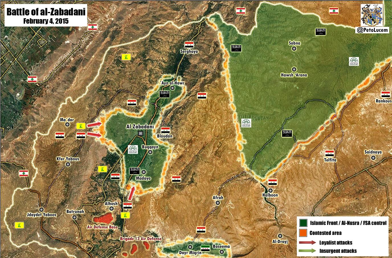
Peto Lucem new map clearly show Madaya, Buqqayn, 'Ayn al-Hawr to be rebel held. Zabadani seem to be contested only to the east. Also, the villages of Sabna and Hawsh 'Arana are rebel held in the Qalamoun area.
https://pbs.twimg.com/media/B9A8QzxIMAEeeSj.jpg:large — Preceding unsigned comment added by 179.179.159.29 (talk) 18:09, 4 February 2015 (UTC)
 Done Hanibal911 (talk) 19:32, 4 February 2015 (UTC)
- No. Zabadani is for sure contested: SAA presence inside the city is well documented as discussed in the past even if probably the core of the city is still rebel controoled. The map is not detailed enough to show the SAA presence inside the city. Therefore Zabadani should go back to contested.Paolowalter (talk) 07:46, 5 February 2015 (UTC)
- I agree with the IP,Peto Lucem is pro-regime and in this case we can use his reports(map)beacause Zabadani was contested before now he is showing that rebels captured it.
- SOHR reported that 4 members of the regime forces killed when the Islamic battalions targeted them in al- Zabadani.SOHR So this means that the army still present in the city. Hanibal911 (talk) 21:02, 5 February 2015 (UTC)
- Hanibal911 this source there are clashes on the mountain and around the city not inside the city.Lindi29 (talk) 21:12, 5 February 2015 (UTC)
Al-hasakah area
This is pro gov source, but in this area we do not too many reliable source. Sana news: army established full control over the villages of al-Watwatiyeh, Jammo, Jammo Farm, and the eastern part of Bab al-Kheir village south of Hasaka city. [9]. I find Al Watutiyah very close to 121 Artillery base(83.26.172.121 (talk) 18:52, 4 February 2015 (UTC)) The advance of SAA in this area is supported also by SOHR even if it does not mention names (see discussion in [10]). Therefore we can assume that this village is one of those mentioned by SOHR and change it.Paolowalter (talk) 11:28, 5 February 2015 (UTC)
"The loyalist forces captured the villages of Al-Watwaatiyyeh, Al-Jamou, and Mazra’ Al-Jamou in the vicinity of the recently liberated Baab Al-Khayr earlier this morning." almasdarnews — Preceding unsigned comment added by 91.65.91.237 (talk) 19:19, 5 February 2015 (UTC)
Report by Masdar [11] the SAA has captured 11 Hasakah villages. Please try and find their locations and at least one more source that can confirm the report is correct. EkoGraf (talk) 00:39, 6 February 2015 (UTC)
Kurdish source confirmed the capture of the village of Sabaa Skor by the SAA [12]. Its locaiton is here [13]. Please add it to the map. Thanks! EkoGraf (talk) 13:29, 6 February 2015 (UTC)
- ARA News it is biased pro opposition source so we can use it for displayed success of army. Hanibal911 (talk) 14:24, 6 February 2015 (UTC)
Bab al-Hawla
SOHR Reported that regime forces bombarded and opened heavy machine gun.Contested ?SOHRLindi29 (talk) 21:06, 4 February 2015 (UTC)
I agree that it should be marked contested. 2601:0:B200:F7D9:D4D4:29E7:5AF:E5EC (talk) 01:47, 5 February 2015 (UTC)
- SOHR not said about Bab al-Hawla he said about town of Houla which controlled by rebels. Also SOHR not said about clashes in this town only said that Syrian army bombarded and opened heavy machine gun fire on al-Hawla. So that nothing needs to be changed.SOHR Hanibal911 (talk) 08:36, 5 February 2015 (UTC)
Semi-protected edit request on 5 February 2015
 | It is requested that an edit be made to the extended-confirmed-protected module at Module:Syrian Civil War detailed map. (edit · history · last · links · sandbox · edit sandbox · sandbox history · sandbox last edit · sandbox diff · transclusion count · protection log) This template must be followed by a complete and specific description of the request, that is, specify what text should be removed and a verbatim copy of the text that should replace it. "Please change X" is not acceptable and will be rejected; the request must be of the form "please change X to Y".
The edit may be made by any extended confirmed user. Remember to change the |
Add
{ lat = "36.659", long = "39.613", mark = "Location dot black.svg", marksize = "6", label = "Raj'an", link = "Raj'an", label_size = "0", position = "left" },
Sources: http://wikimapia.org/#lang=en&lat=36.659314&lon=39.612236&z=16 http://www.understandingwar.org/sites/default/files/ISIS%20Sanctuary%20Map%20JAN.%2015.%202015.pdf
Add { lat = "36.601", long = "39.492", mark = "Location dot black.svg", marksize = "6", label = "Nussif Tall", link = "Nussif Tall", label_size = "0", position = "left" },
Sources: http://wikimapia.org/#lang=en&lat=36.690653&lon=39.492502&z=16&m=bs http://www.understandingwar.org/sites/default/files/ISIS%20Sanctuary%20Map%20JAN.%2015.%202015.pdf Add { lat = "36.644", long = "39.226", mark = "Location dot black.svg", marksize = "6", label = "Za'zu'ah", link = "Za'zu'ah", label_size = "0", position = "left" },
Sources: http://wikimapia.org/#lang=en&lat=36.644078&lon=39.225976&z=16 http://www.understandingwar.org/sites/default/files/ISIS%20Sanctuary%20Map%20JAN.%2015.%202015.pdf
I want to show these ISIS controlled villages, as ISIS supplies its fighters near Serekaniye using this road.
2601:0:B200:F7D9:ED96:280A:4E54:5A9F (talk) 1:50, 5 February 2015 (UTC)
Talbiseh
SOHR reported about clashes between the regime troops and rebels in the city of Talbise.SOHR So we need mark this town as contested. Hanibal911 (talk) 08:41, 5 February 2015 (UTC)
- Talbiseh is a rebel stronghold. It is not contested. Just south of the city there is the Malouk army complex from which army troops attack the border of the city. This has been going on for months, but the rebels are holding up well... so the city is not contested & the clashes can still be reported routinely for months in the future along the same pattern. No evidence that army troops can do anything other than hit & run attacks. The red semi-circle is enough for now. Tradediatalk 12:38, 5 February 2015 (UTC)
- SOHR reported clashes around Talbsieh mostly in the north area.here.As for now the red cricle is enough.Lindi29 (talk) 12:55, 5 February 2015 (UTC)
- Those are original research. The pro-opp source states cleraly of fighting inside the city. That has always been sufficient to turn the city contested.Paolowalter (talk) 18:38, 5 February 2015 (UTC)
Please read the references critically. The first reference only says the regime shelled Talbise (in one sentence among many referring to other locations). The second reference says "clashes around Talbisa". Both suggest that regime forces are not in the town. Thus neither is adequate to change its' status to contested, even if it weren't a rebel stronghold. André437 (talk) 17:06, 6 February 2015 (UTC)
- André437 I Agree that we need more data before mark this town as contested. But if you carefully read this source SOHR you can will notice that it says "Clashes took place between the regime forces and fighters in the vicinity of al- Mashrafeh area in the east of Homs with information about casualties on both sides. Other clashes took place between the same parties in the city of Talbise." Source clear said that clashes in the city of Talbise. Hanibal911 (talk) 20:01, 6 February 2015 (UTC)
Deir ErZoor
From [14] the SAA control arounf Deir Erzoor should be enlarged.Paolowalter (talk) 18:38, 5 February 2015 (UTC)
Sorry, Twitter sources are not accepted here. You said so yourself multiple times when somebody proposed using Twitter sources to show opposition gains :) — Preceding unsigned comment added by 84.24.43.183 (talk) 20:33, 5 February 2015 (UTC)
- No way only 1 twitter source,SOHR Reports have been ignored since 27 january for the airport and there were only edits for the Regime,when there were clashes around the airport and no 1 has mention that,only I did that,so what should do,we should enlarge the Isis presence around the airport.SOHR,SOHR,SOHR,SOHR,SOHR,SOHR,SOHR,SOHR,SOHR.Lindi29 (talk) 20:43, 5 February 2015 (UTC)
- Elijah J Magnir is a 100% neutral,reliable source, SOHR is no longer, especially in Deir-Ez-Zor. They have been so wrong so many times regarding news from that area. The "twitter" source is sufficient to make change to the map. XJ-0461 v2 (talk) 20:46, 5 February 2015 (UTC)
- Lindi29 SOHR also clear said that army advances in this area. So we cant put black icon near airport. Hanibal911 (talk) 20:58, 5 February 2015 (UTC)
- Elijah J Magnir is a 100% neutral,reliable source, SOHR is no longer, especially in Deir-Ez-Zor. They have been so wrong so many times regarding news from that area. The "twitter" source is sufficient to make change to the map. XJ-0461 v2 (talk) 20:46, 5 February 2015 (UTC)
- XJ-0461 v2 he is not 100% neutral beacause on his reports are many mistakes,example 25 january he tweets for this jihadistEjmAlrai,without any confirmation or source that he his dead and I tweet to him that's a lie and he is not from mitrovica and his name is not abu abdallah and you need to show a reliable source not biased sources from kurds beacause,I said to him I have reliable source from were he comes from and that he his still alive beacause on my local news there were another report for his death now this is the second one and was a lie,his parents spoke to him on the phone and denied that he is dead,and on 2 febuary he teweets that he is not dead.EjmAlrai,that confirms that his report and sources are not 100% reliable and can not be compare with SOHR who is the main source for this war and also has her own activist in Syria.Lindi29 (talk) 21:08, 5 February 2015 (UTC)
- That is only one example and that is of a KIA, which a very hard to verify. We are talking about accuracy concerning battle events. The concensus here is the EJM is 100% reliable and neutral. If you feel that this is incorrect, make a section on the talk page dedicated to it where you present your evidence so that other editors here may consider it.XJ-0461 v2 (talk) 22:32, 5 February 2015 (UTC)
- Hanibal911 I agree with you that we show Isis presence near the airport and to show the regime advance too but to show were the regime has clearly advance not just to enlarge the map for the Regime where there are clashes everyday at the airport and in the map is showing Isis not even close to the airport but it show in Jaffra where Isis has already captured it.Lindi29 (talk) 21:25, 5 February 2015 (UTC)
EjmAlrai is the AL RAI Chief International Correspondent. We have used him as a source to update the map dozens of times in the past, as well as a source for updating Syria-related articles, and he is neutral. EkoGraf (talk) 00:38, 6 February 2015 (UTC)
YPG newly liberated villages confirmed by YPG official account and Reporters in kobane
https://twitter.com/Kobane_YPG/status/563754661665308672
https://twitter.com/jackshahine/status/563823001549160448
ISIS has retreated from most of the villages this map is wrong edit it. — Preceding unsigned comment added by Creepz55 (talk • contribs) 12:46, 7 February 2015 (UTC)
Stop using so many biased twitter sources to report YPG gains please, at the very least wait for official YPG statements before changing to Yellow villages that get reported as liberated as late as 3 days after the change is made here.
190.67.154.84 (talk) 13:03, 7 February 2015 (UTC)
Biased? You're funny People edit this map with Pro iran & pro assad sources and some pictures taken back in 2012. If any ISIS source,Assad source report something then it's 100% right, right?
Also if this was a lie you would see ISIS media trying to prove that YPG are lying. Sorry but i believe YPG official account.
___
I am pro-YPG pal, but I don't see the point in rushing to put everything yellow as soon as it gets mentioned in twitter, Jackshanine is a p. good source but in that particular tweet he is quoting another user whose realiability we don't know about.
Again, wait a bit until YPG (or ANHA) post the list of liberated villages so the changes can be done accordingly and we don't end putting yellow contested villages, like it happened with Sheran, which was marked yellow when in truth it was being besieged for 2 days.
190.67.154.84 (talk) 13:38, 7 February 2015 (UTC)
https://twitter.com/jackshahine/status/564092268064542720 -->
Also you can see here from a raqqa S.I inside source that ISIS are preparing for a war outside tel ebyad
https://twitter.com/Raqqa_sl1/status/564082763914305537 https://twitter.com/Raqqa_sl1/status/564082719433711616 https://twitter.com/Raqqa_sl1/status/564082785649180672
Wow ISIS retreating from jarablus according to Elijah J magnier. https://twitter.com/EjmAlrai/status/564094868494888960
And btw ANHA already posted a list in their kurdish section http://ku.hawarnewsagency.com/ypg-li-3-eniyen-kobane-28-gund-hatin-rizgarkirin/
newly liberated villages
Eastern front
Qeremûx, Kara Mezra, Xirab Kort, Girêmoz, Walaqî, Boztepe, Êynbat, Gundê Xerîb, Cumelî, Kortekê, Kopeksatan, Girbelav, Îto and Til Sofî
Southern front Kaşê Berkelê, Dongêzê ya Biçuk û Mezin, Yaramaz, Bogazê,Girdê
Western front Selîm, Qurqurî, Korelî, Dîkmetaş, Aşmê, Elem and H.Şûkrî — Preceding unsigned comment added by Creepz55 (talk • contribs) 17:21, 7 February 2015 (UTC)
- From what I've understood through numerous sources, YPG in western front has reached the river, on southern front YPG is at Sarrin grain depot and on the eastern front around Bexdik village. So the current map must be updated. Roboskiye (talk) 18:35, 7 February 2015 (UTC)
Al-hasakah and area Qamishili area
In last few days it was many raport about advance SAA in this two area. Almasdar [15] and [16] - The Syrian Arab Army (SAA) – in cooperation with the National Defense Forces – asserted their control over the villages of al-Zaraza, Shamasa, Tal Mohamed, al-Tiben, Khaled, Howedka, Akoula villages and nine other farms in the area. (Tal Hamees area). SAA offensive confirm by SOHR and EjmAlrai without name. Why Melabiya turn black when in this area SAA take few village and [17] [18] Ivan Sidorenko report about army prepare to retake base 121 And one more raport [19] that army control the entire way from Qamishli to Tell Brak (217.99.116.28 (talk) 13:41, 7 February 2015 (UTC))
It´s very interesting news. Sadly no source except Almasdar give names to the liberated villages and Almasdar is by many here considered not trustworthy. Me myself think that Almasdar is at least as trustworthy as SOHR in reporting gains and losses of ground among the fighting parts. Map should be updated. Rhocagil (talk) 18:03, 7 February 2015 (UTC)
- Rhocagil I agree, if we use SOHR we should use al-Masdar too atleast we know who edits the articles at al-Masdar and could easily contact the editor unlike SOHR which is unrealible on clashes where FSA is not involved and untrustworthy due the following reasons: ""SOHR" has no incorporation, no official reports, no physical address. They never explain their methodology, only assert random numbers."Spenk01 (talk) 21:48, 7 February 2015 (UTC)
- Spenk01 SOHR or he Rami Abdul Rahman is a one man office that work out of his apartment and does not think he has to explain his methodology (About SOHR NY Times). Anyway I think most of the news from SOHR are valid or good enough for making editorial changes to the map. With that said, I also like to say that I totally agree with you on your opinion on Al-Masdar, we know who edits the articles and it should be used. Rhocagil (talk) 23:37, 7 February 2015 (UTC)
- Reliable source reported that ISIS pulls out of 15 villages and farms in Al-Qamishli. Syrian army NDF Approaching IS in Tal Hamis and Tal al-Braq.Elijah J. Magnier Hanibal911 (talk) 09:39, 8 February 2015 (UTC)
Another 2 report about this offensive [20] and EjmAlrai confirm SAA advance. (217.99.116.28 (talk) 09:36, 8 February 2015 (UTC))
![[20]](https://pbs.twimg.com/media/B9Q7NV7CYAAPCse.png)
Islamic State withdraw
Many reliable sources mentioning a TOTAL Islamic State withdraw from Northern Aleppo countryside, Elijah J Magnier being one of then:
https://twitter.com/EjmAlrai/status/564053529183412224 https://twitter.com/EjmAlrai/status/564069326861238272 https://twitter.com/EjmAlrai/status/564094868494888960
Yes, we need to wait further confirmations, but is most likely a Idlib/Latakia style withdraw like in february 2014, to focus on Raqqa, Hasakah and Deir Ez-Zor(and Iraq). They had no men to maintain the fronts around Kobane, and would be trapped by YPG/FSA from the east and FSA/IF/JaN from the west. — Preceding unsigned comment added by 177.156.1.66 (talk) 19:54, 7 February 2015 (UTC)
- Here map from pro opposition source which showed a situation in this area. Hanibal911 (talk) 20:16, 7 February 2015 (UTC)
Of course we can't do anything at this moment. There is much talk about this, probably most of things being reported are 50% true and 50% rumors.
- Liwa Thuwar Raqqa (FSA linked) source said that FSA relebes (not said exactly which groups) captured the village of Qudaja, located right here.
- Same group published photos showing the bridge in Qarah Qawzak. They said that IS still controls the town. Also they published these photos saying " We managed to cut the supply route between Sarinn ".
- Kataib Shamal (FSA from Kobane) said the same thing for Qudaja vilage, but a friend also said that it's not important because other villages around were also captured.
- Another interesting channel.
Does anyone agree to change Dir Barah, Barkh Batan and Quwaytaji to green ? Mainly because pro-opposition sources (including the channels above) are talking about villages located in the south of these 3 locations, mentioning for example Qudaja as captured but not mentioning the 3 villages that I wrote here. DuckZz (talk) 21:41, 7 February 2015 (UTC)
https://twitter.com/archicivilians/status/564184662172368898?lang=sv reports of more villages also it doesn't only say fsa but burqan al furat (ypg jabhat akrad sham al simal and LTR) — Preceding unsigned comment added by Creepz55 (talk • contribs) 22:21, 7 February 2015 (UTC)
FSA+Akrad and islamist groups
Hawar ala nahr should be edited https://twitter.com/arabthomness/status/564102969147547648?lang=sv — Preceding unsigned comment added by Creepz55 (talk • contribs) 22:26, 7 February 2015 (UTC)
We can't use biased sources like this. This guy is not just pro-opposition but pro-opposition + not reliable. DuckZz (talk) 23:42, 7 February 2015 (UTC)
Kafr Shams
According to IvanSidorenko, Government forces are trying to capture this town (including Masharah and Deir Adas), here and here. Opinions ? DuckZz (talk) 23:57, 7 February 2015 (UTC)
Just like always: wait a couple days. There are reports from both pro gov. and opposition sources that SAA/NDF will strom Deir al Adas in the coming days, and finally launching an offensive on Douma. — Preceding unsigned comment added by Totholio (talk • contribs) 00:09, 8 February 2015 (UTC)
- SOHR clear said that clashes still in surroundings town of Kafr Shams but not inside the town.SOHR Hanibal911 (talk) 09:15, 8 February 2015 (UTC)
- Violent clashes are still taking place between the regime forces supported by militiamen against the Islamic and rebel battalions in the vicinity of the town of Kafar Shams, amid mutual bombardment between the two parties.SOHR Hanibal911 (talk) 09:18, 8 February 2015 (UTC)
- DuckZz IvanSidorenko not a reliable source which just publishes the pro-government and the pro-opposition data. Hanibal911 (talk) 09:25, 8 February 2015 (UTC)
- Violent clashes are still taking place between the regime forces supported by militiamen against the Islamic and rebel battalions in the vicinity of the town of Kafar Shams, amid mutual bombardment between the two parties.SOHR Hanibal911 (talk) 09:18, 8 February 2015 (UTC)
How much more proof does the editor want? This is starting to get funny
https://www.youtube.com/watch?v=N-PIbV01LjQ&feature=youtu.be
This map should be updated because it's getting funny now.