
Talk:Control of cities during the Syrian civil war: Difference between revisions
| Line 602: | Line 602: | ||
Lucem map February 18 showing the Army controlled Part from Rityan https://pbs.twimg.com/media/B-I6iDCCQAAO8Lg.jpg:large --[[User:LogFTW|LogFTW]] ([[User talk:LogFTW|talk]]) 16:56, 18 February 2015 (UTC) |
Lucem map February 18 showing the Army controlled Part from Rityan https://pbs.twimg.com/media/B-I6iDCCQAAO8Lg.jpg:large --[[User:LogFTW|LogFTW]] ([[User talk:LogFTW|talk]]) 16:56, 18 February 2015 (UTC) |
||
It looks like some more changes to the map are required: Neutral source Al-Monitor describes what appears to have been a large coordinated government offensive around Aleppo. It says regime forces through control of Saifat launched an offensive and captured Hardetneen and Bashkoy, and that ongoing contested fight for Ratyan is taking place: http://english.al-akhbar.com/content/blow-ankara-syrian-army-makes-advances-aleppo-offensive. |
|||
On the western side of Aleppo, Al-Monitor reports that government forces made advances in al-Maamel and "able to control a number of farms in the west near Haritan and get close to the Castello crossroads, Aleppo’s northwestern entrance which is connected to the international road". It adds "Air Force intelligence forces stationed in the area to advance and control seven urban blocks in the vicinity of the Air Force Intelligence building and al-Rasoul al-Azam Mosque." and that regime army forces "was also able to advance in al-Rashidin al-Rabia" |
|||
Revision as of 16:58, 18 February 2015
| This is the talk page for discussing improvements to the Control of cities during the Syrian civil war article. This is not a forum for general discussion of the article's subject. |
Article policies
|
| Find sources: Google (books · news · scholar · free images · WP refs) · FENS · JSTOR · TWL |
| This page is not a forum for general discussion about Control of cities during the Syrian civil war. Any such comments may be removed or refactored. Please limit discussion to improvement of this article. You may wish to ask factual questions about Control of cities during the Syrian civil war at the Reference desk. |
| This article is of interest to the following WikiProjects: | |||||||||||||||||||||||||||||||||||||||||||||
| |||||||||||||||||||||||||||||||||||||||||||||


.svg)
| To help centralise discussions and keep related topics together, Template talk:Syrian Civil War detailed map redirects here. |
Template:Syrian Civil War sanctions
|
Index 1, 2, 3, 4, 5, 6, 7, 8, 9, 10 |
|
This page has archives. Sections older than 7 days may be automatically archived by Lowercase sigmabot III when more than 3 sections are present. |
Kurdish presence in aleppo
source https://twitter.com/sergermed/status/561985092890144768
https://twitter.com/sergermed/status/560952310776750080
https://twitter.com/sergermed/status/560576534407565312
same account have also mentioned about kurds+fsa rebels in Qazel, Ghara/Yani yaban, Dalhah & Baghirin these villages aren't even marked in this map. — Preceding unsigned comment added by Creepz55 (talk • contribs) 00:49, 2 February 2015
YPG in KOBANE
According to this confirmed source YPG controlls zorava tel aotk korabi and susan are they even marked on the map?
https://twitter.com/ColdKurd/status/561294811094065153 — Preceding unsigned comment added by Creepz55 (talk • contribs) 00:54, 2 February 2015
Joum Ali in kobane.
Joum ali in kobane
https://twitter.com/jackshahine/status/561974858951950336?lang=sv
It's completelly liberated why does the map show ISIS presence? — Preceding unsigned comment added by Creepz55 (talk • contribs) 00:58, 2 February 2015
Newly liberated villages in Kobane
till-Hajb ,Tayri ,karab-kurd , jilak liberated https://twitter.com/ColdKurd/status/562279177546891264
- Let's wait some more sources or some pictures to confirm that YPG is really inside those villages. Sheran town has been marked as Kurdish controlled since 5 days ago, but actually it was liberated by YPG only last night. https://twitter.com/jackshahine/status/562232838133919744 The same source (Jack Shahine) posted a picture of Aydiq village here: https://twitter.com/jackshahine/status/562274741936209920 .in the southern front, but I have yet to see a picture of Rubi. --8fra0 (talk) 17:33, 2 February 2015 (UTC)
- 7 more villages liberated last night: Xerabnas (Qaramogh), Satiyah, Qabajigh (Qarajokh), Tashli Huyuk (Tashluk), Mojek, Bir Arab, Bishalti. This is reflected in dozens of sources: http://www.lebanon24.com/mobile/details/1002615 http://www.lebfeed.com/%D9%88%D8%AD%D8%AF%D8%A7%D8%AA-%D8%AD%D9%85%D8%A7%D9%8A%D8%A9-%D8%A7%D9%84%D8%B4%D8%B9%D8%A8-%D8%AA%D8%B3%D9%8A%D8%B7%D8%B1-%D8%B9%D9%84%D9%89-%D9%82%D8%B1%D9%89-%D9%82%D8%A8%D8%A7%D8%AC%D8%BA-%D9%88/ http://www.alahednews.com.lb/fastnews/253822/-%D8%A7%D9%84%D9%88%D8%AD%D8%AF%D8%A7%D8%AA-%D8%A7%D9%84%D9%83%D8%B1%D8%AF%D9%8A%D8%A9-%D8%AA%D8%B3%D9%8A%D8%B7%D8%B1-%D8%B9%D9%84%D9%89-%D9%82%D8%B1%D9%89-%D9%82%D8%A8%D8%A7%D8%AC%D8%BA-%D9%88%D8%B7%D8%A7%D8%B4%D9%84%D9%88%D9%83-%D9%88%D9%82%D8%B1%D9%85%D9%88%D8%BA-%D9%88-%D8%B3%D8%AA%D9%8A-%D9%88-%D9%85%D9%88%D8%AC%D9%83-%D9%88-%D8%A8%D9%8A%D8%B1%D8%B9%D8%B1%D8%A8#.VNHxy2jF870 http://slabnews.com/article/158887/ http://www.masdark.com/arabic/304311.html
- I think that we can change them. On the other hand, Tel Ghazal is still contested: https://twitter.com/jackshahine/status/563117893823774721 --8fra0 (talk) 23:41, 4 February 2015 (UTC)
- 7 more villages liberated last night: Xerabnas (Qaramogh), Satiyah, Qabajigh (Qarajokh), Tashli Huyuk (Tashluk), Mojek, Bir Arab, Bishalti. This is reflected in dozens of sources: http://www.lebanon24.com/mobile/details/1002615 http://www.lebfeed.com/%D9%88%D8%AD%D8%AF%D8%A7%D8%AA-%D8%AD%D9%85%D8%A7%D9%8A%D8%A9-%D8%A7%D9%84%D8%B4%D8%B9%D8%A8-%D8%AA%D8%B3%D9%8A%D8%B7%D8%B1-%D8%B9%D9%84%D9%89-%D9%82%D8%B1%D9%89-%D9%82%D8%A8%D8%A7%D8%AC%D8%BA-%D9%88/ http://www.alahednews.com.lb/fastnews/253822/-%D8%A7%D9%84%D9%88%D8%AD%D8%AF%D8%A7%D8%AA-%D8%A7%D9%84%D9%83%D8%B1%D8%AF%D9%8A%D8%A9-%D8%AA%D8%B3%D9%8A%D8%B7%D8%B1-%D8%B9%D9%84%D9%89-%D9%82%D8%B1%D9%89-%D9%82%D8%A8%D8%A7%D8%AC%D8%BA-%D9%88%D8%B7%D8%A7%D8%B4%D9%84%D9%88%D9%83-%D9%88%D9%82%D8%B1%D9%85%D9%88%D8%BA-%D9%88-%D8%B3%D8%AA%D9%8A-%D9%88-%D9%85%D9%88%D8%AC%D9%83-%D9%88-%D8%A8%D9%8A%D8%B1%D8%B9%D8%B1%D8%A8#.VNHxy2jF870 http://slabnews.com/article/158887/ http://www.masdark.com/arabic/304311.html
8fra0 when you were editing Kobane region (Tel Ghazal), did you accidentally edit Tall Ghazal in Hasakah to contested? Anyway you are better with editing the map then me so could you please change Tall Ghazal to Kurd held. I didn´t see any source for Tall Ghazal anywhere. Rhocagil (talk) 01:45, 5 February 2015 (UTC)
- I edited the wrong Tel Ghazal, sorry. --8fra0 (talk) 11:11, 5 February 2015 (UTC)
New sources say that Tal Ghazal, Makhraj, Khazinah, Dibrak and other villages are in YPG hands: https://twitter.com/jackshahine/status/563372401409667072 This source has proved to be very reliable in the past days. Maybe Rubi and Tafshu are still in IS control as there is no evidence of clashes there, they should be edited I think. — Preceding unsigned comment added by 8fra0 (talk • contribs) 16:31, 5 February 2015 (UTC)
Also Rubi is under YPG control according to https://twitter.com/m22bali/status/563420727626723328 --8fra0 (talk) 19:48, 5 February 2015 (UTC)
And Rubi silos also in YPG control, Tafshu village liberated by FSA and YPG jointly according to https://twitter.com/jackshahine/status/563456403059515392 and https://twitter.com/arabthomness/status/563452316117135364 --8fra0 (talk) 22:02, 5 February 2015 (UTC)
New reports of Selib, Dikmatash and Kor Ali under YPG control in Kobane western front: https://twitter.com/arabthomness/status/563749990183763969 --8fra0 (talk) 17:33, 6 February 2015 (UTC)
please change milê from black to yellow because the news says peshmerga attack isis from milê which south of kobanî.
http://rudaw.net/kurmanci/kurdistan/100220156
and change name of kobanê to kobanî plase. it's name is kobanî and all wikipedia use that name https://en.wikipedia.org/wiki/Koban%C3%AE
Azad4707 (talk) 01:41, 11 February 2015 (UTC)
please change khorkhori, sal, sarunj, dibrak seykhan, hamamik, karus, sharabati and birak from black to yellow because the offical account of ypg in kobanî. https://twitter.com/Kobane_YPG Azad4707 (talk) 11:07, 11 February 2015 (UTC)
Tall Abyad/Girê Spî villages
Alarabiya, clearly states that the frontline is now in the villages of Tall Abyad: http://www.alarabiya.net/ar/arab-and-world/syria/2015/02/08/%D8%AA%D8%AC%D8%AF%D8%AF-%D8%A7%D9%84%D9%85%D8%B9%D8%A7%D8%B1%D9%83-%D8%A8%D9%8A%D9%86-%D8%AF%D8%A7%D8%B9%D8%B4-%D9%88%D8%A7%D9%84%D8%A3%D9%83%D8%B1%D8%A7%D8%AF-%D9%81%D9%8A-%D8%B1%D9%8A%D9%81-%D8%A7%D9%84%D8%B1%D9%82%D8%A9-.html It meantions villages of Juran, Hurriya, Kurmaza and Kenane. Unfortunately this sourced edit got removed on be half of a map which itself bases its updates on other sources, and which seems to have missed to check Arabic section of Alarabiya! Please update and correct the map. Roboskiye (talk) 07:30, 9 February 2015 (UTC)
An addition to Alarabiya, this source mentions Sarzuri (Zarzuri) and Bir Arab under YPG control. These villages are just two km away from Juran and Hurriya, located north and south of them respectively. Roboskiye (talk) 10:54, 9 February 2015 (UTC)
It does not matter how many verifiable sources you provide. The reaction is same and simple: They refer to the same outdated map and revert you! By the same logic one can re-edit whole of wiki map according to that inaccurate map. Any one daring to answer this? Roboskiye (talk) 20:49, 9 February 2015 (UTC)
- Here is more info about Tall Abyad front. 8 villages under YPG control and 8 villages scene of fighting. http://www.masdark.com/arabic/312599.html Roboskiye (talk) 20:55, 9 February 2015 (UTC)
- Yes, I dare to answer this. Editors find it easier to copy an unreliable amateur map, rather than look for real sources… Tradediatalk 05:55, 12 February 2015 (UTC)
Sheick Miskin
From pro-opp sources [1] Sheikeh Meskin contested. In any case I have never seen convincing proof that SAA is not present anymore in the east part of the city.Paolowalter (talk) 09:51, 10 February 2015 (UTC)
Clashes are on the east, in the village of Qarfa, pro-opposition are saying that Rebels are trying to advance from that village but we don't have any neutral sources showing that rebels control it. DuckZz (talk) 11:41, 10 February 2015 (UTC)
- That is your interpreation not what is written in the source. Attack on Qarfa does not exclude fighting in Sheick Miksim as well.Paolowalter (talk) 14:47, 10 February 2015 (UTC)
- Paolowalter Let's look at interpretations, shall we ?
- 1) Your reference has one sentence saying "Fierce clashes operate between FSA and regime forces in Al-Sheikeh Meskein front in Daraa."
- Nothing more, nothing less. It does not define where the "front" is. Is it 10 km north of the town, 10 km east, or where ? Note that Izra is only 4 km away, to the north-east. Maybe the "front" is on the edge of Izra ?
- 2) You characterize the source as pro-opposition, but there is no indication of that. Since the source uses neutral language ("FSA", "regime") and provides translations in arabic, english, and kurdish, it is probably based in Syria with a neutral or moderate outlook, and unlikely strongly pro-regime or strongly pro-ISIS. (Both groups being against the kurdish language.)
- 3) The control of Sheikh Maskin has already been discussed with references provided, and the consensus was that it is rebel controlled. You should provide adequate references to counter this consensus. Your info is only enough to say that both sides probably have forces in proximity of the general area of the town. André437 (talk) 11:33, 13 February 2015 (UTC)
Daraa?
Why are Masharah and Al-Tayhah suddenly red? There has been no discussion here, no sources given to change the towns. So, why? — Preceding unsigned comment added by 84.31.204.195 (talk) 14:44, 10 February 2015 (UTC)
- SAA and Hezbollah fully control TayhaElijah J. Magnier In Quneitra and Daraa fronts, SAA and Hezbollah took control of Madharah,Deir-Maqer,Al-Tiha Elijah J. Magnier And stop writing nonsense that changes are made without specifying sources. Hanibal911 (talk) 15:14, 10 February 2015 (UTC)
- Also confirmed that SAA and Hezbollah control of Deir al-Adas.Elijah J. Magnier Hanibal911 (talk) 15:17, 10 February 2015 (UTC)
You are using Twitter. So if Markito, Archicivilians or Thomas van Linge say rebels take villages, we change them to? Because then we can make Tell Antar and Qarfa to rebel held, as well as the village of Al-Faqa and Bargah. Nice change in politics over here :) great! — Preceding unsigned comment added by 84.31.204.195 (talk) 15:32, 10 February 2015 (UTC)
- There is some differences between pro rebel Markito, Archicivilians or Thomas van Linge, pro regime peto lucem, KeepingtheLeith and neutral EjmAlrai. Read about rules in wiki. (83.26.143.237 (talk) 15:39, 10 February 2015 (UTC))
- All editors have recognized this source Elijah J. Magnier as a reliable and neutral. And we use it for display the success the army, rebels, Kurds and ISIS. But Markito, Archicivilians or Thomas van Linge it is biased pro opposition sources and in accordance with the rules we do not use pro opposition sources to display success rebels. We can use this source for display the success by army. But we can use for display the success by rebels pro government sources Peto Lucem, Al-Masdar, Syrian Perspective and some other. Hanibal911 (talk) 15:43, 10 February 2015 (UTC)
Success? Many videos from Deir al-Adas today showing continued fighting. One Twitter source claims the regime retakes Masharah, and it is red. More than 10 Twitter sources say fighting in Qarfa, and we don't even discuss making it contested. This map, gentleman, is becoming one big joke. Sorry to state it like this, because I do appreciate your work, but I'll be following the real maps made by Twitter authors who do not believe every romour :) — Preceding unsigned comment added by 84.31.204.195 (talk) 16:37, 10 February 2015 (UTC)
- I'm sorry but Hanibal911 here is right. ChrissCh94 (talk) 16:47, 10 February 2015 (UTC)
- About clashes in Qarfa and Deir Al Adas said only a pro opposition sources. But this more reliable source Elijah J. Magnier because it's not just page in Twitter the activist from social network it is page in twitter of the chief international correspondent from Kuwait news agency. Also we cant use pro-rebel amateur video for displayed success by rebels. Hanibal911 (talk) 16:50, 10 February 2015 (UTC)
- Also Israeli source Mossad News reported that Hezbollah take control of Deir al-Adas.Mossad News Hanibal911 (talk) 17:11, 10 February 2015 (UTC)
- SOHR report that clashes are still taking place in Deir al-Adas also confirms attacks on Qafra and Namer the issue that i opend beacause pro-regime and pro-opp twitter sources reported that rebels are fighting in outskirts of this villages.here,also al-masdar shows Mashrah in rebel control but shows also regime advances near this town so mb a red siege on these 3 villages it's more logical.here.Lindi29 (talk) 17:28, 10 February 2015 (UTC)
And someone change Deir al-Adas to ... green (83.26.143.237 (talk) 19:29, 10 February 2015 (UTC))
- Archicivilians maps have been proven to be inaccurate and this can be seen by the rather small, misplaced contested line. Archicivilian has used this map for most of his changes, and he usually over exaggerates the oppo gains in addition Jumada (talk) 19:42, 10 February 2015 (UTC)
- Jumada I understood, but if we have reliable info from EjmAlrai that SAA control this city and I don't see new his maps from Dara. Last from january. (83.26.143.237 (talk) 20:54, 10 February 2015 (UTC))
- Several mentioned sources now mention that Deir al-Adas should be red or at least contested, Tell Qareen should be contested, Kafr Shams should be besieged or contested, Kafr Nasij should be besieged from the north and possibly from the east, Mashara should be contested or at least besieged from the north and Khan Arnabah should have the green ring removed, it's outdated. MesmerMe (talk) 20:21, 10 February 2015 (UTC)
- Jumada I understood, but if we have reliable info from EjmAlrai that SAA control this city and I don't see new his maps from Dara. Last from january. (83.26.143.237 (talk) 20:54, 10 February 2015 (UTC))
84.31.204.109 .Go follow archicivilians map its right up your street extreme bias pro opposition .If MOSSAD news say Hizbollah have taken Deir al Adas its confirmed so stop throwing your toys out the pram and grow some ;)31.50.78.246 (talk) 20:48, 10 February 2015 (UTC)pyphon
- The known vandal Alhanuty has changed Mashara to green based on a misunderstanding of an outdate source and Deir al-Adas to green without any reason. I reverted the first change but I do not want to break the 1RR rule. Can somebody revert the second? More important, can Alhanuty be blocked for the next year? He just vandalize the map. Paolowalter (talk) 21:03, 10 February 2015 (UTC)
[2] This sources says the government advanced in north-western Daraa province and that the situation in Deir-Al-Adas is critical (pro-opp claim) but I also found footage from SANA [3] showing the army cleaning up Deir-al-Adas which means the rebels have lost the town. Daki122 (talk) 21:06, 10 February 2015 (UTC)
Also pro-opp sources are saying rebels lost Tel Mari and the 2 villages next to it [4]. Daki122 (talk) 21:10, 10 February 2015 (UTC)
- It seems Deir Al Adas is regime held. Reuters even quoted rebel sources saying Deir Maker is regime held. [5] ChrissCh94 (talk) 21:52, 10 February 2015 (UTC)
Hard to say because SAA did capture Deir Adas, that's why we have those news from western medias (and Elijah). The thing is that clashes then reerupted inside the town according to SOHR and other sources. Pro-opposition channels are saying that rebels recaptured the town but of course we can't use that. For now, we can leave it to contested, as we will have a 100% confirmation in few days. DuckZz (talk) 22:21, 10 February 2015 (UTC)
- Nothing new that rebel source lie. Today thay said that repelled regime attack on this city and kick out regime forces, another report that they fighting inside the city, now they said that recaptured this city. It impossible win, stability, lost and win in this same time. (83.26.143.237 (talk) 22:37, 10 February 2015 (UTC))
- Come to think of it, I cannot remember a time when rebels have lost a village and not claimed to have recaptured it the next day. XJ-0461 v2 (talk) 23:14, 10 February 2015 (UTC)
- its a pro-oppo 'moral boost' to lie about the situation on the ground; which is created to mislead their followers on facebook and twitter in an effort to reduce panic, usually the rumour is forgotten and nobody seems to care who created the rumour in the first place, by the end of it they assume they never lost a thing, this was well known for the town of Morek, long after it was lost to government forces, many spoke of a massive rebel counter attack which never came, eventually they moved on to Daraa which was seeing more action Jumada (talk) 23:37, 10 February 2015 (UTC)
- Come to think of it, I cannot remember a time when rebels have lost a village and not claimed to have recaptured it the next day. XJ-0461 v2 (talk) 23:14, 10 February 2015 (UTC)
XJ and all other editors SOHR has confirmed that clashes have continued in Deir Adas, so stop inventing reasons to put Deir Adas as regime-held, the regime captured happened in the afternoon, but clashes resumed in the evening, and the situation is changing, so the best thing to do is go with Hannibal's edit and keep it as contested. Alhanuty (talk) 23:59, 10 February 2015 (UTC)
- Does not matter. More reliable and more recent sources such as EJM and the Mossad [come on man!] have declared the town to be in SAA hands. We will not leave the town contested forever so Abdel-Rahman can play catch up. No other reliable source has reported that the rebels reentered the town. XJ-0461 v2 (talk) 00:01, 11 February 2015 (UTC)
SOHR is more reliable than biased EJM, SOHR proved to be authentic for a longtime, also SOHR report has came after the previous reports. Alhanuty (talk) 00:21, 11 February 2015 (UTC) http://syriahr.com/en/2015/02/8-rebels-killed-by-an-ambush-by-regime-forces-in-dara-countryside/ http://www.syriahr.com/2015/02/%D8%A7%D8%B3%D8%AA%D8%B4%D9%87%D8%A7%D8%AF-%D9%86%D8%AD%D9%88-10-%D9%85%D9%82%D8%A7%D8%AA%D9%84%D9%8A%D9%86-%D9%81%D9%8A-%D9%83%D9%85%D9%8A%D9%86-%D9%84%D9%82%D9%88%D8%A7%D8%AA-%D8%A7%D9%84%D9%86/ http://www.syriahr.com/2015/02/%D9%86%D8%AD%D9%88-20-%D8%B4%D9%87%D9%8A%D8%AF%D8%A7%D9%8B-%D9%81%D9%8A-%D9%85%D8%AD%D8%A7%D9%81%D8%B8%D8%A9-%D8%AF%D8%B1%D8%B9%D8%A7-%D8%A8%D9%8A%D9%86%D9%87%D9%85-14-%D9%85%D9%82%D8%A7%D8%AA%D9%84/
- If i'm not mistaken in the translation here is even a video of the SAA touring in Deir al-Adas https://www.facebook.com/video.php?v=748649765250148 Spenk01 (talk) 00:21, 11 February 2015 (UTC)
Just wanted to say my part, we have been using Elijah J. Magnier's reports for a long time as a neutral source to show BOTH sides advances and he has proven reliable. If he says the town is government-held it probably is and the reported fighting is most likely taking place in the outskirts. EkoGraf (talk) 00:29, 11 February 2015 (UTC)
Eko, it clearly states "clashes taking place in Der al-Adas town between regime forces backed by Hezbollah and Iranian fighters against Islamic battalions.", so i the town is clearly contested, and this report is more recent than EJM, also EJM has a biasness towards the regime. Alhanuty (talk) 00:43, 11 February 2015 (UTC)
- Do not lie. EJM has no bias towards the regime. He is a fully neutral, credible, and experienced reporter, unlike SOHR. SOHR never really has done a good job with its translations anyway. Since no other reliable source has reported a rebel counterattack [which would be big news], SOHR should be ignored in the face of all the sources against it such as EJM, Al-Masdar, Reuters, THE MOSSAD!!, etc. XJ-0461 v2 (talk) 01:19, 11 February 2015 (UTC)
scale of miles the SOHR report is more recent than the other sources, so contested, EJM has a biasness towards the regime, and this has been seen in other situations before, he claimed that Deir Adas was taken 24 hours before the regime actually entered it, even pro-regime source leith even was skeptical on it, also Al-Masdar is a very pro-regime source and is heavily biased, and all editors know that. Alhanuty (talk) 01:22, 11 February 2015 (UTC)
- Deir Adas is gone, clashes are now in other towns. Just relax Alhanuty and double check your grammar to make it easy for everyone to understand what you're trying to say, thanks Jumada (talk) 02:17, 11 February 2015 (UTC)
SOHR confirmed that there is clashes inside Deir Adas. Alhanuty (talk) 02:37, 11 February 2015 (UTC) why doesn't this map have a scale of miles that would be vary helpful. Evey map should have a scale of miles. — Preceding unsigned comment added by 50.245.243.173 (talk) 01:16, 11 February 2015 (UTC)
- Alhanuty Elijah J. Magnier it is reliable and neutral source and you also this previously recognized. SOHR partially biased source and it's known to all. so let's not raise this issue. Hanibal911 (talk) 06:53, 11 February 2015 (UTC)
- Also many reliable sources said that SOHR it is antigovernment source and SOHR some times said that Syrian troops it is bloody murderers and this says that it is not not a neutral source. He also uses an flag of Syrian opposition on its website that confirms that SOHR support the Syrian opposition. While Elijah J. Magnier it is neutral and reliable source. As I have said earlier this is a twitter Elijah J. Magnier of a chief international correspondent from Kuwait news agency Al Rai. Hanibal911 (talk) 07:13, 11 February 2015 (UTC)
- Syrian forces had captured the town of Deir al-Adas.The Daily StarMulhakAlbawabaReuters Hanibal911 (talk) 07:39, 11 February 2015 (UTC)
- Here's also a video inside town of Deir al Adas although we cant use it to display success by army because this video from the pro government source SANA Hanibal911 (talk) 08:02, 11 February 2015 (UTC)
- Syrian forces had captured the town of Deir al-Adas.The Daily StarMulhakAlbawabaReuters Hanibal911 (talk) 07:39, 11 February 2015 (UTC)
- I think Dayr Makir is contested following this recent Mayadeen report [6] ChrissCh94 (talk) 08:40, 11 February 2015 (UTC)
- Nevermind just saw this news on Al Mayadeen: Deir Maker is regime held. [7] ChrissCh94 (talk) 08:47, 11 February 2015 (UTC)
- Just as the last nail in the coffin of the Deir Adas discussion SOHR.Paolowalter (talk) 09:32, 11 February 2015 (UTC)
Maybe this article can help? http://www.qasion-news.com/en/content/regime-forces-enter-deir-adas-after-fsa%E2%80%99s-withdrawal. Regime entred Deir Al Addas, but with risk of ambushes of FSA. Can anyone tell me as what kind of source I must treat Qasion News? Raspoetin89 — Preceding unsigned comment added by 2A02:1811:A016:A800:4D72:F08B:F94C:F2D3 (talk) 10:18, 11 February 2015 (UTC)
- qasion news it is pro opposition source. Hanibal911 (talk) 10:28, 11 February 2015 (UTC)
- Deir al-Adas under control by Syrian troops and Hezbollah.Elijah J. Magnier Hanibal911 (talk) 10:39, 11 February 2015 (UTC)
- A pro-opp map with some extra info https://twitter.com/hashtag/Daraa?src=hash. Besides news we already know, it confirms Mashara under SAA control and Himrin as well. Paolowalter (talk) 11:02, 11 February 2015 (UTC)
Ok, its been confirmed by SOHR [8]. SAA has captured Deir al-Adas. EkoGraf (talk) 11:03, 11 February 2015 (UTC)
- Also a world news editor from Haaretz (Israeli source) Asaf Ronel confirmed that Deir al-Adas under control by Syrian troops and Hezbollah. Asaf Ronel and some other sources here also also another geopolitical and security analyst reported that after the seizure of Deir al-Adas by the Syrian troops, clashes reported in Kafr al-Shams. Michael Horowitz Hanibal911 (talk) 11:04, 11 February 2015 (UTC)
- Also biased pro opposition source reported that rebels retreated this morning from Deir al-Adas.Archicivilians Hanibal911 (talk) 11:20, 11 February 2015 (UTC)
- SOHR reports some SAA advance but I cannot locate the hills. Paolowalter (talk) 11:46, 11 February 2015 (UTC)
- Pro opposition source confirmed that Mashara under control by army.Syrian Rebellion Observatory Hanibal911 (talk) 11:47, 11 February 2015 (UTC)
- This is Tall Sarja [9] while this is Tall Arous [10]. Rebels still hold the following: Sultaniyah and Tall Sultaniyah - Sabsaba and Tal Sabsaba - Tell Qareen and KafrNasej - Kfar Shams (encircled) and Tall Antar. Clashes are now ongoing in both Tell Fatimah and Tell Alaqiyah. That is the frontline now. ChrissCh94 (talk) 12:52, 11 February 2015 (UTC)
- I got this info from the local coordination committees of po-gov and pro-opp sides ChrissCh94 (talk) 12:58, 11 February 2015 (UTC)
- Pro opposition source confirmed that Mashara under control by army.Syrian Rebellion Observatory Hanibal911 (talk) 11:47, 11 February 2015 (UTC)
sohr confirmed saa captured dayr makir http://www.syriahr.com/2015/02/%D8%A7%D9%84%D8%B3%D9%8A%D8%B7%D8%B1%D8%A9-%D8%B9%D9%84%D9%89-%D8%A8%D9%84%D8%AF%D8%A9-%D8%AF%D9%8A%D8%B1-%D9%85%D8%A7%D9%83%D8%B1-%D9%85%D9%86-%D9%82%D8%A8%D9%84-%D8%AD%D8%B2%D8%A8-%D8%A7%D9%84%D9%84/176.232.198.167 (talk) 13:52, 11 February 2015 (UTC)
- Also pro rebel source Syrian Rebellion Observatory confirmed that Dayr Makir and Deir Adas under control by Syrian troops. Syrian Rebellion Observatory Hanibal911 (talk) 15:34, 11 February 2015 (UTC)
- Also another one pro opposition source confirm that regime forces Hezbollah and Shia militants recaptured villages Dayr Makir, Deir al-Adas, Danaj and Habbariyah in northern Daraa.Thomas van Linge Hanibal911 (talk) 16:15, 11 February 2015 (UTC)
- According to pro opposition source heavy battle for control of Tell 'Antar & Tell Alaqiyah.here Hanibal911 (talk) 16:35, 11 February 2015 (UTC)
- Rebels reported that army captured part of Kafr Nasij.here Hanibal911 (talk) 08:37, 12 February 2015 (UTC)
- Also opposition ground activists confirm that rebels retreated from Deir Adas to Kafr Nasij despite denial by 1st army(FSA)here And activist reported that when 1st Army(FSA) claimed they recaptured Deir Adas and captured there regime motorcycle . Activist says it happened in Kafr Nasij.here Hanibal911 (talk) 08:45, 12 February 2015 (UTC)
- Hanibal911,ChrissCh94 according to peto lucem map it shows Kfar Nasij besieged and Masharah contested or besieged on one the north side.Lindi29 (talk) 13:26, 12 February 2015 (UTC)
- Also opposition ground activists confirm that rebels retreated from Deir Adas to Kafr Nasij despite denial by 1st army(FSA)here And activist reported that when 1st Army(FSA) claimed they recaptured Deir Adas and captured there regime motorcycle . Activist says it happened in Kafr Nasij.here Hanibal911 (talk) 08:45, 12 February 2015 (UTC)
- Rebels reported that army captured part of Kafr Nasij.here Hanibal911 (talk) 08:37, 12 February 2015 (UTC)
- According to pro opposition source heavy battle for control of Tell 'Antar & Tell Alaqiyah.here Hanibal911 (talk) 16:35, 11 February 2015 (UTC)
- Also another one pro opposition source confirm that regime forces Hezbollah and Shia militants recaptured villages Dayr Makir, Deir al-Adas, Danaj and Habbariyah in northern Daraa.Thomas van Linge Hanibal911 (talk) 16:15, 11 February 2015 (UTC)
- Lindi29 Map from Petro Luce for 10 February so this means that for the moment this map outdated. And new map from pro opposition source showed that Masharah under control by army Syrian Rebellion Observatory Also rebels reported that army captured part of Kafr Nasij.here Also reliable source reported that clashes ongoing in Kfar-Shams, Kfar-Nasej and Hamreet.Elijah J. Magnier Hanibal911 (talk) 13:44, 12 February 2015 (UTC)
I found some good maps here >>SchwarzeSun Daraa Map 12 feb 2015<< of the situation today. hope it helps Jumada (talk) 16:25, 12 February 2015 (UTC)
Hills in Daraa
Every hill in Daraa/Quneitra has become a military base/CP. But since the countryside is rugged, we have a lot of those hills therefore a lot of those military sites. I suggest we keep the very important hills and the hills on the front-line while removing the hills that never saw action and those far from the front-line. The map in Southern Syria is too crowded. Important hills in my opinion: - Western-Eastern Tell Ahmar - Tell Jabiah - Tell Al Joumou' - Tell Krum - Tell Bzaq As well as the hills on the front-line (especially those recently mentioned such as Tell Mer'i etc. near Deir Al Adas) I also suggest we only keep the important military formations (Brigades, regiments, divisions etc.) while removing the useless housing units. Nawa and Shaykh Miskin for example are too crowded. Opinions? ChrissCh94 (talk) 14:29, 11 February 2015 (UTC)
- Agreed. — Preceding unsigned comment added by 217.129.242.132 (talk) 14:49, 11 February 2015 (UTC)
Agree but every time we here SAA or rebels take one of these editors will ask that they are added again .31.50.78.246 (talk) 15:11, 11 February 2015 (UTC)pyphon
- I also forgot Tell Harra the biggest most important in the area. Yes but I also agree with the editors on adding back the hill IF AND ONLY IF it sees front-line action. Once it is firmly back in someone's territory we remove it IF it is not considered an important hill (such as those mentioned earlier in the post). We will therefore only keep the important hills deep inside someone's territory. ChrissCh94 (talk) 15:25, 11 February 2015 (UTC)
That would make sense ,less clutter .31.50.78.246 (talk) 15:46, 11 February 2015 (UTC)pyphon
- Instead of removing icons from the map, let's just make it not display the label, by setting label_size="0". This will give us more space.
- It will still show the icon, and also the label on mouseover. This also allows us to easily restore the label if/when wanted.
- As well, I would suggest not displaying the label for hills. They are only important as control points to protect/attack nearby towns and bases. We should probably have a special icon for hills. I'll be working on icons tomorrow if anyone thinks it is a good idea. André437 (talk) 12:21, 13 February 2015 (UTC)
217.129.242.132, please use : for indent, not spaces, and preview your post. André437 (talk) 12:21, 13 February 2015 (UTC)
Kurdish Forces in Tal Abyad (Girê Sipî)
Kurdish Forces Attack Tal Abyad. There Should be yellow-black spots.
German Source: http://www.n-tv.de/politik/Kurden-nehmen-Kampf-um-Tal-Abjad-auf-article14481826.html — Preceding unsigned comment added by 87.159.202.49 (talk) 16:55, 11 February 2015 (UTC)
The source actually says that after the recapture of Kobani their focus will now be the Tal Abyad valley. So, its something that has possibly not happened yet and it was talking about the valley, not the town. EkoGraf (talk) 06:26, 12 February 2015 (UTC)
Semi-protected edit request on 11 February 2015
This edit request to Module:Syrian Civil War detailed map has been answered. Set the |answered= or |ans= parameter to no to reactivate your request. |
Please Edit the Spot of Tal Abyad. It is black at the moment. It should be yellow-black. Kurdish Forces are attacking it at the moment. German Source Thanks 87.159.202.49 (talk) 17:00, 11 February 2015 (UTC)
- No the source mention just that the campaing just started and the Kurds are moving toward Tal Abyad. They are still far from engaging fighting in the town. The source does not provide info on villages where fighting would take place ora taken by kurds.Paolowalter (talk) 19:54, 11 February 2015 (UTC)
Deir a-Zaghb
Pro opposition source reported that rebels captured the hamlet of Deir a-Zaghb to southwest of town Fu'ah on the road to Idlid.here [www.syriadirect.org/rss/1843-syria-direct-news-update-2-10-15] But we cant use data from pro opposition source for display the success by rebels. So that maybe someone have the data from a reliable source. Hanibal911 (talk) 09:22, 12 February 2015 (UTC)
Almasdar news reported the same .31.50.78.246 (talk) 09:35, 12 February 2015 (UTC)pyphon
- You can provide a source and I will add this hamlet on the map. Hanibal911 (talk) 09:47, 12 February 2015 (UTC)
 Done pro government source confirmed.hereAl Masdar Hanibal911 (talk) 10:12, 12 February 2015 (UTC)
Yes but why is it turned grey ?i thought it said (islamic front)31.50.78.246 (talk) 15:59, 12 February 2015 (UTC)pyphon
kobane
What's the source for isis recaptured mitras, Ziyarete, Xerab eto and many villages in south?--Creepz55 (talk) 17:18, 12 February 2015 (UTC) — Preceding unsigned comment added by Creepz55 (talk • contribs) 16:52, 12 February 2015 (UTC)
- In fact ISIS didn't recapture anything, the real problem is that the sources that stated that YPG forces were in Ziyarete, Xerab Eto and villages around Serrin were not confirmed at all. Moreover, YPG official sources stated yesterday that YPG was clashing with ISIS in Darbazin and Miskhu, so it is not realistic that YPG controls Zirayete and Xerab Eto, that would mean that IS forces are completely surrounded and for sure we would have heard about that. For Sarrin grain Silos and near villages, the last confirmed sources showed pictures of ISIS fighters there. 8fra0 (talk) 09:38, 13 February 2015 (UTC)
Size of map
Can anyone reduce the size of the map at the top of the page? It seems overly large to me. Natg 19 (talk) 20:12, 12 February 2015 (UTC)
- That depends of your PC Display, however you ae not the first one demanding a reducction of the map, the problem with this its that some small but strategicaly important villages will not be visible.200.48.214.19 (talk) 20:52, 12 February 2015 (UTC)
Reduce lol ? I have a standard laptop 15,5 inch monitor and the map is really small, i have to zoom the page to 130% to barely see the villages ... does anyone else think that the map should be zoomed in ? DuckZz (talk) 21:55, 12 February 2015 (UTC)
- That depend of your PC Display or browser in my work break, some PC show the map extremely huge. But it depends of the computer. The main reason i find redusing the size of the map impossible its that some villages would be imposible to see. 200.48.214.19 (talk) 13:48, 13 February 2015 (UTC)
- The map is much larger than any normal screen resolution. If not "adjusted" by the browser, you should only see a small part of the map at a time. (This is by design, to allow showing more locations on the map.)
- Many browsers are able to resize the map (or any other inset like the map) to the size of the screen. If that happens for your browser, you should zoom it to at least 250% to see it full size. It probably is configurable in the browser settings.
- Mozilla browsers (like firefox, seamonkey, etc) won't do this for our map (at least not by default), so that can be corrected if it happens with such browsers. It is better to avoid automatic resizing + subsequent zooming, as likely the display will be less clear.
- Hope that helps ... André437 (talk) 04:21, 14 February 2015 (UTC)
Added villages in Homs ,why?
What was the point of adding all those tiny villages in east Homs. If we added all villages of their size in the rest of syria the map would be overloaded . I am in favour of showing small villages if they are on the front line but if not they are pointless .31.50.78.246 (talk) 21:50, 12 February 2015 (UTC)pyphon
- Totally agree. Rhocagil (talk) 01:10, 13 February 2015 (UTC)
- I agree. Even because they are rarely mentioned so that it is almost impossible to be informed if they switch control.Paolowalter (talk) 07:13, 13 February 2015 (UTC)
I kind of feel the same about the black dots around Saba in Hasakah. Anyway I would like more opinions from others, to maybe get a consensus to remove some of the villages i Homes as they are not in the frontline. Rhocagil (talk) 14:35, 13 February 2015 (UTC)
- I agree, all the extra black dots don't represent any villages since they're simply hamlets and are of no significant value to any side. Its clutter.MesmerMe (talk) 17:42, 13 February 2015 (UTC)
The editor who added them obviously wanted to show ISIS control of the area but has got carried away. At least halve of them are not needed. 31.50.78.246 (talk) 18:15, 13 February 2015 (UTC)pyphon
- The point for add those villgaes is beacause in that area there was a big vacum and also it wasn't showing the frontline I didn't add them myself but I provided source, also adding villages(dots) it makes the map more clearly and easier for people to read.Lindi29 (talk) 19:22, 13 February 2015 (UTC)
- It doesn't make it clear since it gives a wrong indication of the map. It currently looks like the area east of Homs is densely populated, which is something not every remotely true. While adding villages isn't a problem, adding 40 at the same time both in Homs and Hasakah give the wrong picture and should be (partly) removed.MesmerMe (talk) 21:29, 13 February 2015 (UTC)
- MesmerMeLOL.It doesn't make it clear since it gives a wrong indication of the map?,This map is created with reliable sources not by my opinion.Populated?,The regime is on the advance and taking more villages in this area and you are saying they are not populated who are they fighting with Ghosts ?,look even if they are not populated with a great number of people even if it less it doesn't matter beacause this is a war map and we show who is in controll on this places no matter if they regime,rebels,kurds or jihadists.We are not here for giving bad or good pictures but to show who is in controll and that's the truth if you have any reliable sources please provide,beacause the map is very clear.Lindi29 (talk) 21:52, 13 February 2015 (UTC)
- The point for add those villgaes is beacause in that area there was a big vacum and also it wasn't showing the frontline I didn't add them myself but I provided source, also adding villages(dots) it makes the map more clearly and easier for people to read.Lindi29 (talk) 19:22, 13 February 2015 (UTC)
I think the smaller villages you are talking about should be reduced in size on the map, according to satellite and wikimapia of course, to decrease their apparent importance. Not all of them are exactly that size, of course. 2601:0:B200:F7D9:E405:3B3C:3A9A:1531 (talk) 02:17, 14 February 2015 (UTC)
Lindi29 .You say you provided source so where is it? I have not seen it on here .81.156.224.112 (talk) 18:57, 16 February 2015 (UTC)pyphon
Himrit
Himrit is under SAA control [11].Paolowalter (talk) 07:13, 13 February 2015 (UTC)
- Even though the credibility of Al-Masdar has improved quite alot in recent months, I think we should wait for 1 more source, neutral or pro-opp to confirm the event since the area is quite a hotspot at the moment. ChrissCh94 (talk) 10:06, 13 February 2015 (UTC)
- Agreed with ChrissCh94 we need confirmation from pro opposition source or neutral source. Hanibal911 (talk) 10:46, 13 February 2015 (UTC)
- Is that sufficient? https://twitter.com/IvanSidorenko1/status/566407330636787714Paolowalter (talk) 10:48, 14 February 2015 (UTC)
- I would say so. The rebels have been awfully silent about the situation so far, suggesting that it is true. What do the other editors think? XJ-0461 v2 (talk) 17:17, 14 February 2015 (UTC)
Talbiseh
Again fighting in Talbisah SOHR. Time to switch it contested. Paolowalter (talk) 13:29, 13 February 2015 (UTC)
- Talbiseh is a rebel stronghold. It is not contested. Just south of the city there is the Malouk army complex from which army troops attack the border of the city. This has been going on for months, but the rebels are holding up well... so the city is not contested & the clashes can still be reported routinely for months in the future along the same pattern. No evidence that army troops can do anything other than hit & run attacks. The red semi-circle is enough for now. Tradediatalk 13:52, 14 February 2015 (UTC)
You are not producing any evidence to support your claims. The rule states that if figting are rerported by pro-opp source in a city controlled by opposition (SAA advance) we must mark it on the map. This source openly talks of clashes 'in al- Hlaleyyi and Hosh Hajjo areas in the city of Talbise.' Similar statements were reported several times in the past.Paolowalter (talk) 16:06, 14 February 2015 (UTC)
- I do not need to produce any evidence. There are plenty of sources that were produced in the past and there is a consensus about it. The sources say that Talbise is rebel-held & describe in details the situation in it & around it. You are the one who has to produce evidence that the status of the city has changed from the past. The “rule” you mention does not exist. We mark a city contested if it is contested. Talbise is not, and we had reports of “clashes” before but never marked it as contested because it is not. Clashes could be hit & run attacks and that does not make a city contested. You mention the expression “SAA advance”, however in this case, there is no evidence for such an advance (or SAA occupation of a part of the town). For small towns that we know nothing about, we might put them on the map as contested based on clashes report, because this might be the only information we will get about them. Talbise is an important strategic city. If it becomes contested, we will hear that it is contested because it is important news. Does any source (including pro-gov) claim that it is contested or that army is making progress in it? No. It is not more contested than nubl or zahraa were. We turn a town contested based on clashes report if we don’t know the previous situation in the town or we hear about some kind of an offensive by one of the parties. Contested means we cannot say one specific side controls it. In this case, we can say rebels control it. Tradediatalk 22:10, 14 February 2015 (UTC)
Khurus Kobane
Khurus village in kobane close to qara qawzaq should be contested and not isis held.
https://twitter.com/archicivilians/status/565257184855220228 --Creepz55 (talk) 16:37, 13 February 2015 (UTC)
- You are right, but this source is 3 days old and no other sources (not even YPG official media) have said nothing about it 8fra0 (talk) 17:59, 13 February 2015 (UTC)
Pro-Kurdish source from inside Kobane says YPG are not in control of Xerab Eto but that clashes are ongoing, please change to contested:
https://twitter.com/jackshahine/status/566616553148661760
He also reports that clashes are going on near Jadah village:
https://twitter.com/jackshahine/status/566585598602129408
It would be a YPG advance but would it be acceptable to mark it as besieged from North?
179.33.157.37 (talk) 16:25, 14 February 2015 (UTC)
- Jack Shahine statements have always been very reliable in the past weeks, I think that he could been used as a permanent source for editing this map. So Xerab Eto is contested and Jadah, Kuraftar and Turaman are in YPG hands, I would add those villages rather than marking Khurus besieged --8fra0 (talk) 17:28, 14 February 2015 (UTC)
- I have edited Xerab Eto and added Jaadah contested, let's wait for further developments --8fra0 (talk) 17:39, 14 February 2015 (UTC)
Zor Mexar and Bayadiya CONTESTED not YPG controlled according to jackshanine quoted by another kurdish activist:
https://twitter.com/ArjDnn/status/566735706987704320
179.33.157.37 (talk) 23:11, 14 February 2015 (UTC)
Syrian army advances in Hasakah
The pro opposition source reported that after clashes against Islamic State the Syrian troops took over several villages and continued its advancement in the countryside of Hasakah province, in northeastern Syria. Also earlier the last friday Syrian troops had seized 16 villages in the countryside of the cities of Qamishli and Hasakah, following fierce clashes with militants of the Islamic State.ARA News Maybe someone of editors have more information. Hanibal911 (talk) 18:18, 13 February 2015 (UTC)
Masharah
According to this twitter source Masharah is contested here but according to this video it shows rebel attacking Tall Bzaq from the northren outsikrts of Mashrah here, but in the map this town is Regime held ? Lindi29 (talk) 22:47, 13 February 2015 (UTC)
they will say, we need a source, not videos. Alhanuty (talk) 23:04, 13 February 2015 (UTC)
- You are Right :) XJ-0461 v2 (talk) 23:13, 13 February 2015 (UTC)
Dear Lindi29,
You will achieve nothing. The chief editors here will claim Twitter is no source. However, they will use Twitter themselves if it showes SAA advances. Also, you need at least 3 sources for any rebel advance, whilst adding red semicircles and contested icons for a SAA advance needs only 1. You would do better to make your own map of follow Twitter maps, because we won't achieve any neutrality in southern Syria on this one ... regretfully. — Preceding unsigned comment added by 84.24.43.183 (talk) 10:10, 14 February 2015 (UTC)
Hahaha the double standard idiots crying, ooo my god iranians are fighting with SAA and afghans, meanwhile jihadists from 83 countries are fighting in the ranks of the snackbars. They are using NEUTRAL UNBIASED sources like Elijah who got info FROM THE GROUND without any media or activist bias. He knows everything before it reaches the media. It was clear that Deir al adas was taken by SAA cause there were videos from the city. Not biased archivilians and al qaeda supporter markito twitter LOL Totholio (talk | contribs)
- This is a tweet of the international correspondent Elijah J. Magnier of Kuwait News Agency. But markito0171 and archicivilians opposition sources and we cant use their data to show the success of the rebels. So you 84.24.43.183 always criticize the changes made to the favor army but nothing said when the we used data from Twitter to display the progress of rebels and ISIS. So it's a clear indication that you are fully supported rebels and opposed the army. So what is your opinion biased and not objective. But I try to be objective and observe the rules of editing. Hanibal911 (talk) 12:46, 14 February 2015 (UTC)
- It is just pro opposition source and we cant use this source to displayed success by rebels. We need data from neutral sources. Also previously pro opposition activist Cedric Labrousse showed that villages of Deir al-Adas, Deir Makir, Mashara and Habbariyah under control by army.Syrian Rebellion Observatory Hanibal911 (talk) 12:27, 14 February 2015 (UTC)
Let's see what happens. This source has been pusblished: https://now.mmedia.me/lb/en/reportsfeatures/564830-the-assad-regimes-daraa-campaign-is-a-desperate-defensive-maneuver and http://www.huffingtonpost.com/nicholas-noe/the-battle-for-southern-s_b_6668744.html It states that fighting is ongoing around Deir al-Adas, and that the regime has not been able to advance by much. So Kafr Naisj, Tell Antar and Sabsaba should be green since the only real advances of the SAA were around Dayr Makir, Deir al-Adas and near Himrit. Also, we never received neutral sources for Masharah and At-Tayhah. Both are shown as rebel held on multiple maps. Some of you claim those maps are too pro-FSA to use. Well ... they've shown Sabsaba and Himrit under rebel control for months. You editors claimed that was nonsense. And see ... the SAA is attacking right those villages that had been red al along on this map. So those maps were right, PetroLucem was not. I'm predicting: it will be shot down as a source for this map because:
- It's "not detailed enough"
- It's too pro-opposition
- It doesn't fit the mood of the editors, because they don't want to think for themselves
let's see how long it takes before some Al-Masdar, PetroLucem of Elijah Twitter source shows up to make Kafr Shams contested? I say: two days at the most. — Preceding unsigned comment added by 84.31.204.195 (talk) 13:16, 14 February 2015 (UTC)
- Firstly this source The Huffington Post not said that clashes around Deir al-Adas. And Secondly this source NOW Newd just publish data from the Abu al-Majd al-Zoabi one of the rebel leader in South front. But as I have previously said the pro opposition source Sedric Labrouse confirmed that villages of Deir al-Adas, Deir Makir, Mashara and Habbariyah under control by army.Syrian Rebellion Observatory And this is a tweet Elijah J. Magnier of the international correspondent so it is a reliable source. Hanibal911 (talk) 13:32, 14 February 2015 (UTC)
- Also previously pro FSA source confirmed that Syrian troops captured part of the town Kafr Nasij.here Hanibal911 (talk) 13:42, 14 February 2015 (UTC)
Map about Daraa from a source I do not know http://www.mediafire.com/convkey/47c9/txl7ypxdoaa23lbzg.jpg. Can it be used? It confirms Himrit under SAA control as reported by Al Masdar. It is the third source mentionng it, is it sufficient?Paolowalter (talk) 21:09, 14 February 2015 (UTC)
- Ivan mentioned that an FSA activist confirmed it. Your map, however, cannot be used since it is not authoritative [we cannot guarantee its reliability since be do not know who made it].XJ-0461 v2 (talk) 00:01, 15 February 2015 (UTC)
Sources for Kobane countryside
I suggest to stop editing the map using as a source the maps provided by these twitter users: https://twitter.com/MarkMonmonier and https://twitter.com/ChuckPfarrer because they are proved to be not reliable at all, they keep showing an exaggerated YPG advance which is denied on a daily basis even by the YPG official media. For istance, the grain silos near Sarrin and surrounding villages are yet IS held but the are edited to YPG controlled on a daily basis using those biased twitter users as a source. --8fra0 (talk) 01:03, 15 February 2015 (UTC)
Agreed, let's stick to ANHA/official YPG daily village recount for captured villages and jackshanine's reports for contested/besieged, or at the very least open up a thread every time you want to use one of these maps so their veracity can be contrasted with additional sources.
179.33.157.37 (talk) 05:54, 15 February 2015 (UTC)
- Khan Mamid in southern Kobane and Zurzuri east of Kobane are according to these Kurdish sources recaptured by YPG: http://adarpress.net/index.php/2013-07-29-08-54-39/6244-%D9%85%D8%B1%D8%A7%D8%B3%D9%84-%D8%A2%D8%AF%D8%A7%D8%B1-%D8%A8%D8%B1%D8%B3-%D8%A7%D9%84%D9%82%D9%88%D8%A7%D8%AA%D9%8F-%D8%A7%D9%84%D9%83%D9%8F%D8%B1%D8%AF%D9%8A%D8%A9-%D9%81%D9%8A-%D9%83%D9%88%D8%A8%D8%A7%D9%86%D9%8A-%D8%AA%D8%B3%D8%AA%D8%B9%D9%8A%D8%AF%D9%8F-%D9%82%D8%B1%D9%89-%D9%82%D8%B1%D9%8A%D8%A8%D8%A9-%D9%85%D9%86-%D8%A7%D9%84%D8%B7%D8%B1%D9%8A%D9%82-%D8%A7%D9%84%D8%AF%D9%88%D9%84%D9%8A
According to agreed upon as reliable jackshanine YPG in control of villages Bexdix, Kultib and Aqbash east of Kobane, the former two are already marked as YPG controlled in this map, also they're besieging Eydanee.
https://twitter.com/jackshahine/status/567452962646409216
190.67.159.64 (talk) 22:54, 16 February 2015 (UTC)
- YPG advancing south of M4 highway, controlling villages such as Joxur/Showkhur/Joqur, which will be added to the map. In addition to this village of Girik (Kirik Mawla) is under YPG control: http://www.alahednews.com.lb/fastnews/256388/%D9%82%D9%88%D8%A7%D8%AA-%D8%A7%D9%84%D8%AD%D9%85%D8%A7%D9%8A%D8%A9-%D8%A7%D9%84%D9%83%D8%B1%D8%AF%D9%8A%D8%A9-%D8%AA%D8%B3%D9%8A%D8%B7%D8%B1-%D8%B9%D9%84%D9%89-5-%D9%82%D8%B1%D9%89-%D8%BA%D8%B1%D8%A8-%D9%83%D9%88%D8%A8%D8%A7%D9%86%D9%8A-%D9%88-10-%D9%82%D8%B1%D9%89-%D8%AC%D9%86%D9%88%D8%A8%D9%87%D8%A7-%D9%88%D8%B4%D8%B1%D9%82%D9%87%D8%A7-%D8%A8%D8%B9%D8%AF#.VOSzCvnF870
- http://qasion-news.com/ar/content/node/15802#sthash.roTXE8OH.dpbs
- http://www.syriaday.net/%D9%85%D8%AD%D9%84%D9%8A/%D8%A7%D9%84%D9%80-ypg-%D9%8A%D8%B9%D9%84%D9%86-%D8%B3%D9%8A%D8%B7%D8%B1%D8%AA%D9%87-%D8%B9%D9%84%D9%89-%D9%82%D8%B1%D9%89-%D8%AC%D8%AF%D9%8A%D8%AF%D8%A9-%D9%81%D9%8A-%D8%BA%D8%B1%D8%A8-%D9%88%D8%AC%D9%86%D9%88%D8%A8-%D9%83%D9%88%D8%A8%D8%A7%D9%86%D9%8A/
- There are more villages mentioned in the sources which will be added after identification and finding their position in order to to clarify the frontline. Roboskiye (talk) 16:03, 18 February 2015 (UTC)
Ma'arrat Hurmah
SOHR reported that clashes in the town of Ma’arret Hermeh in the southern countryside of Idlib between al- Nusra Front and gunmen from the town.SOHR and pro opposition source Syrian Rebellion Observatory reported that Abu Hamoud the chief of Free Police in Maarat Harmah, reportedly killed by a Jabhat al-Nusra and said that It's a new wave of killings from the Al Nusra side since few weeks against local forces (including Free Police) in the Idlib province.Syrian Rebellion Observatory I ask to other editors express their views on this issue. Hanibal911 (talk) 13:41, 15 February 2015 (UTC)
- For those who dont know the Syrian Rebellion ObservatorySyrian Rebellion Observatory it is a new project of the pro opposition activist Cédric Labrousse his former project was is The Arab Chronicle يوميات الربيع العربي, by - par Cédric Labrousse Hanibal911 (talk) 13:47, 15 February 2015 (UTC)
- I've seen that and am not surprised at these Nusra-rebel conflicts. When Labrousse gets plugged into an area, he tends to have quite reliable info long before other sources. That was the case in Daraa before. Apparently it depends on his local contacts. Before he had a few on line interviews where followers (like myself) could propose questions to local contacts via him in real time. He has the advantage over many western sources that he can at least read arabic.
- He does have the down side of being a little too competitive with other reporters. Also in rapidly changing situations, he sometimes reports before the area has stabilized. (i.e., when a specific location changes hands several times in a short period.)
- As for his reports on various rebel groups, I've had no reason to doubt his info, often later confirmed by other sources. He is writing a book on Syrian rebel groups.
- Anyway, good idea to keep an eye on his new site. André437 (talk) 20:05, 15 February 2015 (UTC)
New icons are ready for your feedback
They are here for Nusra, mixed control, truce areas, etc.
Please leave your feedback in that section on my talk page.
Thanks :) André437 (talk) 17:08, 15 February 2015 (UTC)
- Let us not score map, for now we have enough icons. The only thing that can be used it is some mixed 3 way File:Test-map-ctl3-red+lime+yellow.svg File:Test-map-ctl3-red+lime+grey.svg File:Test-map-ctl3-red+yellow+black.svg Hanibal911 (talk) 17:43, 15 February 2015 (UTC)
- For Al Nusra I think we should use this icon.File:Test-map-dot-grey-68a.svg Although honestly after examining your new icons I think that we can use them. With the exception icons which showed truce I think we have to leave the old version. Hanibal911 (talk) 17:59, 15 February 2015 (UTC)
The different icons for bases, checkpoints and strategic hilltops make a lit of sense. It would make the situation presented a lot clearer.MesmerMe (talk) 19:41, 15 February 2015 (UTC)
I like the triangle mountain peak icon, the cross is not good it could be mistaken for a hospital. Rhocagil (talk) 20:27, 15 February 2015 (UTC)
- Hanibal911 great pick I like them.Lindi29 (talk) 21:12, 15 February 2015 (UTC)
I personally like this File:Test-map-dot-grey-676.svg icon. The mixed control icons may seem good, but in reality there would be such a terrible and hardline discussions about which party has presence inside a town and where. This doesn't make sense. And here is why. For example Al Nusra members are present in 80% areas where rebels are, same vice versa. Every icon would be changed, and that wouldn't make sense if a town has 500 JAN members inside and 10-40 IF members too, but we can't know that....
- A better idea is to maintain the mixed icons we already use on the map, example in Kobane area or Khan Sheykun, it's easy to adjust and looks pretty OK. DuckZz (talk) 23:53, 15 February 2015 (UTC)
Not sure why people are posting here rather than his talkpage as he asked, but as we've started, I guess I'll post here as well. I'd prefer a colour that looks less like others such as #009900. As for stable mixed control, how is this different from a truce? I would still like to see stable mixed control used, though, as it makes tracking changes easier, and stops pointless debates over which icon should be in the middle and outside of a stable control.
As for the truce icons, I think the usage of the first one looks identical how we use besieged at the moment, though besieged is generally not a truce. I would use this icon to replace the need to use multiple icons. The second one is beyond me, I really don't get why one colour gets the outside and half the middle, is this saying they control the surrounding area and part of the city?
The hill/checkpoints icons seem interesting. I don't think I'd want them to be used as you intended by and large because as far as I can tell there's little demand for them. I'd personally want one them for small settlements/buildings to avoid giving misleading impressions of population distribution. This would also have the benefit of marking points that are unlikely to receive subsequent media attention if captured, so we can more easily spot them. Banak (talk) 01:10, 16 February 2015 (UTC)
- A first response to your feedback :
- 1) It would be better to come to a consensus on the Nusra colour first, since it is used in a number of new and existing icons. All the options I gave could still be called grey, to simplify naming icons. So far we have one favouring the greenest grey, another the bluest. Remember that Nusra has chosen to put a greyish blue icon in their videos, so it seems better to favour a similar colour.
- 2) The 3-way stable mixed control icons seem to be accepted. That is something that current icons can't show. All the other icons introduced are designed to replace current icons showing the same control.
- 3) Each 2-way stable control icon will replace 3 nested ring icons. There are not many such cases since we added the inset maps for the larger cities. The new pie icons (such as red-lime) are intuitively clearer than nested circles (like red-lime-red or lime-red-lime). As well as being much easier to edit 1 icon instead of 3.
- 4) Note that I'm not adding any new colours. Although Nusra grey will (likely) change.
- 5) We currently use red-lime-red for all truces, which is same as the coding for stable mixed control. The lime truce icon explicitly says "truce with rebel control", using violet from the inset maps for the circle. The red-lime truce icon explicitly says "truce with mixed regime-rebel control". (There may not be currently any such cases outside inset maps.) So these truce icons do serve a useful purpose.
- Note that a truce is a formal agreement to not fight each other. Stable mixed control could be either neither party wants to fight the other (kurds + fsa currently) or that neither party is strong enough to overwhelm the other (kurds + regime in Hasaka)
- 6) One response suggested confusion about the red-lime truce icon. Apparently the violet truce ring is too close to red. Maybe I should change the ring colour to purple, for better contrast ?
- 7) The comment about the "+" (cross) (for hills) being often used for hospitals is a good point. So those icons should be dropped.
- That leaves the little triangles for control of strategic hills. Note that in some areas, such as Daraa, and the mountain areas running from Quneitra to Western Aleppo, such hills are common. Other areas, such as the eastern desert, not at all. So it isn't expected that the hill icon will be usable everywhere. At the moment for example, it will be very useful in Daraa. By having a distinct icon, it gives useful info intuitively. (Almost everyone recognizes the mountain peak symbol.)
- Using such a symbol for other purposes is likely to be misunderstood. But other symbols could be developed if desired.
- 8) A comment made me think of another possible icon for checkpoints : simply a small "CP", in the appropriate colour. Couldn't be mistaken for anything else, and does eliminate the current confusion between (large) bases and (small) checkpoints.
- --- so keep your feedback coming. As items are accepted by consensus, I'll rename them to permanent icons, and mark them as accepted on my talk page.
- I'd like to first finalize the Nusra grey ... André437 (talk) 09:21, 16 February 2015 (UTC)
- I do not like the proposed “checkpoint” icons (CP). They are larger than the checkpoint icons we are presently using. The checkpoint icon needs to be small as to allow it to be placed in narrow places. Also, the yellow one is invisible. Tradediatalk 19:59, 16 February 2015 (UTC)
Is possible just two color ? --LogFTW (talk) 12:43, 16 February 2015 (UTC)
- André437The mixed control icons are great it's a pain to get these 3 inner circles on the map and displayed correctly especially with the smaller villages. I applied these icons on the Libyan civil war map : https://en.wikipedia.org/wiki/Module:Libyan_Civil_War_detailed_map/doc and already it looks much better. One icon is missing though the Grey/Lime/Black stable situation. Spenk01 (talk) 16:44, 17 February 2015 (UTC)
Tradedia Totally agree with your critique of the checkpoint (CP) icons. Was just brainstorming, and made a quick mockup using html. The map would need graphic icons, and the .svg icons I make would be much smaller. Maybe "X" would work better for you ? I put an html sample on my talk page. (the icons would be a symmetric X, not a letter.) We could look at that after the other icons are finalized.
As for the yellow icon, indeed it isn't visible. It needs a grey or black border like the other yellow icons. That will be done on the final hill icon as well.
LogFTW What was your comment "just two color" referring to ?
Spenk01 I'll make a grey/lime/black stable icon for you. Note that the icons will lose their "test-" prefix when they are finalized. I'll let you know when that happens.
For the Nusra colour, we have one preference for grey-green, one for grey-blue. If no other input, I'll go for the grey-blue colour.
I adjusted the truce icons, using a purple ring instead of violet, for better contrast. Take a look.
keep your feedback coming :) André437 (talk) 18:10, 17 February 2015 (UTC)
Army offensive in Daraa Governorate and Rif Dimashq
The reliable sources reported that Syrian troops and Hezbollah fighters retook the villages of Kfar Nasej and Kfar Shams which lie roughly midway between Damascus and Deraa.The Daily Starhere Hanibal911 (talk) 13:58, 16 February 2015 (UTC)
Not sure this report is correct it seems to suggest Kfar Shams was taken in the first attack but we know the SAA are still attacking it and Khar Nasej has only been part taken we need to wait for another source before we change anything .81.156.224.112 (talk) 14:23, 16 February 2015 (UTC)pyphon
- The DailyStar is one of the most reliable neutral sources. The article is dated Feb. 16, 2015 (today). I have not seen a report today that says Kfar Shams fighting after the DailyStar article. Enough to turn Kfar Shams and Kfar Nasej to red.Ariskar (talk) 16:44, 16 February 2015 (UTC)
- From reenters-battle/ AlMsdar fighting are ongoing. When those town are taken it would be announced by many sources. They must stay contested. Errors from newpapers are common, thay know much less than us the situation on the ground.Paolowalter (talk) 17:29, 16 February 2015 (UTC)
- That almasdar source is older than the Daily Star source. XJ-0461 v2 (talk) 21:29, 16 February 2015 (UTC)
- From reenters-battle/ AlMsdar fighting are ongoing. When those town are taken it would be announced by many sources. They must stay contested. Errors from newpapers are common, thay know much less than us the situation on the ground.Paolowalter (talk) 17:29, 16 February 2015 (UTC)
I know its a reliable but no pro SAA SOURCE HAS EVEN MENTIONED IT .You could have waited a bit longer ,whats the rush .81.156.224.112 (talk) 17:00, 16 February 2015 (UTC)pyphon
This is a very reliable source and the reason we haven't heard anything from pro-gov sources could be because of the ordered media blackout around the offensive.MesmerMe (talk) 18:04, 16 February 2015 (UTC)
- Al Nusra engaged in fierce fight against Hezbollah, IRGC and SAA in Tal Antar, Inkhil and Tal Hara in reef Daraa and reef Quneitra.Elijah J. Magnier Hanibal911 (talk) 20:28, 16 February 2015 (UTC)
- Nothing mentioned about Kfar Nasej and Kfar Shams in that source Hanibal911. Pro government sources: http://www.syrianperspective.com/2015/02/al-qaeda-terrorists-suffering-enormous-losses-in-derah-as-patriotic-onslaught-continues.html mentions the capture of Kafr Naasij, as recognised by FSA document. SANA reports the frontline being further south at Zimreen town: http://www.sana.sy/en/?p=28769
- Before reverting a commonly accepted reliable source, at least provide evidence of the opposite stated by it.Ariskar (talk) 22:05, 16 February 2015 (UTC)
- I think what Hanibal was trying to get it is the fact that the front line has now moved farther south. That would not be possible without the SAA' control of those areas [Kafr Shams and Kfar Nasej]. Seeing as a reliable source has already explicitly stated that these two areas are under SAA control and another reliable source has implied it, I will change them to red unless someone has significant evidence to suggest otherwise. XJ-0461 v2 (talk) 22:10, 16 February 2015 (UTC)
- Ariskar Syrian perspective it is just a blog which also very often dont work. So it is not the source of which can refute the data from a more reliable source. Hanibal911 (talk) 22:34, 16 February 2015 (UTC)
- According to both Leith Fadel and Peto Lucem, Kafr Shams is STILL contested as of 16 February, with the SAA advancing and encircling the city and fights inside it, but no complete control for either side. It should stay contested for now. — Preceding unsigned comment added by 217.129.242.132 (talk) 03:07, 17 February 2015 (UTC)
- TheDailyStar is an independent reliable source. A pro-government blog citing FSA alledged document claims SAA captured Kafr Nasej. SANA claims the frontline is further south. Enough data based on 1 reliable source and 2 pro-gov sources.Ariskar (talk) 13:08, 17 February 2015 (UTC)
- According to both Leith Fadel and Peto Lucem, Kafr Shams is STILL contested as of 16 February, with the SAA advancing and encircling the city and fights inside it, but no complete control for either side. It should stay contested for now. — Preceding unsigned comment added by 217.129.242.132 (talk) 03:07, 17 February 2015 (UTC)
- Ariskar Syrian perspective it is just a blog which also very often dont work. So it is not the source of which can refute the data from a more reliable source. Hanibal911 (talk) 22:34, 16 February 2015 (UTC)
- I think what Hanibal was trying to get it is the fact that the front line has now moved farther south. That would not be possible without the SAA' control of those areas [Kafr Shams and Kfar Nasej]. Seeing as a reliable source has already explicitly stated that these two areas are under SAA control and another reliable source has implied it, I will change them to red unless someone has significant evidence to suggest otherwise. XJ-0461 v2 (talk) 22:10, 16 February 2015 (UTC)
If needed http://www.almasdarnews.com/article/update-syrian-armys-southern-front-offensive/ states again that Kafr Nasej and Kafr Shams are contested.Paolowalter (talk) 08:08, 18 February 2015 (UTC)
- It states also deaths and fighting inside ZimrinAriskar (talk) 11:16, 18 February 2015 (UTC)
- Ariskar Al Masdar not neutral source need confirmation from more reliable source. Hanibal911 (talk) 11:44, 18 February 2015 (UTC)
Al Nusra in Idlib province
Some sources said that Al Nusra stormed 'moderate rebels' FSA (7th Brigade) HQ's and captured a large cache of weapons and supplies in Idlib countryside.hereherehere and also reported that Al Nusra captured village Ayn al-Arus.here But I'm not sure of the reliability of these sources. So it may be someone has more data on this issue. Hanibal911 (talk) 20:43, 16 February 2015 (UTC)
- Is this a confirmation EjmAlrai? (217.99.149.146 (talk) 21:09, 16 February 2015 (UTC))
- SOHR also confirmed this data.SOHRSOHR Hanibal911 (talk) 21:11, 16 February 2015 (UTC)
Rif Aleppo change
the news confirmed that SAA get control of three villages in north of Aleppo
Ratilan and Bashkouy and Haratin villages http://www.almayadeen.net/latestnews/2015/2/17/97207/%D8%B3%D9%88%D8%B1%D9%8A%D8%A7--%D9%85%D8%B1%D8%A7%D8%B3%D9%84-%D8%A7%D9%84%D9%85%D9%8A%D8%A7%D8%AF%D9%8A%D9%86--%D8%A7%D9%84%D8%AC%D9%8A%D8%B4-%D8%A7%D9%84%D8%B3%D9%88%D8%B1%D9%8A-%D9%8A%D8%AF%D8%AE%D9%84-%D9%82%D8%B1%D9%89-%D8%B1%D8%AA%D9%8A%D8%A7%D9%86-%D9%88%D8%AD%D8%B1%D8%AF%D8%AA%D9%86%D9%8A%D9%8646.100.115.120 (talk) 08:40, 17 February 2015 (UTC)
It should be considered that the Handarat Camp should be contested and Al Burij is under th control of SAA by this source http://www.almasdarnews.com/article/battle-map-aleppo-syrian-army-attacks-number-areas-inside-city/
- Pro oppositio sources reported that Syrian troops take control villages Rityan Hardantain and Bashkuy ArchiciviliansAbdel RahmanhereAbdel Rahman Hanibal911 (talk) 08:49, 17 February 2015 (UTC)
- Also a reliable source reported that Syrian army backed by allied militia has captured several villages north of Aleppo from rebels and blocked a main supply route leading into the northern city amid heavy fighting.Reuters Hanibal911 (talk) 08:57, 17 February 2015 (UTC)
SOHR also confirmed these advances for SAA http://syriahr.com/en/2015/02/regime-forces-advance-in-aleppo-countryside-clashes-continue-on-many-fronts-in-the-city/
- Syrian army backed by allied militia has captured several villages north of Aleppo.The Daily Star and another pro opposition source reported that Syrian troops take control villages Rityan, Hardantain and Bashkuy.here Hanibal911 (talk) 09:44, 17 February 2015 (UTC)
Aleppo city map needs updating .86.132.155.231 (talk) 11:10, 17 February 2015 (UTC)pyphon
- Here another pro oppositio sources reported that Syrian regular troops advancing in the countryside north of Aleppo, and take control the towns Rityan, Hardantain and Bashkuy.Syria Newsdesk Hanibal911 (talk) 11:43, 17 February 2015 (UTC)
- SOHR confirmed that army captured villages of BashkuySOHRSOHR and RityanSOHR and now clashes in east the village Bayanoon in Hardtnin area. Hanibal911 (talk) 12:43, 17 February 2015 (UTC)
If Bayanoon or Maher are taken the siege of Nubol/al Zarah will be over .86.132.155.231 (talk) 13:44, 17 February 2015 (UTC)pyphon
- The reliable source confirmed that Syrian troops take control villages Rityan, Hardantain and Bashkuy.Elijah J. Magnier Hanibal911 (talk) 13:52, 17 February 2015 (UTC)
- Also Syrian army and Hezbollah advance from Shihan al-Maamel toward sheikh Maqsud in Aleppo and from Castello to al-Mallah.Elijah J. Magnier Bayanoon still in rebels hands but encircled.Elijah J. Magnier Hanibal911 (talk) 13:58, 17 February 2015 (UTC)
pro opp says ' Fierce clashes between Shamieh Front and Iranian and Iraqi members affiliated with regime forces in Ma'arasta village' https://www.facebook.com/LCCSy/photos/a.221856221174855.74557.217848338242310/1093782447315557/?type=1&theater location:http://wikimapia.org/#lang=tr&lat=36.377621&lon=37.077227&z=15&m=b176.41.131.85 (talk) 14:27, 17 February 2015 (UTC)
- Done Hanibal911 (talk) 14:36, 17 February 2015 (UTC)
- Hanibal911 I dont know how SOHR confirmed them captured earlier when just now fresh SOHR reported that SAA captured Ritan and clashes are taking places near the town and in the east of Byanon and Hardetnin.here.Lindi29 (talk) 14:51, 17 February 2015 (UTC)
- Lindi29 Here is later a reliable source reported that Syrian troops take control villages Rityan, Hardantain and Bashkuy.Elijah J. Magnier and besieged Bayanoon.Elijah J. Magnier Hanibal911 (talk) 14:56, 17 February 2015 (UTC)
- Original report on Arabic from SOHR confirmed that Bashkuy and Rityan under control by army.hereand here Hanibal911 (talk) 15:01, 17 February 2015 (UTC)
- Yeah Hanibal911 i read that source but it is outdated now,SOHR just now reported this news on Ritan,Byanon and Hardetnin status.English-Arabic it doesn't matter it's the same source but it uses this 2 languages for those who can not speak arabic and for those who can not speak english.Lindi29 (talk) 15:07, 17 February 2015 (UTC)
- Original report on Arabic from SOHR confirmed that Bashkuy and Rityan under control by army.hereand here Hanibal911 (talk) 15:01, 17 February 2015 (UTC)
- Lindi29 Here is later a reliable source reported that Syrian troops take control villages Rityan, Hardantain and Bashkuy.Elijah J. Magnier and besieged Bayanoon.Elijah J. Magnier Hanibal911 (talk) 14:56, 17 February 2015 (UTC)
- Hanibal911 I dont know how SOHR confirmed them captured earlier when just now fresh SOHR reported that SAA captured Ritan and clashes are taking places near the town and in the east of Byanon and Hardetnin.here.Lindi29 (talk) 14:51, 17 February 2015 (UTC)
That last SOHR report is correct ,rebels are fighting around bayanoon and hardetin because the got kicked out of hardatin and are under siege in bayanoon .86.132.155.231 (talk) 15:18, 17 February 2015 (UTC)pyphon
From SOHR also Dwer Zaytoun is contested.Paolowalter (talk) 15:49, 17 February 2015 (UTC)
Who put Hardetin as rebel held ? Revert please .Pyphon (talk) 16:10, 17 February 2015 (UTC)pyphon
SOHR's last report about Hardetin was that it was still contested and just now a military source [12] confirmed they captured two villages (most likely Ratilan and Bashkouy) and were fighting for a third (most likely Hardetin). So best to leave it as contested for now. EkoGraf (talk) 16:18, 17 February 2015 (UTC)
Here [13] SOHR once again confirmed continued fighting east of Byanon and in the Hardetnin area. EkoGraf (talk) 16:40, 17 February 2015 (UTC)
All reports are from pro Insurgents sources or twitters rumors nothing officially confirmed by official Syrian Authorities at the moment — Preceding unsigned comment added by 190.203.100.117 (talk) 16:49, 17 February 2015 (UTC)
They did confirm. In the source I cited above. A military official said they captured two villages and were fighting for a third. EkoGraf (talk) 16:56, 17 February 2015 (UTC)
- EkoGraf here new reports there are fighting in Hardetnin area not in the town.here.Lindi29 (talk) 17:04, 17 February 2015 (UTC)
- Lindi29 That does not mean the fighting is not in the town and before that you had SOHR, and multiple other opposition sources, saying the whole day the village was ether contested or captured. EkoGraf (talk) 17:06, 17 February 2015 (UTC)
- Lindi29 Pro-gov Masdar [14] says the SAA even captured it. At the very least it should be marked as contested I could argue like you the fighting is around the village, but call on all the previous sources that said it was captured and put a red dot with a lime ring. But I will not do that. Marking it as contested is the proper neutral and compromising way.EkoGraf (talk) 17:15, 17 February 2015 (UTC)
- Lindi29 Heavily pro-opp Syria direct even made a claim the rebels recaptured the other two villages but that this one was still SAA-held. [15] So best to leave it contested for now. EkoGraf (talk) 17:29, 17 February 2015 (UTC)
- Lindi29 Pro-gov Masdar [14] says the SAA even captured it. At the very least it should be marked as contested I could argue like you the fighting is around the village, but call on all the previous sources that said it was captured and put a red dot with a lime ring. But I will not do that. Marking it as contested is the proper neutral and compromising way.EkoGraf (talk) 17:15, 17 February 2015 (UTC)
- Lindi29 That does not mean the fighting is not in the town and before that you had SOHR, and multiple other opposition sources, saying the whole day the village was ether contested or captured. EkoGraf (talk) 17:06, 17 February 2015 (UTC)
- This neutral source says Ratyan, Bashkoy and Hardetneed are seized by the SAA. Change it back to red, when even Paradoxy13 says the SAA seized is then we know it for sure it is lol. Yes use a lime circle to the north and east
http://english.al-akhbar.com/content/syrian-army-recaptures-aleppo-villages-rebel-group-slams-biased%E2%80%9D-un-envoy SyAAF (talk) 17:49, 17 February 2015 (UTC)
Here is Al Manar http://www.almanar.com.lb/english/adetails.php?eid=196029&cid=23&fromval=1&frid=23&seccatid=20&s1=1 it's anti Insurgent source but most times is 100% right --LogFTW (talk) 19:46, 17 February 2015 (UTC)
This pro-opp map [16] shows a situation mostly similar to what is depicted on the map (in most of the cases it means that the reality s more favourable to the government). In particular it confirms that Dwer Zaytoun is contested. I'll change it.Paolowalter (talk) 19:51, 17 February 2015 (UTC)
You changed TAL JABIN ,Dwer Zaytoun is south in Aleppo map.Pyphon (talk) 20:24, 17 February 2015 (UTC)pyphon Report, that SAA infantry reached Zahraa EjmAlrai location (83.26.171.205 (talk) 20:02, 17 February 2015 (UTC))
Sana news said advance has reach Kfra Nouya (no good for making changes)it could be there going for Tal Rifat .Pyphon (talk) 20:34, 17 February 2015 (UTC)pyphon
- The correspondent Edward Dark which writes for the reliable sources Al Monitor and Middle East Eye reported that regime forces managed to reach besieged towns of Nubol and Zahra.here Hanibal911 (talk) 20:41, 17 February 2015 (UTC)
With all the uncertainty, we shouldn't be showing regime gains until the situation stabilizes. The various references above indicate that it is not clear that the regime will make any net gains. Meanwhile, it would make sense to make the villages contested.
A source remarks that it is strange that the regime attacked with infantry and not tanks as they usually do, and some regime forces reached Zahra. That suggests that the main current regime goal was to reinforce Zahra/Nubl. This would make sense if the regime defenses in Zahra/Nubl were sufficiently weakened that they were afraid of loosing the enclave. Closing the main supply line to Turkey wouldn't be fatal for the rebels; they also have a less convenient supply line via the Bab al-Hawa crossing. André437 (talk) 00:18, 18 February 2015 (UTC)
- There is no uncertainty. The SAA has indeed made massive gains in Aleppo today, only thing left is whether or not the reached Nubl and Zahraa. Our job is to document the situation on the ground right now. Assuming that the SAA will lose its gains today or that they will pull out and acting upon that is a violation of WP: Crystal-ball. XJ-0461 v2 (talk) 01:23, 18 February 2015 (UTC)
Still unclear how much the Army gain here are the firsts TV images https://www.youtube.com/watch?v=cnWcYygIp2k we need to wait to the clashed ended for know how many grounds the terrorists lost, the terrorists claimed they are able to recaptured some areas --LogFTW (talk) 04:37, 18 February 2015 (UTC)
the regime offensive looks to be a complete failure http://syriahr.com/en/2015/02/the-opposition-factions-re-seizes-the-town-of-retyan-and-village-of-dwer-al-zaytoun/.Alhanuty (talk) 06:08, 18 February 2015 (UTC)
- Pro opposition source Syrian Rebellion Observatory(Cedric Labrouse) reported that clashes in the village Rityan still ongoing. Hanibal911 (talk) 07:03, 18 February 2015 (UTC)
We must report only evidence of change on the ground not comment how things will evolve or not or if the offensive is succesful or not: these comments are Off Topic and must be removed. The source http://syriahr.com/en/2015/02/the-opposition-factions-re-seizes-the-town-of-retyan-and-village-of-dwer-al-zaytoun/ seems highly unreliable, nobody else (even pro-opp) support it. Furthermore it reports the capture of Dwer al- Zaytoun wthout ever mentonng before it was taken by SAA. The latter village is now shown on hte Aleppo map on the front line (correct), while Retyan is at most contested given the presence of contraddictory reports.Paolowalter (talk) 07:56, 18 February 2015 (UTC)
- I think Rityan and Hardatin and Duwar al Zaytoun are heavily contested while Pashqwi is SAA-held and Muarrasat al Khan is rebel-held. That's a compromise between pro-gov and pro-opp reports. Paolowalter Hanibal911 ChrissCh94 (talk) 08:02, 18 February 2015 (UTC)
I agree except for Muarrasat al Khan. We have no source to change its status.Paolowalter (talk) 08:10, 18 February 2015 (UTC)
- Paolowalter Here two pro opposition source reported that clashes in Muarrasat al Khan.Local Coordination Committees of Syria and The Syrian Rebellion Observatory(Cedric Labrouse) Hanibal911 (talk) 08:18, 18 February 2015 (UTC)
- [17] I just saw the most recent SOHR post. It says rebels regained control over Rityan and Duwar al Zaytoun and advanced in Mallah. So those 3 should be contested but the report does not mention Pashqwi and Hardatin which means both should be SAA-held. Pro-gov sources also cited clashes only in Rityan. So my modified vote goes to:
- *Muarrasat al Khan to rebel held (makes sense if Rityan is contested)
- *Rityan and Duwar al Zaytoun to contested
- *Pashqwi and Hardatin to SAA-held.
- Thoughts? Paolowalter Hanibal911 ChrissCh94 (talk) 08:21, 18 February 2015 (UTC)
I don't quite understand it. Are there any pro-government or neutral sources from today saying "Rytian and Duwar Zaytun" are contested/SAA held ? So far no.
- Rebels and pro-rebel channels said yesterday that those villages were recaptured. This morning SOHR said the same. In that case, why should these locations go contested instead of rebel-held ?? That's about it, for the rest i don't know. DuckZz (talk) 08:32, 18 February 2015 (UTC)
- Well that's because SOHR is a pro-opp source. They had a post yesterday calling all rebel factions to attack the regime and prevent a siege on Aleppo. That's not neutral.
- [18] [19] Pro-opp sources only citing rebel takeovers in Rityan and Duwar al Zaytoun. Neutral source confirming Pashqwi is SAA-held [20]ChrissCh94 (talk) 08:26, 18 February 2015 (UTC)
- [21] Pro-gov source saying Rityan is contested.
- [18] [19] Pro-opp sources only citing rebel takeovers in Rityan and Duwar al Zaytoun. Neutral source confirming Pashqwi is SAA-held [20]ChrissCh94 (talk) 08:26, 18 February 2015 (UTC)
- So I think we should put Riyan and Duwar AL Zaytoun as contested, Pashqwi and Hardatin as SAA-held and as rebel-held. ChrissCh94 (talk) 08:40, 18 February 2015 (UTC)
all of you editors stop inventing reasons to put doubts on SOHR,SOHR is authentic and it clearly states the Rityan and Deir Zaytun has been recaptured,which means only Bashakuy is the only one to remain contested and the rest to be put as rebel-held.Alhanuty (talk) 08:42, 18 February 2015 (UTC) also the SOHR source is the newest of them all.Alhanuty (talk) 08:43, 18 February 2015 (UTC)
SOHR has become ineffective and slow in reporting in the last months. For places in the countryside it often simply reports rebels statemenent without additional conframtion. Here it is a pro-opp source still newer [22]. It reports Rityan SAA held, Deir Zaytun contested. Hardatin contested, Muarrasat and Khan rebels held. It reports that the statement that Rityan is taken by rebels is due to themselfes (Nusra), that is of no value. We can go for Paolowalter solution for the moment.Paolowalter (talk) 08:52, 18 February 2015 (UTC)
- Alhanuty No need to reinvent the facts SOHR just said about Rityan and Duwar al Zaytoun and nothing more.SOHR So let's be edit only based on facts and not on guesswork. Hanibal911 (talk) 08:56, 18 February 2015 (UTC)
- Also pro opposition source reported that clashes in the Khan al-AsalShu'ayb al-Yazdi Hanibal911 (talk) 09:16, 18 February 2015 (UTC)
- Also today other reliable source confirmed that Rityan still under control by army.L'Expression Hanibal911 (talk) 12:03, 18 February 2015 (UTC)
- [23] Pro-gov saying that SAA controls Hardatin and Pashqwi while Rityan is contested ==> Conclusion: Rityan is contested.
- [24] SOHR said rebels captured Duwwar Al Zaytoun and Rityan and destroyed a tank in Pashqwi and did not mention Hardatin. ==> Conclusion: SAA still holds Hardatin and Pashqwi while Rityan and Douwar al Zaytoun are contested.
- We can also conclude that Muarrasat al Khan is rebel-held since it is slightly behind the frontline. THEREFORE: Pashqwi and Hardatin are SAA-Held while Duwwar al zaytoun and Rityan are contested and Muarrasat is rebel held. Hanibal911 Paolowalter ChrissCh94 (talk) 12:18, 18 February 2015 (UTC)
- ChrissCh94 Here are just only now pro opposition source said that the rebels captured village Douwar al Zaytoun.here So it is indirectly confirms the fallacy of SOHR report and confirms that the village is still contested. Hanibal911 (talk) 12:33, 18 February 2015 (UTC)
- Also today other reliable source confirmed that Rityan still under control by army.L'Expression Hanibal911 (talk) 12:03, 18 February 2015 (UTC)
- Also pro opposition source reported that clashes in the Khan al-AsalShu'ayb al-Yazdi Hanibal911 (talk) 09:16, 18 February 2015 (UTC)
- Wtf, change Rityan back to red or at least to contested!! Mind you there's alot of takfiri propaganda going on right now (including SOHR), remember releasing some pictures on twitter about dead bodies doesn't say anything regardless some worthless claims like Markito0171, Archicivilians and others doSyAAF (talk) 12:40, 18 February 2015 (UTC)
The insurgents just are showing death people the propaganda who supported them (SORH) said they are losing grounds. According to Al Manar Army controlled Hredtin village, Bashkwe and Retyan contested. http://www.almanar.com.lb/english/adetails.php?eid=196106&cid=23&fromval=1&frid=23&seccatid=20&s1=1 --LogFTW (talk) 12:48, 18 February 2015 (UTC)
- Honestly SOHR is getting more and more biased and its reporting is getting worse with the day while Al-Masdar is getting more and more reliable with the day, at this point SOHR is just a bloody pro-opposition source in my eyes. Rityan is contested which the majority of the sources say so, i have seen no Video's or Images (and no dead bodies don't say anything) by anyone on twitter to back up their claims that Rityan has been recapturedSyAAF (talk) 13:21, 18 February 2015 (UTC)
according to sohr clashes still ongoing between SAA and jihadists in Hardtnin source: http://www.syriahr.com/2015/02/%D9%86%D8%AD%D9%88-10-%D8%B4%D9%87%D8%AF%D8%A7%D8%A1-%D9%88%D8%AC%D8%B1%D8%AD%D9%89-%D9%81%D9%8A-%D9%82%D8%B5%D9%81-%D9%84%D9%84%D8%B7%D9%8A%D8%B1%D8%A7%D9%86-%D8%A7%D9%84%D8%AD%D8%B1%D8%A8%D9%8A/82.222.100.149 (talk) 14:22, 18 February 2015 (UTC)
Map according to the Insurgents claims Hardtnin controlled by Army Rityan controlled major part by insurgents but still contested https://pbs.twimg.com/media/B-IhyenIUAAbLCA.jpg:large --LogFTW (talk) 14:51, 18 February 2015 (UTC)
- LogFTW according to this sources Rebels captured Rityan but they dont hold any news for Hardtnin.SOHR,Reuters.Lindi29 (talk) 16:14, 18 February 2015 (UTC)
according to pro opp documentsy clashes still ongoing between saa and jihadists in rityan village source: https://www.facebook.com/documents.sy/posts/89553677717574682.222.100.149 (talk) 16:27, 18 February 2015 (UTC)
Lucem map February 18 showing the Army controlled Part from Rityan https://pbs.twimg.com/media/B-I6iDCCQAAO8Lg.jpg:large --LogFTW (talk) 16:56, 18 February 2015 (UTC)
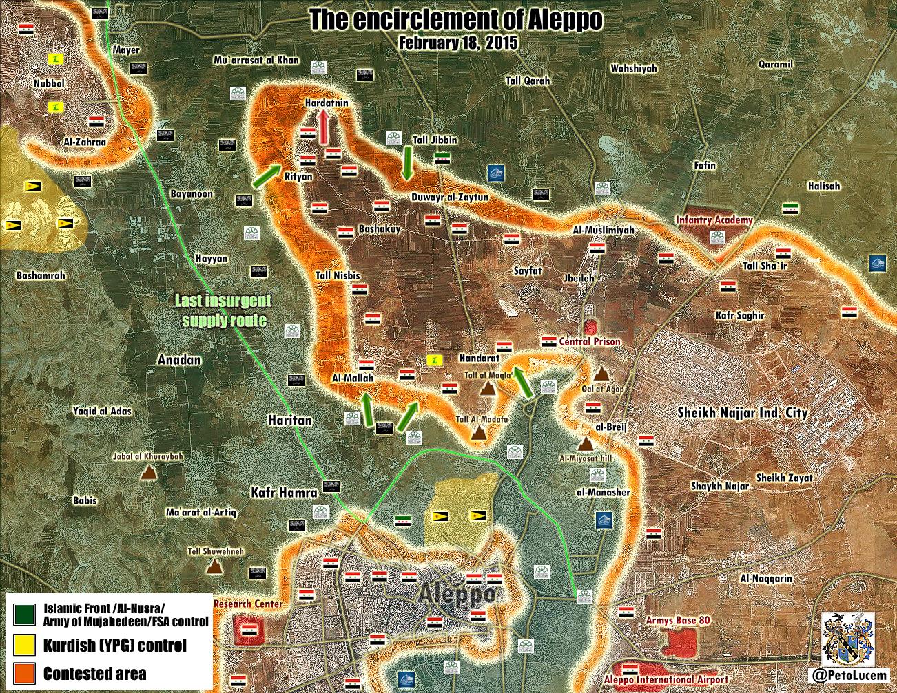
It looks like some more changes to the map are required: Neutral source Al-Monitor describes what appears to have been a large coordinated government offensive around Aleppo. It says regime forces through control of Saifat launched an offensive and captured Hardetneen and Bashkoy, and that ongoing contested fight for Ratyan is taking place: http://english.al-akhbar.com/content/blow-ankara-syrian-army-makes-advances-aleppo-offensive. On the western side of Aleppo, Al-Monitor reports that government forces made advances in al-Maamel and "able to control a number of farms in the west near Haritan and get close to the Castello crossroads, Aleppo’s northwestern entrance which is connected to the international road". It adds "Air Force intelligence forces stationed in the area to advance and control seven urban blocks in the vicinity of the Air Force Intelligence building and al-Rasoul al-Azam Mosque." and that regime army forces "was also able to advance in al-Rashidin al-Rabia"