
Talk:Highest unclimbed mountain: Difference between revisions
AnnaComnemna (talk | contribs) No edit summary |
No edit summary |
||
| Line 33: | Line 33: | ||
"is accepted in the climbing community" Sorry, the climbing community does not have the casting vote on what appears in Wikipedia, and no vote at all on what constitutes reality. But let it stand. Does this tradition, whether observed more in the breach or not, extend to other mountains? And if it does, what changes need to be made to other articles? [[User:AnnaComnemna|AnnaComnemna]] ([[User talk:AnnaComnemna|talk]]) 13:35, 11 March 2015 (UTC) |
"is accepted in the climbing community" Sorry, the climbing community does not have the casting vote on what appears in Wikipedia, and no vote at all on what constitutes reality. But let it stand. Does this tradition, whether observed more in the breach or not, extend to other mountains? And if it does, what changes need to be made to other articles? [[User:AnnaComnemna|AnnaComnemna]] ([[User talk:AnnaComnemna|talk]]) 13:35, 11 March 2015 (UTC) |
||
==Mount Kailash== |
|||
One of the unclimbed phenomena in the world needs to be added [[User:Salmanlla|Salmanlla]] ([[User talk:Salmanlla|talk]]) 04:17, 8 June 2016 (UTC) |
|||
Revision as of 04:18, 8 June 2016
| Climbing Unassessed | ||||||||||
| ||||||||||

I do not want to provoke an edit war, so I have applied the NPOV principle to the main article, but I firmly disagree with the POV that Gangkhar Puensum is wholly in Bhutan.
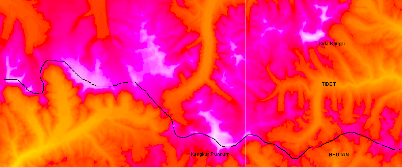
The local border with Tibet is a sensitive issue, but in the relevant area it can only take one logical course, the watershed divide. This clearly runs over the Gangkhar Puensum mountain. It follows that if the summit is wholly in Bhutan, then it would have to be on a spur, removed from the divide. A photograph taken of the main summit from Liangkang Kangri, a subsidiary top to the north, shows that the main summit is clean, with no such spur. It therefore follows that, in the absence of any formal agreement with China, the main summit is on the border, and NOT the exclusive possession of Bhutan.
It is worth noting that the 1986 Berry book was written at the time when the local topography was much less clear, but it is likely that the POV expressed there has been widely reproduced. Viewfinder 00:19, 10 January 2006 (UTC)
- I think what you have put now summarises the situation just fine. It seems that China and Bhutan have decided that their border disputes are not worth a war so surely an edit war is not justified here either! The Gangkhar Puensum article is careful in quoting sources claiming what is on what side of the border. That article itself does not state a point of view other than by saying "the highest mountain in Bhutan" it claims that the summit is in Bhutan or on the border with Tibet (China). My personal (and unprofessional) POV is that Kula Kangri (a higher mountain) is on the border and GP is in Bhutan. However, where the border is not definitely agreed, and where some maps muddle up KK and GP, this can only be rather unclear. BTW I'd love to know the prominence of GP! Thincat 09:50, 10 January 2006 (UTC)
The prominence of GP depends on its elevation relative to Kula Kangri. The prominences shown here are based on the assumption that Kula Kangri is lower. I cannot prove this, but in the absence of any modern and accurate measurements other than the Chinese ones, I accept the Chinese claim that Gangkhar Puensum is 7570m and that Kula Kangri is lower at 7538m. The course of the watershed border is shown on a web page that I have created, and I draw specific attention to the map. A border that includes Kula Kangri but passes north of Gangkhar Puensum deviates from the watershed border and makes no topographic sense. The extra Bhutanese territory that such a border creates is completely uninhabited. The only valley that would be included would be cut off from the rest of Bhutan by impenetrable mountains and glaciers. So what legal or other basis for such a border can there be? Viewfinder 13:28, 10 January 2006 (UTC)
First recorded ascent of an American mountain in the West.
The first recorded ascent of any mountain in the American West was Gray Back Peak (southwest of Colorado Springs, Colorado, by Zebulon Pike, Private Theodore Miller, Dr. John Robinson, and Private John Brown, on November 26, 1806. The next day the four climbers ascended Mt.Rosa, 11,499' which was the first recorded ascent of any American mountain into the Alpine zone. They were trying to ascend Pikes Peak, and gave up on the summit of Rosa, still 8 miles from their objective. Google " Zebulon Pike, Murphy, Mt. Rosa" for more details. John Murphy Pike historian — Preceding unsigned comment added by 76.25.184.188 (talk) 19:26, 5 December 2012 (UTC)
Kanchenjunga?
From the current Wikipedia article introduction.
"Kangchenjunga was first climbed on 25 May 1955 by Joe Brown and George Band, who were part of a British expedition. They stopped short of the summit as per the promise given to the Chogyal that the top of the mountain would remain inviolate. Every climber or climbing group that has reached the summit has followed this tradition.[7]"
That sounds like not climbed to me, however easily the remaining elevation could have been climbed, it wasn't. AnnaComnemna (talk) 19:47, 4 March 2015 (UTC)
- I think since that time people have become rather less respectful.[1] Thincat (talk) 20:31, 4 March 2015 (UTC)
- I am almost certain the practice of stopping a few feet short of the actual summit out respect for local beliefs is accepted in the climbing community as a completely valid ascent. We could announce the peak as the "world's highest unclimbed mountain" based on this technicality, but at best it probably wouldn't mean anything to the people who actually intend to climb such mountains. At worst, it would encourage the next summitting climber to simply step a foot on the highest point, defeating the purpose of the tradition.
- But as Thincat has pointed out, the question now appears to be moot in any case. The following is from a source concerning the practice in question:
- "The first assault pair of Joe Brown and George Band are successful, followed by a second successful ascent by Norman Hardie and Tony Streather. Out of respect for local beliefs, the actual summit itself remained virgin, a tradition that continued until recent years." - EverestNews.com
- Key words here "until recent years". This seems to imply that lately, climbers have dropped the tradition and now ascend to the highest point of the mountain. --RacerX11 Talk to meStalk me 23:03, 4 March 2015 (UTC)
"is accepted in the climbing community" Sorry, the climbing community does not have the casting vote on what appears in Wikipedia, and no vote at all on what constitutes reality. But let it stand. Does this tradition, whether observed more in the breach or not, extend to other mountains? And if it does, what changes need to be made to other articles? AnnaComnemna (talk) 13:35, 11 March 2015 (UTC)
Mount Kailash
One of the unclimbed phenomena in the world needs to be added Salmanlla (talk) 04:17, 8 June 2016 (UTC)