Ilejemeje: Difference between revisions
Appearance
Content deleted Content added
No edit summary |
Rescuing 1 sources and tagging 0 as dead. #IABot (v1.3beta4) |
||
| Line 67: | Line 67: | ||
It has an area of 95 km² and a population of 43,530 at the 2006 census. |
It has an area of 95 km² and a population of 43,530 at the 2006 census. |
||
The [[postal code]] of the area is 372.<ref>{{cite web |
The [[postal code]] of the area is 372.<ref>{{cite web|title=Post Offices- with map of LGA |work= |publisher=NIPOST |url=http://www.nipost.gov.ng/PostCode.aspx |accessdate=2009-10-20 |deadurl=yes |archiveurl=https://web.archive.org/web/20091007011423/http://www.nipost.gov.ng/PostCode.aspx |archivedate=2009-10-07 |df= }}</ref> |
||
==References== |
==References== |
||
Revision as of 09:29, 9 April 2017
Ilejemeje | |
|---|---|
| Country | |
| State | Ekiti State |
| Government | |
| • Type | Local Government |
| • Local Government Chairman and the Head of the Local Government Council | Oladimeji Joshua Ayo |
| • Local Government Secretary | Chief Joshua Ayodele |
| Time zone | UTC+1 (WAT) |
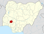
Ilejemeje is a Local Government Area of Ekiti State, Nigeria.It consist of seven towns.Its headquarters are in the town of Iye.
It has an area of 95 km² and a population of 43,530 at the 2006 census.
The postal code of the area is 372.[1]
References
- ^ "Post Offices- with map of LGA". NIPOST. Archived from the original on 2009-10-07. Retrieved 2009-10-20.
{{cite web}}: Unknown parameter|deadurl=ignored (|url-status=suggested) (help)

