Jethou: Difference between revisions
Headhitter (talk | contribs) m →Modern history: punctuation |
Rescuing 2 sources and tagging 0 as dead. #IABot (v1.3beta8) |
||
| Line 160: | Line 160: | ||
* [http://www.faedfiles.com/faednet/jethou/jethou.htm Jethou Homepage] Dead link |
* [http://www.faedfiles.com/faednet/jethou/jethou.htm Jethou Homepage] Dead link |
||
* [http://www.gutenberg.org/etext/17618 Free Gutenberg Project book, a Crusoe-like novel on Jethou] |
* [http://www.gutenberg.org/etext/17618 Free Gutenberg Project book, a Crusoe-like novel on Jethou] |
||
* [http://www.silverdalen.se/stamps/cje98/jethou.htm Stamps from Isle of Jethou] |
* [https://web.archive.org/web/20070112230952/http://www.silverdalen.se/stamps/cje98/jethou.htm Stamps from Isle of Jethou] |
||
* [http://www.britlink.org/jethou.html Island of Jethou at Britlink] Dead link |
* [https://web.archive.org/web/20090913010748/http://www.britlink.org/jethou.html Island of Jethou at Britlink] Dead link |
||
{{Coord|49|27|N|2|28|W|type:isle|display=title}} |
{{Coord|49|27|N|2|28|W|type:isle|display=title}} |
||
Revision as of 03:46, 22 April 2017
Jethou | |
|---|---|
Island | |
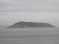
 Jethou from St. Peter Port, Guernsey | |
| Motto: Vigilare et admonere | |
 | |
| Coordinates (isle): 49°27′N 2°28′W / 49.450°N 2.467°W | |
| Crown dependency | |
| Seat | Manor House |
| Area | |
| • Total | 0.06875 sq mi (0.1781 km2) |
| Population (1996) | |
| • Total | 3 |
| • Density | 44/sq mi (17/km2) |
Jethou (/ʒɛˈtuː/ zhe-TOO) is a small island that is part of the Bailiwick of Guernsey in the Channel Islands. It is privately leased, and not open to the public.
It is immediately south of Herm and has an area of approximately 44 acres (18 ha).
History
There is evidence of flint manufacturing in an area exposed only at low water between the island and Crevichon which shows occupation around 10,000 BC.[1]
It is said that in AD 709 a storm washed away the strip of land that connected the island with Herm.[2]
The Viking name for the island was Keitholm.[3]
The island's name contains the Norman -hou suffix, meaning small island or small hill.
In 1416, it became part of Henry V's estate and still remains a Crown lease and now owned by the States of Guernsey.
On the top is a marker. It is said that in earlier times, pirates were hanged on it with chains, as on nearby Crevichon.
Modern history

In 1867 Lt Colonel Montague Fielden became tenant however he was discovered using the island as a storehouse for smuggling Brandy.[3]
From 1920 to 1923 it was leased by the Scottish novelist Compton MacKenzie along with Herm and remained part of that estate for years, although it is currently part of a different one.[3]
The British 1957 musical Free as Air by Dorothy Reynolds & Julian Slade was set on the fictitious island of 'Terhou', which was based on Jethou.
From September 1964 until December 1971 the island was occupied by the Faed family consisting of Mr Angus Faed, his wife Susan Faed and their four children, Colin, Erik, Colette and Amanda. Mrs. Susan Faed was the 22nd tenant of Jethou.[3]
In 1972, Charles Hayward, founder of the Firth Cleveland Group of Companies, purchased the Crown Tenancy of the island and lived there with his wife Elsie Darnell George until Sir Charles's death in 1983.
It is flanked by two islets, Crevichon to the north and Fauconniere to the south. There is one house on the island and two cottages as well as a large garage where vehicles such as quad bikes and tractors are stored.
It is now leased by Sir Peter Ogden of IT company Computacenter.
Recognised in 2016 as an area of international environmental importance under the Ramsar Convention.[4]
Politics
Unlike the largely autonomous islands of Sark and Alderney within the Bailiwick, Jethou is administered entirely by the States of Guernsey,[5] and elects members to the States of Deliberation as part of the St. Peter Port South electoral district.[6]
Wildlife
At the back (east) of Jethou, puffins can be seen swimming off the rocks.
See also
References
- ^ Cataroche, Jenny. The History and Archaeology of Jethou. L&C Press. ISBN 9781904332374.
- ^ [1] Archived August 16, 2015, at the Wayback Machine
- ^ a b c d "Jethou History". BBC. 22 April 2008.
- ^ "Herm and Jethou get Ramsar status". Guernsey Press. 28 January 2016.
- ^ [2] Archived January 17, 2012, at the Wayback Machine
- ^ [3] Archived December 30, 2011, at the Wayback Machine
Bibliography
- BBC Pronouncing Dictionary of British Names (Oxford University Press, 1971) ISBN 978-0194311250
