
Avery, Oklahoma: Difference between revisions
Content deleted Content added
JJMC89 bot (talk | contribs) Migrate {{Infobox settlement}} coordinates parameters to {{Coord}}, see Wikipedia:Coordinates in infoboxes |
Rescuing 1 sources and tagging 0 as dead. #IABot (v1.4) |
||
| Line 94: | Line 94: | ||
==External links== |
==External links== |
||
*[http://www.ghosttowns.com/states/ok/avery.html Avery - Ghost Town] |
*[http://www.ghosttowns.com/states/ok/avery.html Avery - Ghost Town] |
||
* [http://www.library.okstate.edu/okmaps/ Oklahoma Digital Maps: Digital Collections of Oklahoma and Indian Territory] |
* [https://web.archive.org/web/20121024013411/http://www.library.okstate.edu/okmaps/ Oklahoma Digital Maps: Digital Collections of Oklahoma and Indian Territory] |
||
*[http://www.abandonedok.com/forum/viewtopic.php?f=35&t=1465 "Ghost town of Avery, Oklahoma."] Accessed February 2, 2017. |
*[http://www.abandonedok.com/forum/viewtopic.php?f=35&t=1465 "Ghost town of Avery, Oklahoma."] Accessed February 2, 2017. |
||
Revision as of 13:09, 12 July 2017
Avery | |
|---|---|
 Avery Location within the state of Oklahoma | |
| Coordinates: 35°53′2″N 96°45′8″W / 35.88389°N 96.75222°W | |
| Country | United States |
| State | Oklahoma |
| County | Lincoln |
| Time zone | UTC-6 (Central (CST)) |
| • Summer (DST) | UTC-5 (CDT) |
Avery is a ghost town in Lincoln County, Oklahoma, United States. The community had a post office from September 16, 1902, until August 26, 1957. Founded as Mound City, it was renamed for Eastern Oklahoma Railway worker Avery Turner after the railroad built through the community.[1]
References
- ^ Morris, John (1977). Ghost Towns of Oklahoma. Norman, Oklahoma: University of Oklahoma Press. p. 229. ISBN 978-0-8061-1420-0.
{{cite book}}: Cite has empty unknown parameter:|coauthors=(help)
External links
- Avery - Ghost Town
- Oklahoma Digital Maps: Digital Collections of Oklahoma and Indian Territory
- "Ghost town of Avery, Oklahoma." Accessed February 2, 2017.
Municipalities and communities of Lincoln County, Oklahoma, United States | ||
|---|---|---|
| Cities | 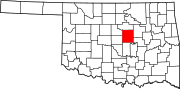 | |
| Towns | ||
| Unincorporated communities | ||
| Ghost towns | ||
| Footnotes | ‡This populated place also has portions in an adjacent county or counties | |
This Oklahoma state location article is a stub. You can help Wikipedia by expanding it. |
This United States ghost town-related article is a stub. You can help Wikipedia by expanding it. |