
Walls of Benin: Difference between revisions
m standard AWB cleanup, removed stub tag |
No edit summary |
||
| Line 1: | Line 1: | ||
The '''Walls of Benin''' were a combination of [[Rampart (fortification)|rampart]]s and [[moat]]s, called ''{{font|I|font=serif}}ya'' in the local language{{Which|date=November 2017}}, used as a defense of the ancient [[Kingdom of Benin]], which is present-day [[Benin City]], the capital of present-day [[Edo State|Edo]], Nigeria. It was considered the largest man-made structure lengthwise and was hailed as the largest earthwork in the world. It is larger than [[Sungbo's Eredo]].<ref name="African Queen">Pearce, Fred. [https://www.newscientist.com/article/mg16322035.100-the-african-queen.html?page=2 ''African Queen'']. New Scientist, 11 September 1999, Issue 2203.</ref> It enclosed {{convert|6500|km2}} of community lands. The combined length of the walls, many of which were outside the city, was over {{convert|16000|km|abbr=off}}. It was estimated that earliest construction began in 800 and continued into the mid-15th century. |
The '''Walls of Benin''' were a combination of [[Rampart (fortification)|rampart]]s and [[moat]]s, called ''{{font|I|font=serif}}ya'' in the local language{{Which|date=November 2017}}, used as a defense of the ancient [[Kingdom of Benin]], which is present-day [[Benin City]], the capital of present-day [[Edo State|Edo]], Nigeria. It was considered the largest man-made structure lengthwise and was hailed as the largest earthwork in the world. It is larger than [[Sungbo's Eredo]].<ref name="African Queen">Pearce, Fred. [https://www.newscientist.com/article/mg16322035.100-the-african-queen.html?page=2 ''African Queen'']. New Scientist, 11 September 1999, Issue 2203.</ref> It enclosed {{convert|6500|km2}} of community lands. The combined length of the walls, many of which were outside the city, was over {{convert|16000|km|abbr=off}}. It was estimated that earliest construction began in 800 and continued into the mid-15th century.{{Citation Needeed|date=January 2019} |
||
==Description== |
==Description== |
||
Revision as of 18:17, 25 January 2019
The Walls of Benin were a combination of ramparts and moats, called Iya in the local language[which?], used as a defense of the ancient Kingdom of Benin, which is present-day Benin City, the capital of present-day Edo, Nigeria. It was considered the largest man-made structure lengthwise and was hailed as the largest earthwork in the world. It is larger than Sungbo's Eredo.[1] It enclosed 6,500 square kilometres (2,500 sq mi) of community lands. The combined length of the walls, many of which were outside the city, was over 16,000 kilometres (9,900 miles). It was estimated that earliest construction began in 800 and continued into the mid-15th century.{{Citation Needeed|date=January 2019}
Description
The walls were built of a ditch and dike structure; the ditch dug to form an inner moat with the excavated earth used to form the exterior rampart.
The Benin Walls were ravaged by the British in 1897 during what has come to be called the Punitive expedition. Scattered pieces of the structure remain in Edo, with the vast majority of them being used by the locals for building purposes. What remains of the wall itself continues to be torn down for real estate developments.[2]
The Walls of Benin City was the world's largest man-made earth structure.[3] Fred Pearce wrote in New Scientist:
They extend for some 160 km in all, in a mosaic of more than 500 interconnected settlement boundaries. They cover 2,510 sq. miles (6,500 square kilometres) and were all dug by the Edo people. In all, they are four times longer than the Great Wall of China, and consumed a hundred times more material than the Great Pyramid of Cheops. They took an estimated 150 million hours of digging to construct, and are perhaps the largest single archaeological phenomenon on the planet.[1]
Ethnomathematician Ron Eglash has discussed the planned layout of the city using fractals as the basis, not only in the city itself and the villages but even in the rooms of houses. He commented that "When Europeans first came to Africa, they considered the architecture very disorganised and thus primitive. It never occurred to them that the Africans might have been using a form of mathematics that they hadn’t even discovered yet."[4]
A Portuguese captain described the city in 1691:“Great Benin, where the king resides, is larger than Lisbon; all the streets run straight and as far as the eye can see. The houses are large, especially that of the king, which is richly decorated and has fine columns. The city is wealthy and industrious. It is so well governed that theft is unknown and the people live in such security that they have no doors to their houses.” This was at a time when theft and murder were rife in London.[4]
World Heritage Status
This site was added, along with Sungbo's Eredo, to the UNESCO World Heritage Tentative List on 1 November 1995 in the Cultural category.[5]
-
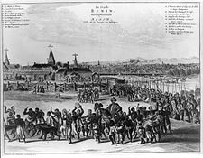 Benin city in the 17th century.
 -
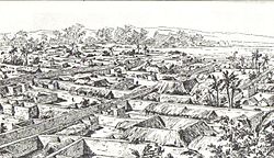 Benin in 1897


See also
References
- ^ a b Pearce, Fred. African Queen. New Scientist, 11 September 1999, Issue 2203.
- ^ http://www.beninmoatfoundation.org/clarioncall.html Archived July 25, 2011, at the Wayback Machine
- ^ Wesler,Kit W.(1998). Historical archaeology in Nigeria. Africa World Press pp.143,144 ISBN 978-0-86543-610-7, 9780865436107.
- ^ a b Koutonin, Mawuna (18 March 2016). "Story of cities #5: Benin City, the mighty medieval capital now lost without trace". Retrieved 2 April 2018.
- ^ Benin Iya / Sungbo' s Eredo UNESCO World Heritage Centre, retrieved 2009-12-05 [1]