Third Street (San Francisco): Difference between revisions
more important information first in lede / casting details are irrelevant here |
mNo edit summary |
||
| Line 1: | Line 1: | ||
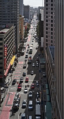
[[File:Third Street, San Francisco.jpg|thumb|Third Street seen from its Northern End at Market Street, with the San Francisco Bay in the far background]] |
[[File:Third Street, San Francisco.jpg|thumb|Third Street seen from its Northern End at Market Street, with the San Francisco Bay in the far background]] |
||
'''Third Street''' is a north-south street in [[San Francisco]], [[California]], running through the [[Civic Center, San Francisco, California|Downtown]], [[Mission Bay, San Francisco, California|Mission Bay]], [[Potrero Point]], [[Dogpatch, San Francisco, California|Dogpatch]], and [[Hunters Point, San Francisco, California|Bayview-Hunters Point]] neighborhoods. The road turns into [[Kearny Street (San Francisco)|Kearny Street]] north of [[Market Street (San Francisco)|Market Street]] and connects into [[Bayshore Boulevard (San Francisco)|Bayshore Boulevard]] south of Meade Avenue.<ref name="Map">{{citeweb|url=https://maps.google.com/maps?q=3rd+St,+San+Francisco,+CA,+USA&sa=X&oi=map&ct=image |title=Exact location of 3rd Street}}</ref> It was formerly called '''Kentucky Street''' in the [[Dogpatch, San Francisco, California|Dogpatch]] and '''Railroad Avenue''' in the [[Bayview, San Francisco, California|Bayview]].{{ |
'''Third Street''' is a north-south street in [[San Francisco]], [[California]], running through the [[Civic Center, San Francisco, California|Downtown]], [[Mission Bay, San Francisco, California|Mission Bay]], [[Potrero Point]], [[Dogpatch, San Francisco, California|Dogpatch]], and [[Hunters Point, San Francisco, California|Bayview-Hunters Point]] neighborhoods. The road turns into [[Kearny Street (San Francisco)|Kearny Street]] north of [[Market Street (San Francisco)|Market Street]] and connects into [[Bayshore Boulevard (San Francisco)|Bayshore Boulevard]] south of Meade Avenue.<ref name="Map">{{citeweb|url=https://maps.google.com/maps?q=3rd+St,+San+Francisco,+CA,+USA&sa=X&oi=map&ct=image |title=Exact location of 3rd Street}}</ref> It was formerly called '''Kentucky Street''' in the [[Dogpatch, San Francisco, California|Dogpatch]] and '''Railroad Avenue''' in the [[Bayview, San Francisco, California|Bayview]].<ref>{{citeweb|url=https://www.sfmta.com/blog/historic-travels-t-third|title=Historic Travels on the T Third}}</ref> |
||
Major League Baseball's [[San Francisco Giants]] play at [[Oracle Park]] on the intersection Third and King. |
Major League Baseball's [[San Francisco Giants]] play at [[Oracle Park]] on the intersection Third and King. |
||
Revision as of 22:25, 1 May 2019

Third Street is a north-south street in San Francisco, California, running through the Downtown, Mission Bay, Potrero Point, Dogpatch, and Bayview-Hunters Point neighborhoods. The road turns into Kearny Street north of Market Street and connects into Bayshore Boulevard south of Meade Avenue.[1] It was formerly called Kentucky Street in the Dogpatch and Railroad Avenue in the Bayview.[2]
Major League Baseball's San Francisco Giants play at Oracle Park on the intersection Third and King.
The majority of the street is served by the T Third Street light rail line.[3][4][5] It was the first new light rail line in San Francisco in more than half a century, and the first fully accessible line in the system. It is also the first true light rail line in the mostly streetcar Muni Metro system, as it operates primarily in the median.[citation needed]
In 2009, San Francisco Mayor Gavin Newsom proposed Third Street be renamed for former mayor Willie Brown.[6]
In the 1960s, Third Street was known as San Francisco's "skid row", with most of its (then much smaller) homeless population concentrating there.[7]
The street has featured as a filming location in numerous films, perhaps the most notable scene being in the James Bond film A View to a Kill (1985) where Bond escaped from police wrongly suspecting him of murder in a fire engine driven by Stacey Sutton and cut himself off from pursuing patrol cars by jumping over the rising Lefty O'Doul Drawbridge.[8]
References
- ^ "Exact location of 3rd Street".
- ^ "Historic Travels on the T Third".
- ^ "SAN FRANCISCO / Third Street seeing streetcars / Test runs for light-rail project begin at last".
- ^ "3rd St. rail line goes full-time on Saturday".
- ^ "MUNI 3rd Street Light Rail".
- ^ "S.F.'s Third St. may be renamed after ex-mayor".
- ^ Fagan, Kevin (2016-06-26). "Homelessness looks the same as it did 20 years ago". San Francisco Chronicle. Retrieved 2019-03-12.
{{cite web}}: Cite has empty unknown parameter:|dead-url=(help) - ^ "viewtoakill".
"San Francisco County, California" is an invalid category parameter for Template:Coord missing.
The problem is usually caused either by a spelling mistake or by an-over-precise category.
For a full list of categories, see Category:Unclassified articles missing geocoordinate data and its subcategories.

