
Tauthali: Difference between revisions
Content deleted Content added
No edit summary Tags: Mobile edit Mobile web edit |
Grammar |
||
| Line 70: | Line 70: | ||
}} |
}} |
||
'''Tauthali''' [[Hajipur]] is a village in [[Sindhupalchok District]] in the [[Bagmati Zone]] of central [[Nepal]]. <u>Tauthali</u> is 110 km |
'''Tauthali''' [[Hajipur]] is a village in [[Sindhupalchok District]] in the [[Bagmati Zone]] of central [[Nepal]]. <u>Tauthali</u> is 110 km from [[Kathmandu|Katmandu]]. In the 2013 Nepal census it had a population of 3,886 in 670 houses.<ref>{{Cite web| url=http://www.digitalhimalaya.com/collections/nepalcensus/form.php?selection=1|title=Nepal Census 2001|work=Nepal's Village Development Committees|publisher=[[Digital Himalaya]]|accessdate=2008-08-24}}</ref> After the devastating earthquake of 2072 almost every house was destroyed including religious sites such as Tripura Sundari Mai. The population grew to around 7000. The villagers started building concrete houses with the help of the government earthquake fund. |
||
== Attractions == |
== Attractions == |
||
Revision as of 14:58, 24 June 2019
This article needs additional citations for verification. (May 2018) |
Tauthali
तौथली hajipur | |
|---|---|
 Tauthali Location in Nepal | |
| Coordinates: 27°44′N 85°55′E / 27.73°N 85.91°E | |
| Country | |
| Zone | Bagmati Zone |
| District | Sindhupalchok District |
| Population (2013) | |
| • Total | 3,886 |
| • Religions | Hindu especially newar community |
| Time zone | UTC+5:45 (Nepal Time) |
Tauthali Hajipur is a village in Sindhupalchok District in the Bagmati Zone of central Nepal. Tauthali is 110 km from Katmandu. In the 2013 Nepal census it had a population of 3,886 in 670 houses.[1] After the devastating earthquake of 2072 almost every house was destroyed including religious sites such as Tripura Sundari Mai. The population grew to around 7000. The villagers started building concrete houses with the help of the government earthquake fund.
Attractions
-
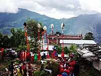 lingha nach

- Newari culture is celebrated on festive occasions, especially the curd festival, like holi with curd.
- Trekking route from Kharidhungha to Tauthali covers around 10km.
- View of Honey hill (Mahabhir Jarna) waterfall
- One of the country's biggest ropeways
- View of mountains like Ganesh and Jugal
-
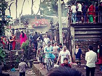 playing curd (dahi jatra)

References
- ^ "Nepal Census 2001". Nepal's Village Development Committees. Digital Himalaya. Retrieved 2008-08-24.
External links

This article about a location in Bagmati Province of Nepal is a stub. You can help Wikipedia by expanding it. |