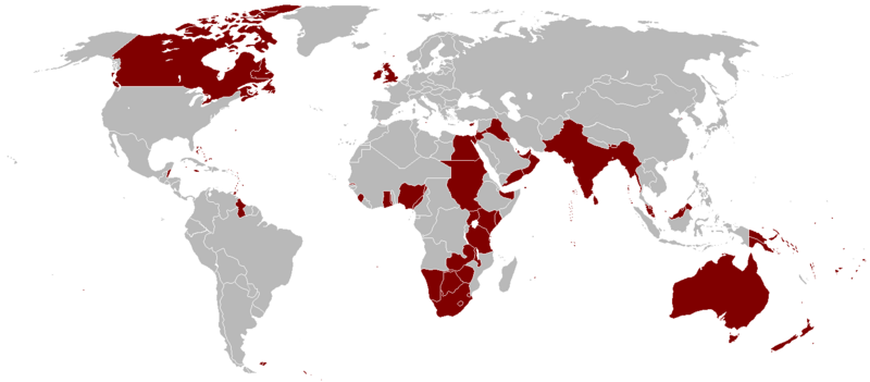
File:British Empire 1921.png
Appearance

Size of this preview: 800 × 351 pixels. Other resolutions: 320 × 140 pixels | 640 × 281 pixels | 1,425 × 625 pixels.
Original file (1,425 × 625 pixels, file size: 58 KB, MIME type: image/png)
File history
Click on a date/time to view the file as it appeared at that time.
| Date/Time | Thumbnail | Dimensions | User | Comment | |
|---|---|---|---|---|---|
| 13:41, 27 August 2008 |  | 1,357 × 628 (44 KB) | IJA | Added Malta and Korea was not split in 2 back then, so fixed boarder | |
| 03:46, 17 April 2008 |  | 1,357 × 628 (44 KB) | Votolom | fixed several border errors | |
| 14:41, 28 June 2006 |  | 1,357 × 628 (44 KB) | Rosss | {{GFDL}} | |
| 01:09, 2 January 2005 |  | 1,357 × 628 (44 KB) | Nickshanks | Taken from en: |
File usage
The following pages on the English Wikipedia use this file (pages on other projects are not listed):
- British Empire
- British colonization of the Americas
- Core countries
- George V
- History of monarchy in the United Kingdom
- History of the United Kingdom
- History of the United Kingdom during the First World War
- Imperialism
- Interwar Britain
- Interwar period
- Military production during World War II
- Monarchy of the United Kingdom
- Political positions of Winston Churchill
- Racial views of Winston Churchill
- Shooting an Elephant
- Singapore strategy
- Timeline of British diplomatic history
- United Kingdom
- Western imperialism in Asia
- Winston Churchill
- World-systems theory
- World domination
- Talk:British Empire/Archive 4
- Talk:Elizabeth II/Archive 42
- User:5heeteeeee/sandbox
- User:Chrislid49/sandbox
- User:Colonialist77
- User:Falcaorib/United Kingdom
- User:Flowism/Libber Kingdom
- User:GSTQ
- User:JGHowes/Templates
- User:JGHowes/Userbox/Britannia
- User:Jr8825/sandbox 3
- User:LucaSimone (Unipd)/sandbox2
- User:Nachlader
- User:Palaeovia
- User:Sooner016/World stratification
- User:Xultsch
- Wikipedia:Graphics Lab/Map workshop/Archive/2017/Jun 2017
- Wikipedia:Graphics Lab/Map workshop/Archive/Nov 2020
Global file usage
The following other wikis use this file:
- Usage on af.wikipedia.org
- Usage on als.wikipedia.org
- Usage on am.wikipedia.org
- Usage on ar.wikipedia.org
- Usage on ast.wikipedia.org
- Usage on azb.wikipedia.org
- Usage on az.wikipedia.org
- Usage on bg.wikipedia.org
- Usage on bn.wikipedia.org
- Usage on br.wikipedia.org
- Usage on ca.wikipedia.org
- Usage on cs.wikipedia.org
- Usage on da.wikipedia.org
- Usage on de.wikipedia.org
- Usage on el.wikipedia.org
- Usage on en.wikiquote.org
- Usage on en.wikivoyage.org
- Usage on eo.wikipedia.org
- Usage on es.wikipedia.org
View more global usage of this file.

