
Low coasts mitigation
Mitigation
Present situation in the World and Europe
The coastal zone is a dynamic area of natural change and of increasing human use. They occupy less than 15% of the earth's land surface; yet accommodate more than 50% of the world population (it is estimated that 3.1 billion people live within 200 kilometres from the sea). With three-quarters of the world population expected to reside in the coastal zone by 2025, human activities originating from this small land area will impose an inordinate amount of pressures on the global system. Coastal zones contain rich resources to produce goods and services and are home to most commercial and industrial activities. In the European Union, almost half of the population now lives within 50 kilometres of the sea and coastal zone resources produce much of the Union’s economic wealth. The fishing, shipping and tourism industries all compete for vital space along Europe’s estimated 89 000 kilometres of coastline, and coastal zones contain some of Europe’s most fragile and valuable natural habitats. Shore protection consists up to the 50's of interposing a static structure between the sea and the land to prevent erosion and or flooding, and it has a long history. From that period new tecnical or friendly policies have been developed to preserve the environment when possible. Is already important where there are extensive low-lying areas that require protection. For instance: Venice, New Orleans, Nagara river in Japan, Holland, Caspian Sea
Historic summary
Coastal engineering, as it relates to harbours, starts with the development of ancient civilizations together with the origin of maritime traffic, perhaps before 3500 B.C. Docks, breakwaters, and other harbour works were built by hand and often in a grand scale.
Some of the harbour works are still visible in a few of the harbours that exist today, while others have recently been explored by underwater archaeologists. Most of the grander ancient harbour works have disappeared following the fall of the Roman Empire.
Most ancient coastal efforts were directed to port structures, with the exception of a few places where life depended on coastline protection. Venice and its lagoon is one such case. Protection of the shore in Italy, England and the Netherlands can be traced back at least to the 6th century. The ancients understood such phenomena as the Mediterranean currents and wind patterns and the wind-wave cause-effect link.
The Romans introduced many revolutionary innovations in harbour design. They learned to build walls underwater and managed to construct solid breakwaters to protect fully exposed harbours. In some cases wave reflection may have been used to prevent silting. They also used low, water-surface breakwaters to trip the waves before they reached the main breakwater. They became the first dredgers in the Netherlands to maintain the harbour at Velsen. Silting problems here were solved when the previously sealed solid piers were replaced with new "open"-piled jetties. The Romans also introduced to the world the concept of the holiday at the coast.
The threat of attack from the sea caused many coastal towns and their harbours to be abandoned. Other harbours were lost due to natural causes such as rapid silting, shoreline advance or retreat, etc. The Venice lagoon was one of the few populated coastal areas with continuous prosperity and development where written reports document the evolution of coastal protection works. Engineering and scientific skills remained alive in the east, in Byzantium, where the Eastern Roman empire survived for six hundred years while Western Rome decayed.
Modern Age
Leonardo da Vinci could be considered the precursor of coastal engineering science, offering ideas and solutions often more than three centuries ahead of their common acceptance. Although great strides were made in the general scientific arena, little improvement was done beyond the Roman approach to harbour construction after the Renaissance. In the early 19th century, the advent of the steam engine, the search for new lands and trade routes, the expansion of the British Empire through her colonies, and other influences, all contributed to the revitalization of sea trade and a renewed interest in port works.
Twentieth century
Evolution of shore protection and the shift from structures to beach nourishment. Prior to the 1950s, the general practice was to use hard structures to protect against beach erosion or storm damages. These structures were usually coastal armoring such as seawalls and revetments or sand-trapping structures such as groins. During the 1920s and ‘30s, private or local community interests protected many areas of the shore using these techniques in a rather ad hoc manner. In certain resort areas, structures had proliferated to such an extent that the protection actually impeded the recreational use of the beaches. Erosion of the sand continued, but the fixed back-beach line remained, resulting in a loss of beach area. The obtrusiveness and cost of these structures led in the late 1940s and early 1950s, to move toward a new, more dynamic, method. Projects no longer relied solely on hard coastal defence structures, as techniques were developed which replicated the protective characteristics of natural beach and dune systems. The resultant use of artificial beaches and stabilized dunes as an engineering approach was an economically viable and more environmentally friendly means for dissipating wave energy and protecting coastal developments.
Five policies (strategies) for managing coastal erosion
There are five generic policies (strategies) as a starting point for any policy's related assessment in the fields of coastal defense.
● Do nothing, no protection, leading to eventual abandonment
● Hold the line, shoreline protection, whereby seawalls are constructed around the coastlines
● Move seawards, by constructing new defences seaward the original ones
● Limited intervention, accomodation, by which adjustment are made to be able to cope with inundation, raising coastal land and buildings vertically
● managed retreat or realignment, which plans for retreat and adopts engineering solutions that recognise natural processes of adjustment, and identifying a new line of defence where to construct new defences
The decision to choose an strategy is site-specific, depending on pattern of relative sea-level change, geomorphological setting, sediment availability and erosion, as well a series of social, economic and political factors.
Introduction
Over the past hundred years the limited knowledge of coastal sediment transport processes at the local authorities level has often resulted in inappropriate measures of coastal erosion mitigation. In many cases, measures may have solved coastal erosion locally but have exacerbated coastal erosion problems at other locations -up to tens of kilometers away- or have generated other environmental problems.
Do nothing
The 'do nothing' option, involving no protection, is a cheap and expedient way to let the coast take care of itself. It involves the abandonment of coastal facilities when they are subject to coastal erosion, and either gradually landward retreat or evacuation and resettlement elsewhere. It is clearly not always feasible and accepted by stakeholders.
Managed retreat
Realignment of assets (removing or abandoning houses and other constructions from the erosion-prone areas. Managed retreat allows an area that was not previously exposed to flooding by the sea to become flooded. This process is usually in low lying estuarine or deltaic areas and almost always involves flooding of land that has at some point in the past been reclaimed from the sea. Managed retreat is often a response to a change in sediment bucget, or to sea level rise, where the impact of global sea level rise is exacerbated by local subsidence of the land surface In the Ebro delta (Spain) coastal authorities have planned to buy m of the 500 coastal fringe in the stronger erosive zone of the North coast, affecting rice fields, to allow limited interventions as rebuild coastal dunes (MMA 2005, Sitges, Meeting on Coastal Engineering; EUROSION project). In the UK, the first managed retreat site was an area of 0.8 ha at Northey Island in Essex flooded in 1991, followed in 1995 by larger sites at Tollesbury and Orplands.
Hold the line
Human strategies on the coast have been heavily based on a static engineered response, whereas the coast is in, or strives towards, a dynamic equilibrium. Solid coastal structures are built and persist because they protect expensive properties or infrastructures, but they often relocate the problem downdrift or to another part of the coast. Soft options like beach nourishment, while also being temporary and needing regular replenishment, appear more acceptable, and go some way to restore the natural dynamism of the shoreline. However in many cases there is a legacy of decisions that were made in the past which have given rise to the present threats to coastal infrastructure and which necessitate immediate shore protection. For instance, the seawall and promenade of many coastal cities in Europe represents a highly engineered use of prime seafront space, which might be preferably designated as public open space, parkland and amenities if it were available today. Such open space might also allow greater flexibility in terms of future land-use change, for instance through managed retreat, in the face of threats of erosion or inundation as a result of sea-level rise. Foredunes areas represent a natural reserve which can be called upon in the face of extreme events; building on these areas leaves little option but to undertake costly protective measures when extreme events (whether amplified by gradual global change or not) threaten. Managed retreat can comprise 'setbacks', rolling easements and other planning tools including building within a particular design life. Maintenance of those structures or soft techniques can arrive at a critical point (economically or environmental) to change adopted strategy.
● Structural or hard engineering techniques, i.e. using permanent concrete and rock constructions to “fix” the coastline and protect the assets locate behind. These techniques -seawalls, groins, detached breakwaters or revetments- represent a significant share of protected shoreline in Europe (more than 70%)
● Soft engineering techniques (e.g. sand nourishments), building with natural processes and relying on natural elements such as sands, dunes and vegetation to prevent erosive forces from reaching the backshore
Hard techniques
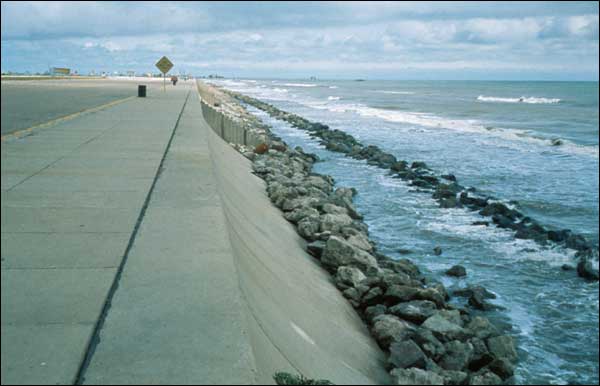
A seawall is a form of hard coastal defence constructed on the inland part of a coast to reduce the effects of strong waves and to defend the coast around a town or harbour from erosion. The walls can be sloping, vertical or curved to reflect wave power. The term is typically used to describe walls built on the land parallel to the coast, but may also apply to breakwaters and groynes which are built in the water. Seawalls may be constructed from a variety of materials: most commonly, they are constructed of reinforced concrete, boulders, steel, or gabions.
Seawalls are effective defences in the short term, but may cause erosion in the long run. They cause the energy of the backwash to be reflected to the shoreface, so the beach materials are gradually eroded. Seawalls require constant maintenance, as the waves will constantly attack the base of the walls and cause them to be weakened. Seawalls are very expensive to build.
Seawall types

A range of seawall types can be envisaged in relation to wave energy, resembling cliff and beach profiles.

Vertical seawalls are built in particularly exposed situations. These reflect wave energy and under storm conditions standing waves (clapotis) will develop. In some cases piles are placed in front of the wall to lessen wave energy slightly. Curved or stepped seawalls are designed to enable waves to break and to dissipate wave energy. The curve can also prevent the wave overtopping the wall, and provide additional protection for the toe of the wall.

A series of mound-type structures are used in lesser energy settings.

The least exposed sites involve the lowest-cost technology, bulkheads or revetments of sand bags or geotextiles. These serve to armour the shore and impede erosion. They may be either watertight, covering the slope completely, or porous, to allow water to filter through after the wave energy has been dissipated.

Breakwater

A breakwater (structure) is constructed some distance away from the coast or built with one end linked to the coast. Breakwaters may be either fixed or floating: the choice depends on normal water depth and tidal range.

Offshore breakwaters reduce the intensity of wave action in inshore waters and thereby reduce coastal erosion

Seawalls are subject to damage, and overtopping by big storms can lead to problems of drainage of water that gets behind them. The wall also serves to encourage erosion of beach deposits from the foot of the wall and can increase longshore sediment transport.
Groins (groynes)


A groin is constructed across the beach, perpendicular to the shoreline, and is designed to trap sand moving in the longshore transport system. As sand accumulates on the updrift side of the groin, the beach at that location becomes wider.

However, this is often accompanied by accelerated erosion of the downdrift beach, which receives little or no sand via longshore transport. It is important to realize that groins do not add any new sand to the beach, but merely retain some of the existing sand on the updrift side of the groin.
Groins are usually constructed from materials including steel, timber, or stone. The length, elevation, and spacing between groins should be designated on the basis of local wave energy and beach slope. Groins that are too long or too high tend to accelerate downdrift erosion because they trap too much sand. Groins that are too short, too low, or too permeable are ineffective because they trap too little sand. Flanking may occur if a groin does not extend far enough landward. Groins are generally constructed in groups called groin fields.
Spacing of groynes and the gradual chain reaction as groynes fill from updrift to downdrift.
Soft techniques
Beach nourishment
Beach nourishment is a process by which sediment (usually sand) lost through longshore drift or erosion is replaced on a beach. It involves the transport of the nourishment material from one area to the affected area. This process is relatively inexpensive, depending upon the source (and thus the cost) of the sand. Beach nourishment could be part of a broader coastal defence scheme.
Beach nourishment projects are usually constructed along shorelines where an erosional trend is present that could be either natural or a result of human activities. In those cases where this trend is due to human activities, the project will perform much better if the cause of the erosional trend can be minimized or eliminated.
see these set of very interesting pictures [1] [2] [3] [4] [5]
![[1]](http://marine.rutgers.edu/geomorph/oceancityfill.jpg)
![[3]](http://www.riverbills.com/pic_of_the_day/091505_dredge_pumping_sand.jpg)
However, if care is not taken to deal with the sustainability of the littoral environment then it may be necessary to regularly renourish a beach. Often the economic activity generated through beach tourism seems to compensate for the cost of the works, but some environmental issues could derive from a repetitive nourishment.
Examples:
North Gold Coast, Queensland, Australia
Gold Coast Beaches have experienced periods of severe beach erosion. In 1967 a series of 11 cyclones removed most of the sand from Gold Coast beaches. The Government of Queensland engaged engineers from Delft University in Holland to advise what to do about the beach erosion. The Delft Report was published in 1971 and outlined a series of works for Gold Coast Beaches, that included beach nourishment and an artificial reef. By 2005 most of the recommendations of the 1971 Delft Report had been implemented. The Gold Coast City Council commenced implementation of a new Protection Strategy for the Palm Beach, but ran into considerable opposition from the community participating in a NO REEF protest campaign. The Gold Coast City Council then committed to completing a review of beach management practices to update the Delft Report click here for further information.
Holland
A lot of interestin information on this example can be found at: The National Institute for Coastal and Marine Management
Sand dune stabilization
Vegetation encourages dune growth by trapping and stabilising blown sand. Transplanting marram grass to the face of eroded dunes will enhance the natural development of yellow dunes above the limit of direct wave attack. Sand couchgrass or lyme grass can be transplanted to encourage the growth of new foredunes along the toe of existing dunes, as these species are tolerant to occasional inundation by seawater. Planting grasses from seed can be undertaken but will not normally be successful in the very active foredune environment. These natural dune grasses act to reduce wind speeds across the surface, thereby trapping and holding sand. They grow both vertically and horizontally as the sand accumulates. - Adaptation from: © Scottish Natural Heritage - [6]
Move seaward
The futility of trying to predict future scenarios where there ia a large human influence is clearly apparent. Even future climate is to a certain extent a function of what humans choose to make it, with recognition that greenhouse gas emissions influence climate and could be controlled. Future climate and non-climate scenarios are interlinked, and future coasts could to some extent be what planners choose to make them. Nevertheless, in some cases a need of emerged areas for big infrascructures like coastal airports, harbours, etc. or for protective policy, move seaward strategy can be adopted. Some examples from EUROSION are: Koge Bay (Dk) Western Scheldt estuary (NI), Chatelaillon (F), Ebro delta (E)[7]
Coastal erosion is already widespread, and there are many coasts where exceptional high tides or storm surges result in encroachment on the shore, impinging on human activity. If the sea rises, many coasts that are developed with infrastructure along or close to the shoreline will be unable to accomodate erosion, and will experiment “coastal squeeze”. This occur where the ecological or geomorphological zones that would normally retreat landwards encounter solid structures and are squeezed out. Wetlands, salt marsh and mangroves, and adjacent fresh water wetlands are particularly likely to suffer from this squeeze.
Event warning
Tsunamis cannot be prevented or precisely predicted, but there are some warning signs of an impending tsunami. Regions with a high risk of tsunamis may use specific warning systems (with sensors) to detect them, and warn the general population before the wave reaches land and to permit evacuation of coastal areas.
Tsunami warnings for most of the Pacific Ocean are issued by the Pacific Tsunami Warning Center (PTWC), operated by the United States's NOAA in Hawaii. A second NOAA's Tsunami Warning Center is located in Alaska, and issues warnings for the west coast of North America. (http://www.tsunamiready.noaa.gov)
Both of the tsunami warning centers use earthquake information, tide gauges and now a new tool from NOAA - tsunami detection buoys. In late June 2006, a warning system became active for the Indian Ocean (IOTWS). In addition to international warning systems there are regional (or local) warning system centres that use seismic data about nearby earthquakes to determine if there is a possible local threat of a tsunami.
Although meteorological surveys alert about hurricanes or severe storms, in the areas where the risk of coastal flooding is particularly high, there are specific storm surge warnings.
Holland: http://www.svsd.nl/index.cfm?taal=en
Spain: http://www.puertos.es/externo/clima/Nivmar/nivmareng.html
To sign in the USA: http://hudson.dl.stevens-tech.edu/SSWS/
Great Britain: http://www.environment-agency.gov.uk/subjects/flood/floodwarning/
USA: http://www.stormready.noaa.gov
Storm surge barriers
A prophylactic method introduced after the North Sea Flood of 1953 is the construction of dams and storm surge barriers. They are habitually open and allow free passage, but close when the land is under threat of a storm surge.
Example: The Thames Flood Barrier to protect London (completed in 1982):
http://www.environment-agency.gov.uk/regions/thames/323150/335688/341764/
http://www.floodlondon.com/floodtb.htm
The Thames Flood Barrier is the world's largest movable flood barrier. Built between 1974 and 1986 at a cost of 370 million pounds, the Barrier divides the river Thames into six channels between nine large concrete piers.
The Barrier forms a major part of the flood defence system protecting London against rising water levels and tidal surges and consists of four large central gates each 61 metres long, and two outer two gates each 31 meters long. The gates are normally left open to allow ships to pass through, but can be rotated closed to stop water travelling up the Thames estuary.
Before 1990, the number of barrier closures was one to two per year on average. Since 1990, the number of barrier closures has increased to an average of about four per year. The sea level rise menaces to exceed the Barrier's protection about the year 2030 (the time when the designers themselves thought improvements might have to be made), but if the rise exceeds the present prevision the allowance could be surpassed as early as 2010. This does not mean that flooding is certain, but it does alter the probabilities in the design calculation.
Climate change refers to the variation in the Earth's global climate or in regional climates over time. It describes changes in the variability or average state of the atmosphere — or average weather — over time scales ranging from decades to millions of years. These changes may come from processes internal to the Earth, be driven by external forces (e.g. variations in sunlight intensity) or, most recently, be caused by human activities
Recent sea level rise

This figure shows the change in annually averaged sea level at 23 geologically stable tide gauge (a device for measuring sea level) sites with long-term records The thick dark line is a three-year moving average of the instrumental records. This data indicates a sea level rise of ~18.5 cm from 1900-2000. For comparison, the recent annually averaged satellite altimetry data from TOPEX/Poseidon are shown in red. These data indicate a somewhat higher rate of increase. Much of recent sea level rise has been attributed to global warming, the observed increase in the average temperature of the Earth's atmosphere and oceans in recent decades and its projected continuation into the future.
Post-glacial sea level rise
Present sea level had been almost stable during the last 6 or 7 thousand years, after the great changes occurred from the ending of last glaciation.

This figure shows sea level rise since the end of the last glacial episode.
The lowest point of sea level during the last glaciation is generally argued to be approximately 130 +/- 10 m below present sea level and to have occurred at approximately 22 +/- 3 thousand years ago. The time of lowest sea level is more or less equivalent to the last glacial maximum (21000 y). Prior to this time, ice sheets were still increasing in size so that sea level was decreasing semi-continuously over a period of approximately 100,000 years. Sea level rise in the last 6000 years would not exceed 2 meters.
Protection against the sea level rise in the 21th century
Acceleration in sea-level rise has been observed. A recent study found a sea-level rise from January 1870 to December 2004 of 195 mm, equal to an average sea-level rise of 1.7 ± 0.3 mm per year in the 20th century. This yearly rise is also increasing by 0.013 ± 0.006 mm per year. This is an important confirmation of climate change simulations, which projected this acceleration
Seawalls and breakwaters are generally expensive to construct, and the costs to build protection in the face of sea-level rise would be enormous.
Changes on sea level have a direct adaptative response from beaches and coastal systems, as we can sea in the succession of a lowering sea level. When sea level rise also coastal sediments are in part pushed up by wave and tide energy, then we must think that sea rise process have a component of sediment transport landwords or going up. This results in a dynamic model of rise effect with a continuous sediment displacement that is not compatible with static models where changing coast line is only based on topographic data..

Coastal sedimentary. Model for a lowering sea level from T1 to T5
Monitoring coastal zones
Coastal zone managers are faced with difficult and complex choices in deciding how best to reduce property damage in the shorelines. One of the problems they face is errors and uncertainties in the information available to them on the processes that cause erosion of beaches. Video-based monitoring lets collect data continuously at low cost and produce analyses of shoreline processes over a wide range of averaging intervals. http://www.planetargus.com/Upham%20Beach%20Oblique.mov Upham Beach Oblique.mov (7,7 M)
Argus Beach Monitoring Stations http://www.planetargus.com
European monitoring sites can be found and accessed through: http://argus-data.wldelft.nl/index.html
The complete world sites are at: http://cil-www.oce.orst.edu
Policy recommendations
European Commission
Coastal protection The preliminary modelling results of the physical impacts and costs of sea-level rise in the EU show significant damages, in particular where adaptation would not be undertaken (e.g. through enhanced coastal protection). Adaptation can reduce the total costs in the medium term by 7 to 50% and in the long run by more than 70%. But significant total costs will still be incurred due to expenditure on adaptation measures and residual climate change impacts. Significant populations are threatened with displacement by flooding and to a lesser extent coastal erosion.

The impact of adaptation measures on residual damage of low and high sea level rise

Integrated Coastal Zone Management
Integrated Coastal Zone Management (ICZM
There is no magic solution to the problems faced by Europe's coasts. What is needed is an integrated approach which takes into account the physical, economic, cultural and institutional aspects of each particular coastal region. Such an approach, known as Integrated Coastal Zone Management (ICZM), seeks to do just that. Integrated Coastal Zone Management is an approach promoted by the European Commission which aims to bring together the different EU, national, regional and local policies that affect the coastal areas of the EU into an environmentally and economically sustainable integrated strategy. The principles at the heart of ICZM are simple and straightforward. First of all, coastal zones are influenced by a range of piecemeal but interconnected policies. The ICZM strategy provides for a holistic approach which will study the cause and effect of each of these. The ICZM process brings together all interested parties of a coastal area into designing a strategy for their region. Implementing a viable strategy is no easy task. It is for this reason that the European Commission will facilitate the exchange of experiences in the field of ICZM. This principle lies at the heart of the European Commission's recommendation following the analysis of 35 pilot projects conducted on Europe's coasts between 1996 and 1999.
See also
External Links
- The Tollesbury and Orplands Managed Retreat Sites
- International Coastal Management
- Trailing suction hopper dredgers
- Welcome to the Coastal Research website
- Beach Nourishment: A Guide for Local Government Officials
- West Coast & Alaska Tsunami Warning Center
- Pacific Tsunami Warning Center
- NOAA Tsunami - Warnings and Forecasts
- ITIC
- Indian Ocean Tsunami Warning Center
main contribution from University of Barcelona, Spain